| GISdevelopment.net ---> AARS ---> ACRS 1997 ---> Poster Session R |
Agro-Ecological Zoning for
South West Selangor using Remote Sensing and Geographic Information System
K. F. Loh, M. Halid, N.
Surip and S. A. Hashim
Malaysian Centre For Remote Sensing (MACRES)
5th Floor, City Square Center, Jalan Tun Razak, 50400 Kuala Lumpur
Tel: 603-2645640 Fax: 603-264
E-mail : lpa@macres.gov.my
Abstract
Malaysian Centre For Remote Sensing (MACRES)
5th Floor, City Square Center, Jalan Tun Razak, 50400 Kuala Lumpur
Tel: 603-2645640 Fax: 603-264
E-mail : lpa@macres.gov.my
MACRES has conducted a study on agro-ecological zoning of South West Selangor using the integration of remote sensing and Geogrphic Information System (GIS). Five parameters - land cover/use, landform, terrain, soil and climate were used for agro-suitability assessment adopting the procedure sin the UN- Food and Agriculture Organisation (FAO) document entitled 'Agro-ecological Zoning'. The land cover/use, landform and soil layers were generated from visual interpretation of satellite data accompanied by intensive ground verifications. The terrain layer was produced from a Digital Elevation model (DEM) derived from digitized contour lines. Two climatic layers-duration of dry season and annual rainfall distribution were generated through interpolation of point files digitized in the GIS. Crop requirements data were taken from the FAO guideline with modifications to suit the Malaysian environment setting. Four crops - rubber, oil palm, cocoa and paddy were assessed because of their socio-economic significance to the state of Selangor, Malaysia. The agro-ecological zone (AEZ) map was produced using overlay analysis technique in the GIS. The agro-land suitability map was generated by matching the crop requirements with the land characteristics in each AEZ unit through cross-tabulation method, giving due considerations to the present agricultural land use.
1.0 Introduction
Agriculture land in the state of Selangor occupies some 46% of the total land area, comprising mainly of oil palm, rubber, cocoa and paddy. In line with the National Agricultural Policy the state is targeting for 60% self sufficiency in rice production. Industrial crops- oil palm, rubber and cocoa, which are expected to generate more value added commercial products to meet the domestic and international markets, will be give emphasis.
2.0 Objectives
The main objective of this study is to delineate agro-ecological and agro-land suitability zones for the state of Selangor, Malaysia using the integration of remote sensing and GIS technologies. However this paper presents the results obtained over over a pilot area- South West Selangor.
3.0 The Study Area
The state of Selangor covers an area of some 8000 square kilometers and is located between latitudes 2.58 N and 3.83 N and longitudes 101.17 E and 102.00 E.
The Main Range of post traissic biotic granite intrusion, having narrow valleys and steep crest., occurs in the north-east of Selangor. Occurring on the fringe of this range is a metamorphic zone of schists and quartzites with hilly to steep terrain. Away from the range and towards the straits of Malacca, where the folded sedimentary zone was least altered, the topography is mainly undulating. Overlying the sedimentary plain are quaternary marine alluvia.
The climate of Seangor is governed by two moist monsoonal air streams from the north east (October-February) and the south west (May-September). There is not district dry season. Average daily temperature ranges from 21C to 32 C and mean annual temperature is 26 C. Daily humidity level exceeds 80%.
4.0 Materials and Methods
The agro-ecological assessment of land and climate for agricultural suitability resided on three compound activities, namely, (I) Inventory of land utilization types (LUTs) and their requirements, (ii) Inventory of land resources and determination of agro-ecological zone (AEZ) based on bio-physical parameters and (iii)Evaluation of LUTs suitability for each AEZ for production of the agro-land suitability zone.
Inventory of LUTs
The LUTs relevant for the state of Selangor are (I) Industrial crops - oil palm, rubber and cocoa and (ii) Food crop - Paddy. The requirements for optimum growth of these crops were taken from the FAO guideline entitled 'Agro-ecological Zoning' with modifications to suit Malaysian conditions.
Land Resource Inventory
This comprised land/use cover, soil, landform and climate characterization of the area. Landsat TM data were used to extract these information, substantiated by intensive ground thruthing and ancillary data -geology, topography and land/use cover maps. The terrain layer was generated from a digital elevation model (DEM) derived from digitized contour lines.
Soil formation in Malaysia is greatly influenced by relief, landform ad geological sub-stratum. Therefore, in the visual analysis of the satellite data (Landsat TM 453) for soil information extraction, the digitized geology and landform vector layers were superimposed on the satellite image to help delineate more reliable soil boundaries. Field inspections were also conducted to verify the soil mapping units determined.
Detailed land/use/cover information were extracted from the satellite data (Landsat TM 453) through visual interpretation with the aid of existing land use data, derived from aerial photographs. Land use/cover units which were inseparable visually, were classified as mixed classes (example oil palm -rubber).
In the climate characterization of the study area, two parameters were considered-duration of dry season (period where the Agricultural Rainfall Index <40% with >20% probability) and the Average Annual Precipitation Distribution. These climate data were computed from 16 rainfall stations within and around the study area and ingested from the GIS as point files. The corresponding raster layers were output in the GIS through interpolation techniques.
Delineation of agro-ecological zones
Delineation of the agro-ecological zones of the study area was done in a GIS environment using overlay analysis in the spatial domain. Its basically a bio-physical assessment of land and climatic parameters, resulting in zones of similar soil, climate, terrain and landform characterizations.
Agro-land Suitability Zones
Under the FAO guidelines four classes of agro-land suitability can be evaluated for -very suitable, suitable, marginal and unsuitable. Matching the requirements of paddy, oil palm, rubber and cocoa with the land-climate characteristics of each AEZ through cross tabulation in the GIS has enabled the production of the agro -land suitability map. The present land use was also given due consideration in this assessment.
5. Results and Discussions
Tables 1, 2, 3 and 4 provide the LUTs requirements for optimum growth of paddy, oil palm, cocoa and rubber. Tables 5 gives the land and climate characterization of each AEZ.. The agro-land suitability map is depicted in Figures 1.
| Agro-suitability classes | S1 | S2 | S3 | N |
| Climatic | ||||
| Annual rainfall (mm/yr) | 1500-2500 | >2500 1500-1200 |
1200-1000 | <1000 |
| Drymonth | <1 | <1 | 1-2 | >2 |
| Land Drainage | well | somewhat poor, Moderately well |
somewhat excessive |
v.poor, dr., poor dr excess drain |
| Texture | SaL., L, SaCL, SiL, CL, Si, SicL |
Lsa, SaC | C, SiC | gravels, sand, massive clay, peat |
| Soil depth | >150 | 100-150 | 60-100 | <60 |
| Slope % | <10 | 10-21 | 21-37 | >37 |
| Agro-suitability classes | S1 | S2 | S3 | N |
| Climate | ||||
| Annual rainfall (mm/yr) | 2500-4000 | >4000 | 2000-1500 | <1500 |
| Drymonth | <1 | 1 | 2 | >2 |
| Land Drainage | well | somewhat excessive moderately well |
somewhat | v.poor |
| Texture | Sal., L, SaCL, SiL, CL, Si, SiCL, |
Lsa, SaC | C, SiC | gravels, sand, massive clay,peat |
| Soil depth | >200 | 130-1200 | 80-130 | <80 |
| Slope % | <10 | 10-37 | 37-47 | >47 |
| Agro-suitability classes | S1 | S2 | S3 | N |
| Climate | ||||
| Annual rainfall (mm/yr) | 2000-3000 | 3000-4000 2000-1750 |
4000-6000 1750-1500 |
<6000 <1500 |
| Drymonth | 0-1 | 1-2 | 2-3 | >3 |
| Land Drainage | well, moderately well |
somewhat poor, poor |
somewhat excessive |
v.poor, excess drain |
| Texture | SaL., L, SaCL, SiL, CL, SiCL |
Lsa, SaC | SiC, peat, C | gravels, sand, massive clay |
| Soil depth | >100 | 70-99 | 45-69 | <45 |
| Slope % | <16 | 10-21 | 21-37 | >37 |
| Agro-suitability classes | S1 | S2 | S3 | N |
| Climate | ||||
| Annual rainfall (mm/yr) | >1500 | 1200-1500 | 800-1200 | <800 |
| Drymonth | 0-3 | 3-9 | 9-9.5 | >9.5 |
| Land Drainage | somewhat poor, Moderately well |
very poor poor |
well | somewhat
excessive excessive |
| Texture | CL,SaCL,SiL,Si, | SaL,L,SiCL,SiC, C |
Massive clay LSa |
Sa, gravels, peat |
| Soil depth | >50 | 40-50 | 20-40 | <20 |
| Slope % | 0-3 | 0-3 | 3-10 | >10 |
| AEZ | Soil Types | Rainfall (mm) | Drymonth | Terrain % |
| 1 | Firm, clay, poor drain | 1500-1750 | 2 | 0-3 |
| 2 | Firm, clay, poorly drain | 1500-1750 | 2 | 3-10 |
| 3 | Firm, clay, poorly drain | 1500-1750 | 2 | 21-37 |
| 4 | Friable, sandy clay loam | 1500-1750 | 2 | 3-10 |
| 5 | Firm, clay, poorly drain | 1750-2500 | 0-1 | 3-10 |
| 6 | Firm, clay, poorly drain | 1750-2500 | 0-1 | 21-37 |
| 7 | Friable, sandy clay loam | 1750-2500 | 0-1 | 21-37 |
| 8 | Friable, sandy clay loam | 1750-2500 | 0-1 | 3-10 |
| 9 | Peat (Hemist/sapprist) | 1750-2500 | 0-1 | 3-10 |
| 10 | Peat (Hemist/sapprist) | 1750-2500 | 0-1 | 21-37 |
| 11 | Friable, sandy clay loam | 1500-1750 | 2 | 21-37 |
| 12 | Massive, clay, deep | 1500-1750 | 2 | 0-3 |
| 13 | Friable, sandy clay loam | 1750-2500 | 0-1 | 37-47 |
| 14 | Friable, sandhy clay loam | 1500-1750 | 2 | 37-47 |
| 15 | Peat (Hemist/saprist) | 1750-2500 | 0-1 | 3-10 |
| 16 | Firm, clay, poorly drain | 1750-2500 | 0-1 | 3-10 |
| 17 | Firm, clay, poorly drain | 1750-2500 | 0-1 | 3-10 |
| 18 | Water bodies | 1750-2500 | 0-1 | 21-37 |
| 19 | Firm, clay, poorly drain | 1750-2500 | 0-1 | 3-10 |
| 20 | Distributed land | 1750-2500 | 0-1 | 0-3 |
| 21 | Distributed land | 1750-2500 | 0-1 | 0-3 |
| 22 | Massive clay, deep | 1750-2500 | 0-1 | 0-3 |
| 23 | Distributed land | 1750-2500 | 0-1 | 0-3 |
| 24 | Distributed land | 1750-2500 | 0-1 | 0-3 |
| 25 | Distributed land | 1750-2500 | 0-1 | 21-37 |
| 26 | Massive clay, deep | 2500-3000 | 0-1 | 0-3 |
| 27 | Massive clay, deep | 1750-2500 | 0-1 | 3-10 |
| 28 | Distributed land | 2500-3000 | 0-1 | 0-3 |
| 29 | Peat (Hemist/sapprist) | 1750-2500 | 0-1 | 0-3 |
| 30 | Firm, clay, poorly drain | 2500-3000 | 0-1 | 0-3 |
| 31 | Massive, clay, deep | 1750-2500 | 0-1 | 0-3 |
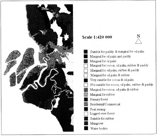
Figure 1: Agro-Land suitability Map South west Selangor
6. Conclusion
The study has made possible the potential application of integrated remote sensing and GIS technology for AEZ and agro-land suitability assessment. This augers well for the eventual operationalisation of this integration for agricultural planning and modeling in the spatial and temporal domains.
References
- FAO. 1996. Agro-ecological zoning- guidelines. FAO SOIL BULLETIN
- Mahmood. N. N. 1983, - The use of Satellite Remote Sensing Data for Agro-ecological Mapping of Penisular Malaysia