| GISdevelopment.net ---> AARS ---> ACRS 1997 ---> Poster Session 2 |
Remote Sensing Study for
Potash Exploration in Kohar Playa in the East of Iran
Simin Mehdizadeh
Tehrani-Aloreza Namadmallan
Geological survey of Iran's Remote Sensing Group
P.O.Box: 13185 -1494, Tehran-Iran
Abstract Geological survey of Iran's Remote Sensing Group
P.O.Box: 13185 -1494, Tehran-Iran
The necessity of achieving Potash resources for Producing chemical Fertilizer, has been caused that Program adaporators begin to start studying about its exploration and production form evaporated sediments and brines.
There are more than 60 small and big playas in Iran (Fig. 1). The biggest of them is great Kavir which extends 53000km2., with 37% salt crust. Khour salt crust in the west of Tabes with 2000km2 is one of the biggest salt crust of Great Kavir.
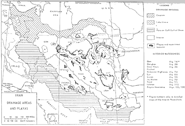
Figure 1: Relationship of playas to drainage areas in Iran.
Since it is difficult even impossible to do direst studies in these areas due to lack of access routes, it seams necessary to make use of remote sensing studies instead of desert survey. For this reason khour playa was chosen as a case study by using of special image processing methods such as contrast stretching, filtering, Principal component and color composite images. In this was we could obtan more information about the salt crust boundries, the rate of clay, charge drainage system and controlling factors, tectonic structure and the areas with the same debbi.
Introduction
The khour area is limited by altitude 55,20 to 55, 50 and longitude 33, 20 to 34, 20 N, a part of Great Kavir in Central Iran. The oldest rocks attributed to the upper Jurassic-Lower Cretaceous including shale & Sandstone and are overlain by the orbitolina limestone, less frequently by marl and sandstone of lower Cretaceous. These rocks are over by green-gray marl with interlayers of limestone, hale & marl of upper Cretaceous. The plaleocene represented by Plagic limestone. Lower, Eocene with red sandstone, conglomerate, mudstone, marl and limestone, is overlain by andesitic-dacitic lava with related tuffs. The small outcrops of Oligo-Miocene with unconformity represented by limestone, sandstone and Conglomerate. The upper Mocene included claystone, sandstone and frequently gypsinate. Pliocene represented by ocnglomerater and sandy clay.
Quaterney sediments consists of alluvial-Prolouvia pebble gravel & sand forming high, middle and low dashts, salinized clayey, sandsy clayey and salt crust.
Remote sensing Studies
The forest stages pf the Remote sensing studies was to choose two TM sub-cenes 93/12/1992, orbit 161) & (23/7/1988 orbit 161) that covered the whole area for selecting the enhancement techniques. After radiometric correction by using the scatter plot comparison of bands 1,2,3,4, to 7, the geometric correction based on topographic maps that carried out and ortho images of the area were produced.
After mosalicing the two images that covered the whole area, in order to achieve the optimized colour presentation of images that illustrate the salt crust and clayey boundaries, we should carefully choose the three channels for making colour composite images.
In this study the different enhancement techniques were used: such as contrast stretching, filtering, ration, Principal component and then the colour composite images were produced by co-registerated three bands display using RGB or HIS.
This images provided data about the salt crust and clayey boundaries, black salt, the moisture of the clays, the drainge systems and fans.
TM bands 1,7,4 were displayed as blue, red & green categoreze the clays according to their moisture and the variety of salts according to their clay contents.
Another images clarifies all the above mentioned chrematistics in different colors.
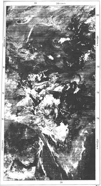
Figure 2: The Color Composite Image of Khour
Mean while there is a third images that has been prepared to shoe Isograde map.
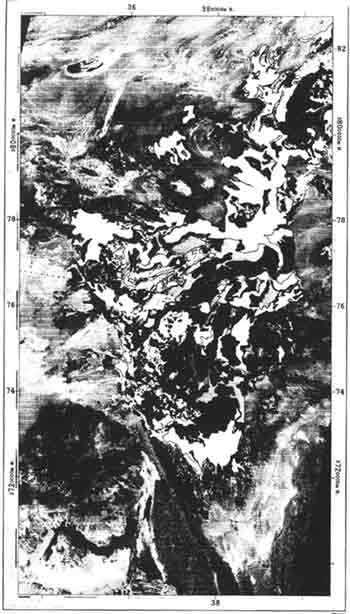
Figure 3: The Rock Units Map of Khour
Conclusion
On the base of there images it was detected that Khour salt crust could be divided in to three parts including northeast, Central and southwest.
- the northeast part located in west of Eshghabad. Salt crust distribution limited to some narrow and a relatively large outcrop salt crust which is charged by the east narrow drainage and is expected to be rather stable for salinity and grade of Potash. The comparison of recent Landsat images and Phothos of 1954 have shown that crust has been replaced by mud.
- the central part has the largest salt crust with more than
1000km2 widespread. A symmetrical delta fan has connected
seasonal water to salt crust. Due to turbulency which is well shown on
the images, the Potash brines is pumped and brakish water is replaced.
Therefore in this section pumping capacity and period is of major
importance for having an acceptable grade.
In south section this delta has minor effect and there is a constant grade.
The two white and black crust basins lie to the fan delta with polygonal cracks. Black salt crust expanded and cover lapped each other.
Occasionally black briney muds are extruded upward between the white polygonal salt plates.
Krinsly considered during the day, the desert sun heats and thermally expands the wet mud directly beneath the salt. Along the cracks, however the evaporation of the brine effectively lowers the temperature. The a Pressure gradient forces the Plastic briney form beneath the Center of the salt plates outward and upward through the peripheral cracks. The briney muds solidity into black salt dikes along the cracks.
The salinity differs when you are getting far from delta.
Landsat images have shown turbulency near delta fan. The rough surface features are sharpened by ht effects of the wind and rain. - southwestern part of salt crust separated by eolian sand dune. It seams that structural displacement caused primarily by drifting, then eolian immigrated along area. A big delta fan charges this salt crust and its salinity is not acceptable.
Reference
- krinsley, Daniel., (1970)- A Geomorphological and Paleoclimatoligical study of the playas of iran.