| GISdevelopment.net ---> AARS ---> ACRS 1997 ---> Poster Session 2 |
Detecting management
practices of improved grasslands using ERS-1 SAR data
Nobuyuki Mino, Genya Saito
and Shigeo Ogawa
National Institute of Agro-Environmental Sciences,
3-1-1 Kannondai, Tsukuba, Ibaraki 305 Japan
Tel : (81)-298-38-8225 Fax: (81)-298-38-8199
E-mail:minonobu@niaes.affrc.go.jp
Abstract National Institute of Agro-Environmental Sciences,
3-1-1 Kannondai, Tsukuba, Ibaraki 305 Japan
Tel : (81)-298-38-8225 Fax: (81)-298-38-8199
E-mail:minonobu@niaes.affrc.go.jp
The backscattering behavior of the improved grasslands is investigated with the ERS-1 SAR data of a dairy farming area in Japan. Our results show that renovated grasslands with high surface roughness have extremely high backscattering coefficient, whereas the others do not show such high coefficients. The SAR-derived grass renovation map using backscattering signatures is almost consistent with the results from Landsat TM data. Grass renovation is a very important procedure for improving grasslands productivity. In dairy farming areas where optical data often hindered, the success in monitoring grass renovation using ERS-1 SAR data is considered to be very useful.
Introduction
Many dairy farming regions are distributed in the northern part of Japan and are almost perennial cloud cover rather than in upland crop areas such as paddy fields. Although optical Remote Sensing is greatly useful for monitoring improved grasslands, temporal monitoring is very difficult because optical data are hard to acquire. Space borne SAR measurements overcome this limitation of optical sensing and are expected to e an alternative method for grassland monitoring. In this study, we discuss the capabilities of ERS-1 SAR and its usefulness in monitoring grasslands management practices.
Material and methods
1. Management practices of improved grasslands
Grass-renovation and grass mowing are major management practices of improved grasslands. Precise and wide-area monitoring of them greatly contribute to decision making in management strategies. Grass-renovation is one of the most effective methods to recover grassland productivity. This practice consists of ploughing and Remote Sensing-seeding, usually it is applied to older grasslands which can not be improved by fertilizer applications. Although agricultural experimental station suggests that it should be applied once per 7-8 years, frequent implement of grass-renovation methods does not occur. Because grass-age (years after grass-renovation) is one good measure of productivity, the renovated year is a very useful guide for various management practices. The timing of grass mowing is also important for obtaining nutrient rich grass production. Because total nutrient amount decreases after the heading stage, mowing just prior to the heading have been recommended. Recently, with an increased demand for high quality grass production, the mowing time has been shifted to optimize productivity. Thus, monitoring of the status of grass mowing leads to a better understanding of management practices. In this study, we aimed to identify those two management procedures, grass-renovation and grass mowing, using ERS-1 SAR data.
2. Approach
Figure 1 shows a flow chart of the data and processing steps used in this study. During the growing season, grasslands have a considerable amount of biomass, however both renovated and mown grasslands have no-biomass. Renovated and mown grasslands have great differences in ground surface conditions. Renovated grasslands are characterized by the presence of bare soil and high roughness due to ploughing. Whereas, mown grasslands have the accumulation of dead material and no-ploughing activities. These distinctive characteristics of grasslands can be identify using optical data. Data characteristics of the Landsat TM image of unmown, mown and renovated grasslands are shown in figure 2. Although figure 2 does not show data for grazing pastures, characteristics almost similar to unmown grasslands are shown. Identification of backscattering signatures of unmown, mown and renovated grasslands on ERS-1 SAR data can be made, using optical sensors and ERS-1 SAR data observed on the almost the same date. In this study, we asses the capability of ERS-1 SAR data to discriminate the three conditions of grasslands using the Landsat TM-ERS-1 SAR data pairs.
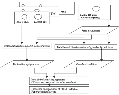
Figure1.Flow chart of the used data and processing steps in this study
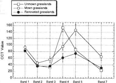
Figure 2. Landsat TM data (17 August 1995) signatures of mown, unmown and renovated grasslands.
3. Satellite data
For the analysis, Landsat TM and ERS-1 SAR data (Level 2.1) acquired during the growing seasons in 1994 and 1995 were used. ERS-1 SAR data were processed by NASDA (National Space Development Agency of Japan). The data are three-look precision images with pixel sizes of 12.5 m in both azimuth and range directions. The TM-SAR pairs for this study on backscattering signatures of grasslands are (1) TM (17 May 1994)-SAR (1 June 1994), and (2) TM (13 July 1994)-SAR (8 July 1994), and (3) TM (5 August 1994)-SAR (14 August 1994) and (4) TM (17 August 1995)- SAR (21 August 1995).
Results and discussion
1. Backscattering signatures of unmown, mown and renovated grasslands
The backscattering coefficients per field derived from ERS-1 SAR data for unmown, mown and renovated grasslands were shown in figures 3. An extremely high backscatter coefficient for renovated grasslands on all ERS-1 SAR data can be identified. Unmown and mown grasslands showed lower backscattering coefficient.
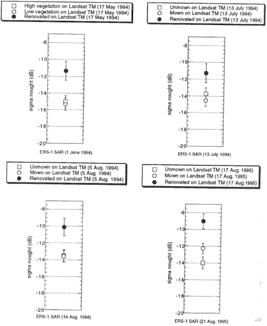
Figure 3. Backscattering signatures off unmown, mown and renovated grasslands on ERS-1 SAR data.
Renovated grasslands have bare soil surface. Their backscattering signatures are dominated by soil moisture and surface roughness (Major et. al. 1993). Increased backscatter from renovated treatment considered to be due partly to higher moisture content and partly to higher surface roughness. However, renovated grasslands never have extremely higher moisture contents rather than adjacent grasslands. Renovated grasslands have ground surfaces with high roughness due to ploughing approximately 25 cm in depth Unmown and mown grasslands do not have high surface roughness. Major et. al. (1993) and many other studies have suggested that ploughed bare soil was an important sources of scattering in agricultural fields. Thus, high backscattering coefficients in renovated grasslands were considered to be mainly due to the high roughness of the ground surface.
On the other hand, unmown and mown grasslands showed relatively low backscatter coefficients and have almost the same signatures. Although unmown grasslands covered by grass approximately have 100 cm in height in the growing season, canopies of small leaf crops such as grass was not a significant component for backscattering signatures in the C-band. Success in ERS-1 SAR monitoring of biomass change in sugar beet (Xu et. al. 1997) which radar backscatter results mainly from the vegetation and water has been reported. However, in Hoekman and Bouman (1993), among various crops, grass had the lowest backscatter in the C-band. Lin et al. (1994) reported that the presence of the short grass canopy does not have a significant effect on C-band backscattering signatures. In conclusion, identifying whether grass has been mown or not is still difficult using ERS-1 SAR in the C-band alone. Higher frequencies (X- and K-bands) should be used to monitor changes in grass biomass.
2. Detection of grass renovation in a growing season
Our results showed that renovated grasslands have extremely high backscatter coefficients compared to the others types. Accordingly, we tried to detect grass renovation practices in the study site through the growing season using multi-temporal ERS-1 SAR data.
Landsat TM sensors can early discern grass-renovated areas in the study site (see Figure 2). Frequent Landsat TM observation during the growing season made it possible to monitor grass renovation throughout the year. After grass renovation, grasslands are not productive. At least, in the first 1-2 months after grass renovation, there is little biomass on the ground surfaces of grasslands. In the study site where it was mainly cloudy, three Landsat TM images (17 May, 13 July and 5 August) fortunately available in the 1994.We produced grass-renovation reference map in the 1994 using these datasets.
For evaluation of the SAR-derived grass renovation map, these two renovation map, that is, TM-derived and SAR-derived map, were compared. Cross comparison between the Landsat TM-derived renovation map and the ERS-1 SAR - derived map were shown in table 1. A comparison showed that they were highly agreeable except for some areas. For instance, some mown grasslands were confused with renovated grasslands in ERS-1 SAR data. Mown grasslands have field surfaces with little biomass. Because mowing procedures were carried out using large-sized combines, this may result in wheel tracks on the fields. When the tracks were perpendicular to the incident microwaves, high backscattering occurred. The remaining stubble and grass stacked for drying on the fields may contribute to the mislabeled pixels. Additionally, some renovated grasslands were not identified in ERS-1 SAR data. Grass-renovation consists of ploughing and seeding. Just after ploughing, the soil was turned over into large clumps and it leads to high roughness in ground surfaces. However, after the compacting procedure, carried out using a land roller after seeding to prepare the soil, roughness become relatively low. They may result in some undetected areas of grass-renovation using the ERS-1 SAR data.
| TM-derived renovation map | SAR-derived renovation map | ||
| Renovated (fields) | Others (fields) | total (fields) | |
| Renovated | 45 | 5 | 50 |
| Mown | 4 | 26 | 30 |
| Unmown | 0 | 20 | 20 |
| Total | 100 | ||
In this study, we assessed the capabilities of ERS-1 SAR data to detect grass-renovation and grass mowing practices. Our results showed that renovated grasslands with high surface roughness have high backscattering coefficients. The SAR-derived grass renovation grasslands map using the backscattering signatures were almost consistent with the results from Landsat TM data. On the other hand, detection of grass mowing practices was still difficult using ERS-1 SAR alone. ERS-1 SAR was not necessarily suited for monitoring biomass of small leafy canopies such as grass, but better suit for high frequency systems. Grass renovation is a very important procedure for improving grasslands productivity, and temporal monitoring of grass renovation can contributable to various management strategies. In dairy farming areas where optical data often hindered, the success in monitoring grass renovation using ERS-1 SAR data is considered to be very useful.
References
- HOEKMAN, D.H. and BPOUMAN, B.A.M., 1993, Interpretation of C- and X-band radar images over an agricultural area, and Flevoland test site in the Agriscatt-87 campaign. International Journal of Remote Sensing, 14, 1577-1594.
- KUROSU, T., FUJITA, M. and CHIBA, K., 1995, monitoring of rice crop growth from space using ERS-1 C-band SAR. I.E.E.E. Transactions on Geosciences and Remote Sensing, 33, 1092-1096.
- LIN, D.S., WOOD, E.F., BEVEN, K. and SAATCHI, S., 1994, Soil moisture estimation over grass-covered areas using AIRSAR. International Journal of Remote Sensing, 15, 2323-2343.
- MAJOR, D. S., LARNEY, F.J., BRISCO, B., LINDWALL, C.W., and BROWN, R. J., 1993, Tillage effects on radar backscatter in southern Alberta. Canadian Journal of Remote Sensing, 19, 170-176.
- SCHOTTEN, C.G.J., W.W.L. VAN ROOY and L.L.F. JANSSEN., 1995, Assessment of the capabilities of multi-temporal ERS-1 SAR data to discriminate between agricultural crops. International Journal of Remote Sensing, 16, 2619-2637.
- TOAN, T. LE, RIBBES, F., WANG, L., FLOURY, N., DING, K.H., KONG, J.A., FUJITA, M. and KUROSU, T., 1997, Rice crop mapping and monitoring using ERS-1 data based on experiment and modelling results. I.E.E.E. Transactions on Geosciences and Remote Sensing, 35, 41-56.
- SU, H., STEVEN, M.D. and JAGGARD, K.W., 1996, Monitoring leaf area of sugar beet using ERS-1 SAR data. International Journal of Remote Sensing, 17, 3401-3410.