| GISdevelopment.net ---> AARS ---> ACRS 1997 ---> Poster Session 2 |
Satellite Monitoring of
Landside and Rapid Erosion in Southern Luzon: Contributors to Sediment
Deposition in the Lingayen Gulf, Northwestern Luzon, Philippines
Salvador,
J.H.G.1, Kanbara, H.2, Sato, T.2,
Machida, S.3, Hato, M.3, Almeda, R.1,
Gaerlan, S.3, Laserna, S.1 and Apil, F.W.
5
1Mines and Geosciences Boreau, North Ave., Diliman, QC, 1101 Philippines.
Fax (632)928-8544
2Nikko Exploration and Development, Condition., Ltd., 7-10 Toranomon
2-Chrome, Minatoku,Tokyo, Japan.
Fax(81)3-3508-9785
3Earth Remote Sensing Data Analysis Center,
Roppongi First Bldg., Tokyo, Japan
4Mines and Geosciences Bureau, Regional Office No. 1,
San Fernando, La Union, Philippiness
5Mines and Geosciences Bureau, Cordillera Administrative Region,
Baguio City, Philippines.
Abstract
1Mines and Geosciences Boreau, North Ave., Diliman, QC, 1101 Philippines.
Fax (632)928-8544
2Nikko Exploration and Development, Condition., Ltd., 7-10 Toranomon
2-Chrome, Minatoku,Tokyo, Japan.
Fax(81)3-3508-9785
3Earth Remote Sensing Data Analysis Center,
Roppongi First Bldg., Tokyo, Japan
4Mines and Geosciences Bureau, Regional Office No. 1,
San Fernando, La Union, Philippiness
5Mines and Geosciences Bureau, Cordillera Administrative Region,
Baguio City, Philippines.
Several satellite data such as Landsat MSS, Landsat TM and JERS-1 OPS from 1972 and 1973 covering Northern and Northwestern Luzon, Philippines were studied. Landslide and rapid erosion areas in northern Luzon were interpreted from the images and verified in the field.
The satellite images show that slope failures in northern Luzon have increased in recent years. Sedimentation of river systems also increased. These can be related to the effect of the 1990 Luzon Earthquake. Sediments from these processes eventually find their way into the Lingayen Gulf.
Introduction
The Lingayen Gulf area in northern Luzon is part of the Philippines Northwestern Luzon Growth Quadrangle. The area is characterized by rapid population growth and expansion of urban centers. This growth changes the land cover and puts a strain on the available resources of the area.
At the same time, the area's geoenvironmental condition is changing. The 1990 Luzon earthquake caused slope failures. This couples with strong typhoons hastened the sediment erosion and deposition process. The sediments find their way to the Pangasinan lowlands and eventually into the Lingayen Gulf, both major sources of livelihood in northwestern Luzon. This study aims to monitor the sources of sediments from 1972 to 1994 using Remote Sensing technology. The results will be an input into the region's development plan.
The Agno River is the largest river flowing into the Lingayen Gulf. The total length of the river is about the mountain areas east of Itogon Province characterized by deep valleys and rugged topography. It then flows through the lowlands of Pangasinan before emptying to the Lingayen Gulf in the west.
The vicinity of Itogon Province is considered to be an area where mass movement or the possibility of it occurring is high (DENR and NEDA, 1994).
Methodology
Several satellite images were obtained. Table 1 shows the shows the summary of the images used. A regional geological interpretation was made on the 1993 TM image to determine the geological and geomorphological boundaries and the lineament zones. A photo geomorphological interpretation map of the Agno River Basin with special emphasis on identifying landslide concavities was also made (Fig. 1). A maximum likelihood classification was applied to the 1988 and 1993 TM images to identify open area, soil, weathered areas or barren ground areas before and after the July 1990 earthquake. Figure 2 shows the identified barren ground areas (color green) in the two dates. A photogeological interpretation was made on the 1972 to 1993 images to monitor the extent of flood deposits in the Agno River Basin.
| Data | Path/Row | Acquisition Date |
| Landsat MSS | 125/49 | 18 November 1972 |
| Landsat MSS | 125/49 | 10 May 1976 |
| Landsat MSS | 125/49 | 21 February 1979 |
| Landsat TM | 116/49 | 31 January 1988 |
| Landsat TM | 116/49 | 03 December 1989 |
| Landsat TM | 116/49 | 02 April 1993 |
| JERS-1 OPS | 91/273, 274 | 06 November 1993 |
| JERS-1 SAR | 91/273, 274 | 07 May 1993 |
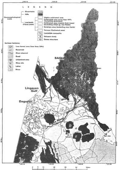
Figure 1-Photogeomorphological interpretation map of the Agno River Basin with special emphasis on identifying landslide concavities.
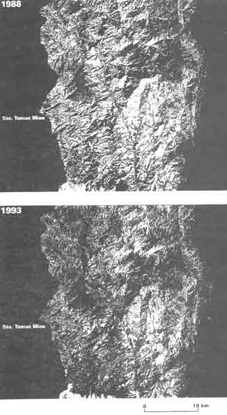
Figure 2 -The 1988 and 1993 Landsat TM images after application of the maximum likelihood classifier to show the extent of open areas, soil, weathered areas or barren ground areas before and the July 1990 earthquake. 'The identified barren ground areas are colored green.
Results and Discussion
The regional geological interpretation shows that landslide occurs in several areas irrespectively of seemingly high resistance or medium resistance rocks. Figure 1 shows that most landslides occur mostly in mountains or high relief areas, irrespective of lithology. Figures 2 shows that aerial extent of barren ground areas (colored green). The distribution of this barren ground is on mountainous areas near drainage systems making it reasonable to believe that these are landslide areas. The classification statistics show that barren ground areas increased from 2.7 km2 in 1988 to 5.6 km2 in 1993 after the earthquake. Sediments from these areas will find themselves mostly in the Agno River System that will empty in the Lingayen Gulf.
Coarse sediments flowing down the river systems are deposited as alluvial fans and floodplain deposits. The chronological changes in the distribution of these sediments flowing down along the Agno River System were examined from the 1972 to 1993 images. The analysis shows a high sediment deposition in 1972 than in any other year. The precipitation data from the US National Oceanic and Atmospheric Administration (1970 to 1980) and the Japan Meteorological Agency (1981 to 1994) measured in Dagupan show a high 2,659 mm monthly rainfall in July 1972. This shows that high rainfall contributes to high sediment deposition along river beds.
The field survey in 1995 shows that the height of the river bed upstream of the Agno River rose by about 1.5 meters. The same field survey shows that the back of the Ambuklao and Binga Dams were heavily silted. Personal communication with geologists from the Cordillera Administration Region states that this high sedimentation occurred after the July 1990 earthquake.
Conclusion
The foregoing results and discussions show that slope failures and sedimentation of river systems can be monitored by satellite systems. Slope failures in northern Luzon have increased in recent years. Sedimentation of river systems also increased. These phenomena can be related to the effect of the 1990 Luzon Earthquake. High rainfall is also a factor especially in increased sedimentation. The sediments from these two processes find their way into the Agno River and eventually to the sea, thus contributing to the sedimentation of the Lingayen Gulf.
References
- Department of Natural Resources and the National Economic Development Authority, 1994. Identification of sources of Siltation Affecting the Major River Systems of Regions I, 76pp.
- US National Oceanic and Atmospheric Administration Monthly Precipitation Report from 1970 to 1980.
- Japan Meteorological Agency Monthly Precipitation report from 1981 to 1994.