| GISdevelopment.net ---> AARS ---> ACRS 1997 ---> Poster Session 2 |
Surface Temperatrue Rerieeval
from Satellite Data Over South China sea
Shattri, B.Manosr, Quazi
Halid Hasan, Abd Rehman Ramli
Faculty of Engineering
University Putra Malaysia
43400 UPM Serdang, Seldang , Selangor, Malaysia
Tel : 609-6175135; Fax: 609-6175136
E-mail:shattri@rs.eng.upm.edu.my
abstract Faculty of Engineering
University Putra Malaysia
43400 UPM Serdang, Seldang , Selangor, Malaysia
Tel : 609-6175135; Fax: 609-6175136
E-mail:shattri@rs.eng.upm.edu.my
NOAA AVHRR data is widely used in monitoring and manager of natural resources specifically oceanographic features from space. a near real time observation and management system has been developed utilizing remotely sensed data.
For geocoding of ht satellite images, an orbital model has been used of relating the geographic position ( latitude/longitude ) with the image elements ( row/column ). The retrieval of sea surface temperature from NOAA data is the most improvement object for the above mentioned objectives. The algorithms based on radioactive transfer equations was used to extract sea surface temperature. Two model s namely I) single channel and ii) split window approach are developed and the coefficients of the models can be obtained from radiosonde data. For split window approach, AVHRR channel 4 & 5 data has been used. The comparison between the estimated SST and ground data over south China sea are discussed. The developed models was customized in EAST environment and can used for fish forecasting and monitoring of oil spill over Malaysian sea water.
Introduction
Satellite images navigation is a task of locating latitude/longitude with any point interms of line/row in the image. for the image navigation, many researchers ( Brush, 1988; Ho and Assem, 1986; Emery et al., 1989) pointed out a number of model with different approaches. Actually the Earth is not perfect sphere but elliptical with a small degree of eccentricity and spherical Earth shape can be used to avoid more complexity and to get accuracy in the orbital modeling (Illera et al., 1996).
In the past , a number of irradiative transfer models have been developed to correct for the effect of atmospheric attenuation on remotely-sensed data. A larger amount of work as already been undertaken and successful results have been obtained using three methods, namely a single infrared channel method ( Djavadi and Anderson, 1987), a multi-channel ( split window ) method ( Parabhakara et al., 1974) and a multi-angel method ( hoyler, 1984).
The objective of this study is to develop near real time system for fish forecasting and monitoring of oil spill. The uncertainty of he proposed physical model of orbital navigation and the measurement of sea surface temperature are determined to fulfill the objectives. Finally, the use of the model for georeferencing of the image and estimate sea surface temperature over south China sea is presented.
Modeling approaches
Orbit model
Fig .1, represents the orbital model. Here the assumption is the spherical earth and circular satellite orbit. The relation in between geographical position ( latitude/longitude ) and coordinates of the acquired image ( line/pixel ) is as (10.
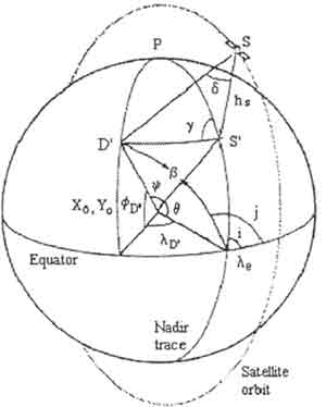
Fig 1. satellite orbit geometry : I, hs g, d, le, ld., fD., Xo, Yo are inclination, height azimuth angle, off-nadir view angle, equator crossing longitude, longitude reference to ascending node, latitude reference to ascending node and image dimension respectively.
This model was described by Ho and Assem ( 1986) and successfully implemented by many researchers ( Emery et al., 1989.; Illera et al., 1996).
The equator crossing longitude and the time interval are calculated using geographic coordinates and measured in the images from a control point [8]. The satellite inclination, height, scan start time can be found from satellite operational agencies and header of the image file respectively.
Sea Surface Temperature Model
Single Channel Method
This model describes a single infrared channel method to retrieve surface temperature from space ( Masor and Embi , 1996). The model follows a relationship as (2).
| Ts=[ | Tib ------------ Îi ti |
- | Tab kiW ---------- Îi ti cos q |
- | 2(1-Îi) ------------ Îi |
TabkiW]1/b (2) |
Where Ts sea surface temperature to be calculated , Ti brightness of i channel, Ta atmospheric temperature, Ki absorption coefficient of the atmosphere, Îi emissivity, ti transmittance, q zenith angle, W total amount of water vapor, b least squares fitting coefficient.
The unknown variables of the above modeling expression can be determined form radiosonde profiles or from historical data. For this model 10.5-12.5mm spectral channel data of any satellite can be used to get surface temperature from space.
Split Window Method
This model uses two adjacent channels to retrieve the surface temperature. The model ( sorbrino et al ., 1991) is as follows .
Where, To is surface temperature, T1 and T2 are respectively the radiometric temperatures in tow adjacent channel of 11 an 13 mm, A and B are coefficients which depend on the surface emissivities, atmospheric absorption coefficients and total vapour amount as (4) & (5).
B=((1-Î1) a1b1 (1-2k1 W) L1/ Î1Q)- ((1-Î2) a2b1 ( 1-2k2 W) L2/Î2Q) (5)
Where, ai = Îi ti cosq, bi = ki [1+2 ti (1-Îi) cosÎ], and Q = a1b2- a2b1. the unknown variables are of same meaning like single channel method and the values are found as the same manner as in single channel method.
Study area and data used
The study area in south china sea from 1030E to 1100E longitude and 10N to 70N latitude approximately. The survey map at scale 1:760,000 including peninsular Malaysia and South China sea has been used for geocoding the images.
NOAA-14 AVHRR data of April 1996 and the corresponding radiosonde data has been used to estimate .
Results and discussion
The orbital model has been used to correct NOAA-14 AVHRR image corresponding to April 21, 1996 with 1024 lines by 1024 columns. The standard deviations between the coordinates measured in the images and those calculated by means of the orbital model range form 2 to 6 pixels. In order to minimize the misregistration , the ground control points fitting has been implemented.
In between the tow methods of surface temperature estimation, the split window method is more accurate than single channel method to estimate the sea surface temperature. The sea surface temperature models were implemented on NOAA AVHRR data. the sea surface data has been compared with the extracted SST values form NOAA-14 AVHRR imageries. The SST is shown in fig .2.
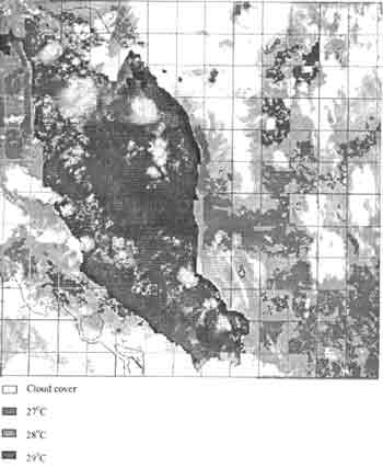
Figure 2: Sea surface temperature from split window method (NOAA-14 AVHRR April 21, 1996) GMT 7:16
Conclusion
An integration of orbital model and GCPs collection method has been implemented for geocoding of NOAA AVHRR images. Were conclude that this type of algorithm is adequate for locating fishing zones. The main restriction of this procedure is the availability of images that are cloud free to make possible use of ground control points.
Finally, a near real time fish forecasting system has been developed. Current works involve correlating the estimated SST with the fishing zone, on line access of AVHRR data from SEAFDEC Ground Receiving Station, Terengganu and development of Fish forecasting website.
Acknowledgement
The authors would like to thank SEADEC, Terengannu for supplying NOAA AVHRR and sea truth data.
Reference:
- Bachmann, M. and Bendix, J., 1992, ' An improved algorithm for NOAA AVHRR image referencing " International Journal of Remote sensing, 13, 3205-3215.
- Brush, R.J.H., 1988, " The navigation of AVHRR imagery", international journal of Remote Sensing, 9, 1491-1502.
- Djavadi, D., and Anderson, J.M., 1987, " Atmoshperic correction of infrared data using multi-height data acquisition", international Journal of Remote sensing., 8, 1879-1884.
- Emery, W.J., Brown, J., and Nowak, Z.P., 1989, " AVHRR images navigation; summery and review", Photogrammetric Engineering and Remote sensing, 55, 1175-1183.
- Ho, D., and Assem, A., 1986, NOAA AVHRR images referencing", International Journal of Remote sensing, 7, 895-904.
- Holyer, R.j., 198, " A two satellite method for measurement of the sea surface temperature", International Journal of Remote sensing, 5, 115-131.
- Illera, P., Delgado, J.A. and Calle, A., 1996, " A navigation algorithm for satellite images', international Journal sensing, 17, 577-588.
- Mansor, S.B. and EMBI, A.F., 1996, " Tropical model for retrieving surface temperature from TM data and its relevance to the study of hydrology of small islands", paper presented data the 17th Asian conference on remote sensing, Colombo, Sri Lanka, 4-8 Nov.
- Prabhakara , C., Dalu, G., and Kunde , V.G., 1974, " Estimation of sea surface temperature from Remote sensing in the 11 and 13mm window region', journal of geophysical research's, 79, 5039-5044.
- Sorbrino, J.A.., Col, C., and Caselles, V., 1991 " Atmospheric correction for land surface temperature using NOAA- 11 AVHRR channels 4 and 5". Remote sensing of Environment, 38, 19-34.