| GISdevelopment.net ---> AARS ---> ACRS 1997 ---> Poster Session 1 |
Mapping and Monitoring of
Natural Resources of Kanjli Wetland Ecosystem (Punjab) India-An Integrated
Approach for its Conservation.
V.K.Verma, Rajiv Chopra and
P.K. Sharma
Punjab Remote Sensing Centre, Ludhiana-141004
Abstract Punjab Remote Sensing Centre, Ludhiana-141004
The Ramsar Convention of IUCN help in 1971in lran raised global attention on conservation and management of wetlands. The importances of wetlands have been recognized recently in India. The Ministry of Environment and Forests, Govt. of India has identified 17 'Notified Wetlands' for their conservation and management and Kanjli wetland (Kapurthala District) in Punjab is one of them. To have an integrated, environmentally compatible approach for conservation of this wetland an attempt has been made to map landuse, water spread and vegetation and to asses the water quality in terms of its turbidity under 'National Wetland Mapping Project' funded by Ministry of Environment and Forests, Govt. of India. Various thematic maps have been prepared using pre and post monsoon IRS 1A LISS II(FCC) generated from bands 2,3and 4. Five major landuse categories viz., built up land, agricultural land, forest, wasteland and wetland were identified and mapped. These were father subdivided into subclasses and their respective areas were computed. The water spread of the lake for post monsoon and pre-monsoon has been mapped. The qualitative turbidity as manifested on the false colour composites has also been assessed. Based on these maps, the thetas to Kanjili wetland has been identified and adequate conservation measures have also been suggested.
Introducation
India by virtue of its extensive geographical stretch and varied terrain and climate, supports a rich diversity of inland and coastal wetland ecosystems. As per Directory of Wetlands (1988), in India a total area of 40494 sq. km. is classified as wetlands. This forms only1.21% of the total land surface. This directory also includes 14 wetlands of Punjab covering 225.76 sq. km area out of total 5.357 sq. km of the geographical area of the State. The ministry of Environment and Forest, Govt. of India has identified 17 notified wetlands including Harike, Ropar and Kanjli of Punjab for their conservation and management. In view of this an attempt has been made to map landuse, water spread and vegetation and to assess the water quality in terms of its turbidity, under National Wetland Mapping Project funded by Ministry of Environment andForest, Govt. of India.
Study Area
Kanjli wetland is located about 4 km from the city of Kapurthala on the West or Black Bein (Fig.1). Kanjli lake came into existence as a result of small irrigation barrage built at Black Bein. It is a man made fresh water riverine system. Kanjli ecological region stretches around villege Kanjli in Kapurthala district. It can be classified as both natural as well as artificial wetland. Natural, because it had been a part of riparian ecosystem had at that time immemorial. It had the natural flora just as the other part of river ecosystem and at that time. It gained artificiality with the construction of the barrage resulting in the impoundment of water.
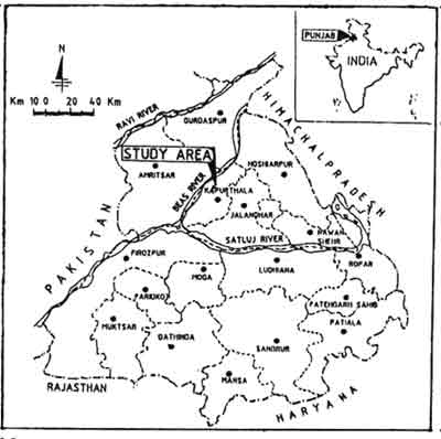
Figure 1: Location Map of Study Area
Methodology
The landuse/land cover map of Kanjli wetland and its environs was prepared through visual interpretation of IRS-IA LISS-II multidate data ( pre monsoon- March 1993 and post monsoon- October 1992) in the form of false colour composites (FCC) generated from bands 2,3and 4 following the landuse classification system proposed by Space Applications Centre, Ahmedabad. The variation in tone, texture, size and shape were used to identify and map different landuse classes and sub classes. Permanent features like major settlements, roads and canals were traced from Survey of India maps. Per monsoon and post monsoon satellite data was Kanjli lake has also been recorded. The qualitative turbidity ratings viz. low, moderate and high were assigned based on the hue, as manifested on the false colour composites.
Results and Discussion
Five major landuse categories viz. built up land agricultural land ( crop land, plantation etc.), forests, wasteland and wetland were identified and mapped (Fig.2). These were further subdivided into sub classes and their areas computed (Table 1). The perusal of the data in table 1 indicates that out of 5150 ha area, 209 ha is covered by swamp/marsh and 779 ha is waterlogged (seasonal). The lakes/ponds cover 9.5 ha whereas 29 ha area is covered by oxbow lakes or cut off meanders. The area under wastelands comes out to be 559 ha. Nearly 123 ha area is under various types of forests. Corp land (double crop) constitute 3082 ha area, in addition seasonally water logged area of 779 ha is also utilized for paddy cultivation. Plantations and built up land cover 66 ha and 281 ha area respectively.
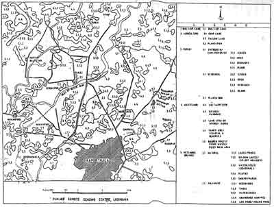
Figure 2: Location/Land Cover Map of Kanjli Wetland
| Map Symbol | Landuse category | Area (ha) |
| 1.1 | Built up land | 280.8 |
| 2.1 | Crop land (double) | 3082.5 |
| 2.2. | Fallow land | 2.1 |
| 2.3 | Plantation | 66.3 |
| 3.1 | Forest | 122.4 |
| 4.1 | Salt affected | 71.9 |
| 4.3 | Land with or Without scrub | 61.0 |
| 4.4 | Sandy area | 436.0 |
| 5.1.1 | Lakes/ponds | 9.5 |
| 5.1.2 | Ox bow lakes/cut off meanders | 29.0 |
| 5.1.3 | Water logged seasonal | 779.0 |
| 5.1.5 | swamp/ Marsh | 209.5 |
| Total | 5150.0 |
Turbidity
In this study qualitative turibidity of Kanji lake has recorded based on the hue as manifested of false colour composite for pre and post monsoon seasons of 1992 an d1993
The turbidity classification is based on system proposed by SAC, Ahmedabad (Table 2)
| Turbidity level | Map symbol | Hue on FCC |
| Low | L | Dark blue |
| Moderate | M | Medium blue |
| High | H | Light blue/Whitish blue |
The study revealed that Kanjli Lake qualifies for low turbidity class during pre monsoon and moderate turbidity class during post monsoon season indicating the regimentation of the lake during post monsoon season
Monitoring of Water Spread
The water spread an turb8dity for pre and post monsoon season has also been monitored. The study reveals that post monsoon extent of Kanjli lake was 3.79 ha where as pre monsoon spread was 3.50 ha. The water spread in the post monsoon season is more because it receives rain water from BlackBein and many seasonal rivulets coming down from Siwalik hills. During monsoon, the flow of Black Bein is considerable and many a times it overflows its banks. The area abounds number of abandoned channels which mostly get activated during monsoon. Most of the torrents end up in shallow depressions. Disposition of these depressions along the river Beas are indicative of old abandoned beds of Beas. Extensive growth of water hyacinth has been observed during both the seasons which is posing big problem to the ecological status of the Knajli lake.
Threasts to Kanjli Wetland
Immediate and long term dangers to the wetland have been identified and these include anthropogenic pressure, weed infestation, europhcation, fishing and pesticide pollution. The most important threat to the wetland is due to the anthropogenic pressure i.3. indiscriminate conversion of wetlands for agriculture, human habitation, industrial expansion and recreational activities. There has been growing encroachment in the Kanjli wetland in the near past. About 7.34 ha area of this wetland which was encroached upon has been got vacated by district administration (ladhar, 1993). Extensive growth of water hyacinth is posing a big problem to the ecological status of Kanjli lake as it detracts the migratory avifauna and has replaced the natural aquatic floral and faunal components. In addition to water hyacinth, certain submerged and rooted weeds have become problematic in this lake. It is difficult and perhaps inappropriate to bring these water weeds under control, because it can create disruption in food chain structure. Their insitu decay add to the eutrophication of lake. The enormous development of water hyacinth and chemical characteristics of the lake water indicate pllution threat to the habitat. The pollution is the result of the wash down of nutrients and pesticides from adjoining agricultural fields. Illegal fishing, which continue by day and night through out the year, causes considerable disturbance to birds lie and reduces number of fish in the lake.
Conservation and Management
Various activities for proper conservation and management of Kanjli wetland have been going on since 1987. Punjab State Council for Science and Technology has been acting as a nodal agency for coordination of various activities. The detailed survey of Kanjli, wetland area is being undertaken by the Department of Town and Country Planning.
Water hyacinth has been the main threat to Kanjli wetland. Main problem is its consistently fast growth and its in situ death and decay.An integrated approach has been adopted to bring it under control by applying manual and biological methods but not chemical methods. Manually removed weed is being utilized for production of biogas at Kanjli. In order to prevent movement of this weed into wider stretches of kanjli lake and ofr its easy removal at one place, a "log boom" was installed by Punjab Irrigation Department. But the log boom gave way due to high pressure exerted by rain water during 1993 monsoons. Thus, the same has been dismantled by Irrigation Department, as verified by the authors during their recent visit to Kanjli. In additon to water hyacinth, certain submerged and rooted weeds also prose problem inKanjli lake. Many of the fish and bird species survive on these aquatic weeds. If these are eradicated it can create a disruption in food chain structure.
Apart from providing fuel, fodder and fruit, trees also help in maintaining the ecological balance in the wtland. About 10 ha area of Kanjli wetland has been brought under native tree plantation by the Forest Department, Punjab. Emphasis still needs to be laid in future on extensive plantation in areas especially less prone to floods. Plantation of some exotic tree species may require studies keeping in view the preference of migratory birds visiting these wetlands.
To tackle the problem of grazing and encroachment, fencing is necessary. To protect out already endangered ecosystems, fencing of certain strategic areas has been undertaken by the Forest and Wildlife Department, Punjab. Also there is a need of soil conservation in and outside the wetland area. The research studies to analyses the biotic components, food chain sequence and potential threats should be taken up to make long term conservation strategies. Integrated wetland management which can benefit both man and animal and at the same time maintain the ecological balance is the need of the hour.
The long term solution to the problem of protecting wetlands lies in education people. Unless people realize the need to safeguard wetland ecosystems and are aware of how they can contribute to this effort, there is little hope for the survival of these ecologically valuable and vulnerable habitat.
Acknowledgeemnts
The authors are thankful to Ministry of Environment and forests, Govt.of India for providing funds for this project. Authors also wish to thank Dr. Baldev Sahai, Former Deputy Directory & mission Director, RSAM and Sh J.K. Garg, Space Applications Centre (ISRO) Ahmedabad for their supervision and guidance to accomplish this project.
Reference
- Anonymous (1988). Directory of Wetlands in India, Ministry of Environment and Forests, new Delhi.
- Ladhar, S.S. (1993). Current Status and Trends in Wetland Ecosystems - Punjab Scenario. In Wetlands, their Conservation and management pp, 161-175.