| GISdevelopment.net ---> AARS ---> ACRS 1997 ---> Poster Session 1 |
Development of Automatic
Composite Processing System for NOAA/AVHRR GAC data
Shinya Suzuki and Yoshiaki
Honda and Kiji Kajiwara
Center for Environment Remote sensing center ( CEReS) ,
University of Chiba, Japan
1-33, Yoyoi, Image-ku Chiba 263, Japan
Tel: (81) -43-290-3945 FAX : (81) -43-290-3857
Abstract Center for Environment Remote sensing center ( CEReS) ,
University of Chiba, Japan
1-33, Yoyoi, Image-ku Chiba 263, Japan
Tel: (81) -43-290-3945 FAX : (81) -43-290-3857
NOAA/AVHRR GAC data which is collected for more than ten years is very useful for studies related to analysis of the global environment. In order to create mapped and composite data applicable for land term time series analysis, however, it is required that develop the system for automatic mapping and composite process. With interactive processing , it is impossible to create long term time series composite data because more than 4500 paths data should be processed for only one year data.
Authors have developed the prototype of automatic processing system which consist of following procedure. 1) cloud screening in day time 2) Automatic selection of GCPs . 3) Automatic GCP matching procedure. 4) Map one day paths to 4 km resolution longitude/latitude coordination . 5) in days composite procedure considering sensor scan angle, solar zenith angle.
Introduction
It is very important to understand the global environment that are getting worse recently. Therefore, the data of NOAA?AVHRR GAC is very important for analysis of the global environment.
For this property, the study related to development of the data processing algorithm used NOAA/AVHRR GAC data has been done frequently. But most of them has been simply in the process sing algorithm course of a low spec computer. At the data processing has need of manual works. In the present, however, for the development of computer technology had made possible speedy calculation and to make a high quality data.
Then we try to make automatic processing system which is possible to make a huge amount of high quality data from NOAA GAC.
Outline of data processing
The purpose of our data processing system which make n days composite data by the raw data of NOAA/AVHRR GAC will has been made automatically. In this case, difficult problem is to make selection of GCPs and GCP matching procedure automatically. We show this outline following. ( fig 1)
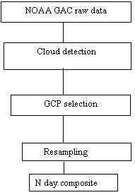
Figure 1: Outline of data processing
At the first processing is simply day time cloud screening for GCP hatching procedure. Next processing is geometric correction using automatic GCPL matching. The resampling user in geometric correction is method of using the corrected orbital elements ( Hashimoto and Murai 1993). Next one is to map one day paths. And last one is n days composite. Now we have made as far as geometric correction automatically. We will explain about cloud screening and geometric correction using GCP.
Cloud screening
This cloud detection scheme is to apply to one way procedure to detect t cloud. In this study, the purpose of making this procedure is to apply to selection of GCPs . therefore, this procedure is applied during the day time and sing channel 1 thresholding. in the channel 1 is corrected by cos q . q is the appropriate solar zenith angle.
Automatic selection of GCPs
At the path mapping, it is necessary to secret GCP point by path . but we success to make this process automatically by using the GCP ID number plotted image and the swath region image. they are given as follows. ( Figure 2).
Figure 2: Automatic selection of GCPs.
1) GCP ID number ploted image
GCP each have ID number. And the number was made by ploting ID number on the image. This image size is same of latitude/longitude grid system.
2) Swath region image. this image was made of latitude/longitude at the start and end of swath . they are included in the line header of GAC raw data. For such information. It is possible to make a swath reign image .
the method to select GCPs is shown in figure 2. the purpose of this way is to make a GCP ID number list which is used automatic GCP matching procedure. Therefore, you should compare GCP ID number plated image and swath region image. the comparing is done pixcel by pixcel, if a pixcel count on the swath region is true and a pixcel on the GCPL ploted image has count of ID number , GCP ID number is outputted to the file of the GCP ID number list.
Automatic GCP matching
The purpose of making this procedure is to search for the GCPs position on the raw data. The detail of this procedure is shown in figure 3. when we are used this procedure, it is necessary to use GCP library. There are about, 1,300 point of GCP information in library. It is consists of sea and land binary image files made by DCW ( digital chart of the world ) and longitude/latitude of GCPs. This library has about 1,300 small binary images around GCPs. The library has about 1,300 binary images around GCP with the information of their coordination.
Figure 3. Automatic GCP matching
At first, the small image of around GCP is cut out form satellite images and distinguished sea and land form channel 1 and 2 using NDVI thresholding. And make it binary of 0 or 1.0 means sea, 1 do land . it is size 51x51 pixcel. Finery, do template matching the cutted binary image made by raw data and the based binary image made by DCW is searched form GCP library. The size of DCW based binary image is 25x 25 pixel. A result of matching is the position of GCP on the raw3 data and a correlation coefficient. If the correlation coefficient is low, the position of GCP isn't adopted. In the case of high coefficient, we get the position of GCP on the raw data.
Conclusion
Cloud screening procedure in this study is for using automatic selection of GCPs. But this party is able to change improved cloud screening algorithm. Now this is only applied in the day time, but we will develop it for the purpose of appling to the night time. And we will produce the cloud screening map on the global scale.
On the procedure of selection of GCPs, it was successful to make automatically.
The automatic GCP matching is successful to make automatically.
Our purpose is that these procedure, cloud screening, geometric correction using GCP, mapping day path and n day composite make automatically. This work have completed include geometric correction.
Acknowledgement
Authors express or gratitude to Dr. Hashimoto for his advicing related to geometric correction of GAC data and his supplement of computer code of the resampling software.
Reference:
- T.Hashimoto nad S.Murai, 1993, Geometric correction of NOAA AVHRR imagery in accordance with the number of GCPs Journal of the Japan Society of Photogrammetry and Remote sensing , 13.