| GISdevelopment.net ---> AARS ---> ACRS 1997 ---> Poster Session 1 |
The Development of mutual
utilize system which share GPS camera Image to make use through the
internet
Shinya Suzuki and Yoshiaki
Honda and Kiji Kajiwara
Center for Environment Remote sensing center ( CEReS) ,
University of Chiba, Japan
1-33, Yoyoi, Image-ku Chiba 263, Japan
Tel: (81) -43-290-3945 FAX : (81) -43-290-3857
1. Introduction Center for Environment Remote sensing center ( CEReS) ,
University of Chiba, Japan
1-33, Yoyoi, Image-ku Chiba 263, Japan
Tel: (81) -43-290-3945 FAX : (81) -43-290-3857
GPS camera which can automatically record time and geographic information on the film has high utility value for collecting ground truth data. to build the database by using information which recorded on film will lead to development of GPS camera data for study. At the same time, utilization of GPS camera data leads to make standard data. in the other words, increase in these GPS camera image leads a standardization of save format of the GPS camera image and geographic data.
Recently, as the diffusion rate of personal computer increase, world Wide Web ( using internet ) increase. At the same time we are can open and browse data ( document and images ) by using Web sever and internet browser ( ex. Netscape Navigator ) . Moreover development of WWW technology is growing, it has just started to distribute interactive pages in cooperation with Web sever and database management system ( DBMS).
Therefore, in this study, for doing mutual use of resource ( ex. Images taken by GPS camera), it is method to develop network system that available to share GPS camera images by using internet and now we call that system" Global Image Network ( GIN)" .
2. Global Image Network ( GIN) Project
at first thought that it is necessary to gather meta data of GPS camera image in one place for sharing them globally and providing retrieval service. It was for that purpose that we are carrying study ( develop system by using internet ) forward. We call that system " Global Image Network ( GIN)" project. Were are now on the development and when it completes, GIN will contribute to the research activity in the field of Remote sensing and others.
Figure .1 shows three constituent of GIN, Meta data center, Local Data center, GIN user.
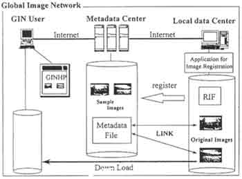
Figure 1:
Meta data center is most important center in GIN project, it offers some convenient service. It manage catalogue information (=meta data ) which registered form Local Data center and provide retrieval service thorough the GIN home page on WWW.
Local data center is organization which permitted to register GPS camera image to GIN through internet. Local data center is necessary to be necessary to be authorized by Meta data center. GIN users are users who access to GIN home page through the optional Web browser and get retrieval services.
More detail definitions of each constituent are follows.
A). Meta data center
Meta data center which is center constituent of GIN project is established on computer ( named GIN) in center for Environment Remote sensing Center ( CEReS0. it has main functions as follows.
- Management of Metadata
meta data center manage meta data concerning GPS camera image registered. It has URL of each GPS camera image, but it don't have any image. WWW technology has LINK function ( use URL) . meta data center is able to manage a lot of GPS camera images by using that function, so it doesn't need a mount of hard disk drives volume. We use SQL sever ( Microsoft ) as database.
- Authorization of Local data center.
Meta data center authorize local data center. In the case of authorization request form organization, Meta data center publish local data center account and password after examination.
- Management of registered user
meta data center publish account to registered user ( belong to Local data center ) on GIN home page.
- data search service
meta data center open catalog data ( registered image and data ) on GIN home page, and its offers home page for search data. by means of that, GIN user can search and download GPS camera image.
Local data center in necessary to have the minimum system for being authorized form Meta data center.
Local data center needs the following lists.
Local data center needs
- windows NT server ( ver 3.51 later )
- web server
- original image
original image keeps on Local data center server and registered user has its ownership . image size isn't fixed.
- thumbanail image.
thumbanail keeps on Meta data center sever and is used on GIN home page as catalog image. image size is fixed. If registered user want to register image, he has to prepare and send it to Meta data center .
GPS camera original images are placed on Local data center sever machine, dividing in to tow kinds of permissions .
- Full open data
open original image to everyone through GIN
- Conditional open data
open only meta data to everyone through GI. If someone wants this image, owner opens original image to him conditionally. Meta data center intermediates between the two sides.
Registered user must belong to Local data center, they are permitted by Local data center registers GLPS camera image by using Application for image Registered ( AIR), and he have to decide the permission for each image.
D). GIN user
If someone has the following system, he can access to GIN home page and download GPS camera image somewhere and every time.
GIN user needs
- internet connect system ( personal computer, modem, etc)
- web browser ( Netscap Navigator, Internet Explorer, MOSAIC, etc. )
at first, we builded the data base on the Meta data machine . when we built it, we utilize relational model. The second, we connected database to WWW sever, so we can open the data through the internet. The third, we developed AIR which creates Registration Information File ( RIF). RIF is the key file to transport data between Meta data center and Local data center.
Registration information File ( RIF)
RIF is described information of Local data center and registered user and registered image it ahs kept on each registered user of personal directory on Local data server . When registered users want to register or update image, this file is used. Registered users have to tell to Meta data center when he modify contents of RIF to Meta data center database. It has prescribed format, and must be written by ASCII code. Summary of prescribed format is following.
- RIF is divided into three block.
- header section ( local data center info , personal registered user info )
- group info section (meta data of group info)
- image info section ( each registered image info )
- Each element is separated by TAB code ( 0x09)
Sample RIF written by prescribed format is published at the back of this paper if RIF is written by prescribed format, registered user don't need to use AIR. But they can make and modify RIF easier if they use AIR.
- Building of GIN database
We built GIN data base which is based n relational model. Built table is following- Table for GPS camera image.
Main function of this table is to manage information of GPS camera image.
But this table isn't only designed for GLPS camera data but also designed by using concept of grouping image. in the other words meta data is also included group information which made by registered user. So GIN user is able to find wanted image more easily by using group information ( not only data and longitude, latitude) .
- table of managing registered user
this table is to manage information of Local data center and registered user.
- Table for GPS camera image.
- Linking between WWW server and database. At present, it is popular that to use CGI ( common Gateway Interface ) for linking between WWW sever and database. But we use ISAP ( Internet sever API) . Because ISPAI is more faster than CGI.
- Development of Application for Image Registered ( AIR) Registered user AIR to register images to GIN. AIR is able to be downloaded from GIN home pages. This application makes RIF by inputting, so Meta data center get RIF ( user FTP) after registered user pull trigger ( on GIN home page).
Now GIN home pages is trial open. URL is as follows.
URL: http//gin.cr.chiba-u.ac.jp/
Figure 2 is top pages of GIN. At first GIN user access to this pages. This pages is include the three menu, point of GIN project, GPS camera image search form data, help. There is world map which shows existed data in GIN by red dot. Search page offers to search form each data condition ( longitude, latitude, data of taken picture etc. ) . this page is not only numerical data but also country name. When you click search button after filling out conditions, go to search results page which page which pages shows part of hitting GPS camera image by searching. If GIN user want to view more information of each image, they can view by clicking [ more info].
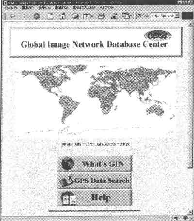
Figure 2:
5. Conclusion
at present GIN user are available to search by GPS data . But we think that GIN user aren't satisfied. So were are developing about more convenience system now. They are the problem which now confronts us.
- Plot search results on mp
- search function by clicking map
- narrow down search function
- package download function
<Sample RIF> ("^" means TAB code)
guest.rif
--------------------------------------------------------------------------------------------
LC0001^CEReS^LC0001U001^guest^gin@rsirc.cr.chiba-u.ac.jp^ftp://air.cr.chiba-u.ac.jp/gin/guest.rif^1997/07
/14^18:05:11^2^2.
GID001^Indonesia^nothing
GID002 ^Mongol ia^ Nothing
PID001^3^0^026^1996/09/15^13:49:35^0^-7.5498333^111.735^172^74^guest¥image¥Indonesia¥1s101.jpg^ftp://
air.cr.chiba-u.ac.jp/gin/guest/thumbnail/Indonesia/1s101.jpg^24^123^640^480^0^GID001^Nothing .
PID0002^3^026^1996/09/15^14:06:27^0^-7.57365 111^8621667^225^74^guest¥image¥indonesia¥is102.jpg^ftp://
air.cr. chiba-u.ac.jp/gin/guest/thubail/Indonesia/1s102.jpg^24^124^640^480^0^GID001^Nothing.
-----------------------------------------------------------------------------------------------
- Header section.
Local data center ID, Local Data center name, registered user ID, user, registered user's e-mail address, FTP address of RIF, last modified data, last modified time, number of group, number of registered images.
-group info section
group ID, group name, comment of group.
-image info section .
image ID, record condition, time recorded condition,. GPS camera ID, taken data, taken mode, latch time, latch mode , latitude, longitude, country code, original image path, thumbnail image path, color depth of image, size of image, pixel number of image, line umber of image, permission, group ID, comment of image.