| GISdevelopment.net ---> AARS ---> ACRS 1997 ---> Poster Session 1 |
Watershed Prioritization For
Soil Conservation Planning With Mos-1 Messr Data, Gis Applications And
Socio- Economic Information
A Case Study Of Tinau Watershed, Nepal
A Case Study Of Tinau Watershed, Nepal
Shyam Sundar Shrestha,
Kiyoshi Honda And Shunji Murai
Space Technology Application And Research Program
Asian Institute Of Technology
Abstract Space Technology Application And Research Program
Asian Institute Of Technology
Nepal is a mountainous country with many watershed and sub watershed covering the catchments of many rivers and lakes throughout the country. However, the rapidly increasing population and the consequent loss of forest and the intense agricultural land use in the slopes has resulted in degrading watershed in most of the districts. Since it is not possible to launch watershed management projects all over Nepal at the same time, it is very important to use some method to prioritize watershed on the basis of soil degradation status of various watershed. This study is an attempt in this direction by using remotely sensed data, together with socio economic data and other data on a GIS environment to assess the watershed conditions for a watershed in western Nepal.
Introduction and the Study Area
The study area is called Tinau watershed, and is located in the district of Plapa in western Nepal. The watershed has a total area of 333 square kms and consists of seven subwatersheds. The geographical coordinate of the study area from 27045'00" to 270 52'52" and 83025'30" to 43042'30" E. Most of the watershed falls in the lower Mahabharat range of mountains and the elevation from 330 meters to a maximum of 1893 meters. The average annual precipitation recorded at one of the stations in the watershed is 1494 mm.
Materials and Methods
The following data have been used for this study:
- Satellite data, MOS-1b, Path /row 056/081, acquired on January 26,1993 and Landsat TM path/row 142/41, quadrant 3,4, acquired on November 26,1990.
- Aerial Photographs acquired on November and December 1990, approximate scale 1:50,000.
- Topographical maps 1:25000 and 1:50000 from Department of Survey, land use, land system and land capability maps at 1:50,000 developed by Land Resources Mapping Project (LRMP) based on aerial photographs of 1978.
- Geological maps district administrative maps etc.
- Data from socio economic survey at the field and the population, climatic and other data available from various offices.
| SES = | LEA*10+MEA*20+
HEA*30 ------------------------------------------- Total Area |
Where,
SES= status of the subwatershed,
LEA= low erosion area
MEA medium erosion area, and
HEA= high erosion area
Low, medium and high erosion areas were defined for each parameter affecting soil erosion as shown in Table 1 and then final soil erosion overlaying such thematic maps for each parameter developed status map.
| Parameter | Categories | Relative erosion | Score for SES |
| Aspect | North, North-east, North-west | Low | 1 |
| East and West | Medium | 2 | |
| South, South-east and South-west | High | 3 | |
| Slope gradient | <15% | Low | 1 |
| 15-30% | Medium | 2 | |
| >30% | High | 3 | |
| Drainage density | No drainage in 500*500 m grid | Low | 1 |
| Drainage yes, but no 1st and 2nd order stream | Medium | 2 | |
| 1st and 2nd order steams in grid | High | 3 | |
| Soil types | Clayey | Low | 1 |
| Loamy | Medium | 2 | |
| Sandy | High | 3 | |
| Land use/cover | Forests>40% crown cover, tars, valley cultivation, rocky areas | Low | 1 |
| Forests 10-40% crown cover, level terraces cultivation, shrub lands | Medium | 2 | |
| Forests <10% crown cover, sloping terraces cultivation, gully and land slide area, system side 100 meters | High | 3 |
After making such thematic maps classifying the study area into LEA (low erision area),MEA (medium erosion area)and HEA (high erison area) for each parameter, a final map of soil erosion status was developed for showing the erosion status of defferent subwatershed within the study area. The flow chart of those steps in generating soil erosion status map is given in Figure1.
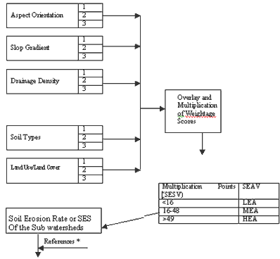
SES=[{(LEA*10)+(MEA*20)+(HEA*30)}/Total Area]
Figure 1: Flow chart showing the methods for evaluation soil erosion status (SES)
Results and Discussion
It has been found Bhainskatta Khola, Kusum and Hulungdi subwatersheds are most serious in terms of watershed condition as shown in Table 2, which summarize the results of classification of sub watershed into different of low, medium and high erosion areas.
Figure 2 represents the map of the whole watershed showing the categories of low medium and high erosion areas.
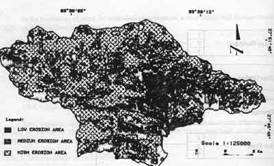
Figure 2: Soil erosion status map of Tinau watershed, Palpa, Nepal
| Name of sub watershed | Percentage areas under different erosion categories | ||
| Low | Medium | High | |
| Bhainskatta Khola | 3.67 | 26.40 | 69.93 |
| Kusum Khola | 3.79 | 27.37 | 68.87 |
| Hulungdi Khola | 3.29 | 26.37 | 68.34 |
| Majhare Khola | 10.55 | 27.62 | 61.83 |
| Lower Tinau Khola | 11.31 | 40.04 | 48.65 |
| Upper Tinau Khola | 15.16 | 41.90 | 42.93 |
| Sukhajor Khola | 41.51 | 32.49 | 26.01 |
| Whole wateshed | 13.50 | 31.60 | 54.90 |
As a result of the analysis of the soil erosion status, it can be recommended that the subwatershed priority for soil conservation programs should be Bhainskatta Khola, Kusum Khola, Hulungdi Khola, Mahare Khola Tainau Khola Tinau Khola and Sukkajor Khola respectively. Since it may not be possible to launch watershed management program for the whole watershed at once due to financial and institution limitations, such a categorization provides scientific basis for a stepwise project intervention in the area.
A socio economic survey conducted in study area also showed that the subwatersheds which have been found most serious interm s of bio-physical dergradation are also the areas where the farmers have felt most serious decline in productivity of agriculture crops (more details of this are given in Sherstha1996). This given added importance to the necessity of launching project in those areas so that project will be perceived by the people as their own project thus making people' participation in the project more likely helping to make the project successful.
Conclusion
The main conclusions of this research are following:
- It is possible to make watershed erosion status studies by using simple methods without going for very detailed quantitative methods like the Universal Soil Equation method in order to make prioritization of subwatersheds for project intervention.
- Remote Sensing and GIS, with the integration of socio-economic data is very useful for watershed planning and management.
Shrestr, S.S (1996), Watershed Planning for the sustainable Development of Natural Resources using Remote Sensing and GIS: A Case of Tinau Watershed, Papal, Nepal, Mater thesis submitted to Asian Institute of Technology, RSPR No.SR-96-21