| GISdevelopment.net ---> AARS ---> ACRS 1997 ---> Poster Session 1 |
Geometric correction by GPS
V.Vorrawat, F.Cheevasuvit,
K.Dejihan, S.Mitatha and A.Somboonkaew
Faculty of Engineering,
King Mongkut's Institute of Technology Lnadkrabang,
Bangkok 10520, Thailand
Abstract
Faculty of Engineering,
King Mongkut's Institute of Technology Lnadkrabang,
Bangkok 10520, Thailand
Geometric distortions are appeared in the satellite image during the scanning process. The traditional method for correcting the distortion employs some highlights features such as the crossing road. There features are known as ground control points which must be recognizable both in the image and in the reference map. The coordinates of ground control point both image and map are used to established a mathematical model. This mathematical model is used to correct the geomantic distortion of image. however, in some developing country, the construction is land are appeared rapidly. As the modification of map is done in some period of ten or twenty year. Therefore, the map is not update enough. T improve the revision of geometric correction, we propose the use of global positioning system (GPS) for acquiring the coordinate of ground control point instead of map. It will give the more correct of geometrical form of area around the new construction roads.
1. Introduction
Since raw data of remote sensing image, acquired by satellite is represented various types of geometric distortions. The traditional method for correcting these distortions is establishing mathematical relationship between the address of some highlight features pixels in an image and the corresponding coordinates of these points on the map [1], the problem will be existed, if the map is no update enough for some country due to the construction in land are enough rapidly such as roads . therefore some new roads will appeared in the images but not yet in the map since the modification of map is done in some period of the year of twenty years for some poor countries. To solve this problem, the global positioning system (GPS) is used to acquire the coordinates of ground control points (GCPs) instead of the maps . these data will be give the more correct of geometrical form especially the area around the new the area around the new constructed road.
2. Transform polynomials for image correction
For our proposed, the ground control point (GCPs) are acquired by GPS. These GCPs are located dispersally through the image scene for more reliable the correction. The main CGCP's coordinates are obtained form the intersection of two new roads where most of them are not exist in the map. The GCPs are considered as the coordinate in (X,Y) plane, while the corresponding coordinates of image pixel are located in (u,v) plane. The relationship between these two coordinate system can be defined by the mapping polynomial. The second order of transform polynomial is used for this papers. The polynomials are defined as the following equation.
v=b0+b1x+b2y+b3xy+b4x2+b5y2
The coefficient a0 to a5 and b0 to b5 can be determined by sing the criterion of least mean square error. After the coefficients are obtain, the coordinated of each image pixel will be transformed. After the coefficient are obtain, the coordinated of image pixel will be transformed. The transformed coordinates will not usually need to assign the brightness value to the center location of each pixel in the corrected image . Here, the linear interpolation is applied for image resampling.
3. Experimental and result
The raw image which needs to correct the geometric distortion is shown in fig. 1. the coordinates of GCP form CPS are circled in the image ( while the coordinates of GCP form MAP are assigned by triangles ). By using the mention transform polynomials and interpolation, the corrected image is shown in Fig. 2, while the corrected image in Fig. 4. is obtain by using the coordinates of map in Fig. 3.
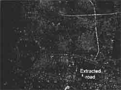
Figure 1 Raw image
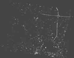
Figure 2 Geometric correction image by using GPS
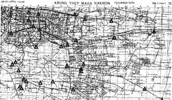
Figure 3 Map (D is GCP)
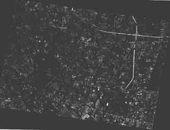
Figure 4 Geometric correction image by using Map.
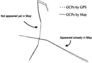
Figure 5 Difference of extracted roads
4. Conclusion
As we know, the acculate ground control points are essential to an acculte correcting [2]. So the coordinates of points acquired form GPS are surely more aculate than the coordinates which obtain from the map because of the roughness of map scale. By comparing with the map, more ground control points can be acquired form GPS, because of the new construction roads which are not appeared yet in the map. Therefore, the geometric correction by GPS will give more correctly when comparing the image in fig. 2. with the image in fig .4. Since, we used other personal compute for processing images, therefore the size of image is limited. Here the image of size 1593x1137 pixels is use for demonstration.
Acknowledgement
The author would like to thank the National research council of Thailand (NCRT) for providing the satellite images.
Reference
- J.A. Richaeds, " Remote Sensing Digital Image Analysis: An Introduction ,Springer - for providing, Berlin, New York, 1989.
- Erdas Field Guind, 2nd Edition, Version 7.5, July 1991.
- Berastein, " Image Geometry and Rectification. In. R.N.Colwell ( Ed.)," Manual of Remote Sensing, 21, Chapter 21, Falls Church. Va American Sosiety of photogrammetry.