| GISdevelopment.net ---> AARS ---> ACRS 1997 ---> Poster Session 1 |
Tropical Forest Cover Typees
Differntiation using Satellite Optical and Radar Data:A Case Study From
Jambi, Indonesia
Abdul Hamid Marwat Agus
Wary anta Yousilf Ali Hussin
The International Institute for Aerospace Survey
And Earth Science (ITC)
7500AA, Ensched, The Netherlands
Fax (31) 53-4874-399
E-mail :HUSSIN@ITC.NL
Abstract The International Institute for Aerospace Survey
And Earth Science (ITC)
7500AA, Ensched, The Netherlands
Fax (31) 53-4874-399
E-mail :HUSSIN@ITC.NL
The capabilities of optical (Landsat TM and SPOT) and radar (JERS-1 and ERS-1) satellite images for mapping tropical cover types differentiation were compared and the relationship between some forest stand parameters and radar backscatter determined. The methodology used individual image of each optical and radar satellite were classified using computer pattern recognition and visual interpretation. It was found that SAR satellite data can add new capability to the optical images in radar to obtain more reliable cover types mapping.
Introduction
Never before in the history of mankind, have trees and forests assumed that global importance that is evident today. Forest resources are important socially, economically and environmentally, especially tropical forests which are the home of least two-thirds of the world living organisms. Forest are being destroyed at alarming rates worldwide. The increasing rate of the deforestation of tropical rain forest grave cause for concern on several counts. Habitats communities and unique system are lost before they can be studied. According to estimates there are about 1900 million hectares of tropical forest in the world, but this number is expected to decrease to 500-800 million hectares by the year2050. Scientists dealing with trees and allied subjects have come to a wise conclusion that if that we fail to conserve the remaining tree wealth and also fail to rehabilitate the deforested and degraded wastelands in as short a time possible then the every survival of both human race and wildlife will be in danger.
Indonesia has large tropical forest (about143 million hectares or 75% of the total land surface). The Indonesia Government has set the year 2000 as target to reach sustainable forest management for timber production. An urgent need exists for data on actual forest extent, forest biophysical characteristics, the process of deforestation and land cover change. Data for the verification of sustainable forest management and surveillance of forest reserves are also needed. Since 1989,Indonesia Government is doing an inventory of forest, using a combination of aerial photography and ground check. However, cloud, fog and rain can prevent acquiring useful information. To overcome this problem, the Ministry of Forest has chose satellite radar data. Radar system such as ERS-1 (European Remote Sensing Satellite), JERS-1 (Japan's Earth Resources Satellite) and Radasat has several unique advantages over optical system. These including the capability to penetrate clouds and to be operated day and night. Similarly, forest damage cannot be detected at an early stage damage detection id possible. Current conventional methods and using optical satellite images to acquire data on yearly basis largely fail due to the problems (severe cloud cover, rain ,etc.) mentioned above. The objectives of this research were: to compare between the ability of radar satellite imaging system (ERS-1 and JERS-1) and optical satellite scanning imaging system (Landsat and Spot) data to detect tropical forest cover types, and to test if there is any relationship between tropical forest characteristics (e.g.DBH,height, basal area and crown coverage) and the radar backscatter of ERS and JERS images.
Description of study area
The study area is located approximately in 01025'00" to 01045'00" Latiture South and 102015'00" to 102045'00" Longitude East ,line in jambi provience, between kota jambi and gunnug Kerinci, in Central Sumatra, Indonisia. The study area covers about 50 km * 35 km(1750km2), and comprises a mountainous nature reserve area in the west and timber concession areas in the east. Apart from th etimber concession the area also contains along Tebo, Batang Hari, and Batang Tabir rivers, " transmigration" villages, and oil palm plantation/oil palm estate.
The forest concession (HPH) has been selectively logged by PT Sylya Gama, which covers about 30.000 ha. part of concession will be clear felled to establish an Industrial Forest Plantation (HTI). Part of the forest allocated for research on forest regeneration and management, and education purposes for Faculty of Forestry, Gadjah Mada University, Yogyakarta. Forest, Rubber, oil palm, rice, Clear cut, and Water, are the main land cover types.
Materials and Methods
For the study comparison between optical and radar satellite images, remote sensing data acquired by both passive and active system were used. The optical images were from Landsat Thematic Mapper ™ and SPOT, while radar data was from ERS-1 and JERS-1SAR images. Landsat TM image acquired on 15-9-1993 has seven bands but only three bands were used for the study viz. band 3(0.63-0,69 micro meter, red), band 4(0.76-0.90 micro meter, near infrared), and band 5(1.55-1.75 micrometer, middle infrared). The spatial resolution of this image is 30m*30m.SPOT image was acquired on 05-9-1994 has three bands viz band1 (0.50-0.59 micrometer, green) band2 (0.61-0.68 micrometer, red) and band 3 (0.79-0.89 micrometer, near infrared). The JERS-1 SAR image was acquired on 16-9-1994 having L-band (23.5 cm wavelength) and incidence angle of 35 degrees. The spatial resolution is 18 meter. The ERS-1 SAR images has 30 meter resolution acquired on 08 June 1995 in C-band (5.6 cm wavelength). Other anicillary data which were used ain this research include topographic maps 1:50,000 ofo 1982 and 1:250,000 of 1982. Research methodology is illustrated in figure 1.
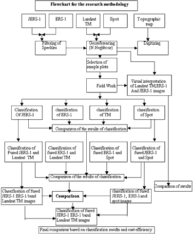
Figure 1: Methodology flow chart for the research
Result and Discussions
Results of Supervised Classification of Landsat TM image
The supervised classification of Landsat TM data resulted into nine classes: water, swamp, agriculture, logged-over forest, secondary forest rubber, oil palm, grass/along and cleas cut areas. It was not possible to have more than nine classes because of the overlap between the clusters in the feature space. It was especially difficult to separate settlements from the forest/agriculture or old secondary forest from the young secondary forest. This was due to the fact that settlements in the study area are always surrounded by the home-sated gardens which include different types of trees that exist in the forest area too. This results in mixed spected reflectance characteristics. Thus it was decided to combine some of these classes.
Settlements were not classified on TM image due to the fact that the people in the study area grow trees/fruit tree, agriculture crops in and around their houses as homestead gardens which it spectrally confusing with other classes. It was also difficult to classify rice separately as there was overlap between rice and other agriculture fields or bare land farmers in the study area normally plant rice starting in May and harvesting in September. Since the Landsat TM image was acquired in September( 15 September), rice could take on the features of other agriculture fields or bare soil
Results of Supervised Classification of SPOT image
Supervised classification of SPOT image resulted in six classes: water, agriculture, logged-over forest, secondary forest, and rubber and clear-cut areas. The presence of clouds and haze in the image affecting the spectral reflectance value of the cover types. Classifying further classes resulted in overlap between the clusters and misclassification of the true classes
Results of Supervised Classification of JERS-SAR image
The supervised classification of JERS-1 SAR image comes up with seven land cover classes. These classes are: water, agriculture, logged-over forest, secondary forest, rubber, clear cut areas and settlements, Since JERS-1image has single band (L-band 23.5 cm) HH polarization, with incidence angle 35 degrees, therefore it was not
Possible to have more than seven classes because overlap was occurring between the clusters in the feature space for further classification. Oil palm was not classified as this was always misclassified as rubber or agriculture fields were also were classified as clear cut areas because these fields were either barren or having very young crops which acted as specular reflector. Similarly some misclassification also occurred among water, agriculture and clear-cut areas. Forest classification was better comparing to ERS-1.
However settlement were significantly clearer on JERS-1 image as compared to optical images because of the radar corner reflection phenomena. The appearance of settlements on radar image is due to geometric configuration of urban features. The most favorable geometric configuration for an object to become a corner reflector are often man made structures. The side of a building combined with reflection from a ground is an example of such a structure. When two such surfaces are at right angles and open to the radar, a dihedral corner reflector is formed. A wave scattered from a dihedral corner reflector will undergo a reflection at each surface and will return in the direction from which it came. Therefore settlements in the radar image have high backscatter values.
Results of the supervised classification of ERS -1 SAR image
Like JERS-1 image ERS-1 image have also single band (C-band 5.6cm) VV polarization with 22 degrees incidence angle but supervised classification of ERS-1 image resulted in to five classes only as shown in these are: water, forest, agriculture, clear-cut areas settlements. In ERS-1 rubber and secondary forest were having overlap with logged-cover forest and therefore these three classes were merged in to a single class. One possible reason for is the short wave length (C-band=5.6cm) of ERS-1 which does not interest with forest cover types. Oil palm as in JERS-1 was again not classified in this image. Similarly some misclassification and overlap was also noticed among water, agriculture and clear cut areas. However settlements were classified clearly with high accuracy because they acted as corner reflector as mentioned earlier for JERS-1.
Visual interpretation in general, ERS-1 image was able to recognize three more classes that was not able to recognize during digital classification. These are: secondary forest, oil palm and rice. JERS-1 image was also able to recognize four more classes i.e. rice and oil palm and one subclass of agriculture and secondary forest each. The ability to recognize forest, rubber and oil palm plantation using JERS -1 were better than ERS-1. This was due to L-band(23.cm wavelength) of JERS-1 which penetrate through the vegetation canopies better than the C-band(5.6cm) of ERS-1. Similarly interpretation of TM image was able to recognize seven (7) more classes than the digital classification. These are: settlements, rice and roads one more subclass of logged-over forest, secondary forest, rubber, oil palm and agriculture each. However, the appearances of settlements on radar image (especially in ERS-1 image) were significantly clearer than the TM image because of the radar image reflection phenomena. As said earlier that appearance of geometric configuration for an object to become a corner reflector are often man made structure. The side of building combined with reflection from a ground is an example of each a structure. When two such surfaces are at right angles and open to the radar, a dihedral corner reflector is formed. A wave scattered from a dihedral corner reflector will undergo a reflection at each surface and will return in the direction from which it came. Therefore settlements in the image appear very bright. The river, rice fields and clear-cut areas appeared darker on the radar image. This is due to specular reflection from these classes. This means that radar energy reflects away form the antenna (e.g. mirror like reflection). Thus little radar energy returned to the antenna
Accuracy analysis of classified amps
Accuracy assessment is a general term for comparing the known reference data (ground truth) and the corresponding results of classification to assess the classification accuracy. One of the most common means of expressing classification accuracy is the preparation of a confusion matrix or a contingency table. In order to assess the accuracy of different classified maps, a confusion matrix was developed for each one of them. A confusion matrix shows a cross tabulation of pixel of test field sample and the classification results. Using the Crossing option of ILWIS program. Every row in the matrix corresponds to a class in the test field sample; every column corresponds to a class in the classification result. Thus the boxes in the diagonal of the contain the number of pixel per class that were correctly classified. The off-diagonal boxes contain the classification error pixels. The overall accuracy is the sum of all correctly classified pixel in a sample divided by total pixel of a sample.
From the confusion matrices the overall accuracy percentage of classified single images mentioned above the following accuracy percentage found in single images of Landsat TM, SOPT, JERS-1 and ERS-1 were 92.12%, 78.26%, 87.67% and 91.5% respectively. However in the fused images of TM with JERS-1, ERS-1 and TM with both JERS-1+ERS-1 were 93.0%, 93.09%, and 92.72% while for SPOT with JERS-1, ERS-1 and SPOT with JERS-1+ERS-1 were 85.01%, 83.84%, and 89.69respectively. For the final fused image of both optical radar images it was found to be 93.68%.
From the four confusion matrices one for each single image, it is clear that the Landsat TM has highest (92.12%)overall accuracy followed by ERS-1 JERS-1 and SPOT respectively. The lowest overall accuracy was found in the SPOT image. This was due to clods presence in the SPOT image. However it should be noticed that the information (number of classes and type of classes) obtained in all the images are not the same. For instance ERS-1 has less number of classes and less details e.g. ERS-1 has one class of forest (where all forest classes have been merged) while JERS-1 has three classes of forest (Logged-over Forest, Secondary Forest and Rubber). The confusion matrices for the fused images of optical and radar images indicate that the overall accuracy for each map and accuracy for each individual class has improved with fusion. Water has highest accuracy followed by settlements, clear-cut areas, rubber, logged-over forest, agriculture, oil palm and secondary forest respectively.
Accuracy analysis for clear-cut areas
Table (1) shows the result of classification accuracy for clear-cut areas in each map. As a single image Landsat TM has highest accuracy (92.14%) for clear-cut, while SPOT has lowest accuracy (83.08%) which can be attributed to cloud presence. Both radar images have reasonable high accuracy for topography and roughness of terrain. However, in fused maps from optical and radar images the accuracy for clear-cut areas has been improved like other classes.
| No | MAP | Accuracy % for clear-cut |
| 1 | Landsat TM | 92.14 |
| 2 | SPOT | 83.08 |
| 3 | JERS-1 | 89.1 |
| 4 | ERS-1 | 87.89 |
| 5 | Landsat TM & JERS-1 | 93.44 |
| 6 | Landsat TM & JERS-1 | 93.03 |
| 7 | Landsat TM, JERS-1 & ERS-1 | 93.89 |
| 8 | SPOT&JERS-1 | 85.24 |
| 9 | SOPT&ERS-1 | 85.71 |
| 10 | SPOT, JERS-1, ERS-1 | 90.9 |
| 11 | TM, SPOT, JERS-1, ERS-1 | 93.93 |
The relationship between radar backscatter and forest stand parameters
The relation between radar backscatter and forest parameters, such as height, diameter at breast height (DBH), basal area (BA) and stand density has been partially a challenging issue in this study,. If these relationship shows high positive or negative correlation, researchers and foresters, might then be able to determine those forest stand characteristics from the radar data. To determine the relationship between radar backscatter and the forest stand parameters (i.e., DBH, BA, crown cover and height). 45 sample plots were collected. The influence of the wavelength on the radar backscatter is related to the penetration capability of the radar energy into forest canopy. Longer wavelength (L-band 23.5cm) has higher ability to penetrate forest canopy than C-band. The results of the signatures from JERS-1 image showed good positive correlation r = 0/75 with basal area and r =0.7 with basal area. Both height and crown cover had no statistically significant correlation r =0.21 and r =0.25 with JERS-1 radar backscatter. It is believed that longer wavelength like L-band (JERS-1) should have a very good relationship with forest stand parameters. However, most of the research work that has been done this issue done with plantatyions not natural tropical forest. ERS-1 (C-band5.6cm wavelength) radar backscatter showed low correlation with all stand parameters (e.g.r =0.38,0.17,0.47) except with crown cover r =0.64.