| GISdevelopment.net ---> AARS ---> ACRS 1997 ---> Coastal Zone/Oceanography/Meteorology |
Assessment of Natural
Resources for Conservation of Harike Wetland (Punjab), India through
Remote Sensing Technology
Rajiv Chopra, V. K. Verma and P. K. Sharma
Punjab Remote Sensing Center, Ludhiana 141 004 India
Rajiv Chopra, V. K. Verma and P. K. Sharma
Punjab Remote Sensing Center, Ludhiana 141 004 India
Abstract
The Ramsar Convection of IUCN held in 1971 in Iran raised global attention on conservation and management of wetlands. Harike wetland in the Indian State of Punjab has been declared wetland of international importance. Thus it is felt necessary to reclaim and develop this wetland for its optimum potential use, but a reliable and accurate data base is not available. The present endeavor aims at generation of aims at generation of data base in terms of landuse/landcover, extent of waterspread and its seasonal variation, aquatic, vegetation status and turbidity levels of lake water, using multidate satellite data. The threats to Harike wetland have been identified and adequate measures for its conservation and management suggested.
Introduction
India by virtue of its extensive geographical extent, varied terrain and climatic conditions, supports a rich diversity of inland and coastal wetland ecosystems. The wetland ecosystems have not received deserved attention from the planners, although such systems have potential for high biological activity until the Ramsar Convection of IUCN held in 1971. Remote Sensing techniques together with ground truth are widely used to collect information on qualitative and quantitative status of natural resources in protracted areas (Parihar et la., 1986). The wetland ecosystems of ecosystems of Kaziranga, (Dutt et al., 1988) and Sunderbans, India (Naidun et al., 1988) have been studied using IRS 1A data. Wetland resources mapping in West Bengal, India using remotely sensed data have been done by Sharafat Ali et al., (1991).
The Harike wetland has assumed international importance as it is a breeding ground and habitat for a large variety of migratory as well as domiciled birds. In the recent years anthropogenic pressure has created an ecological imbalance to a great extent. It is therefore felt necessary to reclaim and develop this wetland ecosystem for its optimum potential use, but a reliable and accurate wetland data base is not available. In this study an attempt has been made to generate base line information about spatial distribution and the variation in the water spread, turbidity and vegetation in different seasons for Harike Wetland using multidate satellite data.
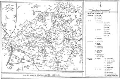
Fig.1 Land use/ Land cover Map of Harike Wetland and Environs
Study Area
The Harike wetland ecosystem rich in acquire flora and fauna has an area of 285.1 s. km and spreads in four districts of Amritsar, Ferozpur, Kapurthala and Jalandhar in Punjab, India. The area under study forms a part of Indo-Gangetic alluvial plain of Holocene age, (Chopra & Sharma, 1991) and is located between latitude 310 13' N and longitude 750 12' E. The area is drained by Satluj and Beas rivers and their tributaries. Both these perennial rivers rise in the high Himalayas and traverse long distance before entering the state of Punjab and Coalesce at Harike, where an irrigation barrage was built in fifties. This man made lake not only recharges ground water but also provides irrigation to parts of Punjab and neighboring state of Rajasthan through Sirhind feeder and Rajasthan Canal. The area under study experience an annual rainfall of 668 programme. The south western monsoon consisting about 70% of the annual rainfall begins in first week of July and extends upto September. The study area experience extreme heat during the months of April, May and June. The mean daily maximum temperatures rises upto 430 C in the month of June and mean daily minimum temperature as low as 0.60 C in the month of January.
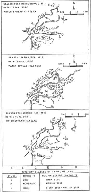
Fig.2 Monitoring of Water Spread Turbidity of Harike Wetland
Methodology
The land use/land cover map of Harike wetland ecosystem was prepared through visual interpretation of IRS-1A LISS-IONOSPHERE multidate data (post monsoon October 1992 and pre monsoon-March 1993) in the form of false colour composites (FCC) generated from bands 2, 3 and 4 on 1:50,00 scale and diapositives on 1:1 M scale. Standard image interpretation characteristics such as tone, texture, shape size, pattern and association were used to delineate different land use categories. Procom 2 was used to enlarge the film diapositives for proper identification and delineation of various land use categories and to transfer the details on the base map prepared from survey of India (SOI) topographical maps on 1:50,000 scale. Pre monsoon and post monsoon variations in water spread and turbidity of the water in the lake have also been recorded. The quantitative turbidity ratings viz., low, moderate and high were assigned based on the hue manifested on the false colour composites.
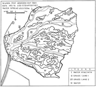
Fig.3 Aquatic Vegetation Status of Harike Wetland
Results and Discussion
- Land use/land cover of Harike wetland ecosystem
The land use/ land cover map of study area (fig. 1) has been prepared following the classification system proposed by Space Applications Group, Space Applications Center (SAC), Ahmedabad, India. The study area has been classified into five major units viz., built up land, agricultural land (crop land, plantation etc.), forest, wetland and wetland. These are further subdivided into sub classes and their areas have been computed. The perusal of the data indicates that out of total wetland area of 285.10 sq. km area is waterlogged. The lake/ponds cover 3.60 sq. km whereas 0.50 sq. km is covered by oxbow lake/cut off meanders. The area under wasteland (land with or without scrub) comes out to be 3.60 sq. km of area respectively. Substantial area (198.6 sq. km) of the wetland is being used for agriculture.
- Water Spread and Aquatic Vegetation
In this study the seasonal variation in water spread of Harike lake has been recorded using multi seasonal (Post monsoon October 1992, Spring season February 1992 and Pre monsoon May 1992) data. It has been revealed that post monsoon extent of Harike wetland was 82.8 s. km where as the pre monsoon spread was 76.8 s. km. The water spread in the post monsoon is more because of release of more water from the Pong and Bhakra dams and rain water from the area below the dams through feeding rivers i.e. Beas and Sutlej (fig. 2).
Visually three types of aquatic vegetation could be recognized (fig. 3). A large portion of wetland is covered by grasses.The grasslands have been classified into two categories based on variation in spectral signatures on the FCC i.e. vegetation type II and III. There is a possibility of miscalculation of water hyacinth with grassland because of spectral overlap between these classes. Verification of different types of vegetation was not possible due to inaccessibility of the area and non availability of other collateral data. Since these classes were separable so they are mapped as distinct units. The dominant species of grasses growing in the area are Saccharum munja (Munj)., Saccharum spontaneum (Kahi), Typha elephantia (Bater), Cynudon dactylion (Khabbal), Desmostachiya bipinnata (Dabb), Vitiveria Sp (Khas) etc.
- Turbidity
In this study the qualitative turbidity of Harike lake has been recorded based on hue as manifested on the FCC. The turbidity classification is based on the system proposed by SAC Ahmedabad. The turbidity of water in Harike lake is variable. The variation and distribution of turbidity of water during spring, pre monsoon & post monsoon seasons has been shown in Fig. 2.,
- Weed infestation: Water hyacinth (Eichhornia crassipes) is the main weed which has invaded Harike wetland. The area under the plant doubles every 6.2-15.0 days depending on the nutrient status of water.
- Siltation: In Harike lake silt had started depositing near the barrage in the beginning of 1985. Siltation has reduced the erstwhile lake to a shallow wetland now. Major amount of silt is deposited in the monsoon season when heavy rains wash down the soil from hill slopes and fields in the catchment area of the two rivers.
- Pollution: The pollution is the result of the nutrient input from sewage and effluents and wash down from agricultural fields of fertilizers sand pesticides into the two rivers (Sandhu et al., 1989).
- Water fluctuation: The depth of wetland is only a few meters when full. The depth reduces further in the lean periods when the inflow of water is less during summer. In fact, the irrigation is most desired at this stage, so more water has to be released into the canals from the wetland leaving with little water rendering portions of the wetland bare at the bottom. Illegal fishing and poaching are the other threats to the Harike wetland. These threats have resulted not only in shrinking of lake area but also deteriorated the natural environment for the survival of birds. These unfavorable conditions have forced the migratory birds to drift away from Harike lake which was once considered to be a safe dwelling place of them.
The Govt. of Punjab, declared Harike wetland as bird sanctuary in 1982. A number of conservation measures have been suggested to conserve Harike wetland after the declaration of Harike as Ramsar site in 1990. These measures include eradication of water hyacinth and use of recommended weevils, opening of sluice gates during monsoon, monitoring of water quality migration period, fencing some of the selected portions from encroachment and afforestation of the catchment area.
Acknowledgements
- Chopra, Rajiv and Sharma, P.K., 1993, Landform analysis and ground water potential in the Bist Doab area, Punjab, India, International Journal of Remote Sensing, 14 (17), 3221-3229.
- Parihar, J.S.; Kotwal, P.C.; Panigrahi,S. and Chaturvedi, N. (1986b). Study of wildlife habitat using high resolution space photographs. A case study of Kanha National Park. Special Publication, ISRO-SP-17-86, pp.65-82.
- Dutt, C.B.S., Ranganath, B.K. and Manikyam, (1988). Identification and mapping of coral reefs in middle Andaman. Proc. Symp. Ocean Resources. National Institute of Oceanography, Goa.
- Naidun, K.S.M. and Unni, N.V.M. (1988). The loss and accretion of Sunderbans. Proc. Symp. Wildlfe Habitat assessment, Oct. 22-23, 1986, Dehradun.
- Sharafat Ali, Saha N.C. and Suraj Bhan (1991). Wetland resources mapping in West Bengal using remotely sensed data. Nat. Symp. Remote Sensing of Environment. Dec. 10-12, 1991, Madras. pp.39.