| GISdevelopment.net ---> AARS ---> ACRS 1997 ---> Coastal Zone/Oceanography/Meteorology |
An Affection Study of Sewage
Treatment Factory to Aqua- Environments
Takashi Kano* , Kiyoshi Torii ** and Hiroshi Yamakawa ***
*Department of Maine Science & Technology, Faculty of Fisheries,
Tokyo University of Fisheries
4-5-7 , Minato-ku, Tokyo 108, Japan
tel : (81) -3-5463-0473 Fax : (81) -3-5463-0359
**Division of Environment Science & Technology, Graduate School of agriculture, Kyoto University
Kitashirakawa- Oiwake-cho, Sakyo-Ku, Kyoto 606-10, Japan
Tel & Fax : (81) -75-753-6459
***Department of Aquatic Bio -Science, Faculty of Fisheries,
Tokyo University of Fisheries
4-5-7, Minato-Ku, Tokyo 108, Japan
Tel : (81) -3-5463-0538 Fax : (81) -3-5463-0542
E-mail: Yabalone@tokyo-u-fish.ac.jp
Abstract
Tidal flat of kiya river Estuary, situation at east part of shimonoseki city, Yanagychi prefecture, had high productivity in short necked clam and green laver. Recently, they constructed a sewage treatment factory at reclaimed tidal flat neighborhood of the estuary. Though careful assessments were executed in the stage of designing, the productivity of short-necked clam and laver were lowered , because of the direct discharge of treated water to the front tidel flat. Authors would like to know the affect of discharged processed sewage water at a glance, and they tried to utilize satellite image data which possible to indicate aqua environments.
Introduction
Quality of water discharged from sewage treatment factory of second order treatment is fresh water on the other hand high nitrogen concentration and high temperature. Shimonoseki city constructed sewage treatment factory at Nogi Beach region to be investigated and water quality monitoring stations of green laver plantation are illustrated in fig. 2 dots in fig. 2 indicate water quality monitoring stations of green layer plantation are illustrated in Fig. Dots in Fig.
indicate water quality monitoring stations which carried out by the cooperative association of fisherman who engage in green layer plantation in order to prevent this from disease and disaster. And small circle in the same Fig. Are the additional monitoring stations as a link of environmental assessment.
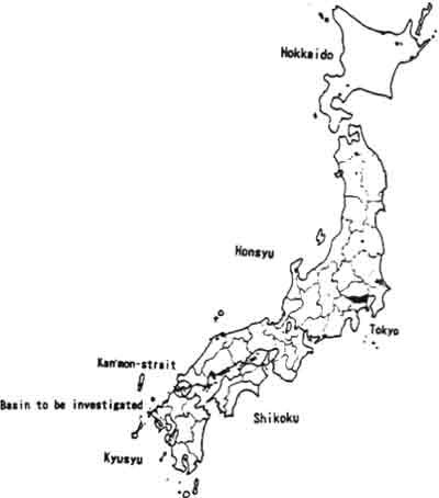
Fig. Japan and location of region on investigation
New sewage treatment factory which constructed in Nogi beach is called as San'yo sewage treatment factory. And the factory collects the sewage of 70000 inhabitants of Shimonoseki city, mainly at the side of Inland Sea of Japan. Degree of the treatment of the factory is second order and it discharges 0.18m3/s all the year round. The discharge from the sewage treatment factory is equivalent to about 10% of whole river discharge in Shimonoseki city which flowing into the Inland Sea of Japan. It means that sudden appearance of big river at Nogi beach. Then careful environmental assessments were carried out.
Green laver plantation
Green layer plantation is executed at estuary. Large tide range and supply of nutrient salt by the river discharge are necessary. They hold the plantation net vertically between tidal range with bamboo pile in the sea. Spore of green laver is put on the net and remained for about half a year, and net was dried and wetted reciprocally by tidal action, and expose to nutrient salts and sea water also reciprocally during it being in the ea.
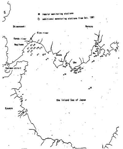
Fig. 2 Local illustration of investigation region
In the stage of the assessment, they considered that as processed sewage is nitrogen rich fresh water, it must be harmless to green laver plantation. And some cultivation tests were carried out. By the results of these tests, it was cleared that processed water does not act to blight green laver. But speed and amount of growth, and quality of difference between laver in natural blackish water and processed water were not recognized. The San'yo sewage treatment factory started to operate on the last half of '80s. and harvest of green laver plantation gradually decreased. Authors do not know the reason whey, but the affection of the discharge cannot be denied at all.
Short-necked clam
Short-necked clam lives in the sand of tidal flat. The tidal flat in front of Nogi beach where San'yo sewage treatment factory constructed was a good fishing ground of short-necked clam. The fisherman cooperative association of the region got good income with short neck clam as well as green laver plantation. But harvest of short-necked clam decreased drastically in recent years. It is considered easily that 0.148m3/s fresh water discharge affects the environments of short-necked clam existence. Ground water it is ebb could be entirely fresh water, and it continues 6 hours. The situation changed entirely.
In the stage of environmental assessment carried out, the fear to the change of environments and resulted decrease of natural resources harvesting are pointed out, ad one plan to transport processed water to enough upstream of Kiya river and discharge there in order to come to natural river water as possible. But any proposal was denied and direct discharge to the front tidal flat of the Nogi beach was executed.
Satellite image data
In order to recognize the change of the environments at Kiya river estuary, since post assessment after the completion of San'yo sewage treatment factory, through authors had heard that products of green laver plantation and shot-necked clam became decreased, it had remained as a statistical data. Then, the existence of satellite image data was reported recently, and planned to clarify aqua-environments of the region. Authors get JERS 1 visible band image data, which taken on 3 Feb. 1993, 15 Nov. 1995, and 1 Apr. 1997. Each data are illustrated in Figs. 3 to 5. Every image is after the sewage treatment factory started to work, therefore it is not cleared the aqua-environmental difference between before and after the work of the factory started. Authors should try to make efforts to get image data both before and after the work of the factory started. And not only with visible band but also thermal infrared in order to clarify the thermal condition of the aqua environments when it is flood especially to green laver plantation and water content of tidal flat when it is ebb especially to short-necked clam, for example the image data by Landsat TM. After checked the JERS 1 image data, authors began to look for the Landsat TM which taken on 1985 just before the work of the factory starts and 1997 very recent and several years after the work of the factory started. And it is hopeful to them that flood and ebb data for above both years.
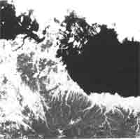
Fig. 3. Satellite image data by JERS 1 on 3 Feb. 1993.
As to the image data by JERS 1. Fig. 3 of 3 Feb. 1993 is cloudy and Nogi beach and Kiya river estuary cannot seen clearly. Flow pattern of Kan'mon strait and the estuary also cannot be recognized. Fig. 4 of 15 Nov. 1995, the big circulation or eddy can seen in the off-shore of the estuary, mouse of Kan'mon strait. To compare with Fig. 5, color of the estuary are quite different. Through left side of Kan'mon strait in Sea Japan, color of the estuary and Sea of Japan are entirely opposite. It might be flow direction of Kan'mon strait being contrary between in Fig. 4 and Fig. 5. But direction of the flow cannot be distinguished yet. If the time of image data be taken become clear and tide levels of both region are known by tide table, water mass and colors on the image data would be contrasted, afterward aqua-environments could be cleared.
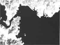
Fig. 4. Satellite image data by JERS 1 on 15 Nov. 1995.
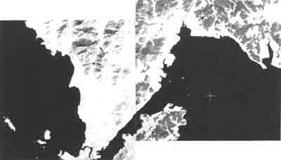
Fig. 5 Satellite image data by JERS on 1 Apr. 1997.
Anyhow, image data of visible band has a certain limit, suitable band region and taking apparatus should be selected by their purposes.
Conclusions
The objectives to be investigated be existed firstly, in this time. The Macro aqua environments of the region might be recognized, but the situation connecting to the objective matters of this case was not enough. Other band and apparatus should be tested to get results for the case like this.