| GISdevelopment.net ---> AARS ---> ACRS 1997 ---> Mapping from Space |
Digital Orthophoto
Rectification - 1:10,000 Sheet for Kandy City
Thilak Senanayake, M. P. M.
Sameeu and S. Munaweera
Environment and Forest Conservation Divisions,
Mahaweli Authority of Sri Lanka, Dam Site, Polgolla, Sri Lanka
Tel: (94)-08-499275 Fax : (94)-08-234950,
Email: kobchai@telelan.telecom.eng.kmitl.ac.th
Environment and Forest Conservation Divisions,
Mahaweli Authority of Sri Lanka, Dam Site, Polgolla, Sri Lanka
Tel: (94)-08-499275 Fax : (94)-08-234950,
Email: kobchai@telelan.telecom.eng.kmitl.ac.th
Abstract
Orthophotos can play a vital role in resource surveys as they show the terrain in fine detail. Good orthophotos provide invaluable high resolution information for resource planners. Recent developments in digital photogrammetric technique can be used to develop precisely orthorectified air photos quickly, cheaply and easily. This papers describes how available air photos can be integrated with Digital Elevation Models (DEM) to produce orthophotos using Arc Info and PCI-Easipace software tools. Similar methods could become standard operations in any Remote Sensing laboratory.
Available contour maps were used to develop a DEM for the study area using the Triangulated Irregular Network module. Vertical air photos at a nominal scale of 1:15,000 were scanned using a flatbed scanner at a resolution of 600 dpi. For these air photos Ground Control Points (GCP) were collected using a 12 channel GPS receiver in differential more. Fiducial marks and focal length of the camera were used to determine the interior orientation of each photo. Camera models were generated to calculate exterior orientation of these photos using GCPs. Orthophotos were then produced using the DEM and camera model. There air photos were mosaicked together to get the full coverage for the study area. Finally GPS was used to check the planitmetric accuracy of the product which compares favorably with the Sri Lank Survey Department published 1:10,000 scale map sheets.
Introduction
Recent developments in satellite imagery acquisition systems have opened up new responsibilities of using-high resolution images for land resources applications. By 1998 several commercial high resolution satellites will be in orbit and these will revolutionalise land surveys. However, many countries still use air photographs as major data sources for mapping and resource surveys. Usually these photos are converted into conventional planitmetric maps which depict only limited numbers of data layers extracted from the air photos.
Orthographic photographs (commonly known as orthophotos) are spatially corrected air photographs. Since these contain terrain features in fine detail, they provide invaluable base information for earth resources planners. Therefore, orthophotos can play a more important role tan conventional maps in land surveys. The first orthophotos were produced in the 1960s and at that time it was a time consuming and expensive procedure. However due to recent advances in computer technology, digital cartography and Remote Sensing techniques, orthophotos can now be produced speedily, and easily.
This study uses available vertical air photos to produce orthophotos coverage for Kandy City. A full 1:10,000 sheet (5 km x 8 km) was developed for this area at the Environment and Forest Conversation Division (EFCD) of the Mahaweli Authority of Sri Lanka using Arc Info and Easipace software tools.
Objectives
The objectives of this study were;
- To develop orthophotos coverage for the study are using available
vertical air photographs and contour maps to provide required land
information for resource planners.
- To investigate the possibility of producing larger scale
planitmetric base maps to use with Geographic Information Systems where
they can be effectively used for decision making.
The study area is situated within the Kandy District in the central hill county of Sri Lanka. Its spatial extents are covered by No. 54/19 tile of Sri Lanka Survey Department (SD) 1:10,000 map series with a total area of 40 s q km. The majority of the terrain is hilly with attitude ranging from approximately 430m to 900m. The major land cover types within this area are approximately 50% home garden, 10% urban, 9% paddy, 7% dense woodland and 7% grassland. Most of the areas excluding dense woodlands are accessible by roads.
Methodology
Development of a Digital Elevation Model (DEM)
10-meter interval contour maps produced using stereo plotters by SD were used as source maps for the DEM. The Triangulated Irregular Network (TIN) module of Arc Info GIS software was used for the development of the DEM. Intelligently selected points from contour maps were digitized to produce optimum triangulation avoiding unnecessary flat triangles. After generating the TIN model, a 10m resolution DEM was generated for the study area.
Selection and scanning air photos
Most recent vertical air-photo coverage for the study area was taken in 1987 at a normal scale of 1:15,000. From this coverage good quality alternate air photos (diapositives without scratches and dirt) were selected along fight lines to maintain 20% endlap or the study area. A low cost Hewlett Packard Scan Jet 4c flatbed scanner was used to scan these air photos. The scanning surface should be clear and dirt free to produce good quality images. Also the scanner should be calibrated for one photo to produce a good quality images and these settings then used to scan all other all photos. All photos were scanned at 600 dpi resolution. It is important that all four corner fiducial marks appear clearly in each scanned image.
Ground Control Points (GCP)
For each air photo 20 equally distributed accessible points were identified and marked as GCPs. With a base station set up at a known location, a Trimble Pro XL GPS rover was used to collect these GCPs in 3D mode. Later, these rover files were differentially corrected to obtain accurate Northings (Y), Eastings (X) and elevation (Z) co-ordinates in Sri Lanka National Grid values.
Orthophoto Generation
PCI-Easi Pace software was used for the orthorectificatin process. For each photo previously collected GCPs were entered with their X, Y and Z values interactively using GCP Works module of the software. These points were saved in Ground Control segment of each image file.
For each photo the Principal Point and the photo size was interactively determined to create the fiducial text segment. The focal length of the camera lens and the distance between corner fiducial marks are required for this purpose. Later, Ground Control segment together with the fiducial segment were used to generate the camera model for each photo (flight camera parameter estimation). Orthorectification was then performed for all photos using the camera model and DEM. The cubic convolution method was used for resampling. Finally all rectified photos were mosaicked together to produce full coverage for the study area. Color matching program were used to minimize total differences between photos during the mosaicking process.
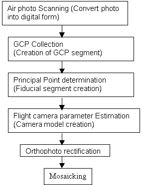
Figure 1. Flow chart of air photo Orthorectification Process.
Planimetric Accuracy
To ascertain the planimetric accuracy of the orthophot mosaic 20 equally distributed check points were used. These points were selected in a way that they could be clearly identified from the orthophoto and from the 1:10,000 Survey Department detail maps. Later X and Y co-ordinates of these points were obtained from a Trimble GPS rover in differential mode. Co-ordinate values were obtained from the orthophoto for these checking points. Root Mean Square (RMS) error for X and Y co-ordinates were determined between the GPS reading and the orthophoto.
The orthophoto was then displayed at 1:10,000 scale and the RMS error of the X and Y coordinates were determined against the SD 1:10,000 map. The following formula was used for RMS error calculations.
RMS Error = Ö(ånl(Pi-ti)2)/n
Where pi = Orthophoto measurement
ti = GPS measurements
n = Number of measurements
Finally, the orthophoto was visually checked with GPS collected roads and then plotted at 1:10,000 scale with the SD detail map for visual comparison.
Results and Discussion
Calculated RMS errors to determine planimetric accuracy are given in table 1.
| Source | X co-ordinate RMS error (m) |
Y co-ordinate RMS error (m) |
| GPS | 1.2 | 1.6 |
| 1:10,000 Detail Map | 8.4 | 11.2 |
When checked visually the orthophoto compares very well with GPS collected roads through out the study area. It also matched well with details of SD maps when plotted at 1:10,000 scale. Compared to the nominal 1:15,000 scale of the original air photograph the final orthophoto can be successfully utilized in even greater detailed land surveys. As it is a geo-referenced product it can also be used as a large scale base map to extract data layers to input into a GIS.
The quality of the final orthomap will mainly depend on several major factors such as the accuracy of the DEM, the clarity of the air photos, the scanning resolution and quality, the GCP accuracy, the camera model and he Mosaicking. Therefore, it is important to be precise with all of these factors. In this study camera calibration parameters were not considered due to unavailability of information. If these parameters are known the camera modeling will be more precise and final product will be more accurate. Scanner distortions should be taken into account for more accurate mapping purposes. However, if digital air photos are available scanners are not required. When Mosaicking photos together sometimes it is difficult to entirely remove the tonal differences. This is more apparent when using the photos taken different weather conditions or at different times of the day.
The total time taken to produce this orthophoto was six (6) working days with the full time involvement of two persons. With available software tools the only major requirements to produce orthophotos are a scanner, disk space for storage processing and GPS equipment or reliable ground truthing.
Conclusions
As orthophotos contain all terrain features in detail they can play a more vital role in land resource surveys then conventional maps. Using Image Processing and GIS tools, air photos can be converted into larger scale accurate orthophotos cheaply and easily. This procedure could become a standard operation in any Remote Sensing laboratory without much difficulty.
Acknowledgments
The authors gratefully acknowledge Dr. H. Manthritilake, Director EFCD and Mr. Roger White, Team Leader Sri Lanka - British ENDEV Project for their support given for this study. We would also like to thank all GIS staff of the EFCD for their assistance in this connection. The funding for the study was by the ENDEV Project.
References
- Environmental Systems Research Institute Inc, 1992, Surface modeling
with TIN. Redlands California.
- PCI INC, 1992, Using PCI Software (Vol. II), pp. 309-320.
- Lillesand, T. M., Kiefr, R. W., 1987, Remote Sensing and Image
Interpretation, John Wiley & Sons, pp. 337-342.
- Smith, G. S., 1995, Digital Orthophotography and GIS. Proceedings of
1995 ESRI user Conference, Redlands,
California.