| GISdevelopment.net ---> AARS ---> ACRS 1997 ---> Mapping from Space |
Generation of Seismic Base
Map Using Satellite Images in the Southern Deltaic Area, People's Republic
of Bangladesh
Yasuhiko
Kotera1, Masataka Ochi2 and Masami Hato
3
1Japan Energy Development Co., Ltd.
2-10-1, Toranomon, Minato-ku Tokyo 105, Japan
Tel: (81)-3-5573-6850 Fax : (81)-3-5573-6860
2Nikko Exploration & Development Co., Ltd.
2-7-10, Toranomon, Minato-ku Tokyo 105, Japan
Te(81)-3-3503-7781 Fax(81)-3-3508-9785
3Earth Remote Sensing Data Analysis Center
3-12-1, Kachidoki, Chuo-ku Tokyo 104, Japan
Tel: (81)-3-3533-9380 Fax : (81)-3-3533-9383
Abstract
This study focuses on the limitations and benefits of satellite images when scouting an untrodden deltaic area for seismic planning purposes. The area survey ed was Southern Deltaic area of Bangladesh. Due to restrictions in operations and environmental considerations, a seismic survey was assumed to be best conducted in the shallow water systems of the mangrove forests. In order to generate a base map upon which the seismic survey would be planned, the LANDSAT TM and RADARSAT SAR images were utilized in an attempt to extract and interpret the locations of the water systems. Any water system less than 5 m wide was not detected on either satellite images due to canopy closures. These narrow water systems were later successfully extracted from the LANDSAT TM multi-spectral image, when it was discovered than tone type of mangrove species, Gewa, is generally located along the water systems. Detailed knowledge of the complex water systems allowed the generation of a base map which a network of seismic lines can be planned to provide a reasonable reconnaissance grid. The results concluded that satellite images can provide a variety of information which is vital when planning shallow water seismic surveys in mangrove jungles.
Introductions
The geography and geomorphology of the Ganges River estuary, Southern Bangladesh, remains relatively unknown. In spite of the petroleum companies' desire to explore this area, the vivid and frequently inundated landscape remains an important reason as to why eve seismic survey has been restricted. Due to the advancement in technology, we can now capture this area on satellite images and then carefully interpret the images, which an provide plenty of vital clues for planning and exploration program as well as geological knowledge.
A final goal of this study was to create a base map, in order to support the planning of a 2D reconnaissance seismic survey, and to understand the limitation and benefits of satellite data when scouting untrodden areas. Practical assumptions considered in order to accomplish the goal, while not violating the environment, were (1) laying out lines and constructing base camps in the water systems and (2) deploying shallow water seismic equipment. Therefore, the significant role of the satellite image interpretation was to extract the water systems.
Figure 1 Location Map of the Study Area
Area of Study and Satellite Images
The area of study, situated in the southwestern part of Bangladesh, covers 18,000 km (Figure 1). LANDSAT TM false color composite (Band 1,4 & 5) and RADARSAT SAR images on a scale of 1:20,000 were selected for the study. The size of resampled pixels was 30 m for the former and 20 m for the latter.
General Features and Vegetation in the Area of Study
The whole area of the satellite coverage in affected by the ebb and flow of water and is characterized by the reticular and angular pattern of the rivers winding down to the Bay of Bengal.
The mangrove forest, covering the western part of the area, is expressed in vivid orange and dark green colors of the LANDSAT TM images. On the same image, rivers, such as the Kunga and Passur Rivers, are clearly identified because of their width e.g. the 9 km width at the mouth of the Kunga River.
The mangrove trees in southern Bangladesh can be categorized into four major species, i.e. Gewa, Sundri, Kewra and Goran. The first three species can be visually distinguished on the LANDSAT TM image and spectral approach also gave similar results. However, because of its low height, Goran is completely masked by the other species and is not visible on the image.
In contrast to the LANDSAT image, the RADARSAT SAR image is not able to distinguish mangrove species very well.
Extraction of the Water System
Any water system less than 5 m wide was not directly detected on either of the satellite image due to canopy closures, which tend to create a closed space and hide the water surface, as illustrated in Figure 2.
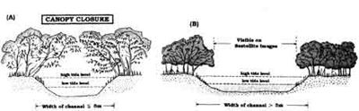
Figure 2 Scematic Cross-Section of Channel in the Sundarbans Mangrove Forests
It should be noted, however, that narrow water systems of less than 5 m wide can be indirectly extracted when considering vegetation and the fact that Gewa grows along saline water systems while Sundri tends to grow away from saline water. This was easily distinguishable on the image by extracting the orange stripes from a green background. Figure 3 shows a plain view illustration of how both species are separated, but are close in symbiosis. The SAR image normally reflects topographic variation rather than the difference of reflectivity, but because of the flat topography, rivers are not clearly represented by the topographic low.
Base Map Creation
The water systems was extracted using only the LANDSAT TM image because of the advantage of detecting water systems of less than 5 m wide in order to generate a seismic base map for 2D reconnaissance survey, rivers or parts of river, which are able to produce reasonable lattice-shaped line programs were chosen from the water system. These rivers that were chosen are finally classified in color on the base map according to the most adequate recording system. Bay cable or Radio Telemetry system. Regardig seismic source, whether or not airgun is workable is highlighted, as shown in Figure 4. Water proof land equipment and dynamic sources are excluded from the above classification because even though they can be used in narrow rivers, their operations would not be efficient.
The second category, i.e. 5-200 m wide rivers, must be further divided because boats for airgun and bay cable deployment are only workable in rivers more than 30 m wide. It should be also noted that images on a scale of 1:20,000 have limitations when trying to select ranges of 5 to 30 m and 30 m to 200 m. In order to improve this, larger scale satellite images or aerial photographs as well as an intensive fields survey would be required.
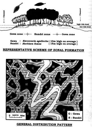
Figure 3 General Habit of Gewa and Sundri Stands
Conclusion
Based upon the above satellite images interpretation as well as some key information obtained on-site, it is concluded that remote sensing technology could be a powerful tool for generating base maps in order to select the appropriate shallow water seismic method in the deltaic area covered with mangrove trees. This is because of its ability to extract water systems directly and with reference to the multi-spectral features of the vegetation.
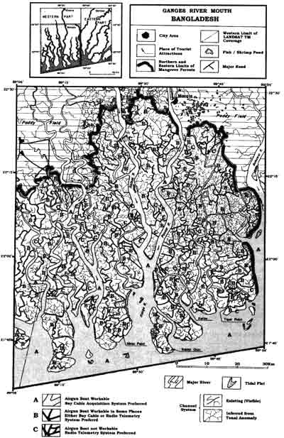
Figure 4 Base Map for Planning Seismic Survey in the Sundarbans Mangrove Forests
Acknowledgments
The authors are grateful to Mr. Toru KAWAKAMI, General Manager of the Department of Research and Development of the Earth Remote Sensing Data Analysis Center, for permission to present this paper. They also would like to thank Petrobangla for their cooperation and assistance during this project.