| GISdevelopment.net ---> AARS ---> ACRS 1997 ---> Global Environment |
Global Access and
Distribution of Geospatial Information: An Operational Reality
John Broadhead and Steve
Smith
MacDonald Detteiler
13800 Commerce Parkway
Richmond, BC V6V 2J3 Canada
E-mail:mailto:jwb@mda.ca%20and%20steven@mda.ca
Web:http://www.mda.ca/
Abstract MacDonald Detteiler
13800 Commerce Parkway
Richmond, BC V6V 2J3 Canada
E-mail:mailto:jwb@mda.ca%20and%20steven@mda.ca
Web:http://www.mda.ca/
Social demands from the environmental and resource management sectors have forced data managers to consider how to provide integrated to remotely-sensed and other complementary spatial data stored in disparate archives, databases and GISs. The problem is not trivial in that Earth observation and other complementary spatial data is noted by its diversity and complexity. A plethora of image and FIS models and that can never be practically converted? These challenges can be geospatial information that is independent of the physical storage structure and semantic context of the stored data.
Land Data BC and CEO Net are two distint system that address these same challenges from different perspectives. Both of these systems are running operationally, providing global access and distribution of geospatial information 24 hours a day via World Wide Web (WWW). Expansion continues as more data sources, value-sdded suppliers and services are added.
Introduction
Over the part few years the Earth observation market has been growing as remotely-sensed data is increasingly combined with other forms of spatial/temporal information and is being used by more people around the world. Until recently, Earth observation data has been exploited mostly by the non-renewble resources sector. As new data sources become available, providing better resolution and higher accuracy, the demand for Earth observation data in the renewable resoure\ces sector is increasing (i.e., agriculture, forestry). Applications areas for remotely sensed data now include non-traditional disciplines such as urban planning, enforcement and insurance - just to name just a few.
Accessing and distribution spatial data has been plagued by the difficulties of identifying what is available, where it is located, how it can be obtained and, once obtained, combining it and using it with other data or applications.
How can organizations provide effective and flexible sharing, exchange and dissemination of data? The solution proposed is an umbrella data management system that connects to existing (heterogeneous) spatial information system. Such a system provides a "single-window" view of remotely-sensed and complementary information while allowing custodians to retain control over their data. The solution offer users and suppliers a single, one-stop access and distribution vehicle for products and services.
The Concept
At the most level, the system provides a common infrastructure on top of the Internet allowing users with varying computing equipment to browse and access data/products. Request desired data and receive the data in selectable formats.
The system leta users know what data/products exists, for what geographic areas and how to get the data, even if the information is part of another Earth observation network. The concept is illustrated below.
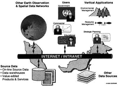
Access to data and value added products is available to anyone with a PC or workstation equipped with Netscape Navigator or Internet Explorer.
After identifying what information is available, the user has the option of requesting the data. If the data is available in a digital form (e.g., an image or map), the requested data will be electronically " delivered" to the user. If the data is not available form (e.g., a study paper, a paper map, an air photo), the request would be forwarded to a custodian that would handle the request manually by post delivery or fax
The architecture is extensible, flexible and expandable, and is adaptable to any organization. This is beyond theory and prototyping for MacDonald Dettwiler who has designed, implemented and delivered a number of geospatial information system. Two of note are:
- LandData BC-a system that provides consistent, uncomplicated access to land-related information held by the various agencies and ministries of the Province of British Columbia, Canada.
- CEONet (Canadian Earth Observation Network) -a Canada-wide spatial data network that provides integrated access to Earth observation archives and other complementary spatial database, both within Canada and internationally.
Land Data BC was born out of the understanding that much of the information required to make good land and resource management decisions already exited within individual ministries and departments of government. Many databases of relevant information existed as "island" throughout government, with no mean so locating particular information, let along accessing or sharing it . these barriers to relizing the full value of the investment into land-related information led to the LandData BC initiative.
Land Data BC is made up of a physical infrastructure of computer, software and communication network plus an organizational structure which manages the cooperation of the data suppliers and the administration of the data consumer (users) accounts.
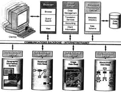
Users of the corporate system employ a common set of services for browsing information about land related data, for requesting data, and for manipulating, joining and displaying retrieved data. They do not need to know where or how the land-related data is stored. In other words, it is irrelevant that, for example, some data may be stored in a GIS, some in a relational database and some in a hierarchical database. This is illustrated below.
At the heart of LandData BC is a metadata repository based on Oracle/SDE(ESRI's Spatial Database Engine) and a sophisticated spatial data model capable of handling the full of Government data holdings. This repository is centralized in order to control the consistency, currency and quality of the information being presented to users. This core repository is integrated with :
- Data access serves for a connection to a wide variety of database (GISs, RDMSs and older legacy system);
- Centralized services for user and access control management;
- Order processing accounting and billing; and
- AWWW base spatial data viewer, called Landscape, enabling universal user access.
The landscape viewer works as an integral part of Land Data BC provides built-in support for a connection to the metadata repository and integration of spatial and attribute information. Landscape allows direct display of a variety of GIS data formats in conjunction with standard java-based WWW browsers. By off-loading the server from user graphic interaction, Landscape allows the spatial data infrastructure to simultaneously support a very large number of users.
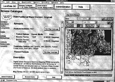
Landscape is implemented as a java applet and directly support of ARC/INFO E00 and Shape data. MapInfo MIF, SAIF and IGDS data. Landscape provides for a full vector-based presentation of GIS data. Standard manipulation of the vector GIS data, such as zoom,pan, feature selection and interative definition of region of interest, is done with the applet on the client desktop. Users can graphically define regions of interest using free form polygons, rectangles, buffer zones on features, and using map feature boundaries. Regions of interest generate spatial-based queries to the server. Raster images in GIF,TIFF and GEOTIFF formats can underlay the displayed graphics and are fully geographically registered with the GIS data.
LandData BC is designed to serve a community of 10,000 users. These include the Provincial Governments, geometric industry, First Nations, land surveyors, universities, local and regional governments, environmental group, utillies, lawyers, real estate appraisers, engineers, land developers, the mining industry as well as the general public.
LandData BC leverhes the value of the Government's existing investment in data, hardware, software and people, Autonomous departments make their information available to third-party users in return for a fee. The cost of providing data is minimized by the development of an automated accounting and billing mechanism. The solution also provides the basis for efficient and cost-effective data translation and integration services. Accounting and access control components ensure that the users community can encompass non-government organizations.
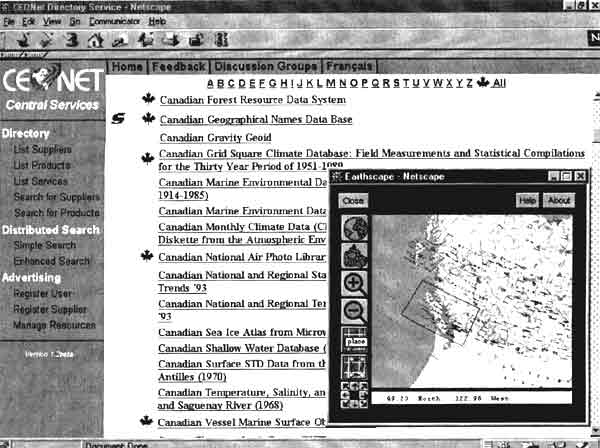
CEONet (http://ceonet.ccrs.nrcan.gc.ca/)
The Canadian Earth Observation Network (CEONet) is an initiative by the Canadian government to create a national infrastructure for providing access to Earth observation archives and other complementary geospatial database. This initiative is being by the requirements of Canadian users for better access to geomantic data, and by the opportunism for Canadian industry afforded by the rapid growth of the international market for geomantic data, services, and network systems.
CEONet is currently in the development stage as a first release and is available to the public. The system currently contains approximately 400 suppliers and 4500 products descriptions, which continue to grow. Distributed search of supplier interface that is implemented over the hypertext protocol (http). Any supplier can register with the system and advertise their products and services for no cost present.
CEONet provides an enabling infrastructure for geomantic information products services (resources). This includes:
- A framework for ubiquitous resource discovery, access, and delivery; and
- Implementation of common (shared) resources.
CEONet supports the development and deployment of value-added services on top of the CEONet infrastructure, such as:
- Simple, stable, standard (common) interfaces;
- Resource changing, grouping, and manipulation;
- Support for workgroup workflows;
- Minimal coat to establish and operate services; and
- Support for marketing (product, pricing, promotion, distribution).
An overview of the architecture is shown below,
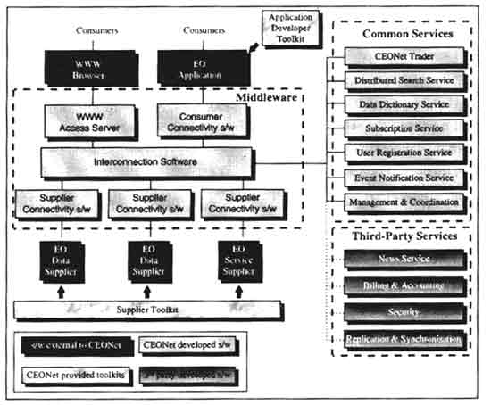
CEONet's enabling infrastructure provides rules and capabilities for consumer/ suppliers' interoperation without delving into the specific site architectures supported by each individual user. The architecture is based on message-oriented middleware. It standardizes the format of requests and supports their management. It is accessed through application programming interface (APIs) which hide details and complexities of implementation from users.
The infrastructure includes interconnectivity software that facilities the connection of user, supplier and services CEONet itself provides a number of common central services, such as search services, directory services and user registration. These services are interfaced by the same means as services provide by third parties, such as news services, billing and accounting services. Finally there is software required at he suppliers sites and the user sites; this software is often site specific, therefore CEONet provides toolkits to maximize reuse across sites, while recognizing that custom connectivity software would also be required.
CEONet can be distinguished from many similar geospatial infrastructures in the following ways:
- Level of support for suppliers: suppliers connecting to the infrastructure can decide at what level to connect- discovering, advertising, evaluating, ordering and delivery of data and services. Suppliers may choose to utilise all or only some of these services in the selling of their products
- Suppliers are responsible for their own data holding management and advertising information : The CEONet architecture does not harvest or gather the suppliers metadata and federate in a central place, but levels the metadata at the suppliers site and managed by each supplier.
- Support for non-expert and expert end user: The interface to CEONet may be through the standard web browsers or sophisticated custom application. This permits various levels of users to use the system in a meaningful manner.
- Breadth of data types being supported (each observation and geomatics data supported)
- Heavy adherence to standards resulting in international interoperability: CEONet provides for interfaces to the European commission's Centre for Earth Observation's Enabling Services plus NASA's EOSDIS. This provides for a common interface for the consumer to not only Canadian data sets, but also to many European and NASA data sets. In addition, because CEONet used the FGDC/GEO metadata standard for distributed inventory searches, the system can immediately interface to the 30 or so data sets that provide these servers in the US, Clearinghouse will be able to integrate into their system the 70 servers to be established in Canada. This integration effort is extremely minimal as the international standard defines a formal interface, which is immediately interoperable between any implementations.
- Chaining of services (i.e. allowing the output of one service to become the input to another service): CEONet has the concept of defining workflows of products and services defined in the infrastructure. This means that value added suppliers can define totally new products by utilizing existing products and services.
- Emphasis on electronic commerce: CEONet intends to utilise industry standard methods of paying for products and services. This will provide both reliability and convenience for and users.
- Distributed nature of the system (objects and services): CEONet is an infrastructure with common services that can be utilised by suppliers. This means that there is less management overhead and that the integration of a supplier is much easier. There is also performance and scalability gains that are achieved through this distributed architecture.
- API interfaces to services and suppliers: CEONet provides programmatic interface to all suppliers and services therefore permitting new applications to use the CEONet infrastructure as well as the human user. The aim of providing this interface is to grow the geomatics industry by enablity new valued added services.
Conclusion
Systems such as LandData BC and CEONet provide proven and effective access to a wide range of Earth observation, geographic information and value-added products and generated by both the public and private sectors. In addition to providing a good business opportunity, provision of such information in an effective manner has a substaintial benefit towards greater utilization of Earth observation and complementary data for resource management, environmental protection and strategic planning. The establishment of more systems with similar capability and interconnecting them is not only being demanded by the user community, it is also viewed as having significant benefit in activities such as global change monitoring and environmental management.