| GISdevelopment.net ---> AARS ---> ACRS 1997 ---> Global Environment |
Global Inventory of Human
Settlements Derived From DMSP-OLS Data
Christopher
Elvidge
Solar-Terrestrial Physics Division
NOAA National Geophysical Data Center
325 Broadway, Boulder, Colorado 80303 USA
Tel. 303-497-6121 Fax: 303-497-6513
E-mail:cde@ngdc.noaa.gov
Yoshiaki Honda
Center for Environmental Remote Sensing
Chiba University
1-33 Yayoi-cho,Inage-ku, Chiba 263 japan
Tel. 81-43-290-3835 Fax: 81-43-290-3857
E-mail:yhonda@rsic.cr.chiba-u.ac.jp
Abstract Solar-Terrestrial Physics Division
NOAA National Geophysical Data Center
325 Broadway, Boulder, Colorado 80303 USA
Tel. 303-497-6121 Fax: 303-497-6513
E-mail:cde@ngdc.noaa.gov
Yoshiaki Honda
Center for Environmental Remote Sensing
Chiba University
1-33 Yayoi-cho,Inage-ku, Chiba 263 japan
Tel. 81-43-290-3835 Fax: 81-43-290-3857
E-mail:yhonda@rsic.cr.chiba-u.ac.jp
The first 1 km resolution global inventory of human settlements is near completion. The product is being assembled using a 1994-95 time series of nighttime visible band observations from the Defense Meteorological Satellite Program (DMSP) Operational Linescan System (OLS). Preliminary results indicate that area lit is highly correlated to measures of economic activity, such as Gross Domestic Product (GDP)
Introduction
Much of global change research is dedicated to discerning and documenting the impacts of human activities on natural systems. Human population numbers have expanded from ~750 million in the mid-1700's to 5.8 billion in 1996 and are expected to double in the next 45 years. Human activities which are known to be cumulatively altering the global environment include greenhouse gas emissions from fossil fuel consumption, air and water pollution, and land cover/ land use change. Far from being evenly distributed across the land surface, to a great extent human activities with environmental consequences are concentrated in the vicinity of human population centers. As a contribution to global environmental research, we are producing a satellite data derived map of human settlements at 1 km resolution.
Materials and Methods
The DMSP-OLS has a unique capability for the global observation of fires and human settlements. The primary function of the DMSP-OLS is to provide global imagery of cloud cover. At night the observed visible near infrared (VNIR) radiance is intensified, for the purpose of cloud detection using moonlight. In addition to moonlit clouds, the light intensification makes it possible to detect VINIR emissions emanating from the earth's surface, from cities, towns, industrial sites, gas flares, and ephemeral events such as fires and lightning. NDGC serves as the nation's long term archive for DMSP data. NGDC currenly receives 7.4 gigabytes of raw DMSP data per days using a dedicated T-1 line to the U.S. Air Force, Offutt Air Base, Omaha, Nebraska. Data transfers occur automatically, as readouts are received by Offutt, and arrive on the NGDC computer within 1-2 hours from the observation time (longest delay comes from the time gaps between successive readouts of the on-board tape recorders). At NGDC the data are deinterleaved and written out to archive tapes. Our near-real-time global DMSP data stream, ingest, preprocessing, and product generation are analogs for EOS-MODIS. It is anticipated that the DMSP -OLS data stream will continue to flow to NGDC until 2010 or anticipated that the DMSP-OLS data stream will continue to flow to NGDC until 2010 or even 2015. The nighttime low light imaging capabilities of the OLS will be continued even 2015. The nighttime low light imaging capabilities of the OLS will be continued in the combined DoD -NOAA polar orbiting meteorological satellite program (NPOES).
We have developed algorithms for mapping fires, human settlements, and gas flares using time series of nighttime DMSP-OLS observations (Elvidge et al., 1997a). NGDC is currently completing the first systematic global inventory of human settlements based on satellite observations. NGDC has completed a five year (1992-96) nightly inventory of fires in Madagascar for the U.S. AID using DMSP-OLS data. The core set of algorithms and details regarding the sensor and data characteristics are described in Elvidge et al. (1997a). This reference can be viewed at the "Nighttime Lights of the World" (http://WWW.ngdc.noaa.gov: 8080/production/html/BIOMAS/night.html). NGDC is completing a global inventory of stable lights using a times series of nighttime OLS observations from 1994-95. Imagery are only used from the dark half of each lunar cycle to avoid problems with moonlight clouds and moonlight reflections of water bodies.
Results
The stable lights are produced in the 1 km equal area grid of the Interrupted Goode Homolosine Projection (IGHP), but are subsequently converted to a 30 arc second latitude-longitude grid. The stable lights product reports the percent frequency with which lights were observed in each grid cell within the set of cloud-free OLS observations. Total number of OLS observations typically in the 70-120 range across all land masses. Number of cloud-free observations in the range of 40-80, except in the most cloud impacted regions. By normalizing for variation in the number of cloud-free observations, it is possible to compare results in different regions. A frequency threshold of 6 to 10% is applied to remove fires and other ephemeral events. Features include the lights from cities, towns, villages, industrial sites, fishing boats and gas flares. Field checking in the USA indicates that towns as small as 120-200 people can be detected. Examples of stable lights products from Asia are shown in Figures 1 and 2. As a final step in assembling a global map of human settlements, NGDC will edit the stable lights to remove gas flares, fishing boats and other features which are not associated with human settlements.
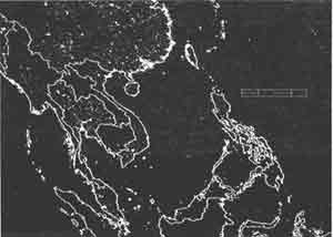
Figure 1: Stable lights from cloud-free portions of DMSP-OLS observations from 1994-95 for a major section of Southeast Asia. Scale bar is 1000 kilometers in length.
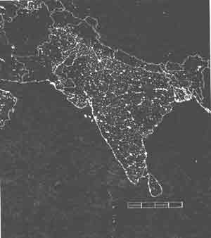
Figure 2: Stable lights from cloud-free portions of DMSP-OLS observations from 1994-95 for India and adjacent areas. Scale bar is 1000 kilometers in length.
The relation between area lit, derived from the DMSP-OLS stable lights products, population, and economic activity for 52 countries are shown in Figure 3 (see Elvidge et al., 1997b and c). There is a generally linear relationship between area lit and population, with the area lit expanding as population increases. Visually evident outliers with anomalously high area lit relative to population include the USA, Norway, Sweden, Finland, and Iceland. Outliers with low area lit values relative to population include: China, India, Georgia, Moldova, Albania, and Armenia. A more linear relation emerges when area lit is plotted against GDP, indicating that the extent of lighting is closely tied to the level of economic activity.
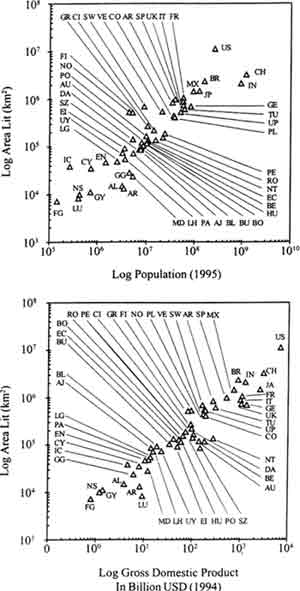
Figure 3: Area lit from 1994-95 DMSP-OLS stable lights versus population and Gross Domestic Product for 52 countries. Note log-log scale.
Conclusion
We report on progress towards the completion of the first satellite based global inventory of human settlements, derived from nighttime data from the Defense Meteorological Satellite Program (DMSP) Operational Linescan system (OLS ). The DMSP-OLS has a unique capability to observe faint sources of visible-near infrared emissions present at the Earth's surface, including cities, towns, villages, gas flares, and emissions present at the Earth's surface, including cities, towns, villages, gas flares, and fires. NGDC receives global coverages of DMSP-OLS data in near real time and has developed algorithms for producing georeferenced fire and human settlements products. The global human settlement product is being assembled at 1 km resolution using a time series of DMSP-OLS observations spanning the 1994-95 time period. Data applications which are being explored include the spatial apportionment of human populations, fossil fuel trace gas emissions, urbanization impacts on food production, and urban heat island effects on meteorological records.
Reference
- Elvidge, C.D., Baught, K.E. Kihn, E.A., Kroehl, H.W, Davis, E.R, Davis, C., 1997, relation between satellite observed visible-near infrared emissions, population, and energy consumption. International Journal of Remote Sensing, v. 18, p. 1373-1379.
- Elvidge, C.D., Baught, K.E., Kihn, E.A., Kroehl, H.W, Davis, E.R, 1997, Mapping of city lights using DMSP Operational Linescan System DATA. Photogrammetric Engineering and Remote Sensing, v. 63, p. 727-734.
- Elvidge, C.D., Baught, K.E., Kobson, V.H., Kihn, E.A., Kroehl, H.W., Davis, E.R., Cocero, D., 1997, Satellite inventory of human settlements using nocturnal radiation emissions: A contribution for the global toolchest. Global Change Biology, In Press.