| GISdevelopment.net ---> AARS ---> ACRS 1997 ---> Geology |
Analysis of Remote Sensing
Data for Geologic Mapping - Ultrahigh Pressure Metamorphic Belt and
Collisional Tectonics of The Dabieshan Orogenic Belt, Central Eastern
China*
Zhang Wenhua, Zhao
Zhongyan, Wang Changjiang
Laboratory of Lithosphere Tectonic Evolution, Institute of Geology,
Chinese Academy of Sciences, Beijing 100029, China
Tel: (86)-010-6202-7766 Fax : (86)-010-6237 5167
He Guojin, Ho Deyong
Chinese Satellite Ground Station, Chinese Academy of Sciences,
Beijing, 100086, China. Tel : (86)-010-6255-9679
Abstract Laboratory of Lithosphere Tectonic Evolution, Institute of Geology,
Chinese Academy of Sciences, Beijing 100029, China
Tel: (86)-010-6202-7766 Fax : (86)-010-6237 5167
He Guojin, Ho Deyong
Chinese Satellite Ground Station, Chinese Academy of Sciences,
Beijing, 100086, China. Tel : (86)-010-6255-9679
Processing methods were tested to effectively enhance the spectral and spatial information of the images. The image processing approach used in this study revealed previously unrecognized major structures and some lithologic units. Geological evidences showed the Dabieshan mountain is characterized by four linear tectonic belts trending NWW, which formed during tectonic collision between Sino-Korean and Yangtze plates in the Triassic Magnetotelluric survey revealed that a major decollement at 15-20 km depth runs 150 km directly underneath the Dabieshan. Above the decollement, the four tectonic belts formed a series thrust sheets and accommodated all the deformation. Below the decollement relatively intact Yangtze plate underthrust the Dabieshan over 200 km from the foreland fold and thrust belt of the Yangtze to the Northern Haiyang belt of the Sino-Korean plate.
Introduction
The study area is located at the Southwestern Anhai Province (Fig. 1). Dabieshan is one of the few orogenic belts in the world where diamond-and coesite-bearing ultrahigh pressure (UHP) metamorphic rocks are found in crustal environment (Wang et al., 1989; Okay et al., 1989; Xu et al., 1992). In the last a few years, studies in detail by geologists from many countries have given a good views (e. g. Okay et al., 1989; Wang, et. al., 1992; Li et al., 1989, 1993; Cong, 1996; Zhai, 1996).
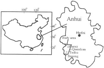
Fig. 1. Location of the studied area in Dabieshan, Anhui Province Eastern China.
High ground resolution satellite imagery has been used to detect Dabeishan tectonic units. Therefore, when examining a Landsat TM image or aerial photographs of the Dabeishan, a number of northwest-southeast and northeast trending liner features can be observed.
In this paper we provide our present knowledge of the UHP metamorphic belt, regional geology and deep structures of the Dabieshan revealed by Magnetotelluric survey, Remote Sensing data and discuss the tectonic units and evolution of the Dabieshan organic belt.
Tectonic belts of the Dabieshan
Dabieshan is a part of the salient Kunlun-Qinling-Dabie-sulu (Shandonog-Jiangsu) orogenic belt in central China running over 5000 km east-west. In eastern China the Qinling-Tongbai-Dabie-Sulu orogenic belt separates the Sino-Koean plate in the north from the Yangtze plate in the south. Dabieshan is structurally bounded on the east by Tanchang-Lujiang fault (T-L-F.), on the west by Shangcheng-Macheng Fault (S-M F.) (Fig. 2). To the north of Dabieshan is Hefei Basin, a Mesozoic and Cenozoic sedimentary basin. To the south is foreland fold and thrust belt of the Yangtze plate. The Dabieshan may be characterized by four E-W trending tectonic belts, the northern Huaiyang belt, the Northern Dabie magmatic arc complex, the Southern Dabie UHP metamorphic belt and the Susong Metamorphic belt (Fig. 2). Each of the belts is separated from the others by major faults.
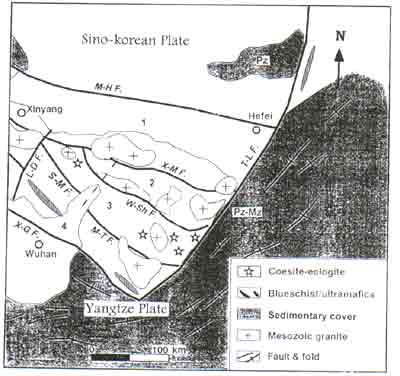
Figure 2. Sketched tectonic map of the Dabieshan Mountains (Simplified from Cong, 1996).
Legend
faults
L-D F. Lushan-Dawu fault, W-Sh F. Wuhe-Shuihou fault, T-L F. Tanchang-Lujiang fault, M. T. F. Majiao-Taihu fault, S-M F. Shangcheng -Macheng fault, M-H F. Maoji-Hefei fault, X-G F. Xiangfan-Guangji fault, X-MF. Xiantian-Mozitan fault.
Pz:Paleozoic group,
Mz :Mesozoic group
tectonic belts:
1. North Huiyang Backarc Flysch belt,
2. North Dabieshan Arc Complex belt,
3. South Dabieshan Collision Complex belt,
4 Susong Metamorphic Complex belt.
1. The Northern Huaiyang belt
The Northern Huaiyang is an E-W trending liner belt to the north of Xiaotian-Mozitan Fault (X-M F.) and is partly covered by Mesozoic and Cenozoic none-marine clastic sediments and volcanic of the Hefei Basin on the north.
2. The Northern Dabie magmatic arc complex belt
The Northern Dabie complex is separated from the Northern Huaiyang by the X-M F. on the north and from the UHP belt by a duclite shear zone on the south. It is characterized by polyphase igneous intrusion, migmatite and amphibole to granulite faces metamorphic rocks.
3. The Southern Dabie ultrahigh pressure metamorphic belt
Coesite-and diamond-bearing ultrahigh pressure metamorphic rocks found in a belt of about 30 by 50 km to the south of the Northern Dabieshan complex. They occur in three modes: coesite eclogite lenses in marble; elclogite lenses and layers in gneisses and eclogite associated with garnet peridotite.
4. The Susong Metamorphic Complex belt
To the south of the UHP belt in 80 km wide belt composed of a thick sequence of metasediments and metavolcanics named Susong Group (Bureau of Geology and Mineral Resources of Anhui Province, 1987). The Susong Group consists of two lithological units: cold eclogite unit and greenschist unit.
Data structures from magnetotelluric survey
Magnetotelluric survey across the Dabieshan was done by the Anhui Geophysical Survey. One of the major features revealed by the survey is a major low resistivity layer (MLRL) of 5-30 ohm-meters (Wm). Above the MLRL the Dabieshan is clearly composed of several thrust sheets of contrasting resistivity. The structurally highest sheet has a resistivity of 25600-110000(Wm). The second sheet lies below the first, has a resistivity of 8000-15000(Wm). This sheet crops out as an arrow belt is probably equivalent ot the UHP belt. The third thrust sheet lying below the UHP sheet has a resistivity of about 15000-35000 (Wm). The lowest thrust sheed extends 100 km as Sinian sedimentary rocks of the Yangtze plate. These geophysical observations are record deep structures which might not be constant with the surface geological configuration.
Methodology and Analysis of space imagery Dabieshan UHP belt
The TM scene was acquired on 23 April, 1988. The image cover a 80 x 80 km, with 30-m ground resolution (Fig. 3). Methods of classification using multispectral data are of little use to map them. Therefore, computerized methods are able to process systematically and small detail. The methodology of filtering detailed here has been tested on a TM subscence located cartel of the Northern Dabieshan complex belt. Filtering techniques are generally used to assist visual interpretation.
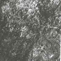
Figure 3: Landsat TM image colour-compesite, with bands 4, 5 and 3 displayed as red, green and blue. (print by monochromatic printer).
On aerial photographs and satellite images, the faults appears linear scares across the landscape. The main NE striking fault zone and NW faults are well shown on the image (Fig. 3). They evidence a coherent parallel NW striking fault system, located in between the NE striking major faults. Within the fault zone, various geomorphic features related to the pronounced horizontal movement can be observed. The deformation in this area is characterized by major faults trending NE-SW. The major trending fold axes in sediment cover is NE-SW and E-W.
We also can be cound very distinct on the images as a sort of special lineaments. They are geologic body extending in a shape of arc or ring. The structures are generally formed by the deep movement of magmatic rocks and mantle domes. The features suggest: It may be consists with the geophysical observance data.
Tectonic Evolution
They Yangtze plate was close to the equator during the Paleozoic as revealed by paleomagnetic study (Seguin and Zhai, 1993). The Sino-Korean plate was also in the equatorial region but as a different longitude in the Paleozoic and drifted to the north of Yangtze plate in the Carboniferous (Wu et al., 1990). This suggests a paleo-ocean once existed between the two plates in the Paleozoic. Based on isotopic chronology of UHP metamorphic rock (Li, 1993; Cong, 1996) and our geological and geophysical observation, we suggest a two stage exhumation mode of the UHP rocks; breakback thrusting and mantle doming. The breakback process produced a series thrust sheets and a major decollement surface in the subducting plate, and quickly brought te UPH rocks from mantle depth to a middle crust level. The second stage exhumation was related to regional extension due to mantle doming beneath the Hefei basin in the Jurassic to Cretaceous Continuous erosion and uplift of the Dabieshan coupled with deposition of the eroded material in the Hefei Basin through Cenozoic and Mesozoic times have brought the UPH rocks to the surface.
Conclusion
Major linear features are observed on Remote Sensing images of Dabieshan Mountains. These lineaments dissect the Dabieshan oroganic belt. The Geological evidences suggest the Dabieshan is characterized by four linear tectonic belts, that were formed during early Triassic collision between the Sino-Korean and Yangtze plates. The Geomorphic evidence points to the notion that these features may be the surface expression of major faults in the Dabieshan.
The filtering techniques have facilitated interpretation of the images. The processing techniques can be used in different ways. Combined the geophysical data, processing Remote sensing images and surface observation, a sketch structure and petrological units map could be mapping.
References
- Bureau of Geology and mineral resources of Anhui, 1987, Regional Geology of Anhui Province, Geological Publishing Houses, Beijing, China
- Cong, B. (editor) 1996, Ultrahigh-Pressure Metamorphic Rocks in The Dabieshan-Sulu Region of China. Sciences Press, Beijing, China.
- C. Mering, D. Huaman-Rodrigo, J. Chorowicz, B. Deffontaines and R. Guillande, 1996, New data on the geodynamics of southern Peru from computerized analysis of SPOT and SAR ERS-1 images. Tectonophysics, 259 p. 153-169
- Freek Van Der Meer, 1996, On the possible role strike-slip related tectonics in the Renda-Malanga area (South Spain). ITC Journal, 2, p. 131-148.
- Li, S. G, Xi, Y. L., Liou, D. L., Chen, Y. Z. and et al., 1993, Collision of the north China and Yangtze Blocks and formation of Coesite-bearning eclogites: Timing and processes. Chemical Geology, 109, p. 89-111.
- Okay, A. I., Xu, S. T. and Sengor, A. M. C., 1989, Coesite from the Dabie Shan eclogites, central China. European Journal of Mineralogy, vol. 1, p. 595-598.
- Okay, A. I. and Sengor, A. M. C. 1992, Evidence for intercontinental thrust-related exhumation of the ultra-high-pressure rocks in China. Geology, vol. 20, p. 411-414.
- Seguin, M. K. and Yongijan Zhai, 1992, Paleomagnetic constraints on the crustal evolution of Yangtze block, southeastern China. Tectonophysics, vol. 210, p. 50-76
- Wang, X., Liou, J. G. and Mao, H. K., 1989,Coesite-bearing eclogite from Dabie Mountains, central China. Geology, vol. 17, p. 1085-1088.
- Wu, H., Zhau, R., Liu, C. and Chang, C., 1990, Paleomagnetic observation in North China Block from Late Paleozoic to Triassic. Acta Geophysical Sinica, vol. 33, p. 694-701.
- Xu, S. T., L. Ziang , Y. Liu and Y. Zhang, 1992, Tectonic framework and evolution of the Dabie Moutons in Anhui, Eastern China. Acta Geology Silica, vol. 66, p. 1-14.
- Zhai, M., Cong, B., Zhao, Z. Y., Wang, W. and Wang, G., 1995, Petrological-tectonic units in the coesite-bearing metamorphic terrain of the Dabie Mountains, central China and their geotectonic implications. J. SE Asian Earth Sci., 11, p. 1-13.
- Zhang, Z., 1992, Dolomie-bearing coesite-bearing coesite eclogite in Yuexi area of Anhui Province. Acta Petrologica Sinica, vol. 8, no. 1, p. 97-102.