| GISdevelopment.net ---> AARS ---> ACRS 1997 ---> Geology |
The Correlation of the
Landsat TM Images Characteristic with the Geologic Information : A
Preliminary Result of a Case Study in Langkawi Islands, Malaysia
Ibrahim Abdullah &
Juhari Mat Akhir
Department of Geology
Faculty of Physical and Applied Sciences
Universiti Kebangssan Malaysia
43600 Ukm Bangi, Malaysia
Tel: 6-03-8292392 Fax. 6-03-8292490
E-mail :iba@pkrisc.cc.ukm.my
Abstract
Department of Geology
Faculty of Physical and Applied Sciences
Universiti Kebangssan Malaysia
43600 Ukm Bangi, Malaysia
Tel: 6-03-8292392 Fax. 6-03-8292490
E-mail :iba@pkrisc.cc.ukm.my
Satellite data is commonly used in helping the geological mapping and interpretation in arid and semi-arid region. However, in tropical area which is covered by dense vegetation and thick soil, the used of satellite data in such mapping is said generally to be vary difficult to success. To test the perception, Langkawi Islands which is geologically has been mapped in quite detail is selected. The Landsat Thematic Mapper (TM) data of the area is processed digitally to exhibits its geological information. The characteristics of the produced images are carefully studies and correlated to the lithological units in the islands.
The Langkawi Islands consists of four rock formations. The oldest, known as Machinchang Formation consists of mainly quartzite and subordinate flagstone. This formation is conformably overlain by the Setul Formation which is compose of mainly limestone with minor sandstone and shale. The Singa Formation which is consists of mainly mudstone and shale with minor sandstone unconformably overlain the Machinchang and Setul Formations. The youngest rock formation is known as Chuping Formation consists of limestone (dolomitic), conformably overlain the Singa Formation. In addition to these formation, granite is also widespread in the islands.
To test the capability of the satellite data in exhibiting the geological information of the area, the digitally processed Landsat TM images were compared to the published geological map. It is found that the colour composite of the Landsat TM band 432 displays in red, green and blue respectively exhibit the overall best correlation between image characteristics and geological information in the area especially in discriminating the limestone area from other rock units. Further more, the colour composite images of the Landsat TM bands 452 and 457 are also show a quite different characteristics in terms of colour and texture which could directly be correlated to the lithological units of the area. Other than lithology, the Landsat TM images are also exhibit a number of major lineaments which represent faults. The results from the preliminary study show that it is clear the characteristics of remote sensing data, in this case the Landsat TM images are well correlated with most geological information (lithology and structure), and have a great potential to be used in general geological mapping of the area which is largely still covered by naturally vegetation and less disturbed by the development.
Introduction
Satellite image which shows a wide coverage of certain area permits the recognition of big scale geological features such as folds, faults and rock formation boundaries. Further, all these features could be traced and mapped. Digitally processed data will provide better images, as compared with hard copy of so-called standard image product for geological interpretations (Anuta, 1977; Condid & Chavez, 1979).
In Malaysia, the use of satellite data for geological interpretations are still lacking compared to other fields. Among other reasons cited is the nature of our tropical terrain with heavy vegetation and thick soil cover. Under this situation, it is difficult to differentiate the rock units of the area especially when the rocks are deeply weathered, covered by near surface material, alluvium, or insitu soil or vegetation of not strata related. Such conditions were used by many people to exclude the used of remote sensing technique in geological interpretation especially to map the rocks distribution in tropical area including Malaysia. They believed, it will be very difficult for this technique to produce any satisfactory result. However, the vegetation anomalous and the geomorphological appearance which are related to the rock types, quite frequently could be seen or detected in satellite image. Under these circumstances, the lithologic unit of the area could be differentiated. In these relations, some of the positive results about the use of satellite data for geological interpretation in Malaysia were already shown (Juhari, 1990 and 1996; Nor Bakri, 1993; Azli Kamil et. al., 1996 and Noraini Surip et. al., 1996).
One of the purpose of this study is to test the general perception that the use of remote sensing images for geological study in tropical area is very difficult to reach a satisfactory result. Langkawi Islands is selected as the study area since the geology of the area is already established. Therefore, it is very convenience to complete the satellite data characteristic of the area with the geological information observed in the field.
Data and study area
Satellite Data
Satellite data (Landsat TM) used in this study are parts of frame 128/56 in the international reference system which were recorded in 1989, covering most of Langkawi Islands which is situated in the north-west of Malay Peninsula. The data were recorded and kep in computer compatible tape (CCT).
General Geology and Strartigraphy
The geology (rocks distribution) in Langkawi Islands and general stratigraphy (rock sequence) of the area is shown in Figure 1. The oldest rock formation in this area is known as Machinchang Formation, consists of mainly sandstone (quartzite), conglomerate and greywacke in the upper parts and shale, mudstone and subgreywackes in the lower parts of the sequence. This rock formation outcrops in the north-western part of the Langkawi mai island. The age of this formation is assigned as Late Cambrian (Jones, 1981) or Cambro-Ordovician (Lee, 1983). This rock formation forms medium textured to quite rugged topography and well defied ridges. The area is moderate to densely covered by vegetation.
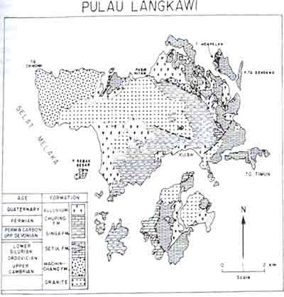
Figure 1 Geology and general stratigraphy of Langkawi Islands. Malaysia.
Mechinchang Formation is conformably overlain by Setul Formation which is consists of mainly limestone (marble) and characterized by karst topography. Towards the top of the sequence of the formation, two detritus strata are present and known as the Lower and the Upper Detrital member. This formation outcrops in the east of Machinchang Formation near Teluk Kuban Badak and the eastern parts of Langkawi Islands including Pulau Dayang Bunting (eastern part), in the south, Pulau Tuba, Pulau Timun, Pulau Tg. Dendang and Pulau Langgun in the north. The age of the formation is interpreted as Ordovician to Early Devonian. This limestone area froms karstic topography, characterized by isolated, steep slope and very rugged topography surrounded by alluvium. The area is covered by thin soil and barren to slightly covered by vegetation especially in dry season.
Singa Formation unconformably overlain the lower paleozoic rock. It consists of mainly black mudstone and siltstone with interbedded-sandstone layer of late Ordovician to early Permian (Jones, 1981). This formation is outcropped in the east of Gunung Raya and many small islands including Pulau Rebak, Pulau Kentut, Pulau Tepur, Pulau Beras Basah and Pulau Singa in southern part of Langkawi Islands. This rock formation ios characterized by rolling and quite smooth topography. Generally the area is covered by thick soil and dense to very dense vegetation.
Chuping Formation conformably overlain Singa Formaion. It consists of relatively pure, lighter colour and thickly bedded to massive limestone of Permian age. This rock formation was metamorphosed to marble and outcrops in the western part of Pulau Dayang Bunting. This rock formation is gently dipping towards east and relatively developed thicker soil as compared to the limestone area of Setul Formation.
Other than the rock formations mention above, igneous rock granite is also present. The main intrusion forms the highest peak in Langkawi Island known as Gunung Raya. Other granite forms a prominent ridge align in north east direction from Teluk Borau in south-west to Pasir Hitam (north-east), a small ridge east of Kuah town, circular hill north of Pulau Dayang Bunting and western part of Pulau Tuba to Pulau Bumbon. A low undulating hill near south of Padang Mat Sirat is also consists of granite. Generally the granite areas show relatively smooth topography with granite to moderate slope gradient . This type of topography is covered by thick soil and dense vegetation.
Alluvium, mainly of marine origin is occupying the south-western part (Pantal Cenang and Pantal Tengah), around Kuah town and the area in between the limestone hill in the north-east of Langkawi main island. Alluvium is also present in the middle part of Pulau Tuba and some parts of Pulau Rebak Beesar. Most of alluvium areas around Kulah and Pantai Chenang in Langkawi main island and Pulau Tuba were developed into residential or agricultural. The alluvium area in the north-east of Langkawi main islands is relatively untouched and covered by thick mangrove.
Data processing and image products
It is quite difficult to detect the difference of grey tone in black and white image which could be related to he differences in near surface material and other geological information. As a result the materials or rocks with slight different in colour may give same appearance in grey tone image. The same information, if it is displays as colour image is possible detected by our eyes since the sensitivity of our eyes to colour is much higher than the grey variation scale. For that reason, in this preliminary study, a special emphasis is given to the production of colour composite images by combining any three bands of Landsat TM data.
Based on colour variation and the geological information which is displayed, three colour composite images were selected for this study, i.e., colour composite TM bands 432, 452 and 457 . The data of every bands were corrected for the atmospheric effect before the composite images are produced for this study.
Results and Discussion
The characteristic of every images produced were carefully observed and inspected to obtain any relationship with the geology (lithology) of the area. As a result, a number of image characteristics were recognized which could be used to compare the image of a certain lithologic unit with others. The result of the observation on TM image characteristics with relation to the geologic units is summarized in Table 1.
| Image Characteristic | Morphological Expresion | Cover | Geological Correlation | |||||
| Colour | Texture* | Rock Unit Properties | ||||||
| BCC 432 | BCC 457 | BCC 452 | B5 | Resistance | Jointing/li nea-ment | Cultivation | Vegetation | Mapped Formation/lithology |
| Dark red | Brownish red | Orange red | Smooth and fine | Very low | None | Intense | Dense with mangrove | Aluvium/unconso-lidated sediment |
| Red and dark pink | Brownish orange | Greenish orange | Coarse, rough with few ridges | High | Medium density with one set of jointing | None | Sparse to moderate | Chuping Formation/lime-stone |
| White with spotted light blue and pink | Light blue | Light blue with spotted orange | Moderate smooth | Low to medium | Very low density | Intense | Moderate | Singa Formation/mudstone siltstone |
| Light blue green | Brownish light blue | Greenish orange | Rough surface and coarse | High | Med density with 2-3 set of jointing | None | None to sparse | Setul Formation/limestone |
| Red | Reddish orange | Yellowish orange | Medium to coarse, dissected | High | Medium density | None | Dense | Machinchang Formation/quart-zite, greywacks |
| BCC - band colour
composite * based on the black and white image of TM band 5 | ||||||||
It is found that the satellite image characteristics are closely related to the geology (lithology) of the study area. This relationship could be considered as a positive result in the effort to use the satellite data in helping geological mapping. Among the clear and apparent relationship are:
- limestone terrain, especially limestone of Setul Formation which displays light blue-green colour in TM 432 colour composite image and clearly different form othe ligholigic units.
- granite terrain which displays deep red colour in TM 432 colour composite image and coarse texture.
- Machinchang Formation terrain which displays red colour (almost similar to granite terrain except its texture is finer and dissected) in TM 432 colour composite image.
- Singa Formation terrain which displays white with spotted light blue and pink colour for low lying topography and pink colour is hilly topography.
- alluvium terrain which is covered by mangroves displays dark red colour in TM 432 colour composite images and fine texture.
- terrain made of Chuping Formation displays red and pink colour with light blue mottled in TM 432 colour composite image and coarse texture.
Other that the relationship with the lithologic units a number of lineaments are also recognized and traced from these satellite images which represent geological faults of the area.
As the conclusion, the result of preliminary study which tries to see the relationship between the image characteristics of Landsat TM colour composite and the geological information of the area selected shows a very good correlation. This mean that, the general perception about the difficulty and non-suitability of using the satellite data in geological mapping in such area like Malaysia is not really true especially in Langkawi Island. We believe, by using or applying a further processing techniques such as rationing method, textural analysis, filtering and hue-saturation-intensity transform, the result will be better and more positive. Further more, it is expected that a geological mapping (rock distribution) in Langkawi Islands could be done by unsupervised or supervised classification techniques with a satisfied degree of accuracy.
Acknowledgments
We like to thanks Mr. Ibrahim Mohd Dom for helping in map preparation. This study is funded by Kementerian Sains, Teknologi dan Alam Sekitar through IRPA program no 02-02-02-0006. To the head of the program, Prof. Dr. Ibrahim Komoo, special thank to due for allowing us to present this result.
References
- Anuta, P. E., 1977. Computer assisted techniques for Remote Sensing data interpretation Geophysics. Vol. 42: p468-481.
- Azlikamil Napiah, Nguyen Ngoc Thach, Adnan Ismail & Nik Nasruddin Mahmood, 1996. Geological and mineral prospecting in Kuala Kelawang area using remote sensing and GIS techniques. Proceedings of the First Malaysian Remote Sensing Society Conference on Remote Sensing and GIS. Kuala Lumpur 25-27 November 1996: 11-18.
- Condid, C. D. and Chavez, P. S., 1979. Basic concepts of computerized digital image processing for geologist. U. S. Geological Survey Bulletin 1462 L 16p
- Juhari M. A., 1990. Tafsiran geologi imaj satelit: kajian awal menggunakan data dari Malaysia (Geological interpretation of satellite images: preliminary study using Malaysian data). Technical report FSFG, UKM Vol. 4, 1990: 48-75.
- --------, 1996. Geological applications potential of satellite multispectral scanner satellite data in Malaysia: a Kedah-Perak case study BORNEO SCIENCE , 2: 1-19.
- Jones, C. R., 1981. Geology and mineral resources of Perlis, north Kedah and Langkawi Islands. Geological Survey Malaysia, District Memoir 17: 257 p.
- Lee, C. P., 1983. Stratigraphy of the Tarutau and Machinchang Formation. Proc. Workshop on Stratigraphic Corr. Of Thailand and Malaysia, Vol. 1: p. 20-37
- Noor Bakri Endut, 1993. Pemetaan lineamen (struktur) geologi kawasan Penjom, Pahang dengam menggunakan teknik penferiaan Jauh. Program dan abstrak seminar Penggunaan Data Penderiaan Juah Dalam Sains Bumi di Kawasan Tropika. Universiti Kebangsaan Malaysia, Bangi, 15-15 Disember, p. 30.
- Noraini Surip. Azlikamil Napiah, Jasmi Talib and ku Mohd. Noh Ku Ramli, 1996 Geological mapping of north-east Selangor area using remote sensing techniques. Proceedings of the First Malaysian Remote Sensing Society Conference on Remote Sensing and GIS, Kuala Lumpur 25-27 November 1996: p 1-16.