| GISdevelopment.net ---> AARS ---> ACRS 1997 ---> Geology |
Geological Applications of
LANDSAT Thematic Mapper Imagery: Mapping and Analysis of Lineaments in NW
Penisula Malaysia
Juhari Mat Akhir and
Ibrahim Abdullah
Department of Geology
Faculty of Physical and Applied Sciences
Universiti Kebangssan Malaysia
43600 Ukm Bangi Malaysia
Tel. 6-03-8292661 Fax. 6-03-8292490
E-mail :jma@pkrisc.cc.ukm.my
Abstract
Department of Geology
Faculty of Physical and Applied Sciences
Universiti Kebangssan Malaysia
43600 Ukm Bangi Malaysia
Tel. 6-03-8292661 Fax. 6-03-8292490
E-mail :jma@pkrisc.cc.ukm.my
Remotely sensed lineaments are often used as indicators of major fractures in near-surface. Earlier, lineament interpretation were made from aerial photographs. Recently, geologists have been interested in tracing lineaments from satellite images which have broad coverage under the uniform conditions. The Landsat Thematic Mapper TM which is covering part of north-west of Peninsula Malaysia have been digitally processed to enhance the visibility of lineaments. The contrast stretched of TH band 4 was found to be the best in displaying lineaments for the area, hence was further processed by using directional filters. The directionally and non-directionally filtered images together with the contrast stretched image of TM band 4 were used for lineament mapping and analysis for the study area. After tracing all lineaments, their orientations and lengths were determined and measured, and then analysed by preparing rose diagrams for analysis, interpretation and comparison with the published geological map. A lineament map with a scale of 1: 250, 000 of the study area is presented here, which is derived from the processed TM images.
This study indicates that he Landsat TM data is useful for locating and interpretation of the lineaments in the area. Geologic features, particularly lineaments, are readily interpreted despite dense vegetation cover. The study has shown that remote sensing data such as Landsat TM can be used in locating new in addition to previously known features, probably faults, which may be of economic importance in the area. Hence, lineament mapping and analyses from satellite data of the area can provide a new, rapid and stimulating overview for regional structural (lineament) study for mineral exploration, locating of new mineral deposits and planning the development of the selected area.
Introduction
The purposes of this study are (1) to show the applicability of the remote sensing data in structural geological study (lineament) in Malaysia; (2) To evaluate the images produced by several enhancement techniques for lineaments mapping; (3) To prepare structural map (lineament) based on the remote sensing data interpretation, then compared to the published geological map, and (4) to produce structural map (lineament), probably showing some newly discovered lineament which is subsequently may be used as a reference in future geological mapping. This paper presents the result of study on the lineaments from an area in north-west Malay Peninsula which are extracted and interpretated from digitally enhanced Landsat. Thematic Mapper images.
Term lineaments was originally used by Hobbs (1904) in his paper entitle "Lineaments of the Atlantic border region". He defined lineaments as significant lines of landscape that reveal the hidden architecture of the rock basement. However O'Leary et. al. (1976) defines lineament as a mappable, simple or composite linear feature of a surface whose parts are aligned in a rectilinear or slightly curvilinear relationship and which differ from the pattern of adjacent features and presumably reflects some sub-surface phenomenon. The definition by O'Leary is applied in this study.
In the past, lineaments interpretation were done based on the information extracted from air-photograph. Lately, satellite images were more frequently used for this purpose. However, in Malaysia the Landsat images used in geological mapping and lineaments interpretation are produced from non-digitally enhanced data (Foo, 1976); Sudrajat, 1978; Raj, 1882; Tjia & Zaiton, 1985; Almashoor & Tijia, 1987; Tijia, 1989 and Lai 1990). The benefits of using digitally processed satellite data are very well known and shown by several workers (Rowan et. al., 1974; Siegel&Abram, 1976; Condit & Chaves, 1979; Blodged & Brown, 1982 and Rothery, 1985). For that reason, in the more recent work, enhanced digitally processed satellite data were becoming more popular and frequently used in either geological mapping as well as in lineament intepretation and mapping (Juhari, 1990, 1991 & 1996; nor Bakri, 1993; Azlikamil et al., 1996 and Noraini et. al, 1996).
Data and Study area
Landsat TM data which are recorded in 1989 covering part of frame 128/56 in the international references system are used in this study. That data were recorded in computer compatible tape-CCT, covering part of Kedah state of approximately 2,500 km square (Figure 1). The geological map of the area (Figure 2) showing the most of the area is covered by metamorphic and intrusive igneous rocks. The metamorphic rock is known as Baling Formation of Ordovician-Silurian, while the intrusive igneous is Early-Middle Cretaceous to Early Jurassic age (Hutchison, 1973). Apart from that, the area are also consists of sedimentary rocks of Triassic Semanggol Formation which are effected by low grade metamorphism and Jurassic-Cretaceous rock formation (Burton, 1973). Major fractures and faults are the main structural features shown on the geological map of the area.

Figure 1: Location map of the study in the northwest Peninsula Malaysia
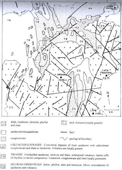
Figure 2: Slightly simplified map of solid rock geology in the study area (after Geological Survey of Malaysia. 1985).
Data processing and image products
Following a number of processing techniques (Jensen, 1986 and Mather, 1987), the contrast of six bands data were digitally enhanced. The images of all bands were compared in terms of contrast and definition of geological features (lineaments). As a result of visual evaluation, Landsat TM band-4 data which record the information at the wave-length between 0.75 to 0.90 mm were selected for this study, since it shows good contrast and display geological lineaments compared to the other bands.
In order to enhance the structural geological information (lineament) further, filtering techniques were applied to this band-4 Landsat TM data. The result shows that the a number of filters of the following values produced very good images enhancing the lineaments of the area. The filter values are as follows.
- Non-directional filter (Laplacian convolution filter)
0 -1 0
1 5 -1
0 -1 0
- Directional filter
1 0 1 -1 -2 -1 2 0 2 0 0 0 1 0 1 1 2 1 (north-south) (east-west) 2 -1 0 0 -1 -2 1 0 1 1 0 -1 0 1 2 2 1 0 (northeast-southwest) (northwest-southeast)
- Image of Band-4 which contrast is digitally enhanced
- Image of band-4 which is filtered by Laplacian convolution filter.
- Four images of band-4, each one is filtered by directional filer N-S, E-W, NE-SW and NW-SE respectively.
Some of the lineaments are only seen in a certain directional filtered images. This phenomena occur possibly because of the artifacts produce by the processing techniques that were applied in the images. To avoid the mistaken of considering the artifacts as the lineament in the interpretation, the following methods are followed.
In the study area, there are more than 300 lineaments (length of each one is more than 1 km) are traced with the total length is greater than 1400 km. However, only lineaments with length greater than 1400km. However, only lineaments with length greater than 2 km are shown in the map (Figure 3) since they may represent geological faults of the area. The lineaments furthermore are analysed in terms of their trend and position compared to the faults that previously mapped.
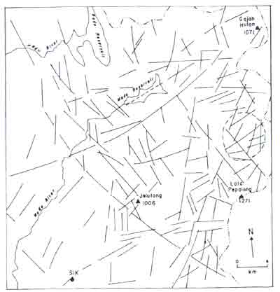
Figure 3: Lineament (longer that 2 km) and circular feature map of the study area derived from the Landsat TM images. See Figure 1 for comparison with the mapped fault of the area.
The lineaments traced show a quite similar pattern compare to the published data (faults) of the area. This indicate that, based on trend, the main features of fault pattern are enhance din the lineament map. However, in terms of total number and length, the traceable lineaments are much more greater than already mapped fault. The lineaments greater than 2 km long show very similar pattern with the faults shown on the published map of the area (Figure 2, 3 and Figure 4). This indicate that the traceable lineaments are very much related to these faults as proposed by Tjia (1971 and Ibrahim (1984) the lineament which is greater than 5 km long could be interpret to represent fault since it is too big to represent fracture or joint without any displacement took place along its plane. To prove such interpretation in the field is quite difficult in the tropical area because of rock outcrop is now always available due to extensive weathering.
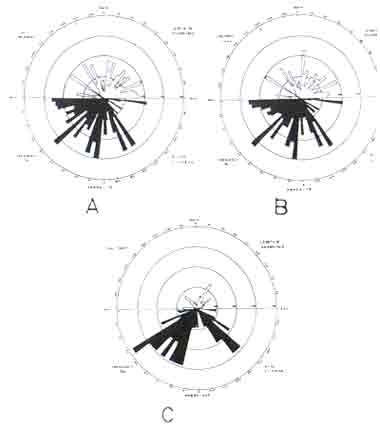
Figure 1: Rose diagrams of the lineaments (A and B) and mapped faults (C) calculated by both length as well as number of observation on the TM dara and geologic map respectively.
In terms of number and length, the traceable lineaments are 6.5 and 3.5 times greater than the faults mapped respectively. Since most of the faults and lineaments are overlapped in terms of their position (62% or 36 out of 58 faults), therefore most of the previously mapped faults should be mapped longer (Figure 5). Some of the major lineament are not coincide with mapped fault and are interpretated to represent faults which are not yet recognized and mapped before (Figure 5). However, there are lineaments (most of them are shorter than 2 km), which are not coincide with the fault and they are possible represent major joint of the area and not fault.
Other than the lineaments, the processing images are also showing circular features (Figure 5), but the geological meaning of these feature are not yet been interpreted. Lineaments density of several localities are higher than the surrounding, but is not very well correlated to the lithology of the area. However, these two features, circular features and high lineaments density might have some correlation with the area of high potential to find the economic mineral. It was proven in other area that the area of higher points of fracture or lineament intersections usually become a good target for economic mineral exploration (Riley, 1959 and Sabin, 1987). The relationship between the mineralized area and the fracture pattern and circular features by using the satellite data were reported before (Halbouty, 1976; Offield et. al., 1977; Ahmad, 1983 and Nicolais, 1974 and quoted by Sabin, 1987).
Conclusion
From the earlier interpretation and discussion, some conclusion could be drawn as follows:
- Remote sensing techniques could be used successfully to extract the structural geological information (lineaments) generally from any area in Malaysia and specifically from this area.
- Two images (contrast enhanced TM band-4 and Laplacian convolution filtered and directional filtered band-4) are the best to enhance the structural information (lineaments) of the area.
- The interpretated lineaments are closely correlated to the faults shown published map of the area and this indicate that the digitally processed remote sensing data could confirm most of the previously mapped fault.
- A number of major lineaments which are not coincide with the previously mapped fault may represent fault zone which are recognized before.
- There are region with circular features and of high lineament density probably related to miniralization area and need to be study in more detail.
- The result of this type of study might be useful to help further detailed geological mapping.
- If other remote sensing data such as SPOT or RADAR of the area are available which could display better texture and other surface morphology, possible better and more detail result could be presented then, the potential of using remote sensing techniques in such study in Malaysia will be higher.
The authors like to thank En Ibrahim Dom and En Abdul Ghani Idris for their help in drawing the maps and preparing the photographs. Special thank is due to Universiti Kebangsaan Malaysia for financial support through Research Grant (UKM 17/91) for this study.
References
- Ahmad, F., 1983. Relationships of mineral deposits and lineament analysis of the Rea Sea region, northern Sudan. Advance Space Research, 3: 71-79.
- Alamashoor, S. S. and Tijia, H. D., 1987. A prominent fault across the Malaysia-Thai boundary a preliminary report Warta Geologi (Newletter, Geol. Soc. Malaysia, 13: 35-37.
- Azikamil Napiah, Nguyen Ngoc Thach, Adnan Ismail & Nik Nasruddin Mahmood, 1996. Geological and mineral prospecting in Kuala Kelawang area using remote sensing and GIS techniques. Proceedings of the First Malaysian Remote Sensing Society Conference on Remote Sensing and GIS. K. Lumpur 25-27 November 1996, 11-118.
- Blodget, H. W. and Brown, G. F., 1982. Geological mapping by use of computer-enhanced imagery in western Saudi Arabia. U. S. Geological Survey Professional Paper 1153 (Washington D. C. U. S. Printing Office). 10p.
- Burton, C. K., 1973. Mesozoic. In Geology of the Malay Peninsula, edited by D. J. Gobbert and C. S. Hutchison (New York John Wiley): 97-141.
- Condid, C. D. and Chavez, P. S., 1979. Basic concepts of computerized digital image processing for geologists. U. S. Geological Survey Bulletin 1462. 16p.
- Foo, K. Y. 1976. Interpretation of Landsat-1 imagery of the Third East Asia IDOE Transect across Malaysia Malaysian Geological Survey Annual Report 1976: 183-192
- Geological Survey of Malaysia (GSM) 1985. Geological Map of Peninsular Malsysia, 8th edition, scale 1:500,000
- Halbouty, M. T., 1976. Application of Landsat imagery to petroleum and mineral exploration American Association Petroleum Geologists Bulletin, 60. 745-793.
- Hobbs, W. H., 1904. Lineaments of the Atlantic border region Geological Society American Bulletin, 15: 483-506.
- Hutchison, C. S., 1973. Metamorphism In Geology of the Malay Peninsula. Edited by D. J. Gobbert and C. S. Hutchison (New York: John Wiley) 253-303.
- Ibrahim Abdullah, 1984. Laneamen kepulaun Langkawi implikasinya terhadap geologi struktur Sains Malaysiana, 13. 45-62.
- Jensen, J. R., 1986 Introductory digital image processing- a remote sensing perspective ((Englewood Cliffs, New Jersey Prentice Hall), 379p
- Juhari M. A., 1990. Tafsiran geology imeg satelit: kajian awal menggunakan data dari Malaysia (Geological interpretation of satellite images: preliminary study using Malaysian data). Technical Report FSFG, UKG, Vol. 4, 1990: 48-75.
- ______ 1991 Digital processing of satellite images for geological applications Malaysian examples. In abstract Volume, Seventh Regional Conferences of Geology Mineral and Energy Resources of Southeast Asia (GEOSEA VII), Bangkok, Thailand 5-8 Nov. 1991: 37-38.
- ________1996. Geological applications potential of satellite multispectral scanner satellite data in Malaysia: a Kedah-Perak case study BORNEO SCIENCE , 2. 1-19.
- Lai, K. H., 1990. The geological interpretation of a SAR image of the Upper Segama Valley, Malaysia. Asian-Pacific Remote Sensing Journal, 2: 43-45.
- Mather, P. M., 1987: Computer processing of remotely-sensed images-an introduction (New York john Wiley & Sons)<352 p.
- Noor Bakri Endut, 1993. Pemetaan lineamen (struktur) geologi kawasan Penjom, Pahang dengan menggunakan teknik penderiaan jaun. Dalam Buku Program dan Abstrak Seminar Penggunaan Data Penderiaan Jauh Dalam Sains Bumi di Kawasan Tropika Universiti Kebangsaan Malaysia, Bangi, 14-15 Disember 1993: p. 30
- Nooraini Surip. Azlikamil Napiah, Jasmi Talib and Ku Mohd. Noh Ku Ramli, 1996 Geological mapping of north east Selangor area using remoe sensing techniques Proceedings of the First Malaysian Remote Sensing Society Conference on Remote Sensing and GIS. K. Lumpur 25-27 November 1996: P1-P16.
- Offield , T. W., Abbort, E. A., Gillespie, A. R. and Loguercio, S. O. 1977. Structural mapping n enhanced Landsat images of southern Brazil tectonic control of mineralization and speculations on metallogeny. Geophysics, 42. 482-500.
- O'leary, D. W. Friedman, J. D. nd Pohn, H. A., 1976. Lineament, linear lineation some proposed new standards for old terms. Geological Society America Bulletin, 87. 1463-1469.
- Raj, J. K., 1982. A reappraisal of the Bok Bak fault zone Warta Geologi (Newsletter, Geol. Soc. Malaysia), 8: 35-41.
- Riley, C. H., 1959. Our mineral resources (New York john Wiley & Sons), 338p.
- Rothery, D. A., 1985. Interactive processing of satellite images for geological interpretation - a case study. Geologial Magazine, 122. 57-63.
- Rowan, L. C., Wetlaufer, A. F., Goetz, A. F., Billingsley, F. C. and Stewart, J., 1974. Discrimination of rock types and detection of hydrothermally altered areas in south-central Nevada by the used of computer-enhanced ERTS images. U. S. Geological Survey Professional Paper 833, 35p.
- Sabin, F. F. Jr., 1987. Remote sensing-principles and interpretation second edition (New York: W. H. Freeman and Company), 449p.
- Siegal, B. S. and Abrams, M. J., 1976. Geological mapping using Landsat data Photogrammetric Engineering and Remote Sensing, 42: 325-337.
- Sudrajat, A., 1978. Geology of southwestern Sabah on Landsat images. Sains Malaysiana, 7. 223-234.
- Tija, H. D., 1971. Lineament pattern on Penang island West Malaysia. J. Trop. Georg. 32. 56-61.