| GISdevelopment.net ---> AARS ---> ACRS 1997 ---> Forestry |
Study on Forest Change
Detection in Eastern Forest by Remote Sensing Technique
Thanomsri Rangsikanbhum*,
Pongsak Polsena**, Chaowalit Silapathong*, Dararat Disbunchong*
* National Research Council of Thailand
196 Phahonyothin Rd., chatuckak, Bangkok 10900
** Department of Royal Forestry
Phahonyothin Rd., Chatuckak, Bangkok 10900
Abstract * National Research Council of Thailand
196 Phahonyothin Rd., chatuckak, Bangkok 10900
** Department of Royal Forestry
Phahonyothin Rd., Chatuckak, Bangkok 10900
The project was funded by the NRCT remote sensing research fund. The objectives of the study were to use satellite data to study forest changes during 1982-1993, and to produce land use map of forest encroachment area and its vicinities. The target area covered the Eastern Forest and its surroundings including Khao Ang Rue Nai Wildife Sancturary, Khao Soi Dow Wildlife Sanctuary, Khao Khitchakoot national Park, and Khao Chamao-Khao Wong National park with a total area of 9,584.58 km2. The study was conducted by using landsat TM bands 3,5 and 4 images acquired in 1993, 1988 and the map of 1982 existing forest, by the method of visual interpretation and Geographic Information System (GIS). The results showed that during the period of 1982-1993 forest was decreased depletion rate during 1982-1988 was as high as 101.12 km2 per year. While that of 1988-1993 was 30.86 km2 per year. Land use map of forest encroachemtn area and its vicinities was also produced with a total of 13 categories namely: evergreen forest, mixed deciduous forest, dry dipterocarp forest, forest plantation, deteriorated forest, paddy field, rubber plantation, field crops mixed orchard, urban area, water resource, road, and other.
Introduction
Eastern Forest is the only forest area remaining in eastern region of Thailand. The Forest covers some parts of 5 provinces namely : Chacherngasao, Sakaew, Cholburi, Rayong, and Chanthaburi. Another name of the Forest is therefore "Contiguous Forest Connecting 5 Eastern Provinces". Eastern forest area was decreased rapidly, especially during the last decade. Forest encroachment areas were found both along the Forest border and among dense forest. Eastern Forest management plan was therefore necessary to be set up to protect such the important forest. Information of this area were also needed including: existing forest area and map, forest change, and land use map of the surrounding areas. To derive such information, remote sensing and geographic information system were applied. The objectives of the study were : to assess and map existing forest area, to detect forest changes during 1982-1993, and to produce land use map by using remote sensing and GIS techniques.
Study area
The area under study covers the whole area of Eastern Forest and its vicinities including Khao Ang Rui Nai Wildlife Sancturary, Khao Soi Dow Wildlife Sanctuary, Khao Khitchakoot national Park, and Khao Chamao-Khao Wong national park with a total area of approximately, 9,584.58 km2. The area is located between 12°17'-13o30'N and 101°40'-102°6' E. Te topography of the area comprises mountain, undulating terrain and low terrace. Various types of forest were found mostly in mountain our topography including evergreen forest, mixed deciduous forest, and dry dipterocarop forest. Forest encroachment area was mainly used for agricultural purposes such as field crops, rubber, and mixed orchard. Paddy was scarcely found due to unsuitable topography.
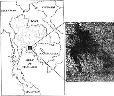
Figure 1 Study Area
Data and Equipments
- Existing forest of 1992 at scale of 1:2550, 000 produced by Department of Royal Forestry.
- Landsat Tm color composite image, bands 3 5 4 (BFR) at a scale of 1:50,000 acquired on February 20, 1988.
- Landsat TM color composite image, bands 3 5 4 (BGR) at a scale of 1:250,000, acquired on February 1, 1993.
- Land use map at a scale of 1:100,000 produced by Department of Land Development.
- SPAN-Geographic Information System.
- Global Positioning System.
- Visual Interpretation of 1988 Landsat TM image was performed to extract forest existing area from other land use categories.
- Visual interpretation of 1993 Landsat TM image was performed, with the supplementary information from ground truth observation, to extract forest existing area, to identified forest type, and to define land use categoriesin forest encroachment area.
- Digitization of forest existing area of 1982 Zderived from forest map), 1988 and 1993 into the SPAN GIS to assess forest area changes during each period.
Results obtained from the study can be described briefly:
- Existing forest areas of 1982, 1988 and 1993 were 3,562.58 km2, 2,955.89 km2 and 2,801.57 km2 respectively.
- Forest encroachment area during 1982-1988 was 606.69 km2 or forest depletion rate was 101.12 km2/year.
- Forest encroachment area during 1988-1993 was 154.32 km2 or forest depletion rate was 30.86 km2/year.
- A total forest encroachment area during 1982-1993
was761.01km2 or forest depletion rate was 68.18
km2/year.
Forest encroachment map as appears in Figure 2.
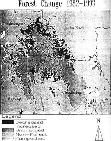
Figure 2 Map showing forest changes during 1982-1993
- Land use map obtained from 1993 Landsat image interpretation comprises 13 categories namely: evergreen forest, mixed deciduous forest, dipterocarp forest, forest plantation, deteriorated forest, paddy field, rubber plantation, field crops, mixed orchard, urban area, water body, road, and others.
- Pongsak Polsena, 1994, Eastern Forest, paper presented in the seminar on Eastern Forest, Chacherngsao, Thailand.
- Thongchai Charuppat, 1994, Using Landsat 5-TM Imagery For Monitroing the Changes of Forest Area in Thailand, Departemnt of Royal Forestry, Bangkok, Thailand.
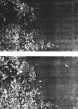
Figure 3 Forest changes appear in Landsat image of 1998 (upper) and 1993 (lower)