| GISdevelopment.net ---> AARS ---> ACRS 1997 ---> Education/Training |
Remote Sensing Data Servers:
An Enabling Technology for the development of Applications
Yves Henaaf, Jean-Francois
Gallet, Gilles Richard, Michel Mariton
Matra Systemes & Information
6 Rue Dewoitine, 78142 Velizy-Villacoublay, France
1- Introduction Matra Systemes & Information
6 Rue Dewoitine, 78142 Velizy-Villacoublay, France
The early use of space-based earth observation was dominated by strategic concerns with limited operational applications, except for the notably successful use of spy satellite as a means to protect national interest. This period however allowed a maturation of the underlying technologies and a reduction of their cost.
The transition towards the development of applications with a larger user baadse is now feasible, and further facilitated by concurrent evolution on the general Information Technology scene (Windows NT, Java…).
This paper presents a key technological component, the Remote Sensing Data Server, from both technical and application points of view.
2-Application Needs
Satellite Remote Sensing data has proved that it can be extremely useful gathering many types of information, but is still strongly under utilized. Some experts have estimated that 85-90 Gigabytes of data produced has never been used for operational purposes.
Apart from limitations related to the earth observation space segment e.g. high investment and fixed cost, limited number of satellites and consequently low revisit cycles, there are technical obstacles to the wider use of Remote Sensing data associated with the ground segment (i.e. the chain of systems for data acquisition, transport, archiving, processing and delivery):
- Existing Earth Observation ground segments make only limited usse of on-line user access to data processing systems and advanced communication networks for interactive product retrieval.
- Earth Observation Products, e.g. satellite images, are mostly based on standardized geographical coverage's and may require substantial processing by the user. Many end users instead need smaller areas of derived information.
- Non-space data and in particular Geographical Information Systems data, important for many applications, are only starting to be integrated with satellite image data.
3-Users'demand: Two Examples
3.1 - Impact Studies
Clean, non-polluting electricity habitat s better environmental credentials than many types of power, but its distribution is a live issue in more ways than one. In most Western countries, National distribution networks were established before the rise of the environmental lobby, but news high-voltage lines still have to be laid, ands old ones require renewal or relocation. Efforts are made to bury lower voltage electric lines, the caloric diffusion of high voltage lines is substantial, so these remain aerial for reasons of health and safety as much as cost.
Above all, electric power transportation must be secure, but planners must also be mindful of the visual impact of electricity lines. A typical problem is finding a way to increase energy transportation on an exiting line. Which is better - one large pylon or two small ones? How can we present a model which is comprehensive without being confusing? And most importantly, how can we justify the decisions we make?
In close cooperation with Electricity development France, the French National power utility, we analyzed the basic requirements for a system, called EVELINE, that integrates computer graphics technology with digital mapping, and can be used to model, simulate and view the impact of electricity lines of the environment.
Most projects will begin with an impact study, where a power supply company and local authority will assess the environmental implications of pylons and power lines. Determined by maps, orthophotos and other data, this will identify physical characteristics and other local constraints within which the project must operate. Each is given a weighting, and on this basis a decision made about the strip of terrain over which the supply line can be set up.
It is clear that Remote Sensing can contribute to the above problem, provided it is brought into the Impact Study domain by some enabling tools. Besides the electric power line example discussed above, similar requirements emerge for large freeway or dam projects, in fact any major construction project.
3.2 - Insurance Risk Management
For insurance companies, valuable information about their risk portfolio consists in:
- Information about the risk to be insured, in order to define the right and competitive premium level;
- When a sinister occurred, information about its impact, in order to define the reimbursement amount.
As an illustration, lets consider the cost of information related to damages declaration checking, for a typical insurance company operating in the agriculture area (see figure 1)
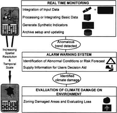
Figure 1: Typical damage declaration checking process
- When a climatic disaster occurs (such as drought or flood), farmers submit declarations starting the impact on the crop, to be reimbursed;
- The farmers' declarations are controlled in-situ, with the help of expert agronomist, who individually check each declaration. In terms of crop type and area damaged;
- in case of disagreement, the declaration may be reassessed by an additional expertise in the field.
An information service is therefore requirement to provide insurance companies and public bodies in charge of agriculture damages with inputs for their decision making processes. The contribution of Remote Sensing can be analyzed at three levels:
- First level : route information, through monitoring of climatic conditions; this provides an overall assessment of the situation, and enables to trigger the second level, when anomalous climatic trend is detected. This information is mainly derived from low resolution Earth Observation data, such as NOAA/AVHRR data, and meteorological data.
- Second level : when abnormal conditions are detected over a specific area, a more refined information is elaborated, to help users assess more precisely the risks at stake.
- Third level : upon a catastrophic event, such as drought or flood, detailed information is derived from high resolution data, such SPOT, LANDSAT and ERS data, in order to provide the basis for damages declarations checking, without systematic field inspection.
4-Enabling Tools: The Remote Sensing Data Server
4-1- Objectives
A common requirement to the above discussed application domains is the Remote Sensing Data Server. Elaborating on the development of such a server with partners like the EU Joint Research Center, SPOT Image, ESA/ESRIN… the ISIS enabling tool can be proposed:
- User Defined Formats are pre-selected and limited in number to allow the delivery of the adequate format to the desktop.
- GIS Information is provided in support to satellite image data to to answer to applications requiring also geographical information.
- Accounting schemes are demonstrated which can take into consideration ythe actual amount of data retrieved, other application specific parameters, e.g. the use of a particular algorithm, and reflect resource consumption, e.g. processing time.
- Application Specific Service Interaction. The ISIS server interaction and users interfaces are tailored to the different applications, e.g. a sea-surface temperature processing in support to fishery in Ireland will display a corresponding map of the costal zone and use pre-selected algorithms and data sets from a priori identified suitable sensors.
- Intranets-internet/Euro-ISDN. ISIS demonstrates how both private and public data networks, can be used to improve delivery times. Data centers may be connected through Intranets, whereas users may make use of Internet/Euro-ISDN to connect to data centers.
- Internet technologies are the basis for the system. They provide development-facto standards and a large market of commercial products, providing interoperability and scalability. Millions of people are used to the look and feel of the World Wide Web services and the WWW will support the wide adoption of Java based user interfaces and functions.
- Transport Client Software Configuration allows the client software to be delivered to the user automatically through the internet so the inconvenience of additional software installation is avoided.
- Tool Kits for client interface creation and server functions implementation make it relatively easy for organizations to create new application oriented user interfaces and applications. The same technique will be applied to the server to introduce nesting site processing functions.
- Object Request Broker technology is the basis of the system architecture, allowing a modern, modular, object oriented design and the distribution of functions across networks. ISIS will use technologies based upon COBRA, the common objects request broker architecture standard.
Intelligent Data Selection and Compression [1,2] provides a set of techniques to select the information of interest, e.g. geographical area, and reduce the amount of data transmitted over networks. By extracting only the region of an Earth Observation product a user needs, processing it to only the information needed by the application, and subsequently compressing the data, the volume will be greatly reduced [3].
"Regions off Interest" definitions will allow the users to define arbitrary geographical areas independently of the coverage of the product that was acquired by the satellite.
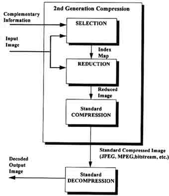
Figure 2: Intelligent Selection & compression
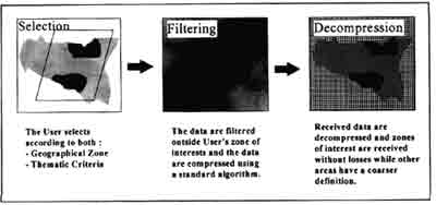
Figure 3: Example
References
- M. Carisohn, M. Paillou, M. Louys, F. Bonnarel, Evaluation of Codings of Space Images with respect to their Astronomical Semantics, Proc. $th Int. Workshop on Image Analysis and Synthesis, 1993
- H. LI, A. Lundmark, R. Forchheimer, Image Sequence Coding at Very Low Bitrates : a Review, IEEE Image Processing, precursors 1057-1149, 1994
- VD. Vaugan, T. Wilkinson, System Considerations for Multispectral Image Compression Designers, IEEE Signal Processing Magazine, precursors. 1053-1088, 1995.