| GISdevelopment.net ---> AARS ---> ACRS 1997 ---> Disasters |
(Remote Sensing Satellite Ground Station, Chinese Academy of Sciences)
Tel: (8610)6259679 Fax: 8610)62561215
E-mail: xyhe@nts.rsgs.ac.cn
In this paper, a model was developed to monitor and evaluate the forest pine caterpillar damage according to TM data and the forest resource database which were based on the conventional investigation. By image processing and database query, the multi-dimension forest resource information images, which were based on the working spots of forest management and TM data, had been acquired. Accordingly, the accurate foundation of the detection for the pine caterpillar damage sites was provided by analyzing these raster data with satellite images.
Background
Computer database is a whole set of related data with minimum redundancy. With the rapid development and popularization of computers, database technology has been applied in many fields for it can efficiently and effectively organize and process data, conveniently search for data and carry out statistical work. In the broad field of scientific research, database technology introduce how we have applied database technology in our remote sensing and evaluation of major forest insect pests. To be more specific, it deals with how we accurately decided on the pine caterpillar occurrence sites by integrating data from forest management and pest situation ground investigation with data from the remote sensing satellite, and how we have built databases for management, analysis and data processing with part of the results derived from the processing of remote sensing images.
The introduction will be made from the following perspectives:
Working environment and source of data
We chose, as our working areas, two forests, one in the northern Shanxi province and another in the southern Fujjan Province. The type of insect pest to work on was forest pine caterpillar plague which occurred most easily with maximum damaging effects. Both of the working areas have good forest management foundation in that they had carried out the second-class investigation on forest resources upon the requirement of the Ministry of Forestry and built forest resource databases on the basis of the investigation. The remote sensing data came from The TM of LANDSAT -5 during the 1988 to 1994. The working environment was the self-developed image-processing computer system and database system.
Converting the attributive data in the database into raster data fir for the processing of remote sensing images
The normal practice with remote sensing application research is to rapidly process, image pixel by pixel, data of multi-spectral bands and then extract the image information that is of interest, making use of the advantages of remote sensing data such as having stable sources, continuity and rich information. Its result is to operate on raster data. However, the forest investigation database is a collection of records which has forest management working units as identification keys.
Take as an example the database which resulted from the second-class investigation on the forest resources in the northern forest. The structure of its data is as follows:
| Attributes: | Forest spot No. | INT | 8 | Working Unit No. | INT | 8 |
| Tree variety | CHA | 8 | Tree age | INT | 8 | |
| Tree height | INT | 8 | Diameter | INT | 8 | |
| Canopy density | INT | 8 | Unit area | INT | 8 | |
| Soil type | CHA | 8 | Soil thickness | INT | 8 | |
| Scrub coverage | INT | 8 | Grass vegetation coverage | INT | 8 |
Data structure in the tree-felling history database:
| Attributes: | Forest spot No. | INT | 8 | Unit No. | INT | 8 |
| Way of felling | CHA | 8 | Operation time | INT | 8 | |
| PF forest variety | CHA | 8 | PF diameter | INT | 8 | |
| PF canopy density (Note: PF-Post-felling) |
INT | 8 | PF tree height | INT | 8 |
They reflect many types of information linked with forest management based on working units. The database from the second-class investigation on forest resources reflects the plants’ living environment and the state they are in. The tree -felling history database reflects the density of each felling and the change in tree varieties. Some of the attributes in the database play a decisive role in remote sensing application. For instance, we can still use a database with poor time effectiveness to work out the tree varieties in a forest zone and its canopy density with the help of TM images, which can serve as a priori knowledge for the classification of tree varieties and their living environment by means of image processing. The essential issue involved is how to specify their spatial positions on a raster image. To do this, we need to convert the values of each attribute in the database into images with plural elements in accordance with what is needed in image processing, so that the values can be conveniently and directly used in the applied processing of remote sensing. The detailed procedures involved are as follows:
- To enter into the computer the digitalized 1:50000 diagram of
boundary lines between working units and register it with the
30*30-meter resolution of TM data.
- To develop a raster file with forest spot numbers and working unit
numbers.
- Using the forest spot number and unit number as indexes, to inquire, image pixel by pixel, for the values of corresponding attributes, and develop images with special elements on the basis of working units.
- With respect to the selection of a classified sample training zone
corresponding with the TM image, we chose a small zone which fell in the
category of pine trees in the tree variety distribution diagram, has a
canopy density of varied degrees and trees of different ages. We then
worked out the accurate pine tree distribution for the selected zone by
means of image classification methods.
- For some individual places where there were rich grass vegetation
and scrubs and it was difficult to distinguish such coniferous trees as
pines and China firs, we used the tree variety distribution diagram to
set the boundary lines between different periods and the felling
operation diagrams developed over the previous years on the basis of the
felling history database to determine the causes for the obvious
reduction in the number of vegetation biomass or whether the reduction
was caused by pests of insects.
- We used variable information extracted from pine vegetation index
with different periods and the felling operation diagrams developed over
the previous years on the basis of the felling history database to
determine the causes for the obvious reduction in the number of
vegetation biomass or whether the reduction was caused by pests of
insects.
- We calculated the elevation of the working unit suffering pest of
insects, the degree and direction of its slope by means of investigation
diagram on ground insect pest situation and DTM images. We then
retrieved attributive values that were conductive to the multiplication
of pine caterpillars such as the pine diameters of individual working
units, their canopy density, soil, grass vegetation and scrubs, etc.,
and conducted calculations and statistical work. With the results thus
obtained, together with knowledge from entomologists, we built a pine
caterpillar situation monitoring medel in view of the features of the
pine caterpillar site, such as geographical environment, soil grass
vegetation, climate, population and so on.
- A diagram illustrating the number of pine trees in a working unit suffering pest attack and the density of caterpillars on per pine tree was figured out on the basis of the pest situation ground investigation database. We compared the diagram with the vegetation organism variation diagram so as to determine the quantitative relationship between the degree of organism reduction and the scales of insect plagues that occurred.
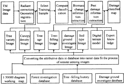
Figure 1: Component images derived
Thus, in addition to satellite remote sensing images, other subsidiary information is stored in the form of database files. When needed in the processing of images on the computer, the information can then be real-timely converted into raster images to participate in the processing. The multi-element information is in one-to-one correspondence with TM data in space and its is easy to carry out comprehensive analysis based on images pixels with the help of expert knowledge. In the meantime, it can help maintain the rapid retrieval of data from database and the easiness analysis.
Building a database for damage spots, and analyzing and managing the results of image processing
Results obtained by information extraction from the data of remote sensing satellites used to be expressed by images. For instance, the distribution of pine caterpillars damage was illustrated by spots of different sizes. The region where as insect pest occurred, no matter whether it has an area as large as several square kilometers or as small as several images pixels, the location of the plagued region and the distribution of the pests were clear to the eyes. However, that was not enough to meet the needs of forest management for we still lacked such information as the variation in the number of organism after the plague damage, the recovery of trees and the influence of the geographical and environmental factors on the insect plague. Moreover, the need to test and verify the monitoring models that wee built up made it also necessary to conduct further management on the comprehensive information of damage spots. Therefore, we built a database with information about insect plagues for management and analysis to meet the needs of forest management. To facilitate the inquiring and expansion of the database, we developed the smallest damage spot units, having the forest operation management area as a unit of forest spot and dividing forest units with boundaries between the working units. We also built records of the sequence numbers of the damage spots on the basis of the sequence of the damage spot units appearing on the image. In each record, the identification key, the forest spot and the working unit number were primary keys. The set of attributes included the frequency of plague occurrence, the plague scale, plague area and the number of background biomass, the number of biomass during the plague periods, the variation in the number of biomass, elevations , the degree of slopes and the slope directions, as illustrated in the following table:
| Damage Spot unit | Forest spot | Working Unit | Occurrence frequency | Damage level | Area (m2) | RVIB | RVIP | Elevation of slop | Degree of slope | Direction of slope |
| 71 | 27 | 6 | 2 | 1 | 16245 | 167 | 52 | 460 | 20 | 4 |
Among the items, the frequency of occurrence reflects the how the pests
that occurred in the same forest spot and the same working units are
community-like. The number of background biomass refers to the ratio
vegetation index (RVIB) prior to the pest. The number of biomass during
the pest period is RVIM. The variation in the number caused by the loss of
pine needle leaves eaten bypine caterpillars. RVIB, RVIM and RVIP are the
statistical average values for the smallest damage spot unit. Likewise,
elevation and the degree of slope are expressed by the average values in a
damage spot unit. For the direction of slope, due north is zero degree.
The three-hundred-sixty degrees which were turned counterclockwise were
divided statistics, we had the slope direction in which most image pixels
were located as the major slope direction and calculated its value. The
stand information linked with the information of damage inquired function
of the database. Take the No. 71 damage spot unit as an example, the
canopy density of the forest was 0.7, its site type being Type Two and the
average tree age 22. Similarly, the number of insect plagues that had
occurred in the damage spot in history and the plague scales the pests
could be obtained from the ground pest situation database. The attributive
data in the database came from the results of remote image processing,
which were entered rapidly and accurately into the database all at once.
Various types of subsidiary images were involved as well. The structure of
the database had minimum redundancy with different items having clear and
graphic relationship. All these guaranteed that the data in the database
could be retrieved with great convenience. Thus, the database served as a
very handy means through which forest managers and entomologists could
analyze and evaluate the factors causing the occurrence and development of
insect plagues and the plague scales.
Verifying experts
knowledge about the conditions for the occurrence of insect plagues with
the help of the inquired and statistical functions of
database
Entomologists have pointed out that the occurrence of
rampant insect plagues are closely related to the biological communities,
topography and geographical environments. For instance, most insect
plagues occur on the sunlit side of a slope since this side often enjoys
warm weather and lingering wind. In other words, the climate in the small
location is conducive to the multiplication of pine caterpillars.
Moreover, with the grass vegetation and scrubs being him and rare, pine
caterpillars have relatively les varieties and small number of natural
enemies. The canopy density of the forest is between 0.5 and 0.7 in the
meantime, all the other factors such as the elevation of the damaged area,
the degree to which pine tree and broadleaf trees and mixed, the soil and
forest managerial measures play a part in the occurrence and development
of the insect plagues. With this knowledge in mind, we carried out
comprehensive statistical work on 297 small damage spots and found that
the situation in most of the damage spot conformed to the knowledge raised
by the experts.
In addition, among the data obtained from an
investigation on the ground insect pests in the southern experimental area
in 1992 showed as following;
| Density of Caterpillars (number/per pine) | Investigate Sites | Number of Sunlit slope | % | Degree of slope <30 | % |
| >0 | 53 | 41 | 77.36 | 40 | 75.48 |
| >50 | 36 | 31 | 86.11 | 26 | 72.22 |
| >80 | 28 | 24 | 85.71 | 23 | 82.14 |
We learned that the region where relatively serious damages occurred, the slopes were more gentle and sunlit slopes accounted for 70 percent of all the slopes where plagues occurred, which also agreed with the experts’ viewpoints.
Discussions
Supported by multi-disciplines of learning such as computer image processing technology, geographical information technology, research on remote sensing application has developed rapidly. As part of the research, the advantage of database such as having small redundancy, and being easily accessed are being tapped to an increasing degree. On one hand, we can integrate the attributive data in the analysis and judgment of image pixels in the processing of remote sensing images; on the other hand, we can update the database or build new databases with results obtained from the processing of remote sensing data to facilitate management. Hence, the explorations in this field can be both new and significant. As a matter of fact, with the uplifting of the general management level in China, we believe that there will be more and more attributive database information accumulated, which serve as rich information sources for the application of remote sensing technology. Meanwhile, with the remote sensing application technology being well integrated with other disciplines of learning, it will better serve the information management work in various fields.
Reference
- Hou Taoqian, et al. 1993. Research on the Variety Distribution of
Pine Caterpillars in the China and the progress in the Research on the
Remote Sensing Monitoring and Evaluation of Grave Natural Disasters.
China Science and Technology Publishing House.
- Xue Xianqing. 1993. The Influence of the Climate in a Larger Region on the Occurrence of Masson Pine Caterpillar Pests. Nanjing Forest Industry Journal, 3: -53.