| GISdevelopment.net ---> AARS ---> ACRS 1997 ---> Disasters |
Remotely Sensed Geohazards
for Assessing Alternative Corridors
Jian-King
Liu
Research Scientist and Head of
Mineral Resources Department
Energy and Resources Laboratories, ITRI
Hsin-Chu 310, THAIWAN
Tel: +886-3-591-6352; Fax: +886-3-582-0017
E-mail: f660124@erlb.erl.itri.org.tw
Research Scientist and Head of
Mineral Resources Department
Energy and Resources Laboratories, ITRI
Hsin-Chu 310, THAIWAN
Tel: +886-3-591-6352; Fax: +886-3-582-0017
E-mail: f660124@erlb.erl.itri.org.tw
Abstract
The most difficult part of constructing a sound national highway system in Thailand is to manage the difficulties of crossing the mountainous terrain, where are geologically hazard-prone areas and there are very rare existing geological information. Therefore remotely- sensed data have been employed very extensively since 1990 to give information on geo-hazard. It was also found that by using air-photos taken 40 years ago, abandoned river courses and ancient ponds in the level and hilly terrine, where now are covered by recent deposits and highly cultivated, can be readily identified to give indications of geological sensitive areas. It is, therefore, concluded that when conventional aerial photographs are employed together with satellite images, the best benefit by using remote sensing techniques can be gained. In mountainous terrain, images can be used to locate potential Landslides; in hilly or level terrain, images can be used it identify weak and sensitive geological units. This information is valuable for assessing alternative highway corridors.
Introduction
More than two thirds of Taiwan Island are covered by rugged terrain. The small portion of the relative level areas is over populated, where most of towns are with a density of more than 2000 people per square kilometer. Having a sound highway system is critical to improve the quality of life. The most difficult part of it is to cross the mountainous terrain, where are geologically hazard-prone areas and there are very rare existing geological information.
As imposed by time constraints, insufficiency of geological information, and the low accessibility of the mountainous terrain, the benefits to adopt remote sensing techniques are obvious. Therefore, remotely sensed data have been employed very extensively since 1990 to give information on geo-hazard. It was also found that by using air-photos taken 40 years ago, abandoned river courses and ancient ponds in the level and hilly terrain, where now are covered by recent deposits and highly cultivated, can be readily identified to give indications of geological sensitive areas. As the experience shows, conventional aerial photographs are employed together with satellite images in the cases discussed in this paper.
Physiographic Background of Taiwan
It is shown in Figure 1 that more than two thirds of Taiwan Island are covered by rugged terrain. The small portion of the relative level areas (less than 30%) are over populated, where most of towns are with a density of more than 2000 people per square kilometer. Due to the rapid economic growth in recent years, an urgent need to have a sound highway system in deemed critical to improve the quality of life. However, there are various types of geological hazards distributed all over the Island. To have an approach for quick assessment for corridor selection in the early stage of highway engineering would contribute to the society significantly. Methodology was developed in the past few year, by adopting all types of airborne and space-borne images in various type or stage of highway planning, as will be discussed in the following paragraphs (Liu, 1983, 1984, 1986, 1987)
Selected Cases Since 1990
As shown in Figure 2, a national highway network has been initiated in Taiwan and various types of remotely-sensed data has been applied for various types of analysis in various engineering stages (Table 1).
A Typical Approach
The approach adopted for the creation of a set of geological hazard maps in the stage of corridor selection in the preliminary planning phase of Southern-cross National Highway (Number 2 in Figure 2) is given here for an example. There are three steps in this project, including
- the creation of criteria and guidelines as the philosophy for the
decision making by using results from remotely-sensed data;
- establishing procedures for analyzing images and other ancillary
information; and
- fusion of all the resultant maps from step2.
- the geological information required in feasibility study stage, as a
contrast to what can be extracted from remote -sensed data;
- adequacy of existing and available information for ancillary
information;
- reliability and repeatability of evaluation, meaning that an
objective approach is preferable;
- available means; and
- time constraint.
- information to be extracted from remotely-sensed data is
concentrated on major geological constraints;
- themes by remote sensing techniques are : drainage system,
lineaments, landslides, major geological structure, lithology, and
geothermal sites;
- applying GIS technology for compiling and integrating various
sources of information;
- a well-defined criteria with a scale of 5 classes for intra-factors and expert-rated weighing table for inter-factors.
| Name of Plan(Study Area Size) | Time ConstraintOf Image Study | Type of image Data Used | Items Processed |
| Case 1. 2nd Freeway(Taipei-Iiam)(260Km2) |
5 months | 1. 1974-1975 Airphotos 2. 1990 SPOT image 3. 1990 LANDSAT image 4. 1982 SLAR image |
1. drainage system 2. lineaments 3. landslides 4. major structures 5. image tone analysis |
| Case
2. Southern-crossNational Highway(360Km2) |
10 months | 1. 1974-1976 Airphotos 2. 1990 SPOT image 3. 1990 LANDSAT image 4. 1982 SLAR image |
1. drainage system 2. lineaments 3. landslides 4. major structures 5. lithology 6. geothermal sites 7. mineral resources 8. DTM 9. GIS ANALYSIS |
| Case 3. 2nd Fw Suao Extn.Section (360Km2) |
4 months | 1.1974-1975 Airphotos 2.1993 Airphotos |
1.geological
hazards 2.landuse change |
| Case 4. 3rd Fw FongyenSection (36Km2) |
1 months | 1. 1948-1948 Airphotos 2. 1974-1975 Airphotos 3. 1993 LANDSAT image |
1.tracing 2 faults |
| Case 5. 3rd Fw Nanto Sec.(72Km2) |
2 months | 1. 1948-1948 Airphotos 2. 1974-1975 Airphotos 3. 1993 LANDSAT image |
1. geological
hazards 2. major structure |
| Case 6. Eastern NationalHighway(3500Km2) |
6 months | 1. 1991-1992 Airphotos 2. 1988 image 3. 1988 LANDSAT image 4. 1982 SLAR image |
1. lithology+weak
rocks 2. lineaments 3. landslides 4. major structure 5. geothermal sites |
| Alternatives Themes | 1 | 2 | 3 | 4 | 5 | 6A | 6 | 7 | 8 |
| 1.Landslies | 58.68 | 83.24 | 82.74 | 74.559 | 81.00 | 58.90 | 886.80 | 83.37 | 77.41 |
| 2. Streams | 77.76 | 62.62 | 56.14 | 52.31 | 52.59 | 48.03 | 67.43 | 91.97 | 93.63 |
| 3.Sturcture | 9.70 | 7.65 | 8.30 | 6.53 | 5.00 | 5.15 | 6.30 | 5.0 | 7.15 |
| 4.Lithology | 9.70 | 101.85 | 85.52 | 96.32 | 98.55 | 117.84 | 97.43 | 120.05 | 141.61 |
| 5.Lineaments | 136.94 | 26.0 | 27.00 | 23.0 | 17.0 | 19.0 | 10.0 | 24.0 | 16.0 |
| 6.Geothermal | 18.4 | 0.37 | 0.37 | 3.90 | 3.90 | 3.9 | 0.59 | 1.40 | 1.4 |
| Total Score | 1.25 | 281.74 | 260.07 | 256.65 | 258.04 | 252.82 | 268.55 | 325.61 | 337.2 |
| Grade | NG | G | B | B | B | B | B | NG | NG |
| Order | 7 | 6 | 4 | 2 | 3 | 5 | 5 | 8 | 9 |
| N.B. Better: Total score<270; Good: 270<T. Score<300; No Good T. Score>300 | |||||||||
| Alternatives Considerations |
3 | 6A | 6 |
| 1. Engineering Order | 3 | 1 | 2 |
| 2. Geological Order | 2 | 1 | 3 |
| 3. Environmental Order | 3 | 2 | 1 |
| Total Order | 8 | 4 | 6 |
| Re- Order | 3 | 1 | 2 |
Conclusion
Various types of remotely-sensed data can be efficiently and effectively applied to obtain geological information for the low accessibility areas of Taiwan. As a result of our study in the early stage of national highway route selection, the usefulness and the necessities to adopting remote sensing has been recognized by the government authorities. It is therefore a chapter dedicated to remote sensing geology is included in the Guidelines on Geo-technical Engineering Survey issued by Taiwan Area Expressway Engineering Bureau, Ministry of Transportation and Communication. Based on the guidelines, remote sensed geohazards become a required tool for the study on surface geology of highway project area.
It was also found that by using air-photos taken 40 years ago, abandoned river courses and ancient ponds in the plain and hilly terrain, where now are covered by recent deposits and highly cultivated, can be readily identified to give indications of geological sensitive areas. It is, therefore, concluded that when conventional aerial photographs are employed together with satellite images, the best benefit by using remote sensing techniques can be gained. In mountainous terrain, images can be used to locate potential landslides; in hilly or plain terrain, images can be used to identify weak and sensitive geological units. This information is valuable for assessing alternative highway corridors.
Reference
- Liu Jin-King and Tseng Wen-Tse (1983) An evaluation of various
remote sensing systems as applied to engineering geological
invetigation. Mining and Metallurgy, vol.27, no.3,p.120-131. CSMME.
- Liu Jin-King (1994) Aerial photographs for engineering geology-some
examples of landslide investigation. Remote sensing, No.4, p.97-123.
Published by Remote Sensing Development and Promotion Committee,
Ministry of Economic Affairs, ROC.
- Liu Jin-King (1986) Remote sensing for landslide identification and
prediction. Mining Technology, vol.24,no.1, p.50-64.ERL,ITRI.
- Liu Jin-King(1987) Automation of landslide extraction from
remotely-sensed data. Remote Sensing, No. 8, p.60-90. Published by
Remote Sensing Development and Promotion Committee, Agricultural
Council, Executive Yen, ROC.
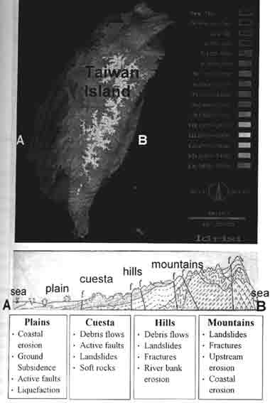
Figure 1 Various geohazard Types in various Terrain.
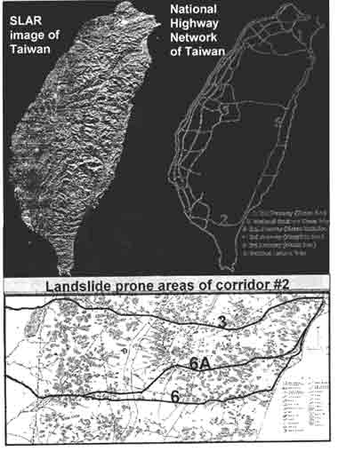
Figure 2 SLAR image of Taiwan and the National Highway
Network that adopt Remotely-sensed Geohazard Study