| GISdevelopment.net ---> AARS ---> ACRS 1997 ---> Disasters |
Slope Instability and Hazard
Zonation Mapping Using Remote Sensing and GIS Techniques in the Area of
Cameron Highlands, Malaysia
Jasmi Ab.
Talib
Malaysian Centre for Remote Sensing (MACRES)
Ministry of Science, Technology and the Environment
Lot CB 100, 5th Floor, City Square Centre,
Jalan Tun Razak, 50400 Kuala Lumpur, Malaysia
Tel: (6)-03-2645640 Fax: (6)-03-2645650
E-mail: planning@macres.gov.my
AbstractMalaysian Centre for Remote Sensing (MACRES)
Ministry of Science, Technology and the Environment
Lot CB 100, 5th Floor, City Square Centre,
Jalan Tun Razak, 50400 Kuala Lumpur, Malaysia
Tel: (6)-03-2645640 Fax: (6)-03-2645650
E-mail: planning@macres.gov.my
The aim of this study is to utilize the remotely sensed data and GIS techniques for slope instability assessment and prediction in the Cameron Highlands, area, in the Northwest of Pahang State, peninsular Malaysia. Slope instability can be considered as one of the most actual issues affecting this area, lately. With the availability of different types and various scale of remotely sensed data, several parameter maps can be generated, emphasizing the mass movements distribution map. GIS, on the other hand, can assist in terms of speeding up processing and moreover in the hazard zonation and prediction assessment.
The result of slope instability study by using the Information Value Method, has given the indication of the most relevant causative factors influencing the mass movements occurrences in this study area. The construction of the roads at steep slopes can be considered as the most important causative factor, as is borne out by its high information value especially for the main and secondary roads. Another factor which has high value is landuse besides the slope steepness and distance from fitht, sixth and higher order river, even though classified slope and distances are of lesser influence to the mass movements occurrences. By summation of causative factor maps in that method, resulted in the delineation of the mass movement hazard zonation. Hence with the classified information from the infrastructure and landuse units, the risk to the area can be assessed. The very high risk area cover 164,600 m2, mostly emphasizing several main road slopes and part of the market gardening area in Bertam Valley and some sloping areas in Tanah Rata and surroundings.
Introduction
Landslides are one of the normal landscape building processes in mountainours areas. They become a problem when they interfere with human activity in which their disasters normally result in damage to properties and loss of life. Although most landslides are small and individually cause few fatalities, the cumulative losses worldwide account for around 25 percent of annual deaths from natural hazards (Hansens, 1994).
In tropical mountainous areas, slope failures either initiated by natural processes or by human activities are a major cause of natural disasters. Although a small percentage of the individual slope failures is catastrophic, it is especially the high number of slope failure which makes that the total economic loss due to slope failures (eg. Direct damage to agricultural land ) and infrastructure and indirect damage to economic activity). Since slope failure is considered as a fairly well predictable geological hazard, the economic loss due to slope failures.
Landslide Hazard is defined as the probability of occurrence of a landslide with a specified period of time and within a given area, whereas the Landslide Hazard Zonation is defined as the division of the land in classes with equal landslide hazard (Varnes, 1984). A landslide hazard zonation provides information on the susceptibility of the terrain to slope failures and can be used for the estimation of the loss of fertile soil due to slope failures (in agriculture areas), the selection of new construction sites and road alignments (in urban or rural areas) and the preparation of landslide prevention, evacuation and mitigation plans.
An ideal map of slope instability hazard should provide information on the spatial probability temporal probability, type, magnitude, velocity, run out distance and retrogression, limits of the mass movements predicted in a certain area (Heathen and Viberg, 1988). On the other hand, natural hazard mapping is not restricted to the delineation of occurrence of phenomena such as mass movement in the past, but it is focused on making prediction about the occurrence of such phenomena in the future (Varnes, 1984). Hazard maps outing zones that are defined in the potentially damaging phenomena within a certain span of time.
Study Area
The study area, which is nested among the lofty peaks of the main Rang of Peninsular Malaysia is located in the north-western corner of Pahang stare. This area is accessible only by road via Tapah, 45 kilometer away in the state of perk, on the trunk road between Kuala Lumpur and Ipoh. Geographically, this area is bounded 1010 20' E to 1010 26'26" E latitudes 40 24' 38" N. The physical relief of this area is rough and has altitude running from 840m to 2110 m.s.l.
Geology and Geomorphology
The geology of Cameron Highlands is quit simple as granites rocks followed by small portions of metamorphic rocks and alluvium cover most of its area. These granites rocks can subdivided into three units as follows:
- Biotite adamellite
- Coarse to medium grained biotite granite
- Tourmaline granite
i) NE-SW ii) East-West iii) NNW -SSE iv) WNE-ESE
The Geomorphology of this area is mainly dominated by denudational process as it is situated in the mountainous area and has constituent of deep highly weathered martial. Most parts, especially the exposed unprotected areas like slope-cut abandoned agriculture sites and slope-from agriculture sites, are highly affected by this process. Therefore, erosion feature such
As rill gully can be clearly seen, and conjunction of that, in certain areas the phenomenon of mass movement as these features worsen
Materials and Methodology
The procedure of the methodology can be shown in the flow-chart below.
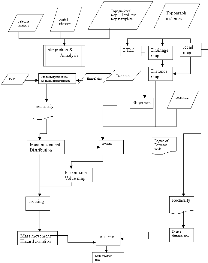
Figure 1: Flowchart of methodology.
The data that used are :
- Topographic map and digital elevation data, which later on were used
for DTM generation.
- Geology map
- Land use map
- Distance map that generated from fault, drainage and road map
respectively
- Remotely sensed data: satellite data and aerial
photographs
The analysis used for the landslide hazard was the Information Value Method developed by Yin and Yan (1988), and can be applied both to land units as well as on a pixel basis in the calculation. However as the study area was not split into small land units, like rock units used by Yin and Yan (1988) or sub-catchments areas used by van Wes ten (1993), the pixel basis was suggested for use in the calculation
The calculation applied to this hazard information method is based on the following formula, as for the calculation the information value Ii for variable Xi:
I=log (Si/Ni)/(S/N)
In which:
Si= the number of pixels with mass movements and the presence of variable Xi
Ni= the number of pixel with variable Xi
Ni= the total number of pixels with mass movements
N= the total number of pixel
The degree of hazard for a pixel j is calculated by the total information value Ij:
Ij= mSi=0 Xij Ii
In which :
M= number of variables
Xij= 0if the variable Xi is not present in the pixel j and 1 if the variable is present
The bigger the Ij valve is, the more unstable pixel j within the slope.
Result and Discussion
The relation of information value with causative factor maps blow shown the most
Relevant factors influencing the mas movement occurrences in the area . the factor maps are
- Distance from road
- Landuce
- Classified slopeand
- Distance from river
Less. Table1 and figure2 blow shows an example of ralation of the information value with the causative factore map.
| Classified distance | No pixel | Area (sq.m) | Density in map | Densty in class | Information value |
| 0 | 1798254 | 179825400 | 0.007566394 | 0.005595091 | -0.301827 |
| 1 | 25892 | 2589200 | 0.007566394 | 0.003301587 | 1.473272 |
| 2 | 22506 | 2250600 | 0.007566394 | 0.04744773 | 1.835912 |
| 3 | 23142 | 2314200 | 0.007566394 | 0.04403685 | 1.776131 |
| 4 | 21996 | 2199600 | 0.007566394 | 0.03237869 | 1.453784 |
| 5 | 20556 | 2055600 | 0.007566394 | 0.02044415 | 0.99396 |
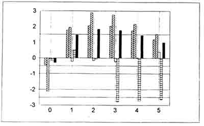
Figure 2: the graph of information value for each classified distance for man road to all types of mass movements type of mass movement are put according to slide, flowslide, flow avalanche and all types in each class. Y- axis represents information value whereas X- axis represents classified distance.
The risk map that was generated from hazard zonation and degree of damages table was subdivided into five arbitrary classes from very low to very high risk.
Conclusion
Based on the hazard zonation and risk assessment prediction, some of the area needs much more careful consideration taken of their especially the areas where lives and properties are involved. very high risk areas cover 165,600 m2; the most important of them are listed below:
- Sloping areas either at the road slope or in the market gardening
areas in Bertam Valley,Ringlet.
- Some areas in tanah Rata, especially the area located at the edge of
urban area unit which is normally either bounded by hill slope or where
building is done on the constructed earthfill slope.
- Some areas of slope along the main road which are parallel to the
Bharat tea Planation.
- Several road slopes areas in Berinchang ( north of Tanah Rata).
- Similarly, road slopes in Ringlet, approaching the Sultan Abu Bakar
Lake.
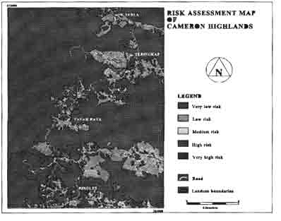
Figure 3: Risk assessment map of Cameron Highlands
References
- Hansen, A,1984 Landslide Hazard Analysis. In slope Insrability, (D.
Brunsen and
D.B Prior eds.), Johan Wiley & Sons, New York,pp. 523-602.
- Hartlen, J. and Viberg, L.,1988 General Report: Evaluation of
Landslide Hazard. In
Proseedings 5th International Symposium on Landslide, ( C.Bonnrad, ed.), A.A.Balkema, Rotterdam The Netherlands, vol.2, pp.1037-1057.
- Van westen, C.J.,1993. Application of geographical Information
System to Landslide
Hazard Zonation. ITC Publication, No.15, Enschede, The Nertherlands, 245p.
- Varnes, D.J.,1984. Hazard Zonation: A Review of Principal and
Practice. Commission of
Landslide of IAEG, UNESCO, Natural Hazades, No.3,61 p.
- Yin, K.L. and T.Z.1988. Statistical Prediction Model for Slope
Instability of
Metamophosed Rocks. In Proceedings 5th International Symposium on landslides, Lausanne (C.Bonnard, ed.), A.A.Balkema,Rottterdam, the Netherlands, Vol.2, pp.1269-1272