| GISdevelopment.net ---> AARS ---> ACRS 1997 ---> Digital Image Processing |
Fractal Surface Dimension for
Classification of Remotely Sensed Data
H. T. Ewe1, H.
K. Low2 and H. T. Chuah1
1Faculty of Engineering,
Universiti Telekom,
Bukit Beruang,
75450 Melaka, Malaysia
Tel : (60)-6-252-3507 Fax : (60)-6-231-6552
Email :htewe@unitele.com.my
2Department of Electrical Engineering
University of Malaya,
50603 Kuala Lumpur, Malaysia
Abstract 1Faculty of Engineering,
Universiti Telekom,
Bukit Beruang,
75450 Melaka, Malaysia
Tel : (60)-6-252-3507 Fax : (60)-6-231-6552
Email :htewe@unitele.com.my
2Department of Electrical Engineering
University of Malaya,
50603 Kuala Lumpur, Malaysia
It is generally found that natural objects possess self-similarity and self-affinity in their structures. Fractal analysis, a technique based on these properties, has been widely used in various research applications [1]. In the active remote sensing of the earth terrain, it is possible to extract this fractal information from the images obtained. In this application, fractal surface dimension, an important parameter in fractal analysis, can be employed as an additional feature to classify different landuse areas. This fractal surface dimension is generally related to the roughness of the surface. By keeping the x and y coordinates of the pixels of the image, and taking the grey level of each pixel as its z coordinate, a three-dimensional surface can be constructed. The calculation of fractal surface dimension can then be carried out on that surface. However, in order to obtain a good ensembled average of fractal surface dimension, a proper window size must be selected to capture the real textural information of that area. This process is normally lengthy and repetitive. In this paper, a modified fractal surface dimension based on dimension normalization technique is proposed. A study is made to compare the conventional and the modified fractal surface dimensions with different window sizes. It is found that the values of modified fractal surface dimension are more stable than those of the conventional one across different window sizes. In addition, the distribution of the modified fractal surface dimensions for six land use classes is more distinctly separable from that of the conventional fractal surface dimensions. This indicates that the modified fractal surface dimension is a useful input feature for landuse classification in remote sensing images such as SAR and Landsat TM data [2].
Introduction
For centuries, people have been using simple ideal forms such as spheres, cylinders and cubes to model the real world. It is believed that complex structures can be broken down into smaller and more regular basic forms, this will not only simplify the structure but also make the problem easy to deal with. However, since the 19th century, through the work of Koch, Hausdroff, Cantor, Sierpinski and lately Mandelbrot [1], scientific community has been exposed to a new field of science called fractal analysis. It is found that natural objects, though complex in structure, generally possess self-similarity and self affinity ( a more general relationship). This property of the natural objects is also scale invariant. Recently, there has been a great number of findings in applying fractal analysis in various scientific and engineering fields such as acoustics, clustering of galaxies, Brownian statistics, aggregation of molecules, mathematics and image compression [3]. In earth terrain image processing, a number of research activities have also been carried out to exploit the close relationship between the natural surface and the earth images [4-5]. Fractal surface dimension [6], the basic quantity in characterizing fractals, is also widely used in the image classification process [5-7]. However, the calculated fractal surface dimension is usually affected by the window size of the surface image selected. In this paper, a modified surface fractal dimension which gives stable values across multiple window sizes is proposed. This attempt is based on the dimension normalization technique. The SAR image used in this study was taken in Sungai Petani Area in Kedah state, Malaysia under the GlobeSAR program in 1993. Six landuse classes are chosen from the data set and both the modified and the conventional fractal surface dimensions of the pixels in respective classes are calculated. The study shows that the six landuse classes are more clearly separated out in the distribution graph of the modified fractal surface dimension compared to that of the conventional fractal surface dimension. Thus, the modified fractal surface dimension will be a good input candidate for further classification processes.
Fractal Surface Dimension
The familiar Euclidean dimension of the physical world is expressed as an integer such as in 2-dimensional space (flat surface0 and 3-dimensional space (solid object). The peculiar property of the fractal dimension is that it allows fractional dimension. This fractal dimension is defined as [1,5]
| D = | log
N ------------- Log (1 / r) |
(1) |
Where D is the fractal dimension, N is the number of the scaled down copies (with linear dimension r) of the original objects which is needed to fill up the original objects. Taking the example of a flat square surface of unit area (1x1), if we scale down this unit area surface to a small square of size r x r, and then use this scaled down squared to fill up the original unit area surface, it is found that a total number o N (N = L2, where L = 1/r) scaled down squares are needed. For this flat surface case, Equation 1 gives
| D = | log
L2 ------------- Log L |
(1) |
Some fractal surfaces are generated using the midpoint displacement method [8], and shown in Figure 1. It is found that the fractal surface dimension corresponds closely to our general conception of the roughness of the surface.
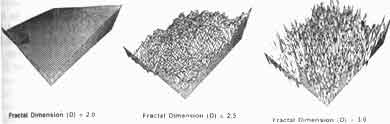
Figure 1: Surfaces of different fractal dimensions
In order to apply the fractal analysis to the SAR images, it is necessary to construct a virtual 3-D surface from the image. This is realized by treating the intensity value of the image (gray level) for each pixel (with coordinated x and y) as the height h of the 3-D surface. The x and y coordinates of a particular point on the 3-D surface correspond respectively to the x and y coordinates of the pixels in the original SAR image. Covering method [7] is used to calculate the fractal surface dimension of each point on the constructed 3-D surface. A square window W of size L unit x L unit (centered at x0y0) is first chosen and the corresponding 3-D surface within the boundary of the window is constructed. This is followed by the normalization of the heights (h) of all the selected surface points within the window as shown below:
| hn = | h*l ------------- H |
(2) |
Where hn is the normalized height and H (=255) is the maximum gray level of 8-bit SAR image. The normalization is required to ensure that the calculated fractal surface dimension is within the limit of 3.0. After that, using the small square of size 1 unit x 1 unit as the basic measuring unit, the number of small squares needed to fill up the total 3-D surface within the window is calculated. The fractal surface dimension calculated using Equation 1 will then be assigned to the center pixel (x0y0), and by using the sliding window technique, the center of the window is moved to the adjacent pixel to calculate the fractal surface dimension of that pixel.
It is commonly found that small areas of different landuse regions are abundant in the SAR image. This is especially true for areas surrounding the urban district and areas with mixed plantation. In order to discriminate them from one another, it is reasonable to choose small window size (and thus small 3-D constructed surface) for the calculation of fractal surface dimension. However, due to the normalization process used in the conventional method elaborated above, the variation between the normalized heights (hn) of the pixels within the window becomes less distinct, and thus leads to the small difference in the calculated local fractal surface dimension of different classes. In addition, the fractal surface dimension calculated using the conventional method varies with the window size chosen. Therefore, a new method based on dimension normalization technique is developed. This modified method requires no height normalization of the constructed 3-D surface. The same windowing technique is applied and the original values of the intensity of the pixels are retained, and the 3-D virtual surface is constructed as stained above. The height normalization step is no longer performed. Using the same square of size 1 unit x 1 unit as the basic measuring unit, he total number of square (N') needed to cover the surface is calculated . This calculated N' is later normalized by the base surface area of size L unit x L unit. This flat base surface area has a physical dimension of 2 and is also equal to the window size. The normalized N' (N'n) can be related to the maximum gray level H by the power law [3] as shown below:
| N'n = | N' ------------- (L*L) |
= Hf (3) |
where f is the partial fractal surface dimension. Taking logarithm of both sides of Equation 3 and rearranging it, we have
| f = | log(N'n) ------------- log(H) |
(4) |
and the modified local fractal surface dimension Dd is obtained by adding the physical dimension of 2.0 to f, as follows:
Results and Discussion
In this study, SAR images of Sungai Petani area with three polarizations (HH, VV, HV) taken during the GlobeSAR mission in November 1993 are used to calculate the fractal surface dimension (D) and the modified fractal surface dimension (Dd). The calculated D and Dd for window sizes from 3 x 3 to 25 x 25 for HV polarization are shown respectively in Figures 2a and 2b.
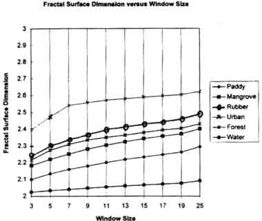
Figure 2a : Conventional fractal surface dimension versus window size for SAR HV image.
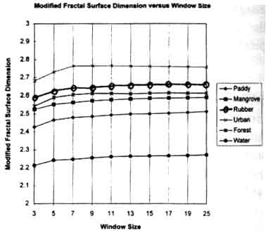
Figure 2b: Modified fractal surface dimension versus window size for SAR HV image.
Six different landuse classes (paddy, mangrove, rubber, urban, forest and water) are chosen for this comparison. It is shown that the modified fractal surface dimension gives constant values across window sizes of 7 x 7 to 25 x 25, as compared to that of the conventional fractal surface dimension which increases a window size becomes larger. The difference between the modified fractal surface dimensions for small window size (3x3 and 5x5) and those of large window size in understandable, as smaller window fails to capture the whole textured information for each class of landuse area. The same trend is observed using the SAR images of HH and VV polarizations. The stability of the modified fractal surface dimension calculated across a range of window sizes is important in eliminating extra time spent in determining the optimum window size or fractal analysis in SAR classification process.
Using the window size of 7 x 7, the distributions of fractal surface dimension and modified fractal surface dimension for six landuse classes are plotted respectively in Figures 3a and 3b. SAR image of Sungai Petani area for HV polarization is also used in this calculations.
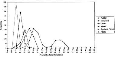
Figure 3a: Distribution of conventional fractal surface dimension for six landuse classes
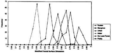
Figure 3b: Distribution of modified fractal surface dimension for six landuse classes
From Figure 3a and 3b, it is clearly sown that the distributions of the modified fractal surface dimension for various landuse classes are more easily separated from those of the conventional fractal surface dimension. Three categories of landuse classes (namely urban vegetation and water) can further be determined from Figure 3b. Among the different landuse classes in the vegetation category, it is notices that the paddy areas has the lowest modified fractal surface dimension, followed by mangrove, rubber and dry land forest. The homogeneous water body beneath the paddy crops and mangrove may play its role in giving lower modified fractal surface dimension.
Conclusion
The modified fractal surface dimension proposed in this paper is a stable local parameter across a wide range of window sizes for different landuse classes. In addition, it manages to separate those classes easily. Therefore, together with other statistical parameters, this modified fractal surface dimension can serve as a good input feature to be used in further classification processes such as artificial neural network classification and conventional supervised classification.
References
- B. B. Mandelbrot, The Fractal Geometry of Nature, Freeman, San Francisco, CA, 1982.
- H. K. Low, H. T. Chuah and H. T. Ewe, "Windowing Technique in Artificial Neural Network Classifier for Landuse Application", Proceedings of 1st Annual Malaysian Remote Sensing and GIS Conference, Kuala Lumpur, 25-27 November, 1996.
- M. Schroeder, Fractals, Chaos, Power Laws, Freeman, New York, 1991.
- A. P. Pentland, "Fractal-Based Description of Natural Scenes", IEEE Transactions on Pattern Analysis and Machine Intelligence, Vol. 6, No. 6, Nov. 1984, pp. 661-674.
- J. M. Keller, S. Chen and R. M. Crownover, "Texture Description and Segmentation through Fractal Geometry", Computer Vision. Geographics, and Image Processing , 45, 1989, pp. 150-166.
- B. B. Mandelbrot, "Self-Affine Fractals and Fractal Dimension", Physica Scripta, Vol. 32, 1985, pp. 257-260.
- H. T. Ewe, W. C. Au, R. T. Shin and J. A. Kong, "Classification of SAR Images Using a Fractal Approach", Proceedings of Progress in Electromagnetic Research Symposium (PIERS), Los Angles, U.S.A., 1993, pp. 493.
- M. F . Barnsley, R. L. Devaney, B. B. Mandelbrot, H. Peitgen, D. Saupe and R. F. Voss, The Science of Fractal Images, Springer-Verlag, 1988.