| GISdevelopment.net ---> AARS ---> ACRS 1997 ---> Digital Image Processing |
A Fractal Approach to the
Classification of Land Cover in Radar imagery
Randy John N. Vinluan, Mark
J. Encarnacion, Epifanio D. Lopez, Guillermo Q. Tabios
College of Engineering, University of the Philippines
Dliman, Quezon City 1101 Metro Manila, The Philippines
Tel : (63 2 ) 434-3633; Fax (63 2) 922-4714
Email :rjnv@engg.upd.edu.ph, edl@engg.upd.edu.ph
Abstract College of Engineering, University of the Philippines
Dliman, Quezon City 1101 Metro Manila, The Philippines
Tel : (63 2 ) 434-3633; Fax (63 2) 922-4714
Email :rjnv@engg.upd.edu.ph, edl@engg.upd.edu.ph
Fractals are useful in remote sensing image analysis because of the self-similarity and scaling properties inherent in satellite imagery. This stud sought to determine whether fractal analysis is a useful means for characterizing land cover in radar imagery. It also sough to determine how speckle filtering affects the computed fractal dimension and whether this will enhance classification. Thirty ERS-1 synthetic aperture radar images of seven land cover types present in Central Luzon (bay areas, forested areas, mountainous terrain, rice fields, river areas, urban areas, and wetlands) were represented as a three-dimensional backscatter surface with the pixel and line coordinates of the image serving as the x- and y- coordinates of the backscatter surface and the backscatter intensity as the z-coordinate. Using two methods for computing the fractal dimension - the triangular prism surface area method and the box-counting method- four fractal parameters are computed : the Fract3D dimension, capacity dimension, information dimension, information dimension, and correlation dimension. A multivariate statistical method called multiple discriminant analysis is applied to these parameters, as well as to two other statistical measures - the image mean and standard deviation - to determine the separation between the different land cover types. Results show that all six parameters significantly separate the seven land cover types. Including all fractal and statistical measures in the multiple discriminant analysis yields an observed classification accuracy of 70.95%, or a kappea coefficient of about 0.66.Speckle-filtering results in an image set with totally different fractal and statistical properties from the original, with the exception of the capacity dimension for bay areas and the information dimension for urban areas. This resulted in an improvement of the classification to 80.48%, or a kappa coefficient of 0.77.
Introduction:
Fractals are mathematical models for very irregular and very detailed characterized by the so-called fractal dimension (Stoyan and Stoyan, 1994). Just as a Euclidean curve has a topological dimension of 1, and a Euclidean plane has a topological dimension of 2, a fractal curve has a dimension between 1 and 2, and a fractal surface has a dimension between 2 and 3, depending on the degree of complexity (Lam, 1990). Furthermore, fractals are characterized by self-similarity and scaling (Peitgen, et al., 1992), which means that the characteristics of fractals can be identified at all scales of observation, although our ability to visualize them is limited by the resolution of the computer screen (Shibli, 1996).
Remote sensing digital image analysis is an appropriate field for the application of fractals because of the inherent significance of self-similarity, both strictly and statistically (Quattrochi and Lam, 1991; Goodchild and Mark, 1987); scale, both spatial and temporal (Ridd, 1991; Goodchild and Mark, 1987); and patterns and processes (Davis, 1991) in geographic entities.
Fractal analysis of remotely-sensed images, although relatively new, seems to have great potential (Quattrochi and Lam, 1991). The research direction is clearly toward the further exploration on the use of fractals to characterize, measure, and even simulate (Carr, 1995) earth patterns and processes over space and time.
Objectives:
The general objective of this study is to determine whether fractal analysis is a useful means for characterizing different tropical land cover types. In particular, the study seeks to find most effectively between the different land cover types?; and 2) Does speckle filtering enhance classification?
Methods:
Three ERS-1 SAR scenes of Central Luzon dated July 25, August 29, and October 3, 1993 were used in the study. For easier manipulation, each pixel in the images was requantizd to 8-bit, without significant loss of information, from an original radiometric resolution of 16 bit per pixel. Using as reference recent aerial photographs, ground truth data, and existing topographic and land cover maps, seven tropical land cover types were identified - bay areas, forested areas mountainous terrain, rice fields, river areas, urban areas, and wetlands. Thirty 129 pixel by 129 line subsets for each land cover type, or a total of 210 image subsets, were extracted from the three ERS-1 SAR scenes. The image subsets were represented as a radar backscatter surface with the x- and y- coordinates corresponding to the pixel and the coordinates respectively, and the z-coordinate corresponding to the radar backscatter intensity . Figure 1 shows the ERS- SAR scene of Central Luzon dated July 25, 1993 and sample regions where the different land cover types were extracted.
Four representations of the fractal dimension- the Fract3D dimension (Fract3D), derived using the triangular prism surface area method (Clarke, 1986), and the capacity (CapDim), information (InfDim) and correlation (CorrDim) dimensions, derived using the box-counting method (Rasband, 1990)-as well as two first-order statistical measures, the image mean and standard deviation, were computed for each of the image subsets representing different land cover types. The fractal dimensions are interpreted as measures of radar backscatter surface complexity.
A multivariate statistical method called multiple discriminant analysis, which exhibits some similarity with principal component analysis, was applied to the computed fractal and statistical measures. This method aims to compute a set of linear or discriminant functions which best separate a set of , in this case, 7 groups. These discriminant functions represent coordinate axes in the p-dimensional space defined by the p (in this case, 6: the four fractal dimensions, the image mean, and the standard deviation) spectral bands making up the data (Mather, 1987).
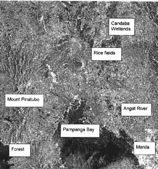
Figure 1, ERS-1 SAR Scene of Central Luzon dated July 25, 1993
A 5 x 5 Lee filter, which is an adaptive speckle-reduction filter, was applied to the same set of images. The four fractal and two first-order statistical measures were computed for the new set of image subsets. Student's test was applied to the original and speckle-filtered data in order to determine whether there were significant differences between the two sets of data. Finally, multiple discriminant analysis was also applied to the speckle-filtered datasets in order to determine whether speckle-reduction filtering enhances fractal-based classification.
Results:
Table 1 shows the averaged values for the fractal and first-order statistical measures computed for the original dataset. Urban areas, mainly because of the presence of corner reflectors such as buildings and houses, registered the highest average radar backscatter, while bay areas, owing to the presence of specular reflectors such as calm sea surface and oil spills, registered the lowest average radar backscatter. The dielectric properties of the land cover show promience in the SAR intensity image as shown by the fact the "wet" classes such as bay areas, river areas and wetlands have low backscatter values while "dry" classes such as mountainous terrain and urban areas have high backscatter values.
Urban areas have the highest Fract3D and CapDim values while forested areas have the highest InfDim and CorrDim values. On the other hand, bay areas have the lowest Fract3D and CapDim values while urban areas have the lowest InfDim and CorrDim values.
| Mean | SD | Fract3D | CapDim | InfDim | CurrDim | |
| Bay | 103.14 | 31.78 | 2.35844 | 2.21692 | 2.53970 | 2.56609 |
| Forest | 146.79 | 44.87 | 2.39759 | 2.31883 | 2.62425 | 2.63461 |
| Mountain | 153.29 | 52.72 | 2.38655 | 2.31784 | 2.57592 | 2.53493 |
| Rice | 138.56 | 45.00 | 2.38733 | 2.28655 | 2.58937 | 2.60590 |
| River | 146.02 | 46.15 | 2.38209 | 2.30249 | 2.59268 | 2.59480 |
| Urban | 196.13 | 49.17 | 2.43025 | 2.43996 | 2.50514 | 2.43740 |
| Wetland | 130.62 | 47.07 | 2.37199 | 2.27743 | 2.54952 | 2.55889 |
A stepwise entry method for the four fractal and two-first order statistical measures into the multiple discriminant analysis showed that the all six measures significantly separate the land cover types under study. Table II shows the coefficients of the discriminant functions as well as their eigenvalues and discriminating power (in%).
| Func 1 | Func 2 | Func 3 | Func 4 | Func 5 | Func 6 | |
| Mean | 0.52605 | 0.09352 | -0.42143 | 0.60039 | 1.11546 | -0.45859 |
| StDev | -0.09889 | 1.03309 | -0.17043 | 0.57872 | -0.09337 | 0.26626 |
| Fract3D | 0.32973 | -0.26088 | 0.67790 | -0.47630 | 0.29160 | 0.54774 |
| CapDim | 0.69605 | -0.12868 | 0.41142 | 0.18981 | -0.97482 | -0.15351 |
| InfDim | 0.02065 | 1.27824 | -0.97654 | -2.83297 | -0.29363 | -0.00875 |
| CorrDim | -0.96785 | -0.42771 | 1.54715 | 2.37210 | 0.14065 | -0.15488 |
| Eigenval | 7.61760 | 0.95890 | 0.43070 | 0.16390 | 0.01260 | 0.00900 |
| DiscPower | 82.87 | 10.43 | 4.68 | 1.78 | 0.14 | 0.10 |
The first three discriminant functions already account for 98% of the discriminating power between classes. The first discriminant function is dominated by the mean, Fract3D, CapDim, and CorrDim. The second discriminant function is dominated by the standard deviation, InfDim, and CorrDim. The third discriminant function is dominant by the mean, Fract3D, InfDim, and CorrDim.
Land cover classification can be done based on these discriminant functions. Table III above shows the accuracy matrix for the classification of the original SAR images. The observed accuracy is 70.95% while the kappa coefficient is equal to 0.66. Bay areas, forested areas, mountainous terrain, and urban areas registered classification accuracy rates of over 75%. Twenty SAR image subsets, on the other hands, were erroneously labeled as "rice fields".
| Bay | Forest | Mountain | Rice | River | Urban | Wetland | ||
| Bay | 24 | 0 | 0 | 1 | 4 | 0 | 1 | 30 |
| Forest | 0 | 23 | 1 | 4 | 1 | 0 | 1 | 30 |
| Mountain | 0 | 2 | 27 | 1 | 0 | 0 | 0 | 30 |
| Rice | 1 | 4 | 0 | 18 | 6 | 0 | 1 | 30 |
| River | 2 | 4 | 2 | 4 | 17 | 0 | 1 | 30 |
| Urban | 0 | 0 | 0 | 0 | 0 | 30 | 0 | 30 |
| Wetland | 1 | 2 | 0 | 10 | 7 | 0 | 10 | 30 |
| 28 | 35 | 30 | 38 | 35 | 30 | 14 | 210 |
Student's t-test revealed that speckle filtering generated a set of SAR images satistically different from the original Speckle filtering resulted in a decrease in the computed values for the six parameters. This is due to the smoothening effect of the filter. Table IV gives the statistical summary of computed fractal and first-order statistical measures for the filtered set of images. Urban areas and mountainous terrain remained to be the "brightest" land cover while bay areas and wetlands remained to be the "darkest" features. Wetlands have the lower average CapDim, InfDim, and CorrDim values. Urban areas and mountainous terrain continued to have high fractal dimensions.
| Mean | SD | Fract3D | CapDim | InfDim CorrDim | ||
| Bay | 97.32 | 24.44 | 2.21061 | 2.21111 | 2.41131 | 2.39354 |
| Forest | 142.91 | 34.12 | 2.24125 | 2.20987 | 2.49377 | 2.53643 |
| Mountain | 152.37 | 38.88 | 2.27388 | 2.26826 | 2.48999 | 2.49033 |
| Rice | 134.81 | 36.53 | 2.24070 | 2.22692 | 2.41507 | 2.43872 |
| River | 142.02 | 38.49 | 2.24840 | 2.21636 | 2.40033 | 2.42013 |
| Urban | 190.53 | 45.49 | 2.21456 | 2.24969 | 2.49954 | 2.49142 |
| Wetland | 126.91 | 39.35 | 2.23532 | 2.20642 | 2.35461 | 2.63273 |
All six measures contributed significantly to the separation of the land cover types under study. Table V shows the coefficients of the discriminant functions as well as their eigenvalues and discriminating power (in%). The first three discriminant functions account for 97% of the class separation. The first discriminant function is dominated by the image mean, standard deviation, and CapDim. The second discriminant function is dominated by the standard deviation. InfDim, and CorrDim. The third discriminant function is dominated by Fract3D, InfDim, and CorrDim.
| Func 1 | Func 2 | Func 3 | Func 4 | Func 5 | Func 6 | |
| Mean | 0.94309 | 0.00252 | -0.3751 | 0.38288 | 0.30395 | -0.51350 |
| StDev | 0.57446 | -0.46839 | 0.02611 | -0.50715 | -0.38857 | 0.47193 |
| Fract3D | 0.07675 | -0.01281 | 0.93512 | 0.69148 | -0.20007 | -0.43265 |
| CapDim | 0.34304 | -0.11795 | -0.28736 | 0.49641 | 0.85135 | 0.62269 |
| InfDim | -0.10600 | 0.40152 | -0.83084 | 0.54076 | -1.09403 | -0.14795 |
| CorrDim | 0.13025 | 0.62739 | 0.69037 | -0.82953 | 0.59237 | 0.40506 |
| Eigenval | 3.06220 | 0.61610 | 0.24590 | 0.11340 | 0.00680 | 0.00600 |
| DisPower | 75.60 | 15.21 | 6.07 | 2.80 | 0.17 | 0.15 |
Results of the classification process based on these discriminant functions showed an improvement in the accuracy from 70.95% to 80.49. The keepa coefficient improved to 0.77. With the exception of "rice fields",all the classes registered classification accuracies of at least 70%.
Again, a large number (22) of SAR images were erroneously classified as "rice fields". This difficulty in the classification of rice may be due to the dependence of the radar backscatter on the growing stage the crop is in. These results are shown in Table VI.
| Bay | Forest | Mountain | Rice | River | Urban | Wetland | ||
| Bay | 24 | 1 | 0 | 2 | 1 | 0 | 2 | 30 |
| Forest | 1 | 20 | 0 | 4 | 0 | 0 | 0 | 30 |
| Mountain | 0 | 1 | 29 | 0 | 0 | 0 | 0 | 30 |
| Rice | 0 | 3 | 0 | 22 | 1 | 0 | 4 | 30 |
| River | 0 | 1 | 0 | 11 | 14 | 0 | 4 | 30 |
| Urban | 0 | 0 | 0 | 0 | 0 | 30 | 0 | 30 |
| Wetland | 0 | 0 | 0 | 5 | 1 | 0 | 24 | 30 |
| 25 | 32 | 29 | 44 | 17 | 30 | 34 | 210 |
Conclusion:
This study sought to determine whether fractal-based analysis is a useful means for characterizing tropical land cover. Results of the discriminant analysis show that the four fractal and two statistical parameters contribute significantly to class separation and that a classification accuracy of up to 71% may be achieved. Speckle-reduction filtering results in a new set of SAR imagery with significantly different fractal and statistical properties. This also results in an improvement in classification to 80%.
References:
- Carr, J. R. (1995)Numerical Analysis for the Geological Sciences, Prentice-Hall, Inc. New Zersey, pp. 489-530.
- Clarke, K. C. (1986)Computation of the Fractal Dimension of Topographic Surface Using the Triangular Prism Surface Area Method, Computers & Geosciences, v. 12, no. 5, pp. 713-722.
- Davis, F. W. (1991) Processing of GIS and Remotely Sensed Data for Environmental Analysis, Proceedings of the Conference on the Integration of Remote Sensing and Geographic Information Systems, Baltimore, pp. 137-149.
- Goodchild, M. F. and Mark, D. M. (1987). The Fractal Nature of Geographic Phenomena, Analysis of the Association of American Geographers, v. 77, no. 2, pp. 265-278.
- Mather, P. M. (1987) Computer Processing of Remotely-Sensed Images, John Wiley & Sons, Inc., Chichester, pp. 218-226.
- Peitgen, H. O., Jurgens, H. and Saupe, D. (1992) Chaos and Fractals (New Frontiers of Science), Springer-Verlag, Berlin, pp. 138-181, 721-744.
- Peitgen, H. O. and Richter, P. H. (1986) The Beauty of Fractals (Images of Complex Dynamical Systems), Springer-Verlang, Berlin, p. v.
- Quattrochi, D. A. and Lam, N. S. (1991) Perspectives on Integrating Multiscale, Multitemporal Remote Sensing Data with Geographic Information System, Proceedings of the Conference on the Integration of Remote Sensing and Geographic Information Systems, Baltimore, pp. 151-165.
- Rasband, S. N. (1990) Chaotic Dynamics of Nonlinear Systems, John Wiley & Sons, Inc., New York, pp. 72-78.
- Ridd, M. K. (1991) Spatial and Temporal Scaling Issues Related to the Integration of GIS and Remote Sensing, Proceedings of the Conference on the integration of Remote Sensing and Geographic Information Systems, Baltimore, pp. 167-173.
- Shibi, S. A. R. (1996) Calculation of the Fractal Dimension, The Al-GEOSTATS Newsletter, v. 1, no. 1.
- Stoyan, D. and Stoyan, H. (1994) Fractals, Random Shapes and Point Fields, John Wiley & Sons, Chichester, p. 3.