| GISdevelopment.net ---> AARS ---> ACRS 1997 ---> Digital Image Processing |
Advanced Image Processing
Tools for Future Satellite Image Exploitation Systems
Jacques-Ariel Sirta, David
Canu Frederic Perlant, Laurent Peytavin and Nicholas
Ayache
Laboratoire de Traitement des Images et du Signal
Matra Systemes et Information
6, rue Dewoitine
F-78142 Velizy-Villacoublay-France
Tel : 33-1-34.63.76.09 Fax : 33-1-34.63.76.23
Email :asirat@mantra-ms2i.fr
Abstract
Laboratoire de Traitement des Images et du Signal
Matra Systemes et Information
6, rue Dewoitine
F-78142 Velizy-Villacoublay-France
Tel : 33-1-34.63.76.09 Fax : 33-1-34.63.76.23
Email :asirat@mantra-ms2i.fr
Image processing is a key technology for operational exploitation of satellite images. Beyond image quality considerations, a crucial issue consists in providing the final user with real-time value-adding tools. We have followed a progmatical approach in transferring the most promising image processing algorithms from fundamental research to operational systems. This is discussed on automatic change detection, automatic extraction of 3D models from high resolution images and on selective compression for dissemination through communication networks.
Introduction
During the last decade, remote sensing applications of satellite imagery have been investigated through an 'experimental' approach: a few imaging satellites have been launched and exploited by national space agencies in order to demonstrate the feasibility of remote sensing applications in the field of cartography, resource or disaster monitoring, etc. (see for example [1-4]. In the future decade, we should get into an 'operational' phase with a significant number of observation satellites-including commercial programs-covering a large spectrum of sources from optical (multi-spectral or high resolution) to SAR sensors. Moreover, access times shorten rapidly, due to higher revist frequency provided by multi-satellite ground stations and to dissemination through communication networks. This paves the way to operational, quasi-real-time exploration systems.
In these systems, image processing is a key-technology for :
- guaranteeing image quality,
- establishing and exploiting the complementarity between the various sources,
- providing (semi)-automatic tools for real-time applicative exploitation and dissemination towards the end-user.
From Fundamental Research to Operational Systems
Our approach to bridge the gap between academic research and operational systems is based on simple and pragmatical principles:
- identifying in the Research Community the most relevant image processing emerging methods,
- evaluating those methods in comparison with state-of -the-art approaches using satellite images or simulations and ground truth data,
- taking into account constraints at system level (revisit time, application specific issues, available data etc.),
- evaluation mock-ups of operational tools based on the selected methods through 'proof of concept' demonstrations by application specialists.
- multi band/ multipolarized SAR data,
- SAR interferometry,
- hyperspectral data.
MATRA Systems & Information has led a European consortium of 9 scientific partners in a project for the European Space Agency (ESA/ESRIN). The INSAR project aimed to evaluate and quantify the relevance of RS-1/2 Interferometry data for the following applications:
- production of Digital Elevation Models for cartography [5],
- Hydrology using detailed terrain models,
- Forestry (estimation of forest parameters and changes),
- Glaciology (measurement of small motions using differential interferometry),
- Earth Science (studying earthquakes and volcanoes).
Multi-band /multipolarised SAR data
L and C-band SIR-C data have been used to evaluate relevance for agriculture applications. Data available on a test site, and completed with optical both visible and infrared images have been processed using advanced low-level image processing tools (classification and segmentatin0. Information theory measures allowed to quantify the mutual relevance of these data for classifying fields with different cultures [6-7].
Hyperspectral image data
Future observation satellites may load hyperspectral sensors, ie. Imaging instruments which provide an actual chemical spectrum measurement on each pixel (up to 200 channels with down to 10 nm width). We have simulated such images using AVIRIS data. Sophisticated image processing tools allow to classify the pixels using the spectral information (classification according to the materials observed) [8].
Towards Real-Time Exploitation
The huge image data flow available in multi-satellite receiving stations requires automatic tools for processing, exploiting and disseminating the information towards the end-user. We present here results obtained on three relevant tool families:
- automatic change detection,
- automatic extraction of high resolution elevation models,
- selective image compression.
In many monitoring applications (agriculture, urban areas…), a given site is observed many times. The relevant information is the change between two successive images. Simple methods like image difference are here completely uneffective due eg. To illumination changes or to fine (subpixel) misregistration. We have developed a complete scheme based on fine registration and on structured detection. Moreover, a specific Man Machine Interface has been realized to present first the most relevant changes defected.
Automatic extraction of high resolution Digital Elevation Models
From 98 on, high-resolution optical images should be avaible from commercial programs like Earthwatch or Space Imaging. Detailed mapping of urban areas is a key application of these data. Up to now, this application required tedious manual operations due to inage complexity. Fig. 1 presents results of fully atuomatic extraction of high resolution Digital Elevation Models using two or more inages. This novel methods is based on sophisticated dence correlation tools developped in our laboratory [9].
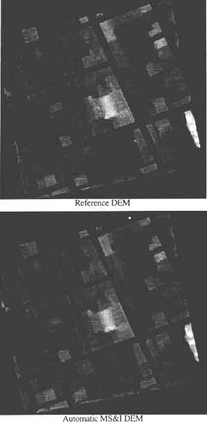
Fig. 1 :High Resolution Digital Elevation Model (DEM) obtained automatically from a stereo pari of aerial images (Marseille-France). This zone exhibits roofs and walls which cannot be handled by standard correlation methods used to produce medium resolution DEMs (eg. from 10m SPOT stereo pairs). Here, a highly sophisticated correlator developed by MATRA Systemes et Information has been used (bottom). Comparison with manually derived DEM on the same (Image and reference DEM data : courtesy ISTAR, France)
Selective image compression
Fast access to satellite image data is now possible through communication links. However, depending on the bit-rates available, transfer times may remain quite long. We have developed novel compression methods which combine effectiveness of compression standards (JPEG etc.) and application-specific automatic tools. This allows to focus the communication resource (bitrate available) on the most relevant areas/scales in the image, depending on the image contents and on the end-user's application. This novel concept of 'selective compression' is being demonstrated and evaluated in a European projects called ISIS [4]. The consortium led by MATRA Systems & Information gathers industrial partners, data brokers (SPOT Image and ESA) and end-users. Fig. 2 sow results obtained using selective compression leading to significant enhancement of compression rations.
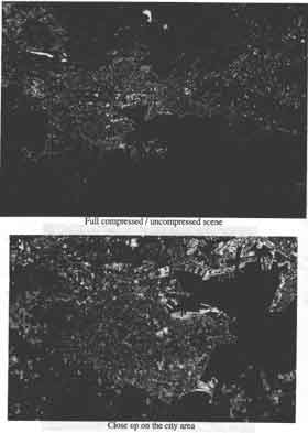
Fig. 2: Results of selective compression / decompression applied to a SPOT image on Toulon (France) for a coastal-zone thematic application. In the area of interest (coastal zone), maximum image quality (resolution) is preserved. Outside (context zone), degradation of the image resolution by a low-pass filtering leads to a high global compression ratio (40).
Acknowledgments
- The main results presented here have been obtained under contracts by European Community (DG III- Esprit 4), Delegation Generale de l'Armement (French MoD), European Space Agency or MATRA Hautes Technologies.
- Image and DEM data on Marseille have been provided by ISTAR (France).
- Bonn F. Et al., 'The Contribution of SPOT Imagery to Understanding the Dynamics Of the Red Officials Hong's Delta Environment (Vietnam)', Proc. Int. Conf. SPOT - From a Decade of Accomplishment to a Decade of Promise', Paris, Fr, 15-18 April 1996, pp. 401-411.
- 'Applications and Achievements of ERS-1', Proc. 2nd ERS Applications Workshop, London, UK, 6-8 December 1995, pp. 115-127.
- 'Radarsat Flood Imagery Rushed to U. S . Officials', Aviation Week & Space Technology, Vol. 146, N°18, p. 64.
- Sirat J. A. and Richard G., 'Progress in Access to Earth Observation Data through Information Highway', Proc. Int. Conf. SPOT-From a Decade of Accomplishments to a Decade of Promise', Paris, Fr. 15-18 April 1996, pp. 547-554 (in French).
- Tarayre H., 'Production of Digital Elevation Models from Satellite SAR Images using Interferometry : Algorithms and Atmospherical artifacts', PhD thesis, Institut National Polytechnique de Toulouse (France), 1st April 1996 (in French),
- Le Hegarat-Mascle S., 'Non Supervised Classification of Polarimetric SAR images', PhD thesis, Ecole Nationale des Telecommunications, Paris (France), 13 September 1996 (in French).
- Le Hegarat-Mascle S., Vidal-Madjar D., Taconnet O. and Zribi M. 'Application of Shannon Information Theory to a Comparison between L and C bands SIR-C. Polarimetric Data Versus Incidence Angle', accepted for publication in Remote Sensing Environment.
- Peytavin L., 'Cross-sensor Resolution Enhancement of Hyperspectral Images using Wavelet Decomposition', Proceedings SPIE AEROSENSE Symposium in Orlando, Florida, 10-12 April 1996,Vol. 2758, pp. 193-203.
- Canu D., Sirat J. A. and Ayache N., 'Accurate and Robust Stereovision with a Large Number of Aerial Images', Proc. Image and Signal Processing for Remote Sensing, Paris (Frnace), 1995.