| GISdevelopment.net ---> AARS ---> ACRS 1997 ---> Agriculture/Soil |
Pedogenesis in Relation to
Physiography in Soils of Ropar Kandi Tract (Punjab) India: A Remote
Sensing Approach
V. K. Verma*, J. Prasad**,
C. Subrahmanyam**, P. K. Sharma* and T. Harikishore*
*Punjab Remote Sensing Centre, Ludhiana, 141 004, India
** Indian Institute of Remote Sensing, Dehradun 248 001, India
*Punjab Remote Sensing Centre, Ludhiana, 141 004, India
** Indian Institute of Remote Sensing, Dehradun 248 001, India
Abstract
Morphological, physical and chemical characteristics of soils developed on different physiographic units in Ropar Kandi tract in Punjab State (Northwest India) revealed two distinct stages of pedogenic development : A-C and A-(Bw) - C profiles. The young and strafied soils from unstable landforms (hills, valley, piedmont plain, recent and active flood plan) representing newer alluvium are classified as Typic Ustipsamments, Typic Ustorthents and Typic Ustifluvents. The soils develoed on relatively stable landforms (old flood plain) show development of cambic or structural B horizon and are classified as Typic variation and thus, is separately described both for 'East and West' of Satluj River. The differences in soils developed on various physiographic units are primarily due to the nature of parent material, topography and to some extent age or time. The study established a well-defined relationship between physiography and development of soils.
Introduction
An intimate knowledge of soil resources of a region is necessary for planning any agricultural development. In this context, remote sensing have opened new vistas in soil resources surveys. The knowledge of physiographic processes as portrayed on satellite imagery in the form of surfacial features provide enough traits to delineate soil boundaries. This technology has been employed successfully for soil mapping in different parts of the World (Westin and Freeze, 1976: Gastellu- Etchegorry et al., 1990; Abd-El-Hay et. al., 1991) and in India (Sehgal et. al., 1988; Rao et. al., 1989; Kudrat et. al., 1992). Information about the pedogenesis of soils in relation to physiography in Ropar Kandi tract is lacking. With this in view, the present study was undertaken to evaluate the contribution of different soil forming factors to the development of soils from different physiographic units in the area.
General description of the Area
The study area, a part of Kandi tract in Ropar district Punjab lies between 30°50' and 31°13'N latitudes and 76°20' and 76°39' E longitudes. It has distinct physical agro-ecological characteristics which are different from those in other parts of the State. The area was undulating topography, inadequate ground water, steep slopes, bare land surfaces, lack of vegetation due to deforestation and overgrazing and problem of soil erosion. It is located both on the west and east of river Satluj, towards upstream of Ropar Headworks up to Anandpur Sahib and covers an area of 47,502 hectares. The area is bounded by Himachal Pradesh in the east and district Hoshiarpur (Punjab) in the west. Geologically, the area consists of para autochthonous upper Siwalik belt, piedmont plain and alluvial tract. The climate is the semi-arid (sub moist) and the area has ustic soil moisture regime and hyperthermic soil temperature regime.
Materials and Methods
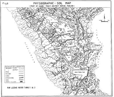
The IRS-1A LISS-II data in the form of false colour composites of November 1991 generated from bands 2,3 and 4 was visually interpreted for delineating various physiographic units viz., hills, valley, piedmont plain and flood plain. Each unit was further sub divided based on combination of tine, texture, land type, texture, pattern etc. These physiographic units have been further sub divided based on land parameters like slope, erosion, natural vegetation, drainage and landuse, which have weightage on the soil variation and land management. The study area is quite heterogeneous with respect to soil variation and thus, is separately described for both 'East of Satluj' and 'West of Satluj'. The pedons representing major soils were studied for their morphology and physico chemical properties as per standard procedures. The soils were classified as per Soil Taxonomy (Soil Survey Staff, 1975) and mapped as association of soil families. The relationship between physiography and soils was established. The final physiography - soil map was prepared on 1:50,000 scale (Fig. 1).
Results and Discussion
Physiography and Soils:
Systematic approach of image interpretation along with sufficient collateral information regarding geology, climate etc. of the area revealed the following physiographic units:
- Hills: This unit is represented by Upper Siwalik belt which
consists of massive, poorly lithified sandstone and silt stone. These
consists of beds of silt and clay with rounded pebbles and gravels. The
hills are covered with sparse vegetation, bushes and shrubs. It has
moderate to very slopes and is severely eroded. This unit is further sub
divided into
(i) Hill side slopes and
(ii) Hill foot slopes.
- Valley: The valleys are narrow to broad with gentle to moderate
slopes. The ground water is mostly at shallow depth. The valleys in the
area are found in different location and has been subdivided into
(i)Hill valley (ii) River bed in plains.
- Piedmont plain: It represents plain with a gently rolling slope at
the base of the hills, intercepted and dissected by seasonal rivulets.
This units is partly cultivated and partly under bush vegetation. The
deposits near the hills are finer - in texture, in general. This unit is
divided into (i) Upper piedmont plain (ii) Lower piedmont plain. Further
sub division is done on the basis of landuse, erosion, slope and soils.
The piedmont plain 'West of Satluj' consists of coarser material and
differ from the deposits of severely dissected piedmont plain 'East of
Satluj' which consists of beds and silt and clay along with gravels. A
small pocket of piedmont plain south of Siersa River shows mixed
characteristics.
- Flood plain: The flood plain is the result of deposition due to flooding of river Satluj and river Sirsa and it occurs along these rivers forming narrow strips. It is characterized by low relief and consists of pebbles, gravels in sandy and silt matrix. The deposits away from the river are finer as compared to those in the vicinity of the rivers. The eastern side flood plain exhibit comparatively finer material than its western counterpart. The flood plain is divided further according to its chronosequence into (i) Old flood plain (ii) Recent flood plain and (iii) Active flood plain. These units are further classified based on landuse and variation in soils. The general characteristics and soil physiography relationships has been given in Table 1 and 2 separately both for 'East of Satluj' and 'West of Satluj'.
The soils representing different physiographic units were studied for their morphological and physico-chemical characteristics. The morphological characteristics of the soils reveal that they have 10YR hue except for a few horizons in imperfectly drained soils of the active flood plain which have 2.5 YR hue colors. The values range from 3 to 6 and chromas 2 to 6.
The soils of hill foot slopes, upper piedmont plain (West of Satluj) and active flood plain are sandy, containing more than 85% sand. These soils are very low in organic matter, silt and clay content and thus lack structural peds, being single grain in all layers. The soils of lower piedmont plain lack profile development. The old flood plain soils show weak fine to medium moderate sub angular blocky structure in the B horizon.
The soils fo the area show normal pH, low organic carbon (0.01 to 0.4%) and low electrical conductivity (0.11 to 0.36 dSm-1). The CaCO3 content is low (0.1 to 4.8%). The flood plains soils show irregular distribution of CaCO3 with depth, reflecting parent material stratification. The cation exchange capacity (CEC) and extractable bases vary considerably among the studied soils. The fine textured soils from old flood plain have higher CEC compared to the coarse textured soils in other units.
Soil Classification
The soils of the area have been classified according to the criteria proposed by Soil Taxonomy (Soil Survey Staff, 1975) based on morphological and physico chemical characteristics. The soils have been classified into 2 orders i.e. Entisols and Inceptisols.
- Entisols: These coarse textured soils are young, show no
diagnostic horizon except for ochric epipedon. There is irregular
distribution of organic carbon with depth. These soils have received new
sediments as fast or faster than the assimilation of previous material
into the genetic horizons and as such these soils are highly stratified.
In these soils, either the operation of pedogenic processes is
obstructed or lack of time is the limiting factor of pedogenic evolution
of diagnostic horizons. At sub group level these soils qualify for
"Typic' sub group; At places, these qualify for 'Aquic' to 'Anthraquic'
sub groups as they show characteristic associated with witness (Table 1
& 2).
- Inceptisols: These moderately developed soils of piedmont plain, old and recent flood plain show the presence of altered textural or structural B horizon i.e. Cambic horizon (Bw). They show moderate pedogenic development. At sub group level these soils qualify for 'Typic' sub group (Table 1 & 2).
Influence of Soil Forming Factors
The morphological and physico chemical characteristics of soils from different physiographic units revealed two distinct stages of pedogenic development: A-C and A-(Bw)-C. The young and stratified soils from unstable landforms (bills, valley, piedmont plain, recent and active flood plain) without any diagnostic horizon except ochric epipedon, showed little alteration of the original deposits. Topography of the land along with the time factor and nature of parent material seemed to have played a vital role in the genesis of these soils. The areas in the vicinity of the Satluj and the seasonal rivulets receive coarser sediments from hills and piedmont plain because of the steep gradient from the Siwalik hills to the Satluj river. The soils of the Siwalik hills experience severe erosion, which prevents the maturation of soil profile. The soils of the flood plain (recent and active) are composed of coarser sediments. Because these soils are frequently flooded during the monsoon season, severe erosion and reworking of older sediments and deposition of fresh ones leave little time for consolidation of sediments into aggregates. These soils were deposited by the meandering action of Satluj river, as evidenced by clear stratification and absence of diagnostic horizons except for ochric epipedon. The soils from relatively stable landforms (old flood plain) on nearly level to gentle slopes permit comparatively more percolation of water throughout the soum and hence show development of a colour and/or structural B (cambic) horizon. The study of soils from different physiographic units reveals that nature of parent material, topography and time are the factors responsible for the pedogenic differences in the soils developed on different physiographic units.
| Map Symbol | Physiography | Soil Association | Texture | Slope % | Gravels % | Drainage | Erosion Hazard | Risk of Flooding | Area (ha) |
| S | Hill foot slopes | Typic Ustipsamments C. L. Typic Ustorthents |
s-sl | 10-30 | 5-10 | Somewhat excessively drained | Moderate | Nil | 865 |
| U1 | Valley | S. S. Typic Ustorthents Typic Ustiparamments |
s-ls | 5-10 | 10-40 | Excessively drained | Moderate | High | 75 |
| U2 | River bed | Typic Ustorthents |
s | 1-3 | 5-10 | Excessively drained | Moderate | High | 593 |
| K11 | Severly dissected piedmont, Inter-fluves, cultivated | L. S. Typic Ustorthents C. L. Typic Ustorthents |
s-sil | 3-5 | 15-45 | Well drained | Moderate | Nil | 1726 |
| K12 | Severly dissected piedmont, Fluves, Uncultivated | L. S. Typic Ustorthents S. S. Typic Ustorthents C. L. Typic Ustorthents |
s-sl | 3-5 | 10-45 | Somewhat excessively drained | Moderate to severe | Nil | 2786 |
| K2 | Piedmont, Gently sloping | C. L. Typic Ustorthents L. S. Typic Ustorthents |
sl-l | 3 | 10-45 | Well drained | Slight | Nil | 824 |
| K31 | Slightly dissected piedmont, Inter-fluves, cultivated | C. L. Typic Ustorthents C. L. Typic Ustochrepts |
sl-l | 2-5 | 5-10 | Well drained | Slight | Nil | 1504 |
| K32 | Slightly duissected piedmont, Fluves, Uncultivated | L. S. Typic Ustorthents C. L. Typic Ustorthents |
sl-l | 2-5 | 10-40 | Well drained | Slight | Nil | 1437 |
| F11 | Old flood plain, cultivated | C. L. Typic Ustochrepts F. L. Typic Ustochrepts |
l-sicl | 1 | - | Moderate well to well drained | - | Nil | 2597 |
| F12 | Old flood plain, Uncultivated | C. L. Typic Ustorthents | sl-l | 1 | - | Moderate well drained | - | Nil | 365 |
| F21 | Recent flood plain, cultivated | C. L. Typic Ustifluvents C. L. Typic Ustorthents |
ls-l | 1 | 1-5 | Well drained | Slight | Low | 1685 |
| F22 | Recent flood plain, Uncultivated | C. L. Typic Ustifluvents Typic Ustipsamments |
s-sl | 1 | 5-10 | Well drained | Slight | Low | 476 |
| F-31 | Active flood plain, cultivated | C. L. Typic Ustifluvents C. L. Aquic Ustifluvents |
ls-sl | 1 | 0-5 | Well drained | Slight | Moderate | 2033 |
| F | Active flood plain, Uncultivated | Typic Ustipsamments Typic Ustifluvents |
s-sl | 1 | 0-5 | Somewhat excessively drained | Moderate | High | 2559 |
| Map Symbol | Physiography | Soil Association | Texture | Slope % | Gravels % | Drainage | Erosion Hazard | Risk of Flooding | Area (ha) |
| H1 | Hill side slopes | Typic Ustipsamments C. L. Typic Ustorthents F. L. Typic Ustorthents |
s-sil | 30-60 | 10-20 | Excessively drained | Severe | Nil | 3679 |
| H2 | Hill foot slopes | Typic Ustipsamments C. L. Typic Ustorthents |
s-sil | 10-30 | 10-20 | Somewhat excessively drained | Moderate | Nil | 3566 |
| V1 | valley | S. S. Typic Ustorthents Typic Ustipsamments C. L. Aquic Ustifluvents |
s-sil | 3-8 | 10-40 | Moderate well to well drained | Moderate | High | 290 |
| V2 | River bed | Typic Ustipsamments |
s-ls | 2-3 | 5-10 | Excessively drained | Moderate | High | 969 |
| P11 | Upper Piedmont cultivated | C. L. Typic Ustorthents Typic Ustipsamments |
s-sl | 2-5 | 3-8 | Somewhat excessive to well drained | Slight | Nil | 603 |
| P12 | Upper Piedmont Dissected | Typic Ustipsamments |
s-sl | 2-5 | 3-8 | Excessively drained | Moderate | Nil | 1992 |
| P21 | Lower Piedmont cultivated | C. L. Typic Ustorthents Typic Ustipsamments |
s-sl | 2-3 | - | Somewhat excessive to well drained | Slight | Nil | 2517 |
| P22 | Lower Piedmont cultivated | Typic Ustipsamments | s-sl | 2-3 | - | Excessively drained | Slight | Nil | 846 |
| A11 | Old flood plain, cultivated | C. L. Typic Ustochrepts C. L. Typic Ustorthents |
sl-l | 1-2 | - | Well drained | - | Nil | 3990 |
| A12 | Old flood plain, cultivated | C. L. Typic Ustorthents | ls-sl | 1-2 | 2-5 | Well drained | - | Nil | 572 |
| A21 | Recent flood plain, cultivated | C. L. Typic Ustorthents C. L. Typic Ustifluvents |
ls-l | 1-2 | 2-5 | Well drained | - | Low | 555 |
| A22 | Recent flood plain Abandoned channel, uncultivated | C. L. Typic Ustifluvents | ls-sl | 1-2 | 5-10 | Somewhat excessively drained | Slight | Low | 254 |
| A31 | Active flood plain, cultivated | C. L. Typic/Anthraquic Ustifluvents | ls-l | 1 | 0-10 | Moderately well to well drained | Slight | Moderate | 954 |
| A32 | Active flood plain, uncultivated | Typic Ustipsamments C. L. Aquic Ustifluvents |
s-sl | 1 | 0-10 | Somewhat ecessive to moderately well drained | Moderate | High | 332 |
| *C. L. - Coarse Loamy, F. L. - Fine Loamy, S. S. - Sandy Skeltal, Mineralogy - Mixed; Soil temp. Regime - Hyperthermic | |||||||||
Conclusion
The present study demonstrates that satellite remote sensing data is a valuable tool for landform analysis and mapping of soils in their total perspective. For the study of soils which is a three dimensional dynamic complex body, field work is always a necessity. In some complex units like K1, K3, F1 and A1 in the study area, the satellite imagery at 1:50,000 scale does not provide sufficient clues for further separation and mapping of soils. For that detailed investigations are needed at scale larger than 1:50,000 supplemented with aerial photographs.
References
- Abd-El-Hady, A. M.; P. Rognon; R. Escadafal and M. Pouget (1991). Contribution of Landsat data (MSS) to soil survey: application to the soils of south -western Sinai (Egypt). Int. J. Remote Sensing, vol. 12, No. 5 : 1053-1061.
- Gastellu-Etchegorry, J. P.; H. Van Der Meer Mohr; Agung Handaya; W. J. Surjanto (1990). An Evolution of SPOT capability for mapping the geology and soils of Central Java. Int. J. Remote Sensing Centre Vol. 11, No. 4 : 685-702.
- Kudrat, M.; A. K. Tiwari; S. K. Saha and S. K. Bhan (1992). Soil resource mapping using IRS 1A LISS-II digital data - A case study of Kandi area adjacent to Chandigarh, India. Int. J. Remote Sensing, Vol. 13, No. 17: 3287-3302.
- Rao, B. R. M.; R. S. Dwivedi and L. Venkataratnam (1989). The relative usefulness of Landsat TM and SPOT HRV data for soil resource mapping. Asian Pacific Remote Sensing Journal, Vol. 2, No. 1 : 27-34
- Sehgal, J. L.; P. K. Sharma and R. L. Karale (1988). Soil resource inventory of Punjab using remote sensing technique, J. Indian Soc. Remote Sensing, Vol. 16, No. 3 : 39-48.
- Soil Survey Staff (1975). Soil Taxonomy - a basic system of soil classification for making and interpretating soil surveys. USDA Handbook 436, U. S. Govt. Printing Office, Washington, D. C.
- Westin, F. C. and Freeze (1976). Landsat data, its use in a soil
survey programme. Proc. Soil Sci. America, pp 40-81.