| GISdevelopment.net ---> AARS ---> ACRS 1997 ---> Agriculture/Soil |
Integrated Agricultural
Information Database For Tropical Forest Conservation
Kei Sato1,
Tomoyuki Suhama1, Krishna Kumar Mishra1 and Akira
ITO2
1PASCO Corporation
1-1-2, Higashiyama, Meguro-ku, Tokyo 153, Japan
Tel : (81)-3-3715-1530 Fax : (81)-3-3715-1470
Email: kei_sato@sed.pasco.co.jp
2Japan Agricultural Land Development Agency
2-4-1, Shibakouen, Minato-ku, Tokyo 105, Japan
1PASCO Corporation
1-1-2, Higashiyama, Meguro-ku, Tokyo 153, Japan
Tel : (81)-3-3715-1530 Fax : (81)-3-3715-1470
Email: kei_sato@sed.pasco.co.jp
2Japan Agricultural Land Development Agency
2-4-1, Shibakouen, Minato-ku, Tokyo 105, Japan
Abstract
An Integrated Agricultural information Database (IAID) was developed to make effective use of the alang-alang grassland for the sustainable agricultural and rural development in the Tanahlaut Region, South Kalimantan Province, Indonesia. The GIS database included land use information derived from satellite data, and generated land resource and land suitability maps based on natural and social factors, land development control/plan and information on the distribution of transmigration villages. The IAID finally led to the evaluation of potential agricultural lands and compilation of the possible agricultural development map. The resultant database is expected o be utilized to promote conservation of tropical forests and to meet region's growing needs for agricultural and other socio-economic purposes.
Introduction
The rapid deforestation is causing serious problems to the socio-economic matters, the natural and the ecosystem of the tropical countries. The world's deforested land is increasing fastest in Asia at 1.4 per cent a year, second only to Africa (ADB, 1991). The causes of deforestation, natural factors and various social factors including population growth and demand for increases agricultural production, are combining in a complicated manner to aggravate the situation. It is essential to consider agriculture, one of the main reasons for deforestation, to establish last technology for its sustainable development in the tropical forest region.
The previous studies indicate that Indonesia's agriculture dependent on tropical forest is being pursued, but inadequacy of agricultural technique is hampering a sustainable form of agriculture. Under these circumstances, mainly because of the practice of slash-and-burn farming and the abandoning of cultivation, large tracts of agricultural land are now left unused or being allowed to remain the idle (land covered with alang-alang grassland). To redevelop alang-alang covered wastelands it was necessary to evaluate such areas for agricultural development and establish techniques for sustainable agricultural and rural development.
The principal thrust of this study was to develop Integrated Agricultural Information Database (IAID) for sustainable agricultural and rural development and to conserve tropical forest in the Tanahlaut region, South Kalimantan Province, Indonesia.
Methodology
- Study Area and Data
The Tanahlaut Region (around 387,367.8 hectares) located at the southern part of South Kalimantan, Province, Indonesia, has been the location of the study concerned with agricultural and rural development for the conservation of tropical forest. Large tracts of forest is presumed to have been logged in the past. A wide distribution of degraded alang-alang grassland appears to have developed in low-lying and flat or gentle slopes where former cultivated land has been abandoned.
The field survey consisted of Global Positioning System (GPS) data collection, verification of land use distribution and investigation for land suitability evaluation based on the social factors. In the surveys, documents primarily on the cultivation requirements of the major crops, various base maps, data mainly on land development plans and land development control were collected.
The LANDSAT TM satellite data (Path/Row 117/062-063, 7 February 1994 and Path/Row 118/062, 19 June 1993, sub-scenes ) covering the whole region was processed for color composite image and land use map preparation.
- Land Construction
In the present study information on natural and social factors was entered to the agricultural information database using GIS, to create the basic layers needed to formulate regional development models for agricultural development by considering effective use of the alang-alang wasteland. The IAID stores information on natural factors, social factors, and land suitability factors.
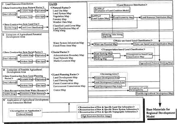
Figure 1: Flowchart for study process
- Information on Natural Factors
Information on natural factors stored to the database is graphic and attribute information of land systems maps compiled under FAO's Regional Physical Planning Program for Transmigration (RePPProT). Attribute information concerns meteorological, hydrological, edaphic, and geomorphological factors and is stored in the form of codified numbers. Also included is information on edaphic factors, river networks (1:50,000 scale topographic map), and flood damage in and around Jorong District. Water system and land user (11 categories classified by supervised classification methodology) information was interpreted from remotely sensed data (LANDSAT TM image) based on topographic maps (1:50,000 scale) and digitized data thus obtained on river networks, lakes, and wetlands.
- Information on Social Factors
The IAID included road network and market location information as social factors. Attribute information concerns the roads surveyed, type of road, surface condition and road width. Separate coverage were created by digitizing the administration boundary map, national company and industry map, land allocation map, land owner map, land development map, land use map, village locality map, and land system map. Village location information and economic conditions information were obtained from the local survey and farm household survey, respectively.
- Information on Land Suitability Conditions
Information on land suitability conditions included to the database was obtained by considering the cultivating requirements of the six major crops of the Jorong test area. The land suitability evaluation utilized the mathematical expression of the model for land use (derived from 11 land attributed information) as described in the RePPProt report.
- Extraction of Agricultural Potential Ranking Map
The evaluation led the compilation of latest water system information map derived from the satellite image, topographic map, irrigation ranking map, water use potential map, and water-use-based land classification map. Finally, the agricultural potential ranking was evaluated from water-use-based land classification map and transportation-based land classification map. The results indicated that the lowest ranked areas shown on the water-use-based land classification map was considerably dispersed due to social factors. The evaluation also revealed that Jorong District had concentrations of low ranking areas and did not have any well developed transportation network. It is believed, however, that since the map has been compiled through the land suitability evaluation using information on rivers that would not dry up during the dry season, the result obtained from the evaluation are not affected by seasonal variation of water availability. The high-ranking areas, therefore, are geographical areas suitable for agricultural development, and low-ranking areas can be made into areas suitable for agricultural development by providing facilities such as irrigation, water storage, and road facilities. The compiled agricultural potential ranking map clearly indicated areas where agricultural development of the wasteland would be expensive.
- Possible Agricultural Development Areas
The IAID utilized screening technique to identify areas which are free from any type of restriction on agricultural development and which can be developed as agricultural land. The screening of protected (specifically for the forested areas) and planning areas based on comprehensive IAID, agricultural potential areas considering long-term plans and areas suitable for development of transmigration villages dependent on mixed-field agricultural, were extracted.
Conclusions
The IAID is led to the evaluation of the Land Condition Model and compilation of the Land Resource Distribution and Agricultural Potential Ranking Maps. Agricultural Potential areas were successfully identified by screening the protected and planning areas and the topographic analysis resulted the extraction of possible agricultural development areas. Possible Agricultural Development Map, which is the end result of this study, shows areas suitable for agricultural development where transmigration villages dependent on mixed-field agriculture can be established. It is understood that the map will serve as a basis for basic data for deciding on such factors as primary crops, water facility development, road development, and land developability, i.e., as comprehensive basic database for formulation of regional development models.
Further study will include the precise information through high resolution latest satellite image is relation to the dry/wet season data, recompilation of the alang-alang distribution, reconstruction of topographic information, land suitability evaluation using economic factors and preparation of the technical manual for application of agricultural development area extraction method. The IAID is expected to promote the formulation of regional development models for new settlement plans, which consists primarily of redevelopment of the alang-alang covered wasteland in Tanahlaut, South Kalimantan, thereby contributing to conservation of tropical forests and improvement of agricultural production and rural life.
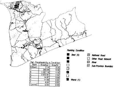
Figure 2: Possible Agricultural Development Map
Acknowledgements
The authors would like to express their sincere thanks to the South Kalimantan offices and the Tanahlaut offices of the Ministry of Transmigration and Forest Squatter and Resettlement, the Development Planning Board, the Land Tenure Agency, and the Ministry of Public Works for their assistance during the study. Also, thanks to Mr. Ajar Adhikary for his continuous dedication for processing the data.
References
- ADB, 1991. Remote Sensing and GIS for Natural Resource Management, ADB Environment Paper No. 1991.
- JICA, 1990. Japan International Cooperation Agency, Technical Manual for the Remote Sensing Engineering Project II for the Development of the Agricultural Infrastructure in Indonesia, February 1990.
- Miewald, T. and Narumalani, S. 1995. Geographical Information Analysis of the Agriculture Potential Among the Omaha Indians, GIS/LIS '95, Proceedings (2), 740-746.
- K. Sato, T. Suhama, M. Shizukuishi, M. Kanayama, Suitability Evaluation for Agricultural Development utilizing LANDSAT/TM Data, 1996. Proceedings of the 21th Japanese Conference on Remote Sensing, 127-128.