| GISdevelopment.net ---> AARS ---> ACRS 1996 ---> Water Resources / Hydrology |
The Effect of Rainfall Echoes
on Sar Image
Nobuhiko
Kodaria
Remote Sensing Technology Center of Japan
1-9-9 Reppong Minatoku, Tokyo 106, Japan
Abstract Remote Sensing Technology Center of Japan
1-9-9 Reppong Minatoku, Tokyo 106, Japan
One of the remarkable feature of Synthetic Aperture Radar (SAR) is its all weather capability, inn tropical region spaceborne optical sensor occasionally cannot observe a specified area over an year or more by the cloud cover, instead SAR can make observation weather independently through cloud. On the other hand, meteorological radar can detect rainfall images by the same radio waves or C-band or X-band. Most of the meteorological radar in Japan are operated by C-band. In this paper, back scattered echoes from rainfall are compared with natural ground echoes at C and band SAR.
1. Reflectivity factor Z of rainfall.
Rainfall target consists of great many water drops with various size distribution, and their fall speed differs each other by their size, it means that the rain drop distribution in the radar back scatter volume will change pulse to pulse by some degree. So that the Doppler sharpening for the azimuth compression becomes difficult to some extent. Synthetic aperture length for the meteorological target will extent, Synthetic aperture length for the meteorological target will depend on the phase variation between pulses and the phase different of p/4 will limit the maximum synthetic aperture length.
In case of Shuttle Imaging Radar SIR-C/X-SAR and meteorological target azimuth compression does not work perfectly because of the target phase will chance more than p/4 during the radar travels along synthesized length of the orbit. Azimuth resolution without compression for SIR-C/X is about 1.15 km, but the meteorological target of rainstorm is usually large enough to observe its pattern and intensity by this resolution. Echo intensity will increase as the increase of the azimuth resolution, but the azimuth improvement factor will decrease down by the amount of synthetic aperture length.
Echo volume consists of range resolution XR, azimuth resolution X, and height H, which extends up to 10 km in case of tropical convective storms.
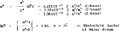
The rainfall rate R (mm/hr) is empirically related to the reflectivity factor Z (mm6/m3) by
In this equation;
D: raindrop diameter (mm), N: number of raindrops per unit volume,
R: rainfall rate (mm/hr).
The constants B and b appear to be a function of the type of storm such as thunderstorm, shower or Stratford rain. In an average B = 200 and b = 1.6 are proposed. (1) However, Z has a wide scattering aspect of about ± dB.
Reflectivity factor s0 is(3)
2.Calculation of reflectivity s.
For the calculation of reflectivity of meteorological target, rainfall height must be in consideration. Table 1 shows relations between R, Z, s and attenuation constant h. The ground surface echo intensity and rainfall echo intensity are compared in Fig. 1, where rainfall heights of 1 to 10 km are assumed for the case of the SIR C/X-SAR.
| R mm/hr | 1 | 10 | 100 | 400 |
| Z m6/m3 | 2x10² | 8x10³ | 3x10⁵ | 2.9x10⁶ |
| s dB/h (km) (L) | 1.9x10⁻⁸ | 7.4x10⁻⁷ | 2.8x10⁻⁵ | 2.7x10⁻⁴ |
| (C) | 15x10-6 | 2x10⁻⁴ | 7.6x10⁻³ | 7.2x10⁻² |
| (X) | 6.1x10⁻⁵ | 2.4x10⁻³ | 9.3x10⁻² | 9.1x10⁻¹ |
| h dB/km (L) | 0.0001 | 0.001 | 0.01 | 0.04 |
| (C) | 0.0031 | 0.031 | 0.31 | 1.24 |
| (X) | 0.013 | 0.18 | 2.6 | 12.8 |
| s: reflectivity, h:attenuation by rainfall h: height of rainfall | ||||
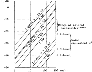
Figure 1 Radar reflectivity (s) vs. rainfall rate.
3. Compare of the surface target to rainfall s
Surface and rainfall s are compared in Fig.1, from this figure rainfall rate of about 20 mm/hr for X-band or about 100 mm/hr for C-band will become visible over the ground surface SAR image as bright patches. (h = r km)
Fig.2 shows an example of rainfall image of SAR taken at Satun, Thailand by X-SAR, incidence angle at image center is 61.3o and VV polarization. As the black shadow extends about is 10 km ensuing the rainfall echoes, rainfall echo top may be about 5 km.
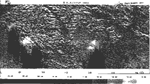
Figure 2 X-band rainfall echoes observed at Satun. Thailand.4
4. Attenuation by rainfall.
Several tenth of mm/hr of rainfall will significantly attenuate SAR radar wave by the amount shown in Table 1. Heavy rainfall will appear as a bright patch and ensuring radar echo will be attenuated under the noice level forming a dark shadow as shown in Fig. 3.
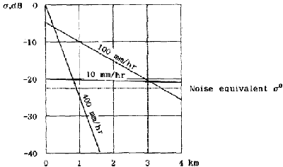
Penetration distance of radio wave through rain area. (two way)
Figure 3. Radar wave attenuation by the rainfall. (X-band) Noise equivalent s is the value for SIR-C/X-SAR The rainfall height is assumed to be 4.
5. Conclusion.
SAR is widely mentioned as weather independency and is deputed to be all weather capability to overcome optical sensors in the tropical area where in some cases optical sensor is very difficult to observe
However, in case of very heavy rainfall, X-band of SAR will receive echoes from rainfall especially in case of X-band. But there will be no echoes from rainfall for L-band SAR.
References
- Marshall. J.S. and W.M.Palmer, 1948: The distribution of raindrosp with size. Journal of Meteorology, 5, p.165.
- Cole,A.E. et al. 1969:Precipitation and clouds: A revision of Chapter 5, Handbook of Geophysics and Space Environments. AFCRL-69-0487.
- Kodaira.N. 1972: Fundamentals of Meterological Radar, Meteorological Research Note No. 112, Met. Society of Japan.
- Ake Reoseqvist, 1995: Forest monitorring by using synthetic apperture radar data. Regional R.S. Seminar on Tropical Ecosystem Management. Subic Philippines.
- Long, M.W., 1975: Radar reflectivity of land and sea. Artech House, Inc. 6. Shuttle Imaging Radar-C (SIR-C) JPL Publication 83-47, July 1983.
- Journal, R.L., B.L. Huneycut and M.Werner, 1995: The SIR -C/X-SAR Synthetic Aperture Radar System, IEEE Trans. of Geo. And Rem. Sen. Vol. 33, No. 4.