| GISdevelopment.net ---> AARS ---> ACRS 1996 ---> Water Resources / Hydrology |
Effect of Landuse Derivation
Strategies from Remote Sensing Data on Hydrologic Modeling
Srikantha
Herath1 and Dushmanta Dutta2
International Center for Disaster-mitigation Engineering
Institute of Industrial Science
University of Tokyo
7-22-1, Roppongi, Monato-ku, Tokyo 106, Japan
1Tel: 03-3402-6231(ext.2661) Fax: 033402-4165
Email : hearth@incede.iis.u-toktyo.ac.jp
2Tel:03-3402-6231(ext. 2663) Fax: 03-3402-4165
Email : dutta@incede.iis.u-tokyo.ac.jp
Abstract International Center for Disaster-mitigation Engineering
Institute of Industrial Science
University of Tokyo
7-22-1, Roppongi, Monato-ku, Tokyo 106, Japan
1Tel: 03-3402-6231(ext.2661) Fax: 033402-4165
Email : hearth@incede.iis.u-toktyo.ac.jp
2Tel:03-3402-6231(ext. 2663) Fax: 03-3402-4165
Email : dutta@incede.iis.u-tokyo.ac.jp
Distributed hydrologic models can be used to simulate hydorlogic processes in a catchment considering the spatial variability of catchment characteristics such as landuse, topography and other physical parameters. Remote sensing images provide a very effective means of estimating landuse parameters of a catchment as they can be used to estimate the temporal and spatial variation of a large area at high resolution. In this study the landuse of the Agno river basin in the Philippines was derived from SPOT satellite images using different landuse classification strategies, which include supervised, unsupervised and hierachical classifications. The best classification images ere judged by aerial photographs and site visits. The result show that there is a marked difference in the landuse categories that could be delineated from satelite image. Hydrological simulations were carried out with a distributed hydrologic model using different landuse maps obtained to identify the model sensitivity to the landuse maps. Results show different components of the hydrological cycle are affected to different degree depending on landuse information
1. Introduction
Hydrologic models are used to estimate the catchment response to the rainfall input. Mainly they are used to estimate river flows as a result of rainfall input to the catchment. Traditionally, the hydrologic models consisted of lumped models which represent the catchment and compute the discharge at a point. As the model parameters cannot be related to measurable catchment characteristics they require a long period of observations, both river flow and the rainfall, to calibrate the model parameters so that the model computations match the observed river discharges. However, in recent years, with increasing computational power at hand, it is becoming possible to use physically based catchment models to describe the hydrologic processes in the catchment. These models employ the governing equations of the water flow in its various phases, and simulate its movement through rainfall, evaporation, infiltration, subsurface flow, groundwater flow and river flow. Since there are no analytical solutions to any of the governing equations, coupled numerical models are used for the solution, which make it necessary to discretize the catchment into a number of grids, in the horizontal and vertical planes. Also due to the nature of the governing equation,s it is necessary to assume these ujits to be homogeneous in relation to some hydrologic properties, such as soil hydraulic characteristics. Therefore in order to set up a distributed hydrologic model, a large amount of distributed input should be prepared. Once such models are prepared they can be used to estimate not only the river flows at any point along the river, but also to estimate spatial distribution of other hydrologic variables such evapotranspiration, groundwater heads and soil moisture distribution. One important area of application of distributed models is the assessment of landuse change on the hydrologic regime.
Remote sensing data are an important source to estimate landuse paramenters effectively over large area at high resolution. They are attractive as means of obtaining temporal variation of landuse and to study its effect on hydrologic parameters. Therefore, it is important to identify the limitations of using satellite data in terms of sensitivity to the classification, especially such techniques are to be used in forecasting effects of landuse changes to the hydrologic techniques are to be used in forecasting effects of landuse changes to the hydrologic environment. In this paper, first we use SPOT image to derive a landuse map for a catchment under investigation, and then using the resulting landuse maps, we carry out hydrologic analysis to asses the sensitivity of these classification schemes.
2. Study Area
A sub catchment of the Agno river basin, the thrid larges river in the Philippines which lines in the western portion in the central part of Luzon island from 120o00' to 121o00'east longitude and from 15o00'to 16o00' north latitude with a drainage area 5.952 sq. km, is selected as the study are (National Water Resources Council, 1983). The sub catchment encompansses an area of 1,7000 sq. km and it is an ideal site for this study as both satellite images and data required for hydrological model simulation are available for the part of the basin (Fig.1). The annual average rainfall varies from 2,000 mm in the south-eastern part of the study area to more than 4,000 mm in the northern mountainous area.
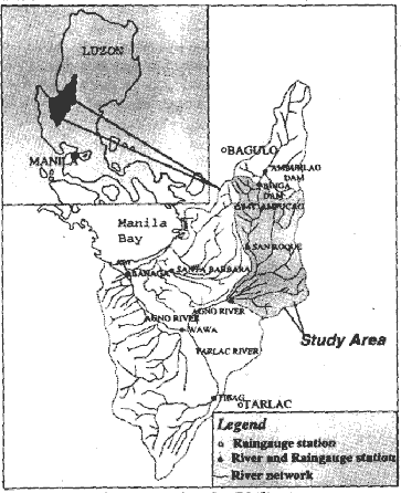
Figure 1 Agno River Basin, the Philippines
The study area can be distinctly divided into two parts based on the variation of landuse pattern i.e. the upper mountainous area and lower flat area. The includes dense and light forest areas, whereas, lower flat area is convered by agricultural fields and grass lands. In the lower part, along the Agno river, residential areas are visible.
3. Landuse Classification
3.1 Image selection
The SPOT HRV digital images are used for this study for landuse classification. The digital data was acquired for the study area for January 10, 1993, processed at the 1B level by SPOT Image Corp. This level of processing includes radiometric correction of variations in data that are caused by scanner malfunction and atmospheric interference. The imagery was acquired under excelled surface conditions. No precipitation had fallen during the preceding 20 days, and cloud cover on the image was negligible.
3.2. Geometric Correction
Geometric correction addresses problems associated with skew, rotation, and perspective in raw remotely sensed data (ERDAS, 1990). After importing the dataset to the proper digital format, was overlayed with the catchment boundary and river network data, digitized from 1:50,000 scale maps, to verify the geometric correctness of the dataset. Transformation and rectification of the image were done using the digitized river network for geometric correction of the dataset.
3.2 Classification
Supervised classification using the original bands and their subsequent transformations into NDVI (Normalized Difference Vegetation Index) and Soil Brightness Index (SBI) were performed to determine accuracy of identification of different landuse classes utilizing the satellite date (Table 1). The maximum likelihood and minimum distance classification algorithms were used in the classification.
| Transformed Indices |
| NDVI = (Infrared -Red) / (Infrared + Red) |
| SBI = (0.332 X Green) + (0.603 x Red) + 0.262 x Infrared) |
| (where, Green = band 1, Red =band2, and Infrared = band 3) |
Training area for supervised classification were taken from the aerial photographs available for the lower part of the study area, whereas for upper part of the basin, photographs taken during field visits were used to define the training areas. Training areas were selected uniformly for these classes. Supervised classification was performed using the selected training areas initially, for original three bands. However, the outcome was not satisfactory compared to the available ground truth data, and hence, further supervised classifications were conducted by changing the ratios of training areas and using additional bands i.e. NDVI and SBI. The resulting maps such as landuse compared with the aerial photographs as well as with the existing landuse maps such as landuse maps prepared by Swedish Space Corporation (SSC) in 1988 (Rasch, 1991). However, the outcomes from further supervised classifications were also not satisfactory for some classes to expected degree of accuracy. Hence, a more comprehensive approach was taken to classify the image using hierarchical statistical processing procedures (Baumgartner and Apel, 1996).
3.3 Hierarchical Statistical Processing Procedures
These procedures represent a more refined approach for classifying remote sensing data. Instead of processing all spectral bands with a large number of categories in one step, the number of spectral bands and categories is adapted to specific problems. Density slicing of each band was carried out to identify the range of reflectance values representing different classes and non-representative parameters were classified further using either supervised or by unsupervised learning techniques after extracting the representative parameters. Depending on the problem, several classifications - each resulting in a bit mask (thematic maps) - are carried out. After this multi-step classification, all the resulting bit masks are combined into final classification map.
3.4 Image Classification: Results and discussion
Based on the field data and prior knowledge of major distinct landuse patterns in the study area, a total of eight landuse classes were categorically selected as landuse types. They are; 1) Agriculture, 2) Grass land, 3) Bush and small branches of tree, 4) Forest, 5) bare/rocky land, 6) Builtup area, 7) Water body, and 8) Reservoir.
The results obtained from three supervised classification with different ratios of training areas and with additional bands (Table 2) show high variation of landuse classes agriculture, bared/rocky land and builtup area with the changes of total training areas and with the incorporation of additional bands. By comparing these classified landuse classes with ground truth data such as aerial photographs and field photographs, it can be clearly seen that few classes such as reservoir, water body and
forest are representative of actual field conditions, while a clear distinction between the other classes is not possible. Also, no definite trend could be found from the changing of area percentage of training area leading to a robust procedure to classify the image.
In the hierarchical statistical processing procedures (Fig.2), after, density slicing of these three bands, unsupervised classification was done using band 1, band 2 (>17), band 3 (<70), NDVI (<70%) and SBI for remaining five classes. From the classified image, only bare/rocky land class was visible as representative of actual class. Supervised classification was done for remaining classes using training areas based on ground truth information. The process was done many times modifying the training area ratios to obtain representative output. The final classified image shows that the three classes; agriculture, bush, and grass are well representative output. The final classified image shows builtup area takes some cells which represent agriculture area in reality. It may be due to similar reflectance of these areas as the image was taken in the month of January, which is not the cultivation season in the basin. Each resulting thematic map obtain in this whole process are combined into the final classification map (Fig. 3 and Fig. 4).
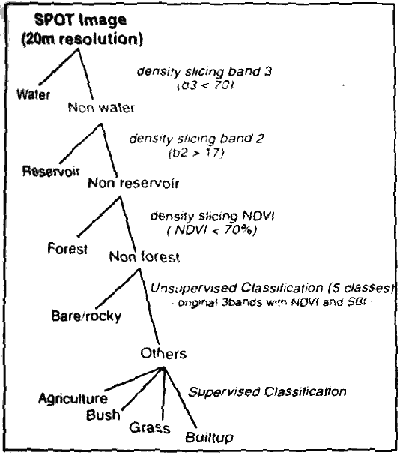
Figure 2 Dendrogram for a multi-step hierarchical, binary classification of SPOT Image
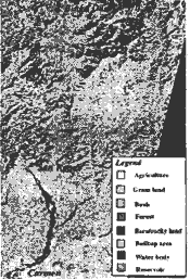
Figure 3 Classified Image from hierarchical statistical processing procedures
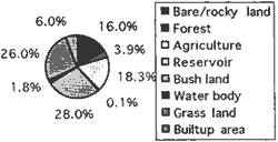
Figure 4 Percentage of different landuse classes
| Landuse Classes | Case I Original three bands | Case II Original three bands | Case III Original three bands | |||
| Area of Each class(Sq. Km) | Training Area(Sq. Km) | Area of Each class(Sq. Km) | Training Area(Sq. Km) | Area of Each class(Sq. Km) | Training Area(Sq. Km) | |
| Bare/ Rocky Land | 268.527 (6.7%) |
0.052 (0.6%) |
309.127 (7.8%) |
0.015 (0.1%) |
110.16 (2.8%) |
0.011 (0.1%) |
| Forest | 712.91 (17.9%) |
0.026 (0.3%) |
753.077 (18.9%) |
2.917 (27.3%) |
738.778 (18.5%) |
2.821 (27.3%) |
| Agricu- lture |
759.43 (19.0%) |
3.926 (46.3%) |
639.014 (16.0%) |
3.659 (34.2%) |
1009.77 (25.3%) |
3.579 (34.6%) |
| Reservoir | 7.145 (0.2%) |
0.55 (6.5%) |
7.382 (0.2%) |
0.517 (4.8%) |
7.054 (0.2%) |
0.506 (4.9%) |
| Bush land | 775.256 (19.4%) |
0.873 (10.3%) |
896.372 (22.5%) |
0.786 (7.4%) |
936.816 (23.5%) |
0.772 (7.5%) |
| Water body | 29.686 (0.7%) |
0.614 (7.2%) |
32.513 (0.8%) |
0.665 (6.2%) |
33.488 (0.8%) |
0.609 (5.9%) |
| Grass land | 813.975 (20.4%) |
2.244 (26.5%) |
842.042 (21.1%) |
2.079 (19.4%) |
909.535 (6.1%) |
2.038 (19.7%) |
| Builtup area | 619.987 (15.6%) |
0.188 (2.2%) |
507.391 (12.7%) |
0.052 (0.5%) |
241.316 (6.1%) |
0.014 (0.1%) |
| Total | 3986.916 (100.0%) |
8.473 (100.0%) |
3986.918 (100.0%) |
10.69 (100.0%) |
3986.917 (100.0%) |
10.35 (100.0%) |
4. Hydrologic Modeling
4.1 Methodology
A large amount of both spatial and temporal data are required to simulate hydrologic processes using distributed hydrologic model including details of landuse patterns of the study areas which govern evapotranspiration, infiltration and overland flow components in the hydrologic cycle. In this study, physically based distributed model SHE (Abbott et al., 1986) has been used to simulate the hydrologic processes in the Agno catchment. Required spatial and temporal data are collected from possible agencies in the Philippines and a GIS has been developed for spatial data to handle these extensive amount of data precisely (Dutta and Hearth, 1996). The drainage network was generated from the 50 m resolution digital elevation model (DEM) which was developed from digitized contours of 1:50,000 scale topography maps (Fig. 5).
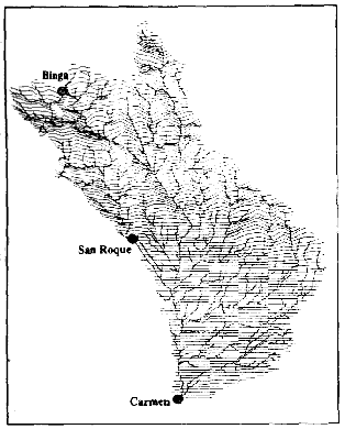
Figure 5 DEM of the study area (500m resolution) and generated river network
Five scenarious have been selected using the four different landuse maps obtained from the landuse classification and one from the existing landuse from SSC. The different classified landuse image were converted to grid data and resolution of the landuse maps were reset to model grid scale by aggregating the classes. The roughness coefficient, which governs the overland flow component in the model simulation for each landuse class is use to define the spatial variationof surface roughness in the entire study area.
Considering the availability of temporal data, time period for the model simulation is chosen as July 1 to August 20, 1989 which falls in rainy season and experienced a severe typhoon. Temporal variation of leaf area indices and root depth indices of various landuse classes are considered as input in the time series dataset in the model.
4.2 Hydrologic modeling : Results and Discussion
In all the different scenarios of model simulation, input data were kept same except landuse classes and its associated data such as surface roughness coefficients, time series of root depth and leaf area indices for different landuse patterns.
Table 4. shows the water balance for the simulation duration with the value for each component of hydrologic cycle for two cases. In Case I, one set of landuse parameters were used from SSC landuse information and in Case II, the landuse parameters obtained from the iamge classification by the hierarchical statistical processing procedures were used (Table 3). From the results of the two cases, it can be seen that simulation results are varying with different input landuse information. Same situation has been observed for other 3 cases also. From Table 4., it can be seen that both evaportranspiration and the surface runoff are significantly affected whereas moisture storage is affected to a lesser degree.
Thiscan be attributed to the direct dependency of evapotranspiration on leaf area index, which is related to landuse, and the dependency of overland flow on surface roughness which depends also on the landuse. On the other hand, as we did not alter the soil hydraulic property distribution, moisture storage is slightly affected. It should be noted that the differences are significant considering the short time period simulated, less than two months.
Table 3: Area statistics of various classes for case I and Case II
| classes (areas in sq. km.) | ||||||||
| No | Bare/ rocky land | Forest | Agricu- lture |
Reservoir | Bush land | Water body | Grass land | Builtup area |
| Case I | 238.2 (6.0%) |
175.0 (4.4%) |
1256.1 (31.5%) |
3.0 (0.1%) |
1299.8 (32.6%) |
74.3 (1.9%) |
923.5 (23.2%) |
16.7 (0.4%) |
| Case II | 637.1 (16.0%) |
154.6 (3.9%) |
3.0 (0.1%) |
3.0 (0.1%) |
1115.6 (28.0%) |
71.4 (1.8%) |
1037.8 (26.0%) |
238.5 (6.0%) |
| No. | Total Rainfall | Total Evaportran-spiration | Water stored in surface | Water stored in river | Accumu-lated net river flow | Unsatu-rated Zone storage | Water balance error |
| Case I | 8.30 | 154 | 22 | 11 | 15 | 637 | 10 |
| Case II | 830 | 127 | 26 | 11 | 17 | 656 | 9 |
| Case III | 17.5% | 18.2% | 0% | 13.33% | 3% | 1% |
5. Conclusion
Physically based hydrologic models are formulated based on the governing equations of difference hydrologic components and thus, expected to obtain better simulation results in any catchment independent of any specific basin characteristics. It needs precise input data to setup such models for simulation. From the results of model simulation in this study, impact of variation of landuse information on simulation results can seen very clearly. Especially, when distributed hydrologic modelsare used to assess the environmental impact of landuse change, the setting up of landuse information should be carried out carefully. As only remote sensing data provide a viable method to obtain these information, further research is needed for improved image classification algorithms.
References
- Abbott, M.B. Bathers, J.C., Cunge, J.A. O'Connel, P.E. & Rasmussen, J. (1986): An Introduction to the European Hydrologic System - Systeme Hydrologique Europeen, 'SHE', 1: History and Philosophy of a physically-based Distriubted Modelling System. Journal of Hydrology, Vol. 87, pp. 45-59.
- Baumgartner, M.F. and Apel, G.M. (1996): Remote sensing and geographic information systems, Hydrological Science Journal, 41 (4) August 1996.
- Dutta, D. and Herath, S. (1996): Development of a GIS for the hydrologic analysis of Agno river basin, the Philippines, Proceedings of Japan Society for Civil Engineering (JSCE) conference, 1996.
- ERDAS (1990): ERDAS Field Guide, Atlanta, GA, ERDAS Ind.
- National Water Resources Council (1983): Agno River Basins, National Water Resources Council Republic of the Philippines, Report no. 24-3B.
- Rasch, H (1990): Rapid Mapping of the Natural Conditions of the Philipines - A National Coverage in One Year -,Application of Remote Sensing in Asia and Oceania, Asian Association on Remote Sensing, 1991.
- Senseman, M et al. (1994): Spatial Analysis of SPOT HRV Digital Data for Measuring Landscape parameters of Prairie Dog Towns in Meade Country, Kansas, Geocarto International (2) 1994.