| GISdevelopment.net ---> AARS ---> ACRS 1996 ---> Application of RS and GIS to Land Degradation |
Soil erosion assessment and
its policy implications: A Case study of RS and GIS applications in Uthai
Thani, Thailand
Rajendra P. Shrestha1, Dr. Apisit Eiumonoh1 and Somchai Baimoung2
1STAR Program, AIT, P.O. Box 4, Khlong Luang 12120, Thailand
Tel: 66-2 5245584, Fax: 66-2-5245597,
Email : nrd48826@ait.ac.th
2Meteorological Department, Bangkok 10260, Thailand
Tel: 66-2 3931682, Fax: 66-2 3939409
Rajendra P. Shrestha1, Dr. Apisit Eiumonoh1 and Somchai Baimoung2
1STAR Program, AIT, P.O. Box 4, Khlong Luang 12120, Thailand
Tel: 66-2 5245584, Fax: 66-2-5245597,
Email : nrd48826@ait.ac.th
2Meteorological Department, Bangkok 10260, Thailand
Tel: 66-2 3931682, Fax: 66-2 3939409
Abstract
Soil erosion rate in Uthai Thani province of Thailand was assessed employing Universal Soil Loss Equation (USLE). Remote sensing and Geographic Information System (GIS) were used for the data interpretation and analysis, and analysis. The study identifies six erosion categories from hazard severity point of view in the study area. The estimated erosion rate rnages from 0 to 279.32 tons/ha/year and the upland area under sugarcane cultivation being most severe prone areas from the aspect of potential soil productivity. The study relates to the on-site physical effects of soil erosion in terms of soil loss, not take other factors, like soil erosion and crop productivity relationship; and off-site damage, in to account. The study recommends the need of long-range conservation measures to address the problem of soil degradation.
1. Introduciton
Of the world's land degradation problems, soil erosion is the first order category (Hitzhusen, 1993). Water and wind erosion account for the most land degradation on every continent except Australia. Available geologic records on erosion of different continents show that Asia has the highest erosion relate (74 ton/acre/yr) and the Australia has the lowest rate of 14 ton/acre/yr (El-Swaify, 1994). The fact that "soil erosion is the foreseeable result of poor or incorrect land use and that it can not be overcome unless and use and land management are improved" has generally not been appreciated (Sanders, 1992).
Many high priorities natural resource conservation projects throughout the world depend upon accurate erosion assessments and predictions (Onstand and young, 1988). Such assessments and predictions are rather important from agricultural production point of view as the soil is the basis of production. The need is not merely the quantifying the erosion rate but such outcome of erosion assessment by utilized in for policy formulation of maintaining the land productivity and the environment as a whole.
Universal Soil Loss Equation (USLE) is the most popular empirically based model used globally for erosion prediction and control. The major limitations of adopting quantitative 'western" models and convservation planning technologies to torpical regions need carefully valid site-specific data. This study attempts to quantify the soil loss, its spatial distribution an associated land use types in Uthai Thani province of Thailand, More importantly, the study aims to extend the realization of increased concern on the valuable soil resources that study aims to extend the realization of increased concern on the valuable soil resources that has to be protected from a sustainable agriculture point of view.
2. Methology
2.1 The study Area
The study area, Uthai Tahni province, is situated between 14o55' to 15o50'N and 99o05' to 100o 10'E in the western continental highlands of Thailand. The extreme high and low temperatures range from 16.6o C to 40.1oC with an annual rainfall of 1,139.2 mm. The cumulative rainfall of the months August to October constitutes more than half of the annual rainfall (Charuppat, 1992). The topography ranges from flat alluvial to undulating hills and mountains with an elevation of 14 to 1,554 m. a.s.l. Majority of the area falls under the soil order Ultisols. Besides forest, the major land use types include paddy, corn, cassavea. Sorghum and sugarcane. Except for sugarcane and mungbean, the areas under other corps have decreased on 1992/93 compared to 1981/82. Crop yield has declined for all the field crops.
2.2. Materials
Various existing secondary sources of information were used in this study which included : Landsat TM data acquired on 21 February 1995; Topographic map (1:50,000); Soil map (1:100,000); Land use map (1:250,000); is ohyetal map; published and unpublished exports, documents and literature.
2.3 Method
From USLE, soil loss is the function of six different factors as shown in the following equitation. The preparations of data for input to the equitation are discussed here under.
A=R*K*L*S*C*P
Where,
A= computed soil loss per unit area ( tons/ ha / yr)
R= Rainfall erosivity
K= Soil erodivility
L= Slope length
S= Slop steepness
C= Cover types
P= Management and Conservation practice
2.3.1 Determining the factor values
R- factor
R factor (rainfail erosivity) is the principal function of USLE Maximum rainfall intensity for 30 minutes (30) expressed as a kinetic energy of rainfall , is used to compute R factor as it is reported to have best correlation with the soil loss than the lower or the higher intensity. R is expressed in terms of annual erosivity in ton /ha/yr. In this study, the equation
R= 38.5+0.35r
where,
r = total rainfall amount in m.m.
as used by El-swaify et al (1985); Funnpheng et al (1993),was also used. Isohytal map ( based on 30 year's record) was used to delineate the different rainfall regimes in the study area. The computed values for different factors are presented in Table 1.
Table 1 Computed values for different factors
K-factor
K factor termed as soil erodibility is the integrated effect of processes that regulate rainfall acceptance and the resistance of the soil to particle detachment and subsequent transport. These processes are influenced by soil properties , of which soil texture is an important factor that influences erodibility. In Thailand, combine LS nomograph is however, available, it overestimates erosion rates on steep slopes. In this study soil erodibility was estinmated based on the characteristics of the soils using the following formula developed by Wischmeier and Smith, 1978 ( cited by Rainis, 1995).
100k = ( 2.1M1.4) 10 -4 ( 12-a ) + 3.25 (b-2) + 2.5 ( c-3)
where,
a = % of organic matter
b = soil structure class
c = soil permeability class
M= (% silt + % very fie sand) or ( 100- % clay)
L- factor
L factor which is the function of slope length along with the S factor ( slop steepness) represents the topographical factor commonly expressed as LS factor. Many researchers have used these two L and S factor as combined LS factor. Some of the researchers have also been found to consider the L and S factor as constant. In this study, L and S were computed separately. To establish the slope length, a Digital Elevation Model (DEM) was created in ERDAS and grouped in to four major classes of slope length with the help of overlaid drainage system. L factors for each slope length class were computed using with the help of overlaid drainage system. L factors for each slope length class were computed using the equation L =(meter/ 22.13)0.4 as used by Funnpheng et al, 1993.
S -factor
S factor termed as slope steepness factor is important in determining the velocity of the sediment runoff through water erosion. Since S factor is basically the function of the slope gradient, a conversion index developed in Thailand, was used to compute S factor for associated soil groups.
C and P - factor
C factor is the constant values for various land cover types and P factor is the constant values for management and conservation prractices. In the absence of separate information for these two factors, they wee treated as a single combind CP factor
2.3.2 Analytical methodology
Figure 1 persents the analytical methodology of the study. A digital image processing was performed to classify the Landsat TM data employing maximum likelihood classifier in supervised classification. Entire analysis was done done using GIS (PC ARC/INFO). The resultand soil loss rate clacualted from the analysis were further grouped in to six major groups to show the hazard severity in relation to the harzard severity in relation o the spatial distribution and their areal extent. Soil erosion rate with respect to land use types was calculated to difference the vulnerabl earea fromconservtionpoint of view.
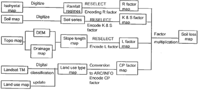
Figure 1. Analytical methodology for soil erosion assessment
3. Result and discussion
3.1 Estimating soil loss
Using USLE, two ways estimating erosion rates are found in practice. The fundamental diference is the factors taken in to consideration for computation of soiloss. The first one fermed as Potential erosion is computed based on ony four factors, viz. R..K.L and s whereas the second termed as Actual erosion. Since the latter type gives the real word pricture, soil loss through actual erosion is discussed below.
The Actual Erosion rate rnaged from 0 to 279.32 tons/ha/yr .For the land, minmum rate of soil erosion was as much as 0.04 ton/ha/yr.Maximum proportion (44.04%) of the total area of the province has slight erosion harard severity with less than 2.5 tons/ has soil loss annually (Table 2). The second class (31.30 % of the total area) interms of aral coverage is of moderatenture of hazard severity with 5 to (31.30% of the total area) in terms of areal coverage is of moderate nature of hazard severify with 5 to 10 tons soil loss/ha/yr following by slingh (14.82%), servere (9.46%) and very severe hazard severity (0.28%) with soil erosion ranging from 2.5-5,10-25 and 15-100 tons/ha/yr, respectively (Figure 2).
Table 2 Soil erosion classes and rating
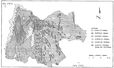
Figure 2 Soil erosion map of Uthai Thani, Thailand
3.2 Land use Vs soil loss rate
Determining the soil loss rate and associated land use types help in understanding the efforts needed to save the physical quality of the land that ultimately holds valuable information for developing necessary conservation strategies.
In this study, an absolute majority of the total soilloss can be attributed to the upland land use type, particularly sugarcane. An average rate of soil loss found for different land use types are presented in Table 3. The average soil loss from sugarcane area was 48.2 tons. From pady rice (3.01), from orchards (2.82) and from forest was 1.22 tons/ha/yr. On chan (1993) cited the similar findings of 0.02 to 0.2 tons/ha/yr soil loss from the forest and 10 to 100 from cultivated land, Similarly, Suddaprdea (1988) reported 4.5 -132 tons/ha/yr of soil loss for soil lossfor field crops and 2 -8 tons for forest.
Table 3. Average rate of soil loss for different land use types
3.3 Predicting soil productivity potential
In the quest of increased production, it has not been adequately realized that he soil resources are to be protected from being lost. The common experience of unsuccessful conservation techniques followed in the past indicates that inadequate understanding of developing the need oriented strategies. Hence, assuming at present rate of soil loss, an attempt was made to estimate the soil productivity potential period. The object is to develop realization of the need of long range planning for any soil conservation programs.
Since top 20 cm soil is regarded as the important layer for vegetation (particularly for the field crops), the value calculated was the years within which this layer will be completely wearied off. In Table e. paddy rice and orchards' land uses seem to have at quite satisfactory state as it will require 833 and 886 years for complete erosion. For the paddy fields, however, the erosion is expected to have moor minimal during cropping season, there is chance to have erosion during off season. In case of orchards, the surfaces soil, however, it not disturbed in most cases the computed erosion is basically due to erosive and Erodibillty factors. For forest area that is supposed to be in its natural state, calculated potential soil productivity was quite high (2,049 year). The most vulnerable situation is with the upland, basically under sugarcane. It was found out that at present state of erosion rate, incoming 52 years all the top layers will be eroded and the soil will be no more useful for crop production. Such fact sufficiently articulates the immediate and appropriate measures of soil conservation to be undertaken
4.Conclusions and Recommendation
This study exhibited that without considering other forms of land degradation, only water erosion causes a substaintail area to be eroded off in an insignificant time. Soil erosion is present in all land use types whether smaller or greater extent. To city a very simple example, in upland case, with an average soil N content of 0.22%, nearly 220 kgs. Of N/ a are washed -off annually which results in to many folds application N than being washed away as all of them applied are not available to the plants due to various reasons like leaching, soil nutrient imbalance, etc. Merely adding the higher level of nutrients is not the solution to the loss of crop productivity due to soil erosion. It depends upon the degree and extent of the top soil loss. Lal (1983) reported that no difference in the corn yield observed with and without fertilizer in 20 cm. Top layer eroded soil.
However, process of soil formation and degradation are continuously occurring in nature, immediate attention should be given for prescribing the adequate and proper conservation measures to protect the soil quality which is incomparably better than trying to restore the soil quality by replenishment which not only increase the production costs but also offsite environmental damage. Since land use types are most often influenced by government policy of earning national income which often leads to misutilization of land and eventually land degradation, Hence, proper care should be taken before implementing any policies that could lead to adverse effect.
Remote sensing and GIS can serve as valuable tools in assessing and monitoring the land degradation qualitiatively and qunantitvely as well which will help in developing appropriate and timely conservation strategies.
Soil erosion's location specific, its technical and economic attributes vary widely both within and between location. Oreover ,the USLE was originally developed for different aim within given specific situation, hence caution should be taken in extending the model to different domain.
References
Soil erosion rate in Uthai Thani province of Thailand was assessed employing Universal Soil Loss Equation (USLE). Remote sensing and Geographic Information System (GIS) were used for the data interpretation and analysis, and analysis. The study identifies six erosion categories from hazard severity point of view in the study area. The estimated erosion rate rnages from 0 to 279.32 tons/ha/year and the upland area under sugarcane cultivation being most severe prone areas from the aspect of potential soil productivity. The study relates to the on-site physical effects of soil erosion in terms of soil loss, not take other factors, like soil erosion and crop productivity relationship; and off-site damage, in to account. The study recommends the need of long-range conservation measures to address the problem of soil degradation.
1. Introduciton
Of the world's land degradation problems, soil erosion is the first order category (Hitzhusen, 1993). Water and wind erosion account for the most land degradation on every continent except Australia. Available geologic records on erosion of different continents show that Asia has the highest erosion relate (74 ton/acre/yr) and the Australia has the lowest rate of 14 ton/acre/yr (El-Swaify, 1994). The fact that "soil erosion is the foreseeable result of poor or incorrect land use and that it can not be overcome unless and use and land management are improved" has generally not been appreciated (Sanders, 1992).
Many high priorities natural resource conservation projects throughout the world depend upon accurate erosion assessments and predictions (Onstand and young, 1988). Such assessments and predictions are rather important from agricultural production point of view as the soil is the basis of production. The need is not merely the quantifying the erosion rate but such outcome of erosion assessment by utilized in for policy formulation of maintaining the land productivity and the environment as a whole.
Universal Soil Loss Equation (USLE) is the most popular empirically based model used globally for erosion prediction and control. The major limitations of adopting quantitative 'western" models and convservation planning technologies to torpical regions need carefully valid site-specific data. This study attempts to quantify the soil loss, its spatial distribution an associated land use types in Uthai Thani province of Thailand, More importantly, the study aims to extend the realization of increased concern on the valuable soil resources that study aims to extend the realization of increased concern on the valuable soil resources that has to be protected from a sustainable agriculture point of view.
2. Methology
2.1 The study Area
The study area, Uthai Tahni province, is situated between 14o55' to 15o50'N and 99o05' to 100o 10'E in the western continental highlands of Thailand. The extreme high and low temperatures range from 16.6o C to 40.1oC with an annual rainfall of 1,139.2 mm. The cumulative rainfall of the months August to October constitutes more than half of the annual rainfall (Charuppat, 1992). The topography ranges from flat alluvial to undulating hills and mountains with an elevation of 14 to 1,554 m. a.s.l. Majority of the area falls under the soil order Ultisols. Besides forest, the major land use types include paddy, corn, cassavea. Sorghum and sugarcane. Except for sugarcane and mungbean, the areas under other corps have decreased on 1992/93 compared to 1981/82. Crop yield has declined for all the field crops.
2.2. Materials
Various existing secondary sources of information were used in this study which included : Landsat TM data acquired on 21 February 1995; Topographic map (1:50,000); Soil map (1:100,000); Land use map (1:250,000); is ohyetal map; published and unpublished exports, documents and literature.
2.3 Method
From USLE, soil loss is the function of six different factors as shown in the following equitation. The preparations of data for input to the equitation are discussed here under.
Where,
A= computed soil loss per unit area ( tons/ ha / yr)
R= Rainfall erosivity
K= Soil erodivility
L= Slope length
S= Slop steepness
C= Cover types
P= Management and Conservation practice
2.3.1 Determining the factor values
R- factor
R factor (rainfail erosivity) is the principal function of USLE Maximum rainfall intensity for 30 minutes (30) expressed as a kinetic energy of rainfall , is used to compute R factor as it is reported to have best correlation with the soil loss than the lower or the higher intensity. R is expressed in terms of annual erosivity in ton /ha/yr. In this study, the equation
R= 38.5+0.35r
where,
r = total rainfall amount in m.m.
as used by El-swaify et al (1985); Funnpheng et al (1993),was also used. Isohytal map ( based on 30 year's record) was used to delineate the different rainfall regimes in the study area. The computed values for different factors are presented in Table 1.
| |||||||||||||||||||||||||||
K-factor
K factor termed as soil erodibility is the integrated effect of processes that regulate rainfall acceptance and the resistance of the soil to particle detachment and subsequent transport. These processes are influenced by soil properties , of which soil texture is an important factor that influences erodibility. In Thailand, combine LS nomograph is however, available, it overestimates erosion rates on steep slopes. In this study soil erodibility was estinmated based on the characteristics of the soils using the following formula developed by Wischmeier and Smith, 1978 ( cited by Rainis, 1995).
where,
a = % of organic matter
b = soil structure class
c = soil permeability class
M= (% silt + % very fie sand) or ( 100- % clay)
L- factor
L factor which is the function of slope length along with the S factor ( slop steepness) represents the topographical factor commonly expressed as LS factor. Many researchers have used these two L and S factor as combined LS factor. Some of the researchers have also been found to consider the L and S factor as constant. In this study, L and S were computed separately. To establish the slope length, a Digital Elevation Model (DEM) was created in ERDAS and grouped in to four major classes of slope length with the help of overlaid drainage system. L factors for each slope length class were computed using with the help of overlaid drainage system. L factors for each slope length class were computed using the equation L =(meter/ 22.13)0.4 as used by Funnpheng et al, 1993.
S -factor
S factor termed as slope steepness factor is important in determining the velocity of the sediment runoff through water erosion. Since S factor is basically the function of the slope gradient, a conversion index developed in Thailand, was used to compute S factor for associated soil groups.
C and P - factor
C factor is the constant values for various land cover types and P factor is the constant values for management and conservation prractices. In the absence of separate information for these two factors, they wee treated as a single combind CP factor
2.3.2 Analytical methodology
Figure 1 persents the analytical methodology of the study. A digital image processing was performed to classify the Landsat TM data employing maximum likelihood classifier in supervised classification. Entire analysis was done done using GIS (PC ARC/INFO). The resultand soil loss rate clacualted from the analysis were further grouped in to six major groups to show the hazard severity in relation to the harzard severity in relation o the spatial distribution and their areal extent. Soil erosion rate with respect to land use types was calculated to difference the vulnerabl earea fromconservtionpoint of view.
Figure 1. Analytical methodology for soil erosion assessment
3. Result and discussion
3.1 Estimating soil loss
Using USLE, two ways estimating erosion rates are found in practice. The fundamental diference is the factors taken in to consideration for computation of soiloss. The first one fermed as Potential erosion is computed based on ony four factors, viz. R..K.L and s whereas the second termed as Actual erosion. Since the latter type gives the real word pricture, soil loss through actual erosion is discussed below.
The Actual Erosion rate rnaged from 0 to 279.32 tons/ha/yr .For the land, minmum rate of soil erosion was as much as 0.04 ton/ha/yr.Maximum proportion (44.04%) of the total area of the province has slight erosion harard severity with less than 2.5 tons/ has soil loss annually (Table 2). The second class (31.30 % of the total area) interms of aral coverage is of moderatenture of hazard severity with 5 to (31.30% of the total area) in terms of areal coverage is of moderate nature of hazard severify with 5 to 10 tons soil loss/ha/yr following by slingh (14.82%), servere (9.46%) and very severe hazard severity (0.28%) with soil erosion ranging from 2.5-5,10-25 and 15-100 tons/ha/yr, respectively (Figure 2).
| class | Rating (ton/ha/yr) | Area (ha) | Hazard severity | % |
| 1 2 3 4 5 6 |
<2.5 2.5-5.0 5.0-10.0 10.0-25.0 25.0-100.0 >100.0 |
292,005.83 98,298.85 209,174.71 62,732.21 1,863.11 714.22 |
Very
slight Slight Moderate Severe Very severe Extremely severe |
44.04 14.82 31.30 9.46 0.28 0.10 |
| Total | 662,925.82 | 100.0 |
Figure 2 Soil erosion map of Uthai Thani, Thailand
3.2 Land use Vs soil loss rate
Determining the soil loss rate and associated land use types help in understanding the efforts needed to save the physical quality of the land that ultimately holds valuable information for developing necessary conservation strategies.
In this study, an absolute majority of the total soilloss can be attributed to the upland land use type, particularly sugarcane. An average rate of soil loss found for different land use types are presented in Table 3. The average soil loss from sugarcane area was 48.2 tons. From pady rice (3.01), from orchards (2.82) and from forest was 1.22 tons/ha/yr. On chan (1993) cited the similar findings of 0.02 to 0.2 tons/ha/yr soil loss from the forest and 10 to 100 from cultivated land, Similarly, Suddaprdea (1988) reported 4.5 -132 tons/ha/yr of soil loss for soil lossfor field crops and 2 -8 tons for forest.
| Land use types | Total area | Average rate of soil loss (ton/ha/yr) | Pointier soil productivity (yr) | |
| ha | % | |||
| Paddy
rice Sugarcane Orchards Forest Waterbody |
130,366.7 151,883.5 21,992.3 359,855.1 990.7 |
19.6 22.9 3.3 54.1 0.1 |
3.01 48.20 2.82 1.22 0.00 |
8.33 52 886 2,049 |
| Total | 665,088.5 | 100 | ||
| Note: 1 cu. Cm top soil = 1.25 gm (hurni, 1988) | ||||
3.3 Predicting soil productivity potential
In the quest of increased production, it has not been adequately realized that he soil resources are to be protected from being lost. The common experience of unsuccessful conservation techniques followed in the past indicates that inadequate understanding of developing the need oriented strategies. Hence, assuming at present rate of soil loss, an attempt was made to estimate the soil productivity potential period. The object is to develop realization of the need of long range planning for any soil conservation programs.
Since top 20 cm soil is regarded as the important layer for vegetation (particularly for the field crops), the value calculated was the years within which this layer will be completely wearied off. In Table e. paddy rice and orchards' land uses seem to have at quite satisfactory state as it will require 833 and 886 years for complete erosion. For the paddy fields, however, the erosion is expected to have moor minimal during cropping season, there is chance to have erosion during off season. In case of orchards, the surfaces soil, however, it not disturbed in most cases the computed erosion is basically due to erosive and Erodibillty factors. For forest area that is supposed to be in its natural state, calculated potential soil productivity was quite high (2,049 year). The most vulnerable situation is with the upland, basically under sugarcane. It was found out that at present state of erosion rate, incoming 52 years all the top layers will be eroded and the soil will be no more useful for crop production. Such fact sufficiently articulates the immediate and appropriate measures of soil conservation to be undertaken
4.Conclusions and Recommendation
This study exhibited that without considering other forms of land degradation, only water erosion causes a substaintail area to be eroded off in an insignificant time. Soil erosion is present in all land use types whether smaller or greater extent. To city a very simple example, in upland case, with an average soil N content of 0.22%, nearly 220 kgs. Of N/ a are washed -off annually which results in to many folds application N than being washed away as all of them applied are not available to the plants due to various reasons like leaching, soil nutrient imbalance, etc. Merely adding the higher level of nutrients is not the solution to the loss of crop productivity due to soil erosion. It depends upon the degree and extent of the top soil loss. Lal (1983) reported that no difference in the corn yield observed with and without fertilizer in 20 cm. Top layer eroded soil.
However, process of soil formation and degradation are continuously occurring in nature, immediate attention should be given for prescribing the adequate and proper conservation measures to protect the soil quality which is incomparably better than trying to restore the soil quality by replenishment which not only increase the production costs but also offsite environmental damage. Since land use types are most often influenced by government policy of earning national income which often leads to misutilization of land and eventually land degradation, Hence, proper care should be taken before implementing any policies that could lead to adverse effect.
Remote sensing and GIS can serve as valuable tools in assessing and monitoring the land degradation qualitiatively and qunantitvely as well which will help in developing appropriate and timely conservation strategies.
Soil erosion's location specific, its technical and economic attributes vary widely both within and between location. Oreover ,the USLE was originally developed for different aim within given specific situation, hence caution should be taken in extending the model to different domain.
References
- El-Seaify, S.A.W.C. Moldenhauer and A.Lo. 1985. Soil Erosion and Conservation. Soil Conservation Society of America, Ankeny, lowa.
- El-Seaify, S.A. 1994. State of Art of Assessing Soil and Water Conservation Needs and Technologies, In: Adopting Conservation the Farm: An International Perspective on the Socio-economics of Soil and Water Conservation, Soiland Water Conservation Society, lowa, USA, pp. 13-27.
- Funnpheng, P.,S. Patinavin, S. Mekpaiboonwattana and pP.Pramojanee. 1993. ILWIS Application for Soil Erosion Harzard Assessment Case Study Upper Pasak Catchment Lom Sak-Lom Kao District, Phetchabun Province, (manuscrpt)
- Hitzhusen, F.J. 1993. Land Degradation and Sustainability of Agricultural Growth: Some Economic Concepts and Evidence from Selected Developing Counties. In: Agriculture Ecosytems and Environment, Elsevier Science Publishers B.V. Amsterdam, Vol. 46, pp. 69-79.
- Hurni, Hans. 1988. Rainfall Direction and Its Relationship to Erosivity Soil Loss and Runoff, In: Land Conservation for Future Generations. Rimwanich, S. (editor), volume 1, Bangkok. Pp. 329-357.
- Lal R. 1983. Erosion Caused productivity Decline in soils of the Humid Tropics, In:Soil Taxonomy News. University of Hawalii, Honolulu, No. 5.
- Onchan, T. 1993. Land Use, Conservation and Sustainable Land Management in Asia. In: Rural Land use in the Asia and the Pacific, Asian Productivity Organization (APO), Tokyo.
- Onstad, C.A. and R.A. Young, 1988. System Analysis for Erosion Evaluation and Prediction. In: Land Conservation for Future Generations. Rimwanich, S. (editor), Volume 1, Bangkok.
- Rainis, R. 1985. The Effects of Slope Information From Several Geographic Inforamtion System (GIS) Softwares on Soil Erosion Estimates. Asian Pacific Remote Sensing Journal, Volume 7, No.2.
- Sanders, D.W. 1992. "Developing National and Regional Conservation Policies". In: Conservation Policies for Sustainable Hillslope Farming.Arsyad, S. et al (editors), Soil and water conservation society, pp. 3-13.
- Suddhapreda, N., E. P. Paningbatan Jr., W. Chakong and B. Piadong. 1988. Pridiction of Soil Erosion in Northern Thailand using a physical Model in: Land Conservation for Future Generations. Rimwanich, S. (editor), Volume 1, Bangkok, pp. 489-502.