| GISdevelopment.net ---> AARS ---> ACRS 1996 ---> Oceanography / Meteorology |
Investigation on Tidal Land
Reclamation in Korea Using Satellite Image Data
Kiyoshi Toril1,
Takashi Hoshi2, Takashi Kano3, Byung Jin
Cho4, Byung Ho Lim5, and Moon Soo
Choi2
1Dev. Of Environmental Sci. & Tech. Graduate School of Agriculture,
Kyoto Univ., Kitashirakawa, Sakyo, Kyoto, JAPAN
TEL & FAX In'l-81(0)75-753-6459,
E-mail toril@kais.kyoto-u.ac.jp
2Dept. Of Inform. Sci. Ibaraki Univ., Nakanarusaza-cho, Hitachi, JAPAN
3Tokyo Univ.of Fisheries, Konan, Minato-ku Tokyo, JAPNA
TEL. Int'l-81(03)-5463-073,
E-Mail http://www.gisdevelopment.net/aars/acrs/1996/ts7/kanotaka@tokyo-u-fish.ac.jp
4Det. Of Agric Eng., Gyensang nat. Uiv. Chinju, Korea
Tel. In'l-82-591-751-5433,
E Mail http://www.gisdevelopment.net/aars/acrs/1996/ts7/bjcho@gshp.gsnu.ac.kr
5Saemankeum Project office, Rural Development Corporation. Iri, Korea
Abstract1Dev. Of Environmental Sci. & Tech. Graduate School of Agriculture,
Kyoto Univ., Kitashirakawa, Sakyo, Kyoto, JAPAN
TEL & FAX In'l-81(0)75-753-6459,
E-mail toril@kais.kyoto-u.ac.jp
2Dept. Of Inform. Sci. Ibaraki Univ., Nakanarusaza-cho, Hitachi, JAPAN
3Tokyo Univ.of Fisheries, Konan, Minato-ku Tokyo, JAPNA
TEL. Int'l-81(03)-5463-073,
E-Mail http://www.gisdevelopment.net/aars/acrs/1996/ts7/kanotaka@tokyo-u-fish.ac.jp
4Det. Of Agric Eng., Gyensang nat. Uiv. Chinju, Korea
Tel. In'l-82-591-751-5433,
E Mail http://www.gisdevelopment.net/aars/acrs/1996/ts7/bjcho@gshp.gsnu.ac.kr
5Saemankeum Project office, Rural Development Corporation. Iri, Korea
In the west coast of Korean Penisula, facing the Yellow Sea, there exists a wide range of tidal differences between the low and high tides. As a result, the vast tracts of shallow tidal flats appears along the coastal lines during low tides. Such scale and compreshevsive tidal land reclamation projects have been underway since 1980s. It will take about fifteen more years to complete the project. In addition to the wide ranges of tidal differences and shallow fertile tidal flats exposed during the low tide, the given construction advantages such as plenty of construction materials nearby, scattered small island, Rias type coast lines and proper water resources have played important roles to boost such kinds of reclamation works. The purpose of the present study is to monitor, using satellite imagery, the sequence of changes that will occur including the land use and environment in the area with the progress of reclamation work. We focused on the two large scale projects, Yongsangang and Saemankeum. Using satellite image data, such as MOS-1, SPOT, Landsat TM, and JERS, we have been investigating how these projects are being developed and implemented. Some results of our preliminary investigation are discussed in this paper.
Introduction
In Korea, agricultural development meant construction of small-scale reservoirs, construction of pumping system providing irrigation water relatively easily and construction of intake weirs unil 1960. However, after such small-scale development had been implemented, supply of irrigation water to rainfed paddies in hilly lands, improvement of drainage in wet lowlands, farm land expansion by land reclamation have become the main projects of agricultural development. To carry out such a project, extremely advanced agricultural knowledge and engineering techniques are needed. In Korea, 72% of paddies have irrgation facilities. Agricultural development policy is also shifting from simple, small-scale agricultural development and land improvement to large-scale integrated regional development and land improvement to large-scale integated regional development work. For example, 12 projects have been conducted from 1970 to 1990. The total area of the projects has extended over 109,869 ha.
Newly reclamated farm land was 8567 ha and the mean project area was 9.156 ha. From 1990, 3 large-scale projects have been completed and their total area was 53,100 ha, which included 10,237 ha of newly developed farm land. The mean area of the 3 projects 17,00 ha, which is about twice he scale in the years before 1990.
Here, yangesangan integrated agricultural development project which is the largest project in the past and the gigantic project Saemankeum which was started several years ago are focused. This district was studied 3 years ago10 and ground truth was performed again this year. The projects in both areas were put into practice after careful examination and the and it may be dfficult to obtain new finding from satellite image data. However, by accumulating image data in time series.
1. Outlines of Yangsangan comprehensive agricultural development project
Yangasangan project is an integrated project for agricultural development and was started in 1972. The whole development process has been put into practice by upper into 5 districts. The integrated agricultural development in the first district, the upper stream of Yangsangan river, has been completed. The second district is the integrated agricultural development in the Yangasangan river mouth, which is in the final stage now. The third district is the enclosure of two gulfs, yangan Ho and Keum Ho and their desalination and water area reclamation and enclosure of the gulfs has been completed. Since Mogpo Estuary dam and the link canal of yangan ho lake have been completed, desalination of yangan Ho lake is progressing by introducing fresh water from Yangasangan rive to Yandgun Ho lake but the link canal to Keum Ho has not been completed. Construction of polder dikes, farm lands, irrigation canals and drainages system in the third district have not been started yet.
Outlines of these projects are as follows: construction of the enclosure dike of 4.35 km in length in the Yangasangan river mouth of the second district resulted in completion of Mogpo estuary dam, a desalted reservoir with a capacity of 253.3 million m3 and 6.872 ha of reclamation land. At the same time, land consolidation was implemented as well as the irrigation system with stable water resources and the agricultural basis of 4,899 ha was improved. This second district is near the end taking 16 years from 1976 to 1993. As a result, production of paddy rice and barley ahs improved enormously and the inland traffic net has been provided by utilizing the enclosure dike as a road. It has become possible to use 47 million m3 of water annually for industrial and urban uses.
In the adjacent third district, reclamation of tidal flat is in progress while desalting by closing yangan Ho and Keum Ho and introducing excess water in Mogpo Esuary dam in the second district by a direct link canal. The works in this district were started in 1987. The length of the enclosure dike for yangan Ho is 2.2 km while the water resources ha and the area of the agricultural land adjacent to the water area reclamation offered for improvement of irrigation and land consolidationis 6,730 ha.
The length of the enclosure dike for Keum Ho is 2.1 km and the water resources to be developed is 75 million m3, area of water land reclamation is 3,770 ha, and the area offered for improvement of irrigation and land consolidation in the adjacent agricultural lands is 3.030 ha. The enclosure dike is utilized as a road connection to the other side of the river, and is very useful in improving raffic situation in the districts in the tip of the peninula, the places which had been the isolation island with the land in old days peninsula, the places which been the isolated islands within the land in the old days.
1.1 Coming in and going out of fish through the locks.
Many fish go up a river from sea to return to sea from river mouth n certain season. This fishways are often attached to an enclosure dike as necessary facilities. However, it was confirmed that fish of a particular species rushed to the locks and went up the river in Yangasangan stage-3. The phenomenon was recorded by a vidgo-camera and television latter. The particular type of fish seemed to be attar ached because some water quality component (small) of the water flowing from upper stream spreaded over the sea surface when the locks were operated. Based on this experience, the locks are operated positively at appropriated Limes now to let particular types of fish go up the river of retrn in the area.
1.2 Cultivation of the drained land y by farmers
In Yangasangan projects Stage 3-1, the enclosing dike of Yangan Ho was completed in 1991 and the salt water in the bottom layer of the upstream desalted lake was drained by gate operation and desalting conduits. The link canal from Yangasangan estuary dam has also been completed permitting a gradual desalting of the lake and the mean salt concentration decreased to 1,700 ppm. A August 1996.The inside water level has been maintained lower than the outside water level(between 0.02 and -1.45)resulting in draining of all the lands which had once been tidal flats although polder dike, irrigation and drainage canals, or roads inside the area have not been touched officially yet. However, because the salt concentration decreased in the past 5 year and the lands which had been tidal flats were desalted by rainfall, the inhabitants in the vicinity of the area have consolidated the land arbitrarily without permission and started cultivation of rice and others by constructing irrigation canals. According to the field office, tempo ration farm lands consolidated by the inhabitants will be reconstructed once the official land consolidation and construction of drainage pump system and polder dikes these are started.
In Yangasangan Project Starge 3-2, the enclosing dike of Keum Ho was completed in 1993. Here drain bottom slat water and maintaining the inside water level lower than the outside have also operted. However the cancentration of Keum Ho Lake has Lake has not decreased below 17.000 ppm because only small river basin is providing fresh water flowing into the reservoir and the link canal to yangan Ho lank is incomplete.
The present state and future plan of Saemankeum comprehensive tideland reclamation project3)
This is the project which has been planned and put into practice regimentation experiences and results of the water area reclamation projects over several projects over several decades in the past to deal with land and water demands in recent years in Korea. The project plan prepared in 1989 was finally put into practice in 1991 after much meandering.
Fig. 1 Shows the conceptional drawing at completion. A period of 14 years is estimated for the whole project; 8 years for construction of water-use facilities including sea dikes and 6 years for construction of roads and bridges inside the drained land, establishment of irrigation and drainage canal networks and consolidation of land. The main facilities include the sea dike extending over 33 km, which is longer than the length, 32.5 km, of the enclosing dike for Zuyderzee, the Netherlands4), and 40,100 ha of land in total comprising 18,900ha of land for agriculture and fish cultivation, 11800 ha of desalted, reservoir, and 9,400 ha urban and industrial lands. Resort land for tourists and settlers acreage have also been integrated. Since lack of water is predicted if inflaming Mankyon river and Donjin river where the only water resources, construction of a 16-km link canal to Kumgang estuary dam being constructed in the north adjacent to the project area is planned to integrate excess water of some 450 million m3 to be developed for agriculture, industry urban life and resort project.
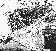
Figure 1 Land use plan of Saemankeum comprehensive tideland reclamation
On Gogunsan Islands off shore of the project area, construction of port facilities, resort facilities and new piers has been planned and construction of a railway connecting these facilities and Seoul passing thought the adjacent Kunsan city is coming within the range. Provided that this kind of social basis is developed in this project area, the area will play the role of an advance base building up the west coast era. Fig. 2 shows the state of progress of the construction works as far as 4.7 km of the section 1 of the enclosing dike in August, 1996. Construction of the drainage gate of Dongjin river is planned here.
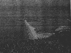
Figure 2 Radial gate will be constructed where joint place between section 1 and section 2 of closing dike.
2. Application of satellite image data
Fig. 3 shows the map of whole Korea. The large -scale projects mentioned above are developed in the areas including Mokpo and Kunsan. The 3 frames show the areas covered by the satellite images, shown Figs. 4,5 and 6, respectively. Table -1 shows he satellite image data of our possession applicable to these areas.
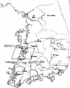
Figure 3 Total map of Korea and covering areas by SPOT-XS, SPOT-PN, and Landsat TM.
Table 1 List of Satellite Data applicable to Study areas
| No | Objective area mission | obs.data | pass-row | |
| 1 | Saemankeum | MOS-11993.02.02 | 29.70E | |
| 2 | Saemankeum | SPOT-XZ | 1993.10.08 | 304-278 |
| 3 | Saemankeum | SPOT-PN | 1993.08.23 | 304-278 |
| 4 | Yangasangan | Landsat-3 | 1979.07.05 | 124-36 |
| 5 | Yangasangan | MOS-1 | 1993.02.02 | 29-71E |
| 6 | Yangasangan | Landsat-TM | 1992.09.22 | D116-036 |
| 7 | Yangasangan | Landsat-TM | 1994.09.28 | D116-036 |
Fig.4 is the SPOT-XS image in the 2nd row of Table -1 showing the area measuring about 60km from east to west and 60 km from south to north. The upper-left river is Kungang river while the 2 central rivers are Mankyon river above and Dongjin river below both flowing into Saemankeum Gulf to be planned for a large-scale water area reclamation. Kimje plain forming the biggest granary in Korea is spreading in the center of the image. The town situated in the mouth of Kumgang river is Kunsan city, tht on its right is Iri city and that expanding in the piedmont is the Chonju city, the previous capital of province.
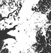
Figure 4 SPOT-XS '93.10.8 path-row 304-278 covering Kimje plain
Fig.5 is the SPOT-PN image shown in the 3rd row of Table-1. While it shows the same pass-row, the observation area is shifted to about 40kmto the west and 10 km to the south. It has the planned water area reclamation area on its top and the state of tidal project had started and the enclosing dike extending about 3 km in the north-west direction form the south can be seen.
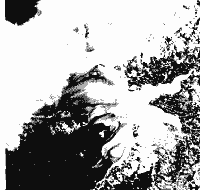
Figure 5 SPOT-PN '93.8.23 path-row 304-278 covering Saemankeum tideland
Fig.6. is the Landsat-TM image shown in the 6th row of Table -1. It shows 1/3 from the right edge and 2/3 from the upper edge of the whole image including about 50 km distance in the east-west direction and 120km in the north-south direction. Yangasangan river, the 4th biggest in Korea, is flowing in the center of the image and Mokpo city on the north bank of the river and the enclosing dike for Mokpo estuary dam in a little upperstream, Kwangju city having 1,000,000 population in the upper right of the image at the end fo Yangasanganriver can be seen. The works in the area from Kwangju city to Mokpo estuary dam have been implemented in the first stage of Yangsangan project and they are completed already. The area surrounding the estuary dam is the second area and, here, the project is almost compleed. Two inlets present on the south of the estuary dam are Yangan H and Keum Ho from the north. At the time of observation, construction of the enclosing dike in the former had been completed and its water level was about 1.40 m below the outside sea and the drained tidal flats are withened by salt educting on the ground. The enclosing dike for the latter is under construction showing the same state as in the old days.
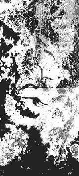
Figure 6 Landsat TM observed on '92.9.22 path-row D116-036 Yangsangan area
3. Concluding Remarks
We conducted field survey 2 or 3 times in the past. As mentioned above, the two large-scale tidal reclamation and freshingn reservoir projects were carefully examined and have been accomplished smoothly without serious troubles. They are not in the situation needing new information from satellite images. Blessed with natural environment of bit and shallow idal flats and wide range of tidal difference, integrated agricultural developments are apparently progressing rapidly. The satellite images here seem to be quite effective for explaining the state of progress of the projects. No adequate center measures to deal with changes in the river flows predicted after completion of the projects and in water circulation have been taken yet. These w projects progressing in the world now and we would like to observe these areas from now on by collecting data from earth observation satellites equipped with new functions in order to verify that they are effective methods for integrated regional development.
Finally, the satellite image data used n this study were kindly supplied from NASDA (National Space Development Agency of Japan) at special prices. Data processing was at special prices. Data processing was performed under the program development project of Kyoto University Data processing Center. We express our thanks to those concerned.
References
- Torii, K. et. al.: "Application to Satellite Image Data to Tideland Reclamation project in South west Coastal Zone of Korea", The 14th ACRS Tehran, Iran
- Rural Development Corporation, Annual Report 1991
- Saemankeum Comprehensive Tideland Reclamation Project, Ministry of Agriculture, Korea
- Torii, K., "Zuyder Zee Tideland Reclamation Project in the Netherlands" (in Japanese)