| GISdevelopment.net ---> AARS ---> ACRS 1996 ---> Oceanography / Meteorology |
Feasibility studies of
changes in Coastline, Sri Lanka
L.L.S. Roshani
Gunasekera.
Survey Department, Sri Lanka.
Introduction :Survey Department, Sri Lanka.
Sri Lanka coastal belt is subject to constant changes due to internal as well as external influences. For proper management of the coastal belt a continuing study of these changes is essential. Coast management is important for such activities as economics, development, tourism, planning research, science and education etc.
Firstly, this paper studies periodic changes that have taken place in Sri Lanka coast line.
Secondary, it depicts in statistical from the periodic changes in area where such changes are heaviest.
Thirdly, it indicates what technical steps need to taken for a proper study of the effects on coastal habitats due to changes in the coast lines. The content of this paper visualizes the periodic changes in the coast line and shows how a study of their influences on the coastal habitats could be undertaken with the criteria indicated.
Monitoring of coast line changes:
Here, a study in made of the comparative changes in the coast line by visual analysis of data with the help of maps prepared by Sri Lanka Survey Department. Maps on the scale of 1:500,000 prepared using one inch to one mile topographical mapping of 1924 -1960 period were utilized as the data source. 1:500, 000 scale maps subsequently prepared using 1983 Landsat imagery and the map of Sri Lanka based on IRS images of 1992 were thereafter used to compare the coast line variations. All these data have been compared by simple visual analysis the results of which is shown in figure 1.0
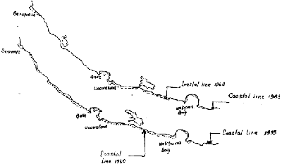
Figure 1
Thus a simple conclusion can be arrived at as what the changes in the coastal belt were during the 1960s, 1980s. In this analysis Weligama Bay area situated at Southern Coastal belt was selected for study as it was subject to comparable variations. Also some other coastal areas Unawatuna, Beruwala have changed, during the period.
The aerial photographs of 1:20,000 in 1983 and in 1965 were used for the purposes of further comparison and statistical presentation of the variation in the area. The results obtained are shown in figure 2.0
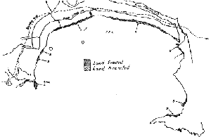
Figure 2
| Area No. | Area in Sq. meters |
| 1 | 1076 |
| 2 | 497 |
| 3 | 3591 |
| 4 | 30187 |
| 5 | 44188 |
| 6 | 2967 |
| 7 | 4306 |
| 8 | 7589 |
| 9 | 7344 |
Study of change of main coastal habitats:
As the third step, it necessary to study the changes in costal habitats in the areas which subjected to changes along the coastal belt.
The most common coastal habitats found in coastal area in Sri Lanka are:
1.Coaral reefs:
There are ecosystems situated in shallow tropical seas. The location of the major reefs are mappable from large scale aerial photographs.
2. Estuaries:
There are all river mouths into which the tide flow and the locations could be know from the available topographical maps.
4.Mangroves:
The area which covered by tree along sea coasts, lagoons and river mouths. The location of mangroves are mappable from aerial photographs, high resolution satellite imageries and field investigation.
5.Salt marshed:
It consists of herbaceous salt tolerant plant growing sandy or muddy coastal flat in arid area. The location could be known from the aerial photographs and topographical maps.
6. Seagram beds:
These are occurring in shallow, nearshore coastal water are consisting of communities of rooted seed bearing, marine plants. It is difficult to interpret from the small scale aerial photographs and location could be mappable from large scale aerial photographs.
7.Coatal sand dunes:
These are wind blown accumulations of sand occurring in the in the coastalizone. Their location and changes in position of major sand dunes are mappable from aerial photographs and topographical maps.
8.Barrier beaches and spits:
These are accumulations of unconsolidated sediment transported to shore by waves and molded into a form that lies across abode of water. Most of the beaches in Sri Lanka are barrier beaches by largoons. The locations of this are known from aerial photographs and satellite imageries.
9.Marsh lands:
These are permanently wet and muddy uncultivable and frequently inundated area. The location of marsh lands are mappable from aerial photographs, high resolution satellite image and topographical maps.
Black and white panchromatic aerial photographs can be made use of for the study of the main coastal habitats, but if it is the large scale aerial photography that facilitate more accurate conclusions.
The coastal habitats data thus identified by interpretation of aerial photographs can be compared with respect to different period of time.
For that study Kalametiya Kalapuwa and surrounding area was selected which situated along the Southern Coastal belt in Sri Lanka. About 1 Km inland area from the coastal line has been consider to study changes,
The aerial Photographs were taken in 1983/1993 and in 1965 are concerned for the interpretation. The said data has been converted in to 1:50,000 scale for the So, It can be noticed from that study major changes occurred in Kalametiya Kalapuwa. There was noticeable changes of marshy and mangroves areas during the period 1960's/1990's.
An initial conception of the variation can be study from the aerial photographs of selected area taken in 1980/1990 and in 1965. It will be necessary to map the data comparison. The results obtained was shown in figure 3.0.
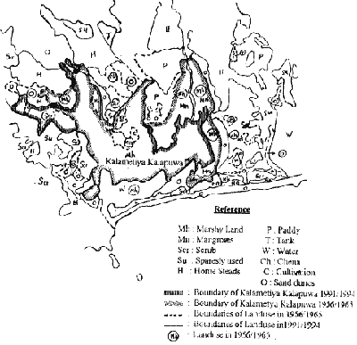
Figure 3
Absorbed and collated. For this purpose interpreted data should be incorporated to the scale of 1:50,000 to fit the existing topographical maps of the same scale.
It those mappable data can be structured in computer environment it is much easier and quicker to updata periodically. Hence the scientific approaches can be used for proper monitoring and planning.
Conclusions:
In this paper attempt was made to inquire as to what extent the existing Topographical Maps, Satellite images and aerial photographs available in Sri Lanka can be utilized for a study of the habitat changes utilized for a study of the habitat changes which have taken place in Sri Lanka coastal belt. Initially a pre-comparison is arrived at by means of small scale maps and satellite maps.
Next, the changes are presented statistically using medium scale aerial photographs, but is was done very approximately to get an idea for further analysis. The area changes idea ground control points could be calculated more precisely it need for further analysis. Also if the mappable changes occurred that these could be mapped and area calculation could be done on the map sheets in larger/medium scales. Determination of the scale depends on the purpose of the activity.
Finally, it was shown how a basic study of periodic changes in coastal habitats could be carried out the mapping the variations by means of aerial photographs, satellite imagery and existing maps. It was thus shown how the coastal changes taking place in our coastal belt could be subjected to a systematic study with the already available data and information.
Reference
- Remote Sensing Applications For Coastal Zone Management : By U.Samarasena (Survey Department, Sri Lanka)
- Remote Sensing Techniques to Coastal Studies and Environmental Monitoring in Sri Lanka : By K.Wisumperuma (Survey Department, Sri Lanka)