| GISdevelopment.net ---> AARS ---> ACRS 1996 ---> Mapping |
Semi-automated geometric
correction for mosaicing number of satellite data
Koki Iwao, Ryosuke
Shibasaki & Masataka TakagiI
Murai-Shibasaki Lab, Institute of industrial Science,
The University of Tokyo
7-22, Roppongi, Minato-ku, Toko 106, JAPAN
Tel . +81-3-3403-6231 EXT.2563
Fax. +81-3-3479-2762
E-mail: iwao@shunji.is.u-tokyo.ac.jp
Abstract :Murai-Shibasaki Lab, Institute of industrial Science,
The University of Tokyo
7-22, Roppongi, Minato-ku, Toko 106, JAPAN
Tel . +81-3-3403-6231 EXT.2563
Fax. +81-3-3479-2762
E-mail: iwao@shunji.is.u-tokyo.ac.jp
For continental scale land use/land cover study, generation of mosaic image from a large number of satellite images is indispensable. On board system adjustment is insufficient for making mosaiced image. Usually, we use GCP's (Ground Control Point) for high accuracy geometric correction, it is very labor demanding and difficult to find good GCP points in one scene for image coordinate registration. As such, we need to geometrically correct these satellite images at a stretch. In this paper, we propose a method to identify GCP's and tie-points in an automated manner, and to adjust geometric errors over all images based on the idea of block adjustment used in photogrammetry. With this method, we can improve the efficiency and reduce the total amount of GCPs required.
1.Introduction:
Since the South East Asia is a rapidly growing region the world, land use changes take place very drastically and cause a variety of serious environmental issues. Thus is requires more advanced management schemes of land use and environmental resources. We need information and tools to handle and analyze land cover / use change.
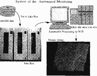
To get a good understanding of the changes that are taking place in the landuse and their effects on the local, regional and global scales, we need to have a complete database of the landuses - both past and present, to help us in analyzing the changes on the time scale. Above all, to adjust geometric errors are most important when we handle such a huge number of satellite data because on-board system adjustment is insufficient for making mosaiced image.
2. Methodology
A djust geometric errors overall images based on the idea of block adjustment It is not always easy to find GCP points clearly in one scene for image coordinate registration and geometric correction using GCP is very labor demanding. Further Traditional Geometric Correction Method can not effect on the surrounding satellite image coordinate that means if you can not find good GCP in one scene, you can not make mosaic image.
Therefore is necessary to correct geometrically of these satellite images automatically at one time. In this paper, we propose a method to identify GCP's and based on the idea of block adjustment used in photogrammetry. With this method, we can improve the efficiency and reduce the total amount of GCPs, required for geometric correction automatically. Process of this system are as follows.
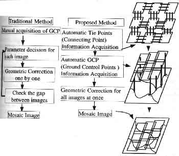
Fig. 1 Flow Chart of Geometric Correction
By comparing traditional method and proposed Method, we can say the merits of this system i.e.
- Less need manual Processing
- No need to check gaps between images
- We can manage less GCP images
3.1. Preprocessing:
Here, we used Landsat TM (1989, Jan-May). We used band 4 because this band can easily identify the water from the biomass.
3.2 Automated Acquisition of Tie Points
In the block adjustment method used in photogrammetry, tie point information is needed. Tie points are permanent information and we can get these data automatically. On the other hand, we have to develop efficient method in order to save the time.
Then we developed this method especially focused on quality and efficiency. (See Fig.2)
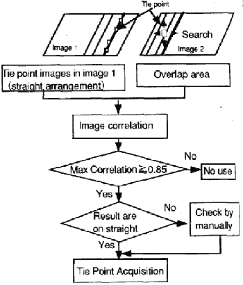
Figure 2 Flow of the Automated Acquisition of Tie Points
Tie point is the connecting (same location) point between two images. We used image correlation method used in stereo matching, because these images were acquired in different dates, and different solar angle etc. So with the method of sequential Similarity Detection Algorithm (SSDA) Method, we can not get good result, In order to check the quality and efficiency, we test the relation between template size, correlation function and calculating time.
We changed template size 7*7, 9*9, 11*11, 13*13, 15*15, 17*17, 19*19 and showed required time as 9*9 equal to 1. In 7*7 required time is good, but the quality is not much good. That is what we used 9*9 as a template size. (Graph.1) Next, we picked up 20 scenes randomly, and checked the difference between automated method and traditional (labor demanding) method.

Graph 1 Relation between template size, correlation function and calculating time
Graph 2 shows it's result. As a result, in tie point automated acquisition, we set 9*9 as a template size and correlation function more than 0.85.
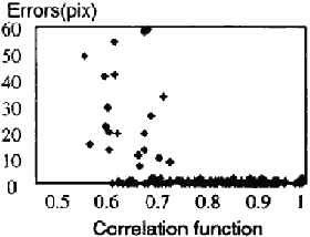
Graph 2 Difference between visual and automated tie point acquisition
3.3 Ground Control Point (GCP) Automated Acquisition
GCP acquisition is to give the location information to the satellite image using World Data Bank (WDB), Digital Chart of the World (DCW) and so on. In this process we use the information of coastal line or branch point of river because it is easy to identify in the satellite image. Here we used such water area's edge information for automated matching and giving location information.
To enhance water area in satellite images, we have five processes i.e.
- Make a Normalized Differential Vegetation Index (NDVI) image
- Detect edge of the water using level slice
- Edge enhance
- Remote Noise
- Thinning the edge
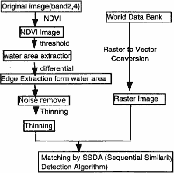
Figure 3 Flow of the Automated GCP Acquisition
Graph.3. Matching by SSDA (Sequential Similarity Detection Algorithm)
| RMSE | Max Error | Remark | |
| Coastal line | 1.3 | 3 Pixel | 3 case |
| Inland Wet land -little | 1.3 | 3 pixel | 5 case |
| Inland et land-many | 53 | 53 Pixel | 1 case |
4. Future works
- Make Time Series Mosaicking images around South-East Asia
- Land Use/Change Classification using Satellite Data
- Global GIS Data base development
- D.I.Barnea and H.F. Silverman, "A class of algorithms for Fast Digital Image Registration", IEEE Transaction on Computers, Vol. C-21, pp.179-186, 1972.
- W.F. Webber, "Tequniques for Image Registration' Proceedings of the IEEE Conference on Machine Processing or Remotely Sensed Data, pp. 1B-1 B-7, October 1973
- C.D. McGillem and M.Svedlow, "Digital Image Processing for Remote Sensing", IEEE press, p.p 168-173, 1978
- Keisuke Katsuta, "Block adjustment of Stereo Satellite imagery", proceedings of the 15th Asian Conference on Remote Sensing, pp. F-4-1-F-4-6, Vol. 1,1994.