| GISdevelopment.net ---> AARS ---> ACRS 1996 ---> Mapping |
A Topographic Database for
Geo-information Production Process in the Survey Department of Sri Lanka
Shyamalie Perera & K.D.
parakum Shantha
Survey General's Office, P.O. BOX 506
Colombo, Sri Lanka.
1.0 BackgroundSurvey General's Office, P.O. BOX 506
Colombo, Sri Lanka.
Since 1902, the Survey Department of Sri Lanka has been responsible for producing, large and small scale geo-information to its users. The small scale topographic information was produced to the users in the standard map forms in the users in the standard map forms in the scales of 1:63,360 and 1:50,000. New map series on 1:50,000 and 1:10,000 scale commenced in the year 1981 and 98% of 1:50,000 and 18% of 1:10,000 completed upto data. Although the data capturing is carried out using computer integrated photogrammetric equipments, the cartographic process and the printing of final maps are time consuming. For this reason it is not possible to provide the user with timely geo-information.
New technology development of hardware and multimedia software have given us the potentiality to add to the new functionality for he current system. This paper deals with the proposal for the establishment of a topographic database structure for the department in order to expedite the supply of geo-information to its diversified users.
More specifically the following topics will be discussed.
- the role and structure of the geo-information production process at present and proposals for the future.
- Design of a topographic database
- The functionality requirements (hardware/software/manware)
Survey Department is responsible for producing scales of 1:50,000 and 1:10,000 topographic information and thematic information such as Landuse. Presently, the department is supplied the geo-information in the form of conventional paper maps. These conventional map production and currently available information is summarized in table 1.9
2.1 Topographic Map Production
Main data capturing for topographic map production is based on aerial photographs using computer integrated photogrammetric equipments. The plotted map sheets are then to be sent for field verification. Checked and completed information is fed to the draugting section for cartographic work for map printing. The several units contribute in producing these maps. Figure 1.0 shows the present production line and staff involvement.
Considering the present situation of the 1:10,000 topographic mapping process out of 566 of the plotted manuscript 307 is in the standard map form. Data source of some of the plotted manuscript were 1984 aerial photographs and those have yet to be completed, it is difficult to provide timely geo-information to the users.
Table 1.0: Currently available information in the Survey Department
| Maps | No. of maps to cover the island | Commenced in | Completed | Completed up to data |
| 1:50,000 Topographic Maps | 92 | 1981 | 1996 | 98% |
| 1:10,000 Topographic Maps | 1834 | 1981 | 18% | |
| 1:100,000 Landue Maps | 24 | 1981 | 1990 | 100% |
Figure 1.0. The present statistics shows the flow of production is time consuming and depend on the work of the different work groups.
2.2 Landuse Map Production
Landuse patterns are extracted from aerial photographs by visual interpretation. The extracted features were compiled to the base of geometrically corrected LANDSAT MSS images. Compiled information were then checked and field verified. Afterthat, necessary cartographic work done in order to produce printed paper maps.
2.3 Limitaitions of the Conventional Maps in the Department
The conventional maps is the available media for storage and presentation of terrain features. Various symbols, line types, shapes, color and the map legend provide explanations and classification of map elements. Since the map is scale dependent, the acquired terrain features either with other related features, in order to present in a map form.
On the other hand, retrieval information from map and their combination with other surveys about specific properties of the earth's surface are neither easynor cheap nor cheap task. In addition to the cost and time required in the compilation and publication of printed maps, the systematic nature of conventional mapping programs can leads to delays in the development programs and in responding to urgent needs for topographic information.
When analyzing he present situation and the limitations of the conventional mapping procedures, it reflects that the line of production has to be reviewed and it is justifiable to introduce new concept for geo-information production within the department.
3.0 Way of Thinking
Digital technology was successfully introduced in the field of mapping in the late 1960's as means of speeding up map production and particularly the plotting and fair drawing phases. Changing technology in last two decades with the growing number of spatial information systems, the topographic database concept has been introduction in the several mapping and surveying organizations in the world in order to deliver more structural geo-information to the user community. Topographic database is a database which can store and update topographic information (spatial information) and relevant attributel information.
3.1 The Process of the Database design
The design of a topographic database in a GIS environment, involves various phases such as
- Identification an analysis of user requirements
- Design of the general data model
- Design of the data collection model
- Selection of the physical model
- Design of the functional model.
Studies of user needs are essential for the preparation of the conceptual and functional models of the system design. By user requirement analysis it is possible to ensure that its database neither has insufficient information nor redundant information. In the course of such studies the following items should be considered.
- Assessment of the present information status
- Tasks performed by topographic information users and geographic regions of interest for their activities
- Types of the queries asked by the users and nature of operations where topographic information are used.
- User preference for information content, classification, form of presentation, accuracy and resolution
- Type of data commonly used, map scales their sources and method of data collection
- Need for information not provided by standard products (eg., conventional maps)
Defining of data collection specifications should carried out in this phase. These specification reflects system context and user requirements. It involves establishment of standards implementation such requirements. It involves establishment of standards implementation such as method of data collection, methods of quality control and design of "quality model", specification for hardware/software support.. etc.
3.1.4 Physical Model
This is the database management system which could processes for data structure and data retrieving. For this processes, specification should provide definition for the characteristics of the required tools such as equipment, system calibration model and program packages.
3.1.5 Functional Model
This is he tailored data model which support the user's view on the stored data sets and their application. In this phase operations/commands which will operate on the data stored in the physical model into the form required by the users.
4.0 Implementation of the Topographic Database Concept
As the first step, organization should conclusively identify the user needs as described in para 3.1.1 In conceptual modeling their requirement placed in the situation existing in reality to be identified. After finalizing the database contents, data collection model have to be designed as discussed in para 3.1.3. There are well established data collection methods in the department namely photogrammetric process and land surveying. The majority of data collected by using computer upgraded trained staff. Hence, the present data collection by using computer upgraded photogrammetric equipments with the well collection procedures can be further operationalised. In the field completion stage, data completion and verification, quality assessment, collection of information for further clarifications and labeling have to be done. Well trained surveyors are available in the organization to perform this reality (e.g : administrative boundaries) to be obtained from existing information and to be collected by manual digitizing.
There is a growing acceptance of the use of the topological model for the conceptual modeling of topographic features and the number of well known data structures have been built around this conceptual modeling of topograpahic features and the number of well known data structures have been built around this concept , the ARC/INFO system is an example. As a physical data model, UNIX ARC/INFO version is available in the department. After describing topographic features by a set of topological elements (nodes, arcs and polygons) to be stored in a non-redundant manner. The partial relationships of connectivity and adjacency are explicitly expressed and included in the ARC/INFO data structure (arc-node, left-right, polygon-arc topologies) as data item themselves. Therefore, data structuring can be done in the available UNIX ARC/INFO software.
Spatial indexing to data contents is a major issue. ARC/INFO MAP LIBRARY system can handle large volume of datasets as well as its tile structure provides spatial indexing to its contents. Main and auxiliary indexing system to be prepared for external users.
At the stage of presentation of these information to he users, the map, i.e. the end product of the standard production line to be prepared. In that case, although computers are available for map designing, however, the capable software have to be decided. Additionally, the staff involved in map designing have to be trained on digital mapping. Map reproduction and printing could follow the present manual production line. Special products/derived products can be obtained through the database and information presentation forms are graphics, display, reports and digital files. The issues related in disseminating of digital files are not discussed in this paper. Graphic output devices such as flatbed plotter and drum plotters (CALCOMP) vector and raster) are also available to prepare the hardcopy outputs from the digital database.
Data storing and archiving is a major concern in topographic database systems. Therefore, the required hardware and software and software capabilities for data conversion and transferring as well as staff knowledge and skills also needed.
As such, with these available resources the concept could be tested in a pilot area. After gaining experiences from the pilot work evaluation reviewing of the procedures are required.
5.0 Conclusion
The Survey Department is the national Survey and Mapping organization and it is responsible to provide timely geo-information to users. Therefore, it is justifiable to introduce the proposed concept and that will be beneficial to the user community. A major advantage is that the user need not strict to the standard quality maps, they could obtain different form of information as they wish.
Today is difficult to strick to the conventional map production and hence a team of surveyor, photogrammetric technicals and draughtmen have to join together as a team rather than the conventional groups. Perhaps the new team of "geoinformatics" is the current approach in the production of topographic information for the future.
References
- Radwan M.M. -ITC Lecture Notes on Digital Mapping and Topographic Databases - 1990.
- Groot R. - Management Aspects of the Introduction of Spatial Information (SI) Technology in Mapping Organizations, ITC Journal, 1992-4.
- Erik De Man W.H. - Establishing a GIS in relation to its use, A process of Strategic Choices, International Journal of GIS, 1988, Volume 2, No. 3.
- Erik De Man W.H. Establishing a GIS as a form of Institution Building, A Quest for Redundancy, EGIS 1991.
- Tuori M. - A Topographical Map Conceptual Data Model, Spatial Data
Handing, Zurich, 1984, Volume.
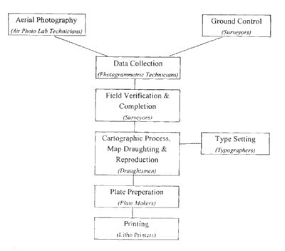
Figure 1.0 The current production line