| GISdevelopment.net ---> AARS ---> ACRS 1996 ---> Mapping |
A Comparison between ERS-1,
JERS-1, and Radarsat Satellite Radar Images for Mapping Tropical
Deforestation
Yourif Ali Hussin Belinda
Arunarwati Agus Wuryanta
The International Intitutue for Aerospace Survey
And Earth Sciences (ITC)
7500 AA Enschede, The Netherlands
Fax: (31)(53)4874-399
E-mail: HUSSING@ITC.NL
AbstractThe International Intitutue for Aerospace Survey
And Earth Sciences (ITC)
7500 AA Enschede, The Netherlands
Fax: (31)(53)4874-399
E-mail: HUSSING@ITC.NL
Forest resources are important socially, economically and environmentally, especially tropical forests which are the home to at least two-third of the world organism, a number that amount slightly close to 3 million species. Indonesia is one of countries having large tropical forests after Brazil and Zaire. The major part of the Indonesian land surface, i.e., 143 million ha (75%), has the status of forest land. For the management of this vast area, up to data information such as land use land cover change is important. Data on land cover change and land degradation processes are needed for land use planning and development of sustainable land use management. The extraction of information on land applications including land use mapping and monitoring. According to the international sustainable forest management for timber production. That is why there is an urgent need for data on actual tropical forest extent and land cover change. Since 1989, the Indonesian Government (i.e. Ministry of Forestry) ahs been doing an inventory of forest using aerial photography, Landsat and Spot satellite data. However, the current method largely failed to acquire data on yearly basis because of sever cloud cover. The main objective of this research work was to compare between the SAR images of ERS-1, JERS-1 and Radarsat satellite in mapping forest cover types in an area of Central Sumatra, Indonesia.
1.Introduction
It is generally recognized that forest resources should be sustainable managed to support the need of present and future generations. The capability of the land to produce in sustainable basis is, in one way or another affected by the different objectives of different people/actors. An illustration of these complex objectives are: farmers want to develop the area for food crops, loggers want to fell tree for timber, and environmentalist want conservation and protection. For these reasons, the problems on deforestation and environmental degradation as a results of the activities of the former actors (farmers and loggers) are become alarming.
Deforestation can be expressed by the rate of change of forest cove area caused by changing use of forest land. This leads to different causes of forest land change which could be an indication of different types of deforestation. In most cases, deforestation is caused by expansion of agricultural activities and other land use practices such the logging activity. According to the FAO, more than 80 percent of deforestation is attributed to agricultural expansion. Logging indirectly contributes to this major cause of deforestation by providing access to farmer through the constructions of timber extraction roads.
Indonesia, a part of Malaysian botanical region, is the richest rain forest in the world. The major part of Indonesian land has the status of forest land i.e. 143 million hectares or more than 75% of total land. To manage that forest land in sustainable way, the Government of Indonesia instigated the Consensus of Forest Land use or TGHK (Tata Guna Hutan Kesepakatan). The problem of condition is needed urgently to supply the decision makers' objectives in order to support the forest management of Indonesia.
Remote sensing is an important data source of spatial data. Remote sensing system are divided its active sensors (use their own energy), and passive sensors (use natural energy; sun energy). Radar is an active sensor which transmits and receive a microwave signal. Some advantages of the use of radar in remote sensing are: radar can be used during both day and night, all weather capability (cloud cover, rain, fog, atmospheric dust, etc.), and its energy have the ability to penetrate through some surgical features. Radar is expected to be used for a wide range of applications in forestry, such as: activities in forest management and surveillance, monitoring of deforestation, shifting cultivation, colonization settlements, and use change.
Nowadays, GIS is recognized as an important tool to analyze the spatial data. The objective of data analysis is to extract useful information to support the decision makers' objectives. Data from different sources should be combined and comprehensively analyzed to achieve a tangible result, problem due to complexities of different actors objectives over a certain piece of land is an indispensable aspect of monitoring and detection of the extent of deforestation.
Deforestation within classified area of TGHK may create some problem. Not very classified area of TGHK is allowed to be replaced by some other land use. For instance, the deforestation caused by conversion to rubber estate is not allowed within the protection forest, but it is allowed within the conversion forest. The problem due to the lack of useful information about deforestation make worst situation. Then, the need of reliable information about deforestation within different forest land use (TGHK), such as location, extent and types of deforestation, are becoming obviously important in order to monitor the deforestation occurring in relation to the TGHK.
Most of tropical countries use satellite imagery as a data source f their forest information. Landsat TM and SPOT satellite images are the important source. Problems due to lack of quality image as result of cloud cover occur in the tropical forest area like Sumatra island in Indonesia (Sumatra is notorious area for cloud cover. This problem can be solved with the use of radar images as data source. Several reference mention that radar had been used as an effective tool for detection the particular pattern of human activity such as logging, agriculture expansion, (shifting cultivation) and illegal settlement in the tropical forest which resulted to deforestation. The problem now is how to use the radar to overcome al of the former problem.
Geographical Information System (GIS) are computer based systems that are used and manipulate geographic information. Normally geographical data (location and their attributes) are very complicated, so the need to stable system to handle these data is crucial. For instance, to very complicated, so the need of stable system to handle these data is crucial. For instance, to integrate the radar data as one source of spatial data with the field data or other former information. GIS approach will be used to established methods to integrate and analyze that kind of spatial data. However, until recently, the application of GIS using input of radar data to monitor deforestation types within the classified area of TGHK might be considered is still in its early development. Types within the classified area of TGHK might be considered is still in its early development. Hence, contribution to this development through a series of research, becomes obviously important.
The main objectives of this research paper were: to investigation the possibility to detect, differentiate, and classify deforestation and its types using satellite radar data; to assess the accuracy of detection with the classified area of TGHK (Consensus of forest land use in Indonesia).
2. Material and Methods
2.1 Study area
The study are of this research is located in Jambi Province, between Jambi and Gunug Kerinci, new settlement and timber concession (System Gama Concession) areas in the east. The area is roughly 50 x 30 km in size, its latitude is between 1-2 degrees south and its longitude is between 101-103 degrees east. The forest (HP), Conversion Forest (HPK), and other Land Use (APL), then land cover of the study area are Unproductive dryland (lktp), Agriculture (Ptn), and Lowland forest (Hr).
2.2 Material Used
2.2.1 Remotely Sensed Data
The following remotely sensed data were used in this research: ERS-1 Synthetic Aperture Radar (SAR), Multi-temporal (4 image), data acquired on March 21, 1993, October 17, 1993, June 6, 1994, and July 7, 1994, in C-band (5.5 cm wavelength), 23 degree incidence and VV polarization; JERS-1 Synthetic Aperture Radar (SAR) of August 16, 1994, in L-band (23.5 cm wavelength), 35 degree incidence and HH polarization; Radarsat Synthetic Aperture Radar (SAR) image of August 17, 1996 is a C-band (5.6 cm wavelength), normal angel of 40 degree and HH polarization.
2.2.2 Other Ancillary Data
the following maps were used in this research: topographic map of study area at scale 1:50.000 and 1:250.000; Consensus of Forest Land Use map (TGHK map) of study area at scale 1:250.000; forest vegetation and land cover map of study area at scale 1:250.000; soil and agro-climatic zone map of study area at scale 1:200.000 or 1:250.000; transmigration and agriculture development area map at scale 1:200.000 or 1:250.000; and road network and drainage (river) map of study area at scale 1:50.000 or 1:250.000.
2.3 Methodology
The outline of the general methodology of the research is shown in Figure 1.
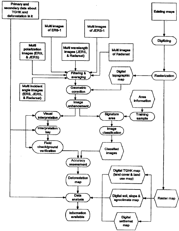
Figure 1 The general research methodology
2.3.1 Image Verification and Image Restoration
The removal of speckle noise can be attained by overlaying of several looks of the same area and averaging out the speckle values, or by the use of non linear filter such as the Lee filter , or Majority filter. Geometric correction is done using ground control points (GCP) from the digital topographic map or topographic map, or digital road network and river map as the master map and the radar imagery as the slave map. The minimum number of GCP are 4, more is better, and the sigma value should be less than 0.3.
2.3.2 Image Processing
The real processing of the image in this research are image enhancement, image classification and the accuracy assessment of the classify image. The image enhancement methods used were contrast manipulation (with contrast stretching; liner stretching and histogram equalization) and multi image manipulation (with principal component analysis). Before run classification, the signature area is indicated based on the various types of target and their appearance in the radar image, also some information about the research area (information from the orthophoto or another sources were used too). Then supervised classification was used. The accuracy assessment is expressed by performing the classification error matrix (confusion Matrix or contingency Table) and evaluating them.
2.3.3 Visual Interpretation and Samples Verification
The simple approach for classification of radar is to examine then visually, using a hard copy image. he visual interpretation was carried out based on tone/colour, texture, pattern, and association. The end result of the visual interpretation lead to the interpretation key. Then, the visual interpretation maps of radar images will be digitized, polygonized, and rasterized in 12,5 pixel size (or less) to get more information about the field situation and to establish the correlation between the classification and the real situation in the field, in the order to improve the accuracy of the interpretation and classification.
2.3.4 Geographic Information system (GIS) analysis
The information from remotely sensed data were to be integrated using GIS. Also it will integrate TGHK map, slope map. Soil type and agro-climatic map. GIS as a tool to overlay and analysis and other important about the study area.
Results
Because the authors just came back from the field work and still running the analysis, given the due data of submitting this manuscript, it was difficult to present results in this paper. However, hopefully during the conference, the authors will present s the results and a handouts to the conference attenders.