| GISdevelopment.net ---> AARS ---> ACRS 1996 ---> Land Use |
Monitoring of Land use
Changes
Ruklanthi
Silva
Center for Remote Sensing, Survey Department of Sri lanka
Abstract Center for Remote Sensing, Survey Department of Sri lanka
Landuse mapping was integrating visual interpretation of Aerial photographs & Satellite imagery commended with the production of Land use map on the scale of 1:100.000. The land is constantly changing due to various human activities, natural conditions and development activities. According to the User requirements, updating of the land use mapping is required at regular intervals. The objective of the study is to see the possibilities of applying the Satellite imagery in monitoring Land use changes more speedily.
In order to carryout this work, remotely sensed satellite Imagery in conjunction with other data sources (areal photographs & existing maps) has been used. ISR-LISS II satellite data were analyzed using PCI (Version 6.0) Software.
The use of remotely sensed satellite imagery provides a cost effective means to obtain useful land use data for large areas. In areas that are difficult to access this technique is perhaps a good method of obtaining the required data more effectively and speedily.
1.0 Introduction
Land use mapping of this country was first done in 1956, at the scale of 1:63,360. Then in 1980-90 period land use mapping was done at the scale of 1:100,000. This resulted in district base land use maps from the country. The experience gained through this mapping activity was mainly in the application of analogue techniques f compilation f map information.;
With increasing human settlement and land development, it is necessary to have an inventory of land resources of the country. The optimizing of land use for agriculture and for other purpose has been identified as a very important requirement for the achievement of economic and social benefit of the country. Therefore information will be classification and mapping of land use is an important task.
Remote sensing is a powerful technique for surveying, mapping and monitoring earth resources. This technique has become indispensable and increasingly more meaningful because of the synoptic coverage of satellites over large areas rendering its cost and time effectiveness. Furthermore, in areas that are difficult to access, this technique is perhaps the only method of obtaining the required data more affectivity and speedily.
2.0 Objective
The main objective of this study was to develop remote sensing methodology for monitoring land use changes to other areas using satellite data such as IRS II. Monitoring of land use/land cover changes which would help to plan development activities such as major schemes and for user requirements.
3.0 Study Area
The study area included within the administrative districts Ampara and Moneragala which falls in to Eastern and Uva provinces of Sri Lanka and covers an area about 800 km2. Its northern latitude is between 6° 30' to 6° 50' and Eastern longitude is between 81° 30' to 81° 50'. See Fig. 1.0 (Location of the study area). The area selected was mostly covered by forest. (75%).
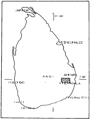
Figure 1.0 Location of the study area
4.0 Data Source Used
The following available data have been used in the analysis.
| Data | Data | Scale /Resolution |
| IRS LISS -II | March 1992 | 40m |
| Land Use Maps of Ampra & Moneragala | Aerial Photographs used in 1981-1984 | 1:100,000 |
| Topographic Map of Panama | 1987 | 1:50,000 |
5.0 Methodology
The outline of the general methodology is shown follows.
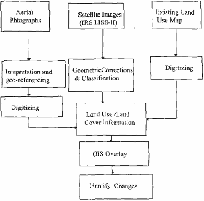
Figure 2.0
IRS-LISS II digital data used here is geocoded and radiometrically adjusted but was not colour enhanced. Spatial Resolution of IRS data is about 40m in pixel size.
Geometric Correction have been applied to georeference the raw image using the map. Linear enhancement technique with 2,3,4 band combination is used in this analysis. Enhanced the image using linear stretch based on the histogram and it has been transformed. Look up table was used to enhance 8 bit image data without actually modifying it by altering (remapping) image grey level before they are shown on the monitor. Enhancement serve to improve the contrast.
Land Use map of the study area was digitized using PC ARC /INFO. Then vector data was converted to raster format in order to use it with PCI software for further processing. See Fig. 2.0 Then it has been used to georeference the image.
Supervised classification was used in this analysis. First we selected the training sites and visually digitized it. The selection of training areas was based on spectral signature and spectral separability among classes. These training samples were used in the maximum likelihood classification. However, the result were not much discriminate landuse patterns when comparing it with prior information. It may be the similar spectral reflectance of landuse pattern in the study area.
Therefore, landuse pattern identification was performed by visual interpretation of the enhanced initial data. The visually interpreted landuse boundaries had been converted to vector format. The land use boundaries have to spline before overlaying it was existing landuse layer.
6.0 Results and conclusion
the study of Panama area was based on the analysis of satellite data. It shows the potential of detecting changes. Because of its high spatial resolution it was found to be quite helpful in extracting the requisite information for mapping land use/land cover.
A wide range of Land use/land cover categories and features like water bodies, river & lagoons, sand rocks, scrub land, built up area was identified through the semi automatic analysis of the satellite data. Based on the analysis land use changes can be detected comparing land use map.
If multitemporal data with high spectral and spatial resolution is available the better results can be obtained.
References
- PCI software, version 6.0 EASI/PACE, January 1, 1996, Volume I.