| GISdevelopment.net ---> AARS ---> ACRS 1996 ---> Land Use |
Assessing Land Use/Land Cover
Dynamics in Two Identified 'Hot Spot' Areas: Oudomxay Province of Lao
P.D.R. and Makong Delta of Vietnam
Chandra P. Gir1,
Eike kratzachmar2, Rey S. Oftren3, D.
Pradhan1 and Surendra
Shrshtha1
1UNEP Environement Assessment Programme for Asia and the pacific,
Asian Institute of Technology
P.O. Box 4, Klong Luong, Pathumathani 12120, Thailand
Tel: (66-2) 524-6236, Fax: (66-2) 516-2125,
E-mail: grid@cs.ait.ac.th
2Institute of cartography,
Drsden University of Technology, Dresden, Germany
3University of Auckland,
Auckland, New Zealand
Abstract1UNEP Environement Assessment Programme for Asia and the pacific,
Asian Institute of Technology
P.O. Box 4, Klong Luong, Pathumathani 12120, Thailand
Tel: (66-2) 524-6236, Fax: (66-2) 516-2125,
E-mail: grid@cs.ait.ac.th
2Institute of cartography,
Drsden University of Technology, Dresden, Germany
3University of Auckland,
Auckland, New Zealand
The macro-scale time series analysis of AVHRR data for Lao P.D.R and Vietnam identified two hot "hot spot" areas, one in Oudomxay province of Lao PD.R. and the other in Mekong Delta of Vietnam. Detailed investigation of these areas using high resolution satellite data supplemented by field survey revealed some interesting observations. In this paper some of the pertinent issues such as driving forces responsible for the changes, policy implications and further sceneries have been discussed for both the cases.
1.0 Introduction
UNEP Environment Assessment Programme for Asia and the Pacific (UNEP/EAP.AP) has been involving in the macro-scale assessment and monitoring ecologically important land cover types of selected countries in South and South East Asia. The principal goal of the land cover assessment and monitoring project is to prepare a wall-to-wall map of the major land cover types and monitor the changes across time. The time series analysis of coarse resolution satellite data such as NOAA AVHRR HRPT, identifies areas undergoing major land cover transformations, often termed as "hot spots" .Detailed investigation of these areas using high resolution satellite data such as SPOT, Landsat and IRS is needed for accurate and timely information pertaining the rate and phenomenon of change. It is also helpful in identifying driving forces responsible for the change (Giri & Shrestha , 1995).Such information can be useful for decision makers to formulate rational programs in land management and policy planning.
Multi-temporal analysis of AVHRR imagery consisting of 1985/86 and 1992/93 for the whole country of Iao P.DR. and Vietnam identified two "hot spot" areas, one in northern Laos and the other in Mekong Delta of Yitnam. Detailed investigation of these two areas were conducted using SPOT XS data. The approach, methodology and results have been discussed in this paper.
2.0 Study Area
A bried description of Oudomxay, Loss and Mekong Delta of Vietnam has been described below.
2.1 Oudomxay, Lao P.D.R.
The Study area encompasses considerable portion of Oudomxay province (Fig. 1). It is bounded between longitude 101o 14' 15" to 101o 56' 10" E and latitude 20o 12'38" to 20o 48' 47" N.
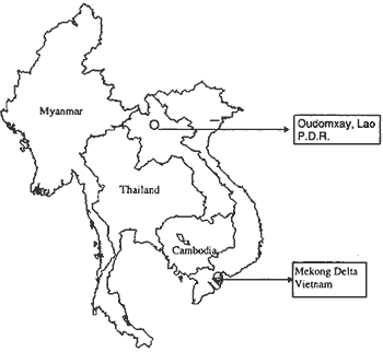
Figure 1 Approximate location of the study area
The study area is having a mountainous topography drained by two river systems, Nam Beng and nam. The greater part of the highland consists of an extensive rugged mountainous area which runs north to and is dissected with steep slopes and narrow valleys.
Oudomxay province has a population of about 291,000 persons in 1990 (Makong Secreatraiat, 1993). There major ethnic groups namely Lao Theung 55%), Lao Lum (31%) and Lao Sung (13%) are residing in the area. The main occupation of the population are farming and livestock raising. Shifting cultivatin remains the pre-dominant agriculture practice.
2.2 Mekong Delta, Vietnam
The study area is situated in the Southern part of Vietnam and bounded between latitude 9o 42' 43.92" and 10o 19' 27.87 N and longitude 106o 10' 1.35 E and 106o 51' 12.71" E. It is located about 25 km south-west of Ho Chi Minh City (Fig. 1).
Fig. 1 Approximate location of the study area The mainlandform types in the area include sand dunes, alluvial planins, fluvio-marine pains and denundatin slopes. The area is strongly influence by changes of the water level mainly because of its altitude and flat terrain. During July to November, about 75-80% of the annual total amount of surface water flows into the Sea (Hung and Luong, 1989).However, during January to April soils dry out very quickly and part of the study area suffers from drought.
The population density in the Mekong delta is 800 persons/sq. k, highest in the country (natons average is 179 person/sq.km). Villages in the study area have linear or radial patterns distributed above riverbank road and canals.
3.0 Data Basis
3.1 Oudoxay, Lao P.D.R.
SPOT XS data acquired on March 26, 1992 was used s the principal source of information Topographic maps and published information regarding land use/land cover practices were also used. At intensive field visit of four days was conduced on December 1994, approximately three months earlier the month of the acquisition of the satellite data. During the field trip, formal and informal interviews were take
With the government staff and local people. A part of the study area was visitd by establishing number of sample plots. In each sample plot, information on shifting coultivation, forest types, topography, slope and land use/land cover types were collected.
Villge map was digitized from 1:100,000 scale topographic map. Other information layers such as river, roads, elevation and geology were also used as a GIS layer in the analysis. These information were extracted primarily from the Digital Chart of the World (DCW).
3.2 Mekong Delta, Vietnam
SPOT XS data acquired on March 04, 1995 was used as the principal source of information of derive present status of land use/land cover in the study area. Other secondary information such as topographic maps, soil map, district and provincial boundary map, geological map, land use map, transportation network and work and canal Network map were collected from various sources and utilized in the data analysis.
An intensive field visit of six days was conduced in November, 1995, approximately three months earlier than the month of the satellite data acquisition. A representative sample of the study area were visited by establishing a number of temporary sample plots. In each sample plot, information on agricultural crops, cropping patterns, management regimes, dominant vegetation types, topography and soil types were collected Global Positioning System ()GPS) was used duplicates ample plots in the satellite imagery.
River and canals as well as land use maps were digitized from 1:100,000 scale topography map. Other data layers mentioned earlier, were available from UNEP/EAAP.AP and Mekong River Commission (MRC).
A common methodology was used for both the studies, as described below.
The SPOT image was spatially geo-referenced to a Universal Transverse Mercator (UTM) map projection using first order polynomial and reasampled with nearest neighbor algorithm. Ground Control Points (GCPs) were selected from 1:50,000 topographic map. A Root Mean Square (RMS) error of 1 pixel (20m) was accepted for rectification.
A hybrid approach of supervised and unsupervised classification was deployed. Isodata clustering followed by iterative labeling was used for unsupervised classification. Tanning areas was selected based on the field observation for supervised classification. The information from unsupervised classification was incorporated in the outcome of supervised classification. Supervised classification using maximum likelihood classifier in ERSAS (an image processing software) was performed by selecting a number of training samples. Statistical analysis of these training areas were performed to find out their consistency. The classified image was converted to vector format for further GIS analysis in ARC/INFO environment.
4.0 Results and Discussions
The present study cover a full scene of SPOT XS data having an area of approximately 36,000 sq k. Digital interpretation of SPOT XS data revealed eight major land use/land cover types in the study are. The following classes were selected and/or discerned from the satellite data used.
| (Fc) Dense forest dominated | (pdy) Paddy fields (irrigated and rain-fed) |
| (Sc2) Recent shifting cultivation, fallow period not more than 4-5 years | (Sc11) Burnt shifting cultivation |
| (fd) Degraded forest | (Wtr) Water bodies (rvers) |
| (Sc3) Shifting cultivation undergoing long fallow period (5-10 years) | (Sc1) newly cultivated shifting sultivation with exposed soil |
| (Fb) Scrubland | Ndt) No data available (mountain shadow and clouds) |
The spatial location as well as the size of shifting cultivated areas captured by the SPOT XS data revealed some interesting observation. Almost all shifting cultivated areas are located in between two narrow valleys speared by nam Tha and nam being rivers. Large portion of western end of the study are is abandoned shifting cultivated area now covered by bamboo and tall grasses whereas at the eastem end, dense forest are abundant. The prominent steep slopes on the eastern end, yielded a natural barrier for the community to expand their activities. The existence of more or less flat topography in the lower part of the study community to expand their activities. The existence of more or less flat topography in he lower part of the study area is characterized by larger plot size compared to smaller points in the hilly and steep slopes in the north. It is also associated with the family size of hill tribes, larger the family size, bigger the plot size and vice versa. Large plot measures 200-600 ha. While smaller plot averages 2-3 ha.
Disturbed forest and sporadic patches of shifting cultivating areas are abundant in the mountainous area in between Nam Beng and Nam Tha. Paddy fields are found along the valets. The area distribution of land use/land cover classes are presented in the table below.
The land use/land cover data suggests that 32% of the total land still consists of dense forest, while 42% of the area is affected by human exploitation, An estimated 20% falls under open woodlands or degraded types of forests. Narrow valleys consisting of 921 ha. Is underpaid cultivation. Hence, a totaled area of 48,000 ha have been presently utilized for upland cultivation at various topographic gradient.
Table 1 Land use/land cover lasses in the study area
| Land Cover Categories | Area (ha.) | % Area |
| Fc Fd Fb Sc11 Sc1 Sc2 Sc3 Pdy Wtr Ndt |
117398.1 71298.8 104345.0 5021.6 13161.2 9330.8 20551.8 921.2 285.5 17655.1 |
32.61 19.81 28.99 1.40 3.66 2.59 5.71 0.26 0.08 4.90 |
4.1 GIS Analysis
The land use/land cover map produced was combined with various data layers. Spatial analysis of this type shows, smaller villages are located near to the forest and large villages are located either on scrubland or in shifting cultivated areas.
A proximity analysis shows that for all categories of village, scrubland followed by thick forest cover tends to be the common and cover type within a periphery of 1000 meters from the village center. About 18% of the one kilometer buffered area is covered by shifting cultivated area . This illustrates that upland cultivators normally travel more than one kilometer distance away from their houses in order to cultivate crops.
The distribution of forest types and various stages of shifting cultivation do not shw any distinct spatial pattern with the variation in elevation. The presence of major forest cover in 800-100 meters elevation range bears a strong threat from human exploitation where they share a common altitudinal preference.
4.2 change Assessment
NOAA AVHR imagery of 1985;86 classified the central highland of the study area as dense forest which was classified as degraded open forest/scrub land in 1992/93. the underlying reason is that shifting cultivation was not intense in this area in 1985/86. Much of the shifting cultivated areas were restricted in the slopes of two valleys. With the increase in population and in-migration in Oudomxay province, shifting cultivation areas has increase dramatically within a period of 7 years. Now, rotation cycle has been lowered down to 4-5 years from 10-15 years. With the increase in number as well as intensity of shifting cultivation areas in the central highlands it appeared as degraded forest in NOAA imagery of 1992/93. in SPOT data however, the effect of shifting cultivation is clearly visible.
4.3 Mekong Delta, Vitanam
from the interpretation of SPOT XS image, three different stages of rice growth namely irrigated rice, rained rice and saline water rice were discerned, Beside rice, mixed orchard (consisting of mixed fruit trees), mixed coconut trees associated with village and rice fields), mangrov (dominated by Rhizophora and Nypa species), sugarcane, built -up areas, muds, Waterbodies, clouds and cloud shadows were discemed. The areal distribution of land use/land cover classes of the study area is presented in the table below.
Waterbodis is the dominant (27.41%) land use/land cover types that includes seas, canals, rivers and water depressions.The extent of Waterbodies changes with seasons. Mixed orchard are found near the villages and folow linear pattern along the roads and canals. Coconut plantation are found often mixed with rice and other fruit trees.
Table 2.0 Land use/land cover types
| Land cover Use /land | Area (ha.) | % area |
| Rice -1 Rice -2 Rice -3 Mixed Ordhard Mixed Coconut Magrove Sugarcane Built-up Areas Cloud Cloud Shadows Muds Waterbodies |
9858.76 9214.52 63644.12 71602.52 70446.55 4632.80 5552.84 6158.32 531.64 4898.96 6416.80 103051.04 |
2.62 2.45 16.93 19.04 18.74 1.23 1.48 6.96 0.14 1.30 1.71 27.41 |
4.4 Change Assessment
Both natural and man-made factors are found to be responsible for the change in land use/land cover types in the area. Natural factors include flooding and tidal inundation. Man made factors include change in agricultural practice, conversion of land and urband growth. Change analysis was performed by and 1993/94.
Management regimes and cropping cycle/pattern of agricultural crops are changing rapidly. Environmental factors such as flooding and salinity and artificial measures such as construction of roads and canal systems play a vital role in this regard. Previously one rice crop per year was common but now, as much as three rice crops per year are being grown. With the construction of roads and some artificial measure, instruction of saline water has changed and hence the cropping pattern.
Through artificial reclamation and irrigation, rice growing areas are increasing. Only few patches of forest areas are left. Other form of land use/land cover conversion includes, rice field to sugarcane plantation, to coconut plantation, to shrimp farming or to salt pans. Mangrove forests have been converted to shrimp ponds, rice fields and /or salt pans. The later options are considered to be more beneficial economically.
With the rising population, in-migration and marked growth, urban areas including small towns and villages are rapidly increasing.
5.0 Conclusion and Recommendations
Both of these studies verified the changes noticed in the AVHRR interpretation. Detailed investigationof this type was found to be useful in identifying driving forces responsible for the change. Based on the analysis of high resolution satellite data and ground survey the following conclusions and recommendations were drawn.
- NOAA AVHRR HRPT data was found to be useful in identifying and locating gross changes ('hot spots') occurring in land cover types undergoing in many parts of South and South East Asia.
- Detailed investigation of these 'hot spot' areas using high resolution satellite data such as SPOT XS was found to be useful in identifying driving forces responsible for the land cover change.
Uncontrolled and unregulated shifting cultivation was found to be the main driving force responsible for the change in land cover types in Oudomxay province of Northern Laos. With the increase in population and in-migration from other provinces, shifting cultivation areas and areas affected by shifting cultivation are increasing. Not only the intensity but the rotation cycle of shifting cultivation has shortened from 10-15 years to 4-5 years within the span of 7 years i.e. from 1985 to 1992.
If the present situation continues all of the forest areas in the study areas will be converted into less productive degraded forests covering bamboo and tall grasses. Recently, government has declared certain areas not be practiced for shifting cultivation. However, law enforcement, efforts towards permanent type of agriculture and measure to control/regulate in-migration problem in the province need to be addressed to solve the problem effectively.
5.2 Mekong Delta, Vietnam
Intensification of agricultural activities and conversion of land were found to be two leading factors responsible for the change in Mekong Dela of Vietnam. With the change in government policies such as increase rice production and change in the land tenure system resulted rapid change invidious agricultural practices. Conversion of land from mangrove forest to shrimp ponds or salt pan and/or rice fields was noticed. Similarly, conversion of land from rice to sugarcane plantation or coconut plantation and/or mixed orchard was noticed. The later in both the cases in considered to be more profitable.
Haphazard and unplanned growth of economic activities in recent years help to boost the economy of rural people temporarily but some environmental problems are already apparent which must be addressed for sustainable growth of the economy. Policy measures and activities in agricultural sector affect the overall development of areas and hence, environmentally sensitive policy decisions need to be implemented considering the influence of cross-sectoral linkages such as agriculture, forestry, fisheries and water resources.
5.3 Future Steps
Since the changes are occurring very fast, it is recommended to assess and monitor the area in every 2-3 years to gain in-depth understanding of landuse/land cover dynamics needed for environmental modeling.
References
- Giri, C.P., and Shreshtha, S. (1995). Land Cover Assessment and Monitoring at UNEP/EAP.AP: A RS and GIS Approach. Proceedings of the International Symposium on Vegetation Monitoring, August 29-31, 1995, Chiba, Japan.
- Hung, N.T. and Luong, P.T., (1989). Report of the Pilot Project on Coastal Zone Studies in Vietnam. Proceedings of Remote Sensing Application to Coastal Zone Studies and Environmental Monitoring, 12-15 September, 1989; Hanoi, Vietnam. The ESCAP/UNDP Regional Remote Sensing Programme, Bangkok.
- Mekong Secretariat (1993). Action plan for water Resources Development and Management in the Name Beng Basia, Laos (project proposal). Bangkok, September 1993.