| GISdevelopment.net ---> AARS ---> ACRS 1996 ---> 1 KM Land Cover Data Base in Asia |
Mask Procedure for Effective
Classification of Mangrove Area and a Method to decide Threshold Values
with TM Data of Landsat 5
Kaxuhiro SATO*, Minoru
NAKAJIMA** Takashi HOSHI ***
*Colege of Agriculture, University of the Ryukyus,
Senbaru 1, Nishihara, Okinawa 903-01, Japan
Tel. 098-895-8792, Fax. 098-985-2864
**: Omodaka Electronics Co., Ltd.,
101 Column Otsuka, Otsuka 4-43-9, Bunkyo-ku, Tokyo, 112 Japan
Tel. 03-3944-8661, Fax. 03-3944-8972
***: Faculty of Engineering, Ibaragi University,
Nakanarisawa 4-12-1, Hitachi, Ibaragi, 316 Japan
Tel. 0294-38-5133, Fax. 0294-37-2223
Abstract*Colege of Agriculture, University of the Ryukyus,
Senbaru 1, Nishihara, Okinawa 903-01, Japan
Tel. 098-895-8792, Fax. 098-985-2864
**: Omodaka Electronics Co., Ltd.,
101 Column Otsuka, Otsuka 4-43-9, Bunkyo-ku, Tokyo, 112 Japan
Tel. 03-3944-8661, Fax. 03-3944-8972
***: Faculty of Engineering, Ibaragi University,
Nakanarisawa 4-12-1, Hitachi, Ibaragi, 316 Japan
Tel. 0294-38-5133, Fax. 0294-37-2223
In this paper, a mask procedure as a preprocessing, preparing three sets of secondary imagery data using respective mask, separated classification of the inside of mangrove forest and outsides of land and water area, were proposed and tried for the effective classification and expression on the surroundings of mangrove forest to the classified results or three bands color composed image of the outside.
For the mask and following procedures, manual decision and input of the threshold values, and functions in an imagery analysis system such as binalization with 0 and 255 (black and white), reversing and synthesizing two images, were used. Although imagery data of Band 4 and 5 were basically used in this procedure, using the data of only Band 5 for two threshold values was more widely adaptable in the case of that shallows and muddy water existed in the waters.
1.0 Introduction
Recently, the problem have been repeatedly pointed out for the food production and environmental improvement under the global climate change. It is regarded that the increase of the greenhouse effective gases such as atmospheric carbon dioxide, methane and so on, nitrogen oxide and sulfur oxide leads especially to the global warning and acid rain. These two matters result the serious food problem combined with the population explosion, and it is called on to research the measured and solution. We consider that it will be possible to check and improve the present state with cutdown on a waste of fossil fuels and expansion of afforestation except for the population explosion.
On the other hand, mangrove is a unique plant society distribution along the coast in the tropics and subtropics extensively. It has supplied material and stuff of the traditional use for the local people, has cultivated coastal marine resources such as many kinds of crab, prawn, shrimp, small Fish and so on, and furthermore has performed disaster preventive function against the wind, waves and current from the sea and river. This important coastal environment has been rapidly decreased and most of the causes is a change of land use of digging and making fish ponds, prawn nurseries, reclamation for harbor facilities, induction and residential sites.
In consideration of the situation mentioned above, we propose positive placement of managrove forest as a environment buffer and pool for carbon in the atmosphere. It should be given the highest priority to occupy the place where mangrove can grow to reject the other land use. We should make the best effort to affronts mangrove expansively in the place. This mangrove forest assimilates and fixes atmospheric carbon oxide, and the result can be physically estimated as the product of the area and the growth.
Mangrove wood is a fine fuelwood. Thinned woods and harvested woods from over matured stands is effective to check the consumption of fossil fuels and the amount of woods is sustainable if the cutover area is certainly reforested. Nitrogen oxide and Sulfur oxide are not scarrcely released from this fuelwood. Considering influences of a waste of fossil fuels on the global environment, the global environment, the utilization of mangrove woods as fuels should be approved of under the balance with reforestation and afforestation of it. The effect from the global warning is also expected because that the heat budget in the place changes with expansive afforestation.
In any case, it is considered that the need for detailed information on mangrove area will increase certainly in future. We have investigated fundamental problems for detailed classification and estimation of stand parameters on mangrove forest1,2,4,5) Many trials to extract or classify mangrove area using remote sensing have been reported3,6), in most of the trials it was placed as one category among many categories for land use or cover. In case of trials to classify mangrove stand into some categories with data in whole target area, errors in classification had occurred like distributing mangrove in the land area. To improve this matter we proposed to separate the whole into the inside and outside of mangrove forest and reported a masking and following procedure 4).
In this paper, slightly improved decision of the threshold values for the shown as a way to separate whole target area into three parts of land area, waters and mangrove forest as a preprocessing. As error by the interference among data in three separated areas did not occur, classification accuracy was improve.
2. The way of thinking and procedure
The way of thinking and procedure were basically same wotth the former report4). It based on he features around mangrove area recognized in band 4 and 5 of TM data of Landsat 5. In this paper three masks were made for mangrove forest, and area and waters because that it was not enough to separate mangrove forest from shallows and muddy waters with two masks.
For the decision of threshold values to separate three of land area, mangrove forest and waters, we took the way to draw a lot of profiles of CCT count in a program. The data was taken in the program from a square with 19 by 19 pixels. This square was set across the boundary between mangrove forest and waters of land area at many points. Image of band 4 and 5 for Mandah area in the river mouth of the Inderagiri River, Riau, Sumatera and examples of profiles of CCT count for two plots were shown in Fig. 1. Although the water in the channel adjacent to a mangrove
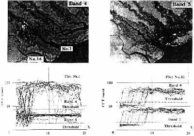
Fig. -1 Images and profiles of CCT count of Band 4 and 5 across a stand for two sampling plots in the mouth of the Inderagiri River, Riau, Sumatera
Stand was not muddy in plot 1 and a nipa stand was adjacent to a channel with muddy water in plot 16. As there was a difference of almost 15 for threshold value of band 4 between two plots, its was difficult to make good separation with either value. The correction became difficult under such conditions. The threshold value was more widely adaptable in this area.
Masking that following procedures with threshold values decided by he way mentioned above were shown in Fig. 2 and described below.
- Decision of the threshold value in band 5 and binarization : image A (mangrove forest and land area to white of 255, water to black of 0)
- Decision of the threshold value in band 5 and binarization : image B (land area to white, mangrove forest and waters to black)
- Reverse of B: image C (mangrove forest and water to white, and area to black)
- Subtraction of B from A : image D (mangrove forest to white, land area and water to black)
- Reverse of D: image E (mangrove forest to white, land area and water to black)
- Subtraction of A from images of each band: imagery data set to classify water area (mangrove forest land area to black water to gray between 0 and 255)
- Subtraction of E from images of each band: imagery data set to classify mangrove forest (land area and waters to black mangrove forest to gray)
- Subtraction of C from images of each band: imagery data set to classify land area (mangrove forest and waters to black land area to gray)
- Classification of each data set: image F, G and H
- Overlay of three image of F,G and H: image I as product 1
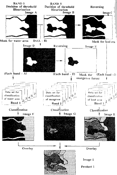
Fig.-2 Conception of masking and following procedure
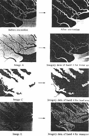
Photo.-1 Examples of images produced from masking and following procedures shown in Fig.-2
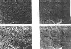
Photo. 2 Examples of classified color image (left: by multilevel slice method, right: by maximum likelihood method, above, classified with whole data, below: overlaid result of classification with separated three data set)
When the classification is not needed for the outside of mangrove forest, it is effective to overlay image G to the three bands color composition with the data set masked by image D.
3.Result and Conclusion
Image in the procedures were shown in Photo.-I. Two classification were tried with multi-level slice method and maximum likelihood method. The results were comparatively shown in Photo-2. It was effective to improve classification accuracy by the proposed way comparatively with the classification of whole target area. For multilevel slice method, the number of unclassified pixel was clearly decreased and three was no erroneous classification among three of mangrove forest, land area and waters for maximum likelihood method.
References
- Dwi Setyono & Sato, K.: Simolarities between Mandah, Sumatera and Iromote, Okinawa on Distribution of TM Data of Landsat 5 in the Multidimentsional Space for Mangrove and Surrounding, Proc. Of the intenational Symposium on Vegetation Monitoring, 298-303, (1995)
- Dwi Setyono & Sato, K.: Structure of Thematic Mapper Data of Landsat 5 for Mangrove Are in the River Mouth of Inderagiri, Riau, Sumatera, era, Proc. Of the 5 th ACRS, Vol,2, g-5-1-6, (1994)
- M.U. Chaudhuy,: Monitoring the Ecological Status of the Mnagrove Forest of Sunderbans in Bangladesh, Application of Remote Sensing in Asia and Oceania, Asian Association on Remote Sensing, 286-291, (1991)
- Sato, K., D. Setyono & Takezaki, K.: Mask Procedure for Effective Classification and Expression on Mangrove Area with TM Data of Landsat 5,Proc. Of the 16th ACRS, p-7-1-6, (1995)
- Sato, D, D. Setyono & S.E. Dah: Structure of Satellite Data for Mangrove Area in Okinawa -Structure of TM Data of Landsat 5 for Mnagrove Area in Iriomote Island - , Proc. Of the 14th ACRS, E-3-1-6, (1993)
- S.Vibulsreshth, B. Klankamsore, S. Ratanasermpong & C. Silapathong: Mangrove Forest Eco-system and its Land Use Zoning by Remote Sensing, Proc. Of the 7th ACRS, C-10-1-12, (1886)