| GISdevelopment.net ---> AARS ---> ACRS 1996 ---> Global Environment |
Generation of Global
Terrestrial Biomass Map by Integrating Satellite Data and Carbon Dynamics
Model
Hua HU*, Ryosuke Shibasaki*, Elgene O. Box**
*Institute of Industrial Science, University of Tokyo (Japan)
**Geography Department, University of Georgia (USA)
Hua HU*, Ryosuke Shibasaki*, Elgene O. Box**
*Institute of Industrial Science, University of Tokyo (Japan)
**Geography Department, University of Georgia (USA)
Abstract
Biomass is the entire foundation of energetic in ecosystems and the ultimate food source for human being, biomass estimation, therefore, provides a sound basis for monitoring the Earth's environment and evaluating human-induced impacts on the environmental change.
This paper presents a promising approach to estimating biomass by integrating satellite data and carbon dynamics model. Anural actual net primary productivity (NPP) is first estimated with monthly composite 1-degre AVHRR Normalized Difference Vegetation Index (NDIV) data using the production efficiency approach in which conversion efficiency of canopy absorbed Phtosynthetically active radiation into primary production is considered. NPP estimates are subsequently incorporated into primary production is considered. NPP estimates are subsequently incorporated into a carbon dynamics model, PHYTOMASS model, to simulate biomass accumulation over succession until equilibrium with climate. Ag global map to terrestrial biomass is finally generated based on the estimation results after their validation with field measurements.
Background
Biomass is the total mass of all living organisms, most of it on the Earth is produced by green plants through photosynthesis. Biomass is of fundamental significance in ecosystems, it provides the entire basis of energy flow and food chain. Biomass is also vital for human being the largest portion of our food supply is from the production of plants.
Due to land overuse and deforestation, however, biomass loss and carbon release, in general, has become very serious; this has led to severe environmental problems such as global warming and it might even threaten human's habitation on the Earth in the log run.
Better understanding of biomass status quo and its change due to human activities is, therefore, important and urgent for suitable land use and natural resource conservation. However, very few researches have been conducted on biomass estimation especially on a global scale. On the other hand, many efforts have made in estimating net primary productivity(NPP), that is, the rate of biomass increment, using regression equations and carbon models,. Remote sensing and satellite data provides new capability of estimating plant production. Recently some researchers relate above-ground biomass to satellite spectral reflectance (Prince et l. 1995); however, this kind of relationship holds weak theoretical basis and is thus far from satisfactory. Furthermore, a global map of biomass is still lacing, though biomass data is often required for global research.
Literature Review and Research Approach
Mainly two kinds of approaches to biomass estimation have been proposed in literature, those are, satellite-based approach and model-based approach.
Researches have shown that spectral vegetation indices derived from spectral signals, such as Normalized Difference Vegetation Index (NDVI), is highly related to several vegetation phenomena, including leaf area index, phonology, and net primary production (Gowrd and Dye, 1987; Box et al., 1989). However, biomass does not have strong relationship with vegetation indices in theory, because nowadays commonly used optical sensor data, like NOAA vegetation indices in theory, because nowadays commonly used optical sensor data, like NOAA AVHRR data, normally reflect the features of plant canopy, not much that of plant woody AVHRR data, normally reflect the features of pant canopy, not much that of plant woody components. Microwave observations(e.g. , SAR data) offer potential for estimating biomass and thus appear promising, since microwave, unlike optical sensors, can penetrate through the canopy into in to woody parts and provide their spectral information. Nonetheless, the current limited spatial coverage of microwave data and its suffering from topographic effects have so far been obstacles to global application.
On the other hand, biomass is the assimilation and accumulation of carbon into organic mater determined by carbon fixation and carbon release, therefore, biomass can be estimated by modeling carbon dynamics. However, most carbon models, present are primarily driven by climate parameters so that the estimation results give a sense of long-term potentials and can not really reflect the current time biomass status and biomass change induced by human activities.
In this research, an unique approach is proposed to estimating biomass by integrating both satellite -and model -based approaches. This research approach can be divided into two steps: first NPP is estimated with AVHRR NDVI satellite data using production efficiency approach then biomass is simulated with a carbon dynamics model, PHYTOMASS model.
Production Efficiency Approach to NPP Estimation
Monteith (1972) first introduced the concept of "production efficiency"; he suggested that plant production is strongly correlated with the amount of photosynthetically active radiation absorbed or intercepted by plant canopy eventually conversed in to organic matter. Researches have also indicated that vegetation indices, such as NDVI, are highly related to net primary productivity (Goward et al., 1985). Further researches (Gowad and Dye, 1987; Ruimy et al. 1994) have subsequently shown that the fraction of canopy-absorbed radiation (fapar) can be linearly related to NDVI,. Therefore, NPP can be estimated with NDVI in the form:
NPP = Î*å(APAR)
= Î*å( fapar
*PAR) = Î*å (
fapar (NDVI)*PAR)
Where ,
NDVI is normalized difference vegetation index,
PAR is Phtosynthetically active radiation (MJ/m2)
APAR is photosynthetic ally active radiation absorbed by canopy (MJ/m2)
å (APAAR) is the annual sum of APAR ((MJ/m2)
NPP is net primary productivity (g/m2/year)
fapar is the APAR fraction of PAR,
Î is conversing efficiency of APAR into primary production (g/MJ).
In this research, conversion efficiency Î) is treated constant, 1.5g/MJ, based on Monteith's (1977) conclusion and Ruimy et al.'s (1994) experimental result. And the fapar -NDVI relationship equation follows that suggested by Ruimy et al. (1994), which was derived from corrected and filtered NDVI:
fapar = -0/+*NDVI
PHYTHOMASS Model for Biomass Simulation
PHYTOMAS, developed BY Box (unpublished, in progress), is a carbon dynamics model, simulating biomass accumulation and related biometabolism over vegetation succession unit it reaches a climatic steady state. The underlying principle of this model is that the production processes, at broad scales, are controlled mainly by ambient climatic conditions and biomass accumulation is determined primarily by the climatically driven production-respiration balance.
In PHTOMASS, metabolism is based on globally calibrated annual models portioned bioclimatically for monthly potentials which are then modified by stochastic growth models to give running increments and accumulations of standing biomass. The model can be schematically expressed by the following equation.
B-Bseed + å(DB) =
Bseed + å(NPP-LF-H) = Bseed
+ å(GPP-R) - LF -H)
Where
GPP is gross primary productivity (g/m2/month),
R is respiration (g/m2/month),
NPP is net primary productivity (g/m2/month), equal to GPP-R,
LF is litter fall(g/m2/month),
H is harvest or herbivore (g/m2/month),
B is biomass (g/m2),
Bseed is initial biomass((g/m2),
DB increment of living biomes (g/m2/month), equal to NPP-LF-H,
å(DB) is total amount of biomes increments over succession until equilibrium (g/m2)
In the model, initial biomass is set to 10/2 to start simulation. The model runs on a monthly time step; input data required are only lone-term monthly average temprature and precipitation plus elevation data.
The PHYTOMASS model, based on climatic data, was originally written to predict potential biomass, so it is modified to estimate actual biomass by substituting satellite-based NPP estimate for potential NPP estimates for potential NPP outputs produced in running the model and determining the ratio of harvest/herbivory to NPP at each site with respect to its intensity of agricultural cultivation.
Research Framework
Research framework of integration of production efficiency approach and PHYTOMASS model is illustrate in Figure 1.
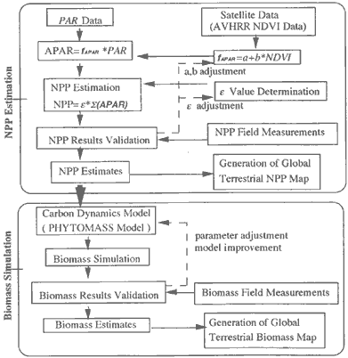
Figure Research Framework of Integration of Production Efficiency Approach and PHYTOMASS Model
Data
Data required include NDVI and PAR data for NPP estimation, and average monthyly temperature and precipitation, elevation data and global map of cultivation intensity for biomass simulation.
Monthly 1-degree AVHRR NDVI data set for 1989 is used in this research, accessed from the Internet website of NOAA Distributed Active Archive Centere (DAAC). PAR data for 1989 is from the global solar radiation data set developed by Eck and Dye (1991); spatial coverage is within 66o North /South latitude. Leemans and Cramer mean monthly temperature and precipitation data sets are for input in running the PHYTOMAS model.
Since these data sets come from difficult sources as different spatial resolution, all the data sets are thus converted into an uniform resolution, 0.5 degree, in laitude /longitude projection for data integrity and data comparability.
Results and Validation
The estimated global actual NPP for 1989 is shown in Figure 2.
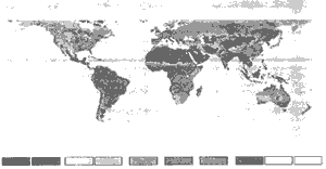
Figure 2. Satellite -based Annual Actual NPP for 1989
The NPP estimates are validated with only 14 sites of field measurement available; the correlation coefficient ® is 0.65.
The simulated global actual biomass for 1989 is shown in Figure 3.
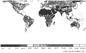
Figure 3 Satellite-based Actual Biomass for 1989
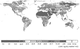
Figure 4 Climate-based Potential Biomass
The biomass estimates are validated with 98 sites of field measurements; the correction coefficient is 0.44.
Discussion
The low biomass correlation coefficient (0.44) can be, in part, attributable to the validation data themselves, since there exit many problems and uncertainties with their measurement and quality. These measurements were conduced mainly during the 1960-1970s, representing a variety of measurement methods (e.g., harvesting and gas-exchange) all of which are laborious and imprecise (Box, 1989). The validation results may not either application to the general case due to the biased distribution of biomass validation data. In addition, different spatial scales between biomass estimates (0.5 degree) and field measurements (point-based) make absolute validation difficult to achieve. The validation results should be, therefore, considered with caution until more reliable and scale-appropriated field biomass data become available.
Conversion efficiency, e, is a variable introduction great incertitude on the estimates. e is treated here constant, however, many researches have shown its value variation for natural vegetation vs. crops, woody vs. herbaceous vegetation, and C3 vs. C4 metabolism species. e is also constrained by environmental parameters, mainly air temperature, vapor pressure deficit, and soil moisture. Assuming e biome-specific probably can increase the accuracy of the estimation NPP and consequently that of biomass, since a mean e per major ecosystem integrates well the effects of environmental parameters as well as interspecies variation.
Scaling problem, occurred by converting all data sets of different spatial resolution to an uniform 0.5 degree by 0.5 degree, results in data of different sources and types inconsistenet in space; this problem is significant especially in coastal areas, mountains, or other complex terrain (Box, et al., 1989).
The use of an empirical linear relationship between fAPAR and NDVI can also bring about probable errors particularly in area with low NDVI (Ruimy, 1994).
The PHYTOMASS model itself still needs modification. As can be seen in Figure 3, biomass in eastern Siberia area is underestimated, while biomass is overestimated for some grasslands.
Conclusion
Biomass is estimated by integrating AVHRR NDVI data PHYTOMASS carbon dynamics model. Based on he estimation results a global map of terrestrial actual biomass for 1989 has generated. This map shows similar pattern of biomass distribution worldwide as the climate-based potential biomass map, meanwhile, it indicates drastic biomass decrease in the intensively agriculturally cultivated areas, suggesting great effects of human activities on biomass change.
Integration of satellite data and carbon dynamics model presents a promising approach to estimating biomass. Application of this approach for use with time series of satellite data represents a further step towards the ability to monitor biomass status, detect its change over time and space, and evaluate human-induced impacts.
References
Biomass is the entire foundation of energetic in ecosystems and the ultimate food source for human being, biomass estimation, therefore, provides a sound basis for monitoring the Earth's environment and evaluating human-induced impacts on the environmental change.
This paper presents a promising approach to estimating biomass by integrating satellite data and carbon dynamics model. Anural actual net primary productivity (NPP) is first estimated with monthly composite 1-degre AVHRR Normalized Difference Vegetation Index (NDIV) data using the production efficiency approach in which conversion efficiency of canopy absorbed Phtosynthetically active radiation into primary production is considered. NPP estimates are subsequently incorporated into primary production is considered. NPP estimates are subsequently incorporated into a carbon dynamics model, PHYTOMASS model, to simulate biomass accumulation over succession until equilibrium with climate. Ag global map to terrestrial biomass is finally generated based on the estimation results after their validation with field measurements.
Background
Biomass is the total mass of all living organisms, most of it on the Earth is produced by green plants through photosynthesis. Biomass is of fundamental significance in ecosystems, it provides the entire basis of energy flow and food chain. Biomass is also vital for human being the largest portion of our food supply is from the production of plants.
Due to land overuse and deforestation, however, biomass loss and carbon release, in general, has become very serious; this has led to severe environmental problems such as global warming and it might even threaten human's habitation on the Earth in the log run.
Better understanding of biomass status quo and its change due to human activities is, therefore, important and urgent for suitable land use and natural resource conservation. However, very few researches have been conducted on biomass estimation especially on a global scale. On the other hand, many efforts have made in estimating net primary productivity(NPP), that is, the rate of biomass increment, using regression equations and carbon models,. Remote sensing and satellite data provides new capability of estimating plant production. Recently some researchers relate above-ground biomass to satellite spectral reflectance (Prince et l. 1995); however, this kind of relationship holds weak theoretical basis and is thus far from satisfactory. Furthermore, a global map of biomass is still lacing, though biomass data is often required for global research.
Literature Review and Research Approach
Mainly two kinds of approaches to biomass estimation have been proposed in literature, those are, satellite-based approach and model-based approach.
Researches have shown that spectral vegetation indices derived from spectral signals, such as Normalized Difference Vegetation Index (NDVI), is highly related to several vegetation phenomena, including leaf area index, phonology, and net primary production (Gowrd and Dye, 1987; Box et al., 1989). However, biomass does not have strong relationship with vegetation indices in theory, because nowadays commonly used optical sensor data, like NOAA vegetation indices in theory, because nowadays commonly used optical sensor data, like NOAA AVHRR data, normally reflect the features of plant canopy, not much that of plant woody AVHRR data, normally reflect the features of pant canopy, not much that of plant woody components. Microwave observations(e.g. , SAR data) offer potential for estimating biomass and thus appear promising, since microwave, unlike optical sensors, can penetrate through the canopy into in to woody parts and provide their spectral information. Nonetheless, the current limited spatial coverage of microwave data and its suffering from topographic effects have so far been obstacles to global application.
On the other hand, biomass is the assimilation and accumulation of carbon into organic mater determined by carbon fixation and carbon release, therefore, biomass can be estimated by modeling carbon dynamics. However, most carbon models, present are primarily driven by climate parameters so that the estimation results give a sense of long-term potentials and can not really reflect the current time biomass status and biomass change induced by human activities.
In this research, an unique approach is proposed to estimating biomass by integrating both satellite -and model -based approaches. This research approach can be divided into two steps: first NPP is estimated with AVHRR NDVI satellite data using production efficiency approach then biomass is simulated with a carbon dynamics model, PHYTOMASS model.
Production Efficiency Approach to NPP Estimation
Monteith (1972) first introduced the concept of "production efficiency"; he suggested that plant production is strongly correlated with the amount of photosynthetically active radiation absorbed or intercepted by plant canopy eventually conversed in to organic matter. Researches have also indicated that vegetation indices, such as NDVI, are highly related to net primary productivity (Goward et al., 1985). Further researches (Gowad and Dye, 1987; Ruimy et al. 1994) have subsequently shown that the fraction of canopy-absorbed radiation (fapar) can be linearly related to NDVI,. Therefore, NPP can be estimated with NDVI in the form:
Where ,
NDVI is normalized difference vegetation index,
PAR is Phtosynthetically active radiation (MJ/m2)
APAR is photosynthetic ally active radiation absorbed by canopy (MJ/m2)
å (APAAR) is the annual sum of APAR ((MJ/m2)
NPP is net primary productivity (g/m2/year)
fapar is the APAR fraction of PAR,
Î is conversing efficiency of APAR into primary production (g/MJ).
In this research, conversion efficiency Î) is treated constant, 1.5g/MJ, based on Monteith's (1977) conclusion and Ruimy et al.'s (1994) experimental result. And the fapar -NDVI relationship equation follows that suggested by Ruimy et al. (1994), which was derived from corrected and filtered NDVI:
PHYTHOMASS Model for Biomass Simulation
PHYTOMAS, developed BY Box (unpublished, in progress), is a carbon dynamics model, simulating biomass accumulation and related biometabolism over vegetation succession unit it reaches a climatic steady state. The underlying principle of this model is that the production processes, at broad scales, are controlled mainly by ambient climatic conditions and biomass accumulation is determined primarily by the climatically driven production-respiration balance.
In PHTOMASS, metabolism is based on globally calibrated annual models portioned bioclimatically for monthly potentials which are then modified by stochastic growth models to give running increments and accumulations of standing biomass. The model can be schematically expressed by the following equation.
Where
GPP is gross primary productivity (g/m2/month),
R is respiration (g/m2/month),
NPP is net primary productivity (g/m2/month), equal to GPP-R,
LF is litter fall(g/m2/month),
H is harvest or herbivore (g/m2/month),
B is biomass (g/m2),
Bseed is initial biomass((g/m2),
DB increment of living biomes (g/m2/month), equal to NPP-LF-H,
å(DB) is total amount of biomes increments over succession until equilibrium (g/m2)
In the model, initial biomass is set to 10/2 to start simulation. The model runs on a monthly time step; input data required are only lone-term monthly average temprature and precipitation plus elevation data.
The PHYTOMASS model, based on climatic data, was originally written to predict potential biomass, so it is modified to estimate actual biomass by substituting satellite-based NPP estimate for potential NPP estimates for potential NPP outputs produced in running the model and determining the ratio of harvest/herbivory to NPP at each site with respect to its intensity of agricultural cultivation.
Research Framework
Research framework of integration of production efficiency approach and PHYTOMASS model is illustrate in Figure 1.
Figure Research Framework of Integration of Production Efficiency Approach and PHYTOMASS Model
Data
Data required include NDVI and PAR data for NPP estimation, and average monthyly temperature and precipitation, elevation data and global map of cultivation intensity for biomass simulation.
Monthly 1-degree AVHRR NDVI data set for 1989 is used in this research, accessed from the Internet website of NOAA Distributed Active Archive Centere (DAAC). PAR data for 1989 is from the global solar radiation data set developed by Eck and Dye (1991); spatial coverage is within 66o North /South latitude. Leemans and Cramer mean monthly temperature and precipitation data sets are for input in running the PHYTOMAS model.
Since these data sets come from difficult sources as different spatial resolution, all the data sets are thus converted into an uniform resolution, 0.5 degree, in laitude /longitude projection for data integrity and data comparability.
Results and Validation
The estimated global actual NPP for 1989 is shown in Figure 2.
Figure 2. Satellite -based Annual Actual NPP for 1989
The NPP estimates are validated with only 14 sites of field measurement available; the correlation coefficient ® is 0.65.
The simulated global actual biomass for 1989 is shown in Figure 3.
Figure 3 Satellite-based Actual Biomass for 1989
Figure 4 Climate-based Potential Biomass
The biomass estimates are validated with 98 sites of field measurements; the correction coefficient is 0.44.
Discussion
The low biomass correlation coefficient (0.44) can be, in part, attributable to the validation data themselves, since there exit many problems and uncertainties with their measurement and quality. These measurements were conduced mainly during the 1960-1970s, representing a variety of measurement methods (e.g., harvesting and gas-exchange) all of which are laborious and imprecise (Box, 1989). The validation results may not either application to the general case due to the biased distribution of biomass validation data. In addition, different spatial scales between biomass estimates (0.5 degree) and field measurements (point-based) make absolute validation difficult to achieve. The validation results should be, therefore, considered with caution until more reliable and scale-appropriated field biomass data become available.
Conversion efficiency, e, is a variable introduction great incertitude on the estimates. e is treated here constant, however, many researches have shown its value variation for natural vegetation vs. crops, woody vs. herbaceous vegetation, and C3 vs. C4 metabolism species. e is also constrained by environmental parameters, mainly air temperature, vapor pressure deficit, and soil moisture. Assuming e biome-specific probably can increase the accuracy of the estimation NPP and consequently that of biomass, since a mean e per major ecosystem integrates well the effects of environmental parameters as well as interspecies variation.
Scaling problem, occurred by converting all data sets of different spatial resolution to an uniform 0.5 degree by 0.5 degree, results in data of different sources and types inconsistenet in space; this problem is significant especially in coastal areas, mountains, or other complex terrain (Box, et al., 1989).
The use of an empirical linear relationship between fAPAR and NDVI can also bring about probable errors particularly in area with low NDVI (Ruimy, 1994).
The PHYTOMASS model itself still needs modification. As can be seen in Figure 3, biomass in eastern Siberia area is underestimated, while biomass is overestimated for some grasslands.
Conclusion
Biomass is estimated by integrating AVHRR NDVI data PHYTOMASS carbon dynamics model. Based on he estimation results a global map of terrestrial actual biomass for 1989 has generated. This map shows similar pattern of biomass distribution worldwide as the climate-based potential biomass map, meanwhile, it indicates drastic biomass decrease in the intensively agriculturally cultivated areas, suggesting great effects of human activities on biomass change.
Integration of satellite data and carbon dynamics model presents a promising approach to estimating biomass. Application of this approach for use with time series of satellite data represents a further step towards the ability to monitor biomass status, detect its change over time and space, and evaluate human-induced impacts.
References
- Box, E.O., Holben, B, and Kalb, V. 1989, Accuracy of the AVHRR vegetation index as a predictor of biomass, primary productivity and net CO2 flux. Vegetation, 90:71-89
- Eck, T.F., and Dye, D.G., 1991, Satellite estimation of incident phytosynthetically active radiation using ultraviolet reflectance. Remote Sens. Environ., 38:135-146.
- Goward, S., Tucker, C.J., and Dye,D., 1985, North American vegetation patterns observed with the NOAA-7 advanced very high resolution radiometer, Vegetatio, 64:3-14
- Gorwar, S.N., and Dye, D.G, 1987, Evaluating North American net primary productivity with satellite observations, Adv. Space Res. 7(11): 165-174
- Monteith, J.L. 1972, Solar radiation and productivity in tropical exosystems, J. Appl.Ecol. 9:747-766
- Monteith, J.L., 1977, Climate and efficiency of crop production in Britain, Phil. T. Soc., 107:749-774
- Prince, S.D., Goward, S.N., 1995, Global primary production : a remote sensing approach, Journal of biogeography, 22:2829-2849
- Ruimy, A., Saugier, B., et al., 1994, Methodology for the estimation of terrestrial net primary production from remotely sensed data, Journal of Geophysical Research, 99:5263-5283