| GISdevelopment.net ---> AARS ---> ACRS 1996 ---> Global Environment |
Application of PAR in
Estimation of Agricultural Productivity
K. S. Rajan and Ryosuke Shibasaki
Murai-Shibashki Lab, Institute of Industrial Science,
University of Tokyo
7-22-1, Roppongi, Minato-Ku Tokyo 106, Japan
K. S. Rajan and Ryosuke Shibasaki
Murai-Shibashki Lab, Institute of Industrial Science,
University of Tokyo
7-22-1, Roppongi, Minato-Ku Tokyo 106, Japan
Abstract
Agricultural productivity is of great importance in the context of global food supply, especially due to the dramatic rise in population in the last century. It is also of significance in understanding the changes brought about in the agricultural land use patterns and modeling such changes.
In the paper, we report the study on the estimation of the crop productivity based on local topological, soil, climatic characteristics and the availability of photosynthetically active radiation (PAR). PAR is used in combination with climatic factors to better the results obtained by purely climate-based productivity estimation relations.
Introduction:
The influence of human activities on the environment is of great concern and the need to understand it stems from the impacts of such changes. Agricultural practice is one such major activity which needs to be understood as a step towards better management or our limited resources. The dramatic rise in population in the last century has led to an expansion of the land under agricultural uses. The estimation of agricultural productivity, potential to support agriculture and the economic yield o each land unit, is of primary importance in modeling the agricultural landuse distribution in a given region or country, as these are the key factors in modeling the behavior of land owners and developers.
There has been various attempts at the estimation of agricultural productivity for assessing land suitability (Anonymous, 1978), for total biomass accumulation or terrestrial primary production (Dy and Goward, 1994), etc. The production estimation is based on the process of photosynthesis, by which a fraction of the incident solar energy is conversed into biomas. The absorbed solar energy calculations originally used highly empirical relations based on climatic conditions (Anonymous, 1978). Recent works have made an attempt to derive these based on remote sensing data (Goward and Dye, 1995), but have been applied to estimation of biomass at regional to global scales. We have made an attempt at applying the use of remote sensing data in combination with local topological, soil, and climatic characteristics to estimate productivity at the land unit level.
Study Area:
The kindom of Thailand was choosen as the case study area, as it povided us with an opportunity to compare a purely climate-based approach with the PAR-based appoach. A previous study on agricultural productivity estimation based on climatic and ground conditions was doen by the authors (Rajan, et.al, 1995). Village -based productivity values were collected to verify the applicability of the approach.
Background :
The central idea to the estimation of the agricultural productivities is that there is a strong linkage between the climatic conditions and cropping patterns (Walter and Box, 1976). The climatic factors are used as the main factor determining the suitability of the crop species. These factors help in describing the plant responses more mechanistically and thus mimic important eco-physiological processes. (Leemans and van der Born, 1994). The simple photosynthetic model for crops was provided by deWit (1965), and this was later adopted by the FAO in its project on the agro-ecological zones (Anonymous 1978). The central concept of this approach is the length of the growing period and the photosynthetic efficiency of the crops. The net biomass (Bn) is determined by both photosynthesis (gross biomass, Bg) and respriation loses ®.
Bn = Bg-R
The final yield (By) is then calculated as follows:
By = Bn * Hi
Where, Hi is the harvest index, defined as the fraction of the net biomass of the crop that is economically useful (e.g. grain in cereals, Sugar in sugarcane. Etc.).
The results obtained here are the rain-fed potential productivities. This procedure uses the climate factors to evaluate the biomass acculation during the growing period.
Methodology
The climate-based productivity estimation was first carried out, as detailed in figure 1 below. The rain-fed productivity was adjustment for soil and topographic characteristics and the availability of irrigation was considered.
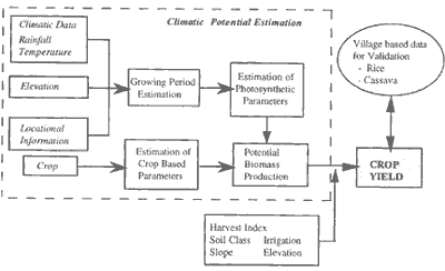
Figure 1 Flow diagram of Climate-based Agricultural Productivity Estimation
In the second part of the study, the photosynthetically active radiation that was available during the growing period of the crop was introduced at the box of 'estimation of photosynthetic parameters'. The photosynthetically active radiation (PAR) incident on the surface, estimated from the NIMBUS-7 TOMS satellite, was used.
Discussion
The introduction of the satellite-derived PAR data improved the estimation of yields. This may be attributed to a more realistic expression of the vegetation canopy cover that was not at al considered during the climate-based estimation. Also, it may be because the temperature and location dependent values of PAR, given by deWit were replaced by that derived from remote sensing.
In both the cases, we see that the harvest index is of importance, as it describes the economic yields of the crops. The harvest index depends on a number of factors like the genetic potential of the crop - whether high yielding or low yielding and water or low yielding and water regime - rained to irrigated. These are inherent to the crop variety in use and can be referred to use the unconstrained harvest yield index. But then, the level of agricultural inputs along with the soil conditions and topography also contribute to the harvest index at a given location, these can be referred to as the constraint factors. Thus it is a combination of the two. Efforts must be made to sutably modify this factor to take into account the additional agricultural inputs such as fertilizer, etc. to increase the yield.
References
Agricultural productivity is of great importance in the context of global food supply, especially due to the dramatic rise in population in the last century. It is also of significance in understanding the changes brought about in the agricultural land use patterns and modeling such changes.
In the paper, we report the study on the estimation of the crop productivity based on local topological, soil, climatic characteristics and the availability of photosynthetically active radiation (PAR). PAR is used in combination with climatic factors to better the results obtained by purely climate-based productivity estimation relations.
Introduction:
The influence of human activities on the environment is of great concern and the need to understand it stems from the impacts of such changes. Agricultural practice is one such major activity which needs to be understood as a step towards better management or our limited resources. The dramatic rise in population in the last century has led to an expansion of the land under agricultural uses. The estimation of agricultural productivity, potential to support agriculture and the economic yield o each land unit, is of primary importance in modeling the agricultural landuse distribution in a given region or country, as these are the key factors in modeling the behavior of land owners and developers.
There has been various attempts at the estimation of agricultural productivity for assessing land suitability (Anonymous, 1978), for total biomass accumulation or terrestrial primary production (Dy and Goward, 1994), etc. The production estimation is based on the process of photosynthesis, by which a fraction of the incident solar energy is conversed into biomas. The absorbed solar energy calculations originally used highly empirical relations based on climatic conditions (Anonymous, 1978). Recent works have made an attempt to derive these based on remote sensing data (Goward and Dye, 1995), but have been applied to estimation of biomass at regional to global scales. We have made an attempt at applying the use of remote sensing data in combination with local topological, soil, and climatic characteristics to estimate productivity at the land unit level.
Study Area:
The kindom of Thailand was choosen as the case study area, as it povided us with an opportunity to compare a purely climate-based approach with the PAR-based appoach. A previous study on agricultural productivity estimation based on climatic and ground conditions was doen by the authors (Rajan, et.al, 1995). Village -based productivity values were collected to verify the applicability of the approach.
Background :
The central idea to the estimation of the agricultural productivities is that there is a strong linkage between the climatic conditions and cropping patterns (Walter and Box, 1976). The climatic factors are used as the main factor determining the suitability of the crop species. These factors help in describing the plant responses more mechanistically and thus mimic important eco-physiological processes. (Leemans and van der Born, 1994). The simple photosynthetic model for crops was provided by deWit (1965), and this was later adopted by the FAO in its project on the agro-ecological zones (Anonymous 1978). The central concept of this approach is the length of the growing period and the photosynthetic efficiency of the crops. The net biomass (Bn) is determined by both photosynthesis (gross biomass, Bg) and respriation loses ®.
The final yield (By) is then calculated as follows:
Where, Hi is the harvest index, defined as the fraction of the net biomass of the crop that is economically useful (e.g. grain in cereals, Sugar in sugarcane. Etc.).
The results obtained here are the rain-fed potential productivities. This procedure uses the climate factors to evaluate the biomass acculation during the growing period.
Methodology
The climate-based productivity estimation was first carried out, as detailed in figure 1 below. The rain-fed productivity was adjustment for soil and topographic characteristics and the availability of irrigation was considered.
Figure 1 Flow diagram of Climate-based Agricultural Productivity Estimation
In the second part of the study, the photosynthetically active radiation that was available during the growing period of the crop was introduced at the box of 'estimation of photosynthetic parameters'. The photosynthetically active radiation (PAR) incident on the surface, estimated from the NIMBUS-7 TOMS satellite, was used.
Discussion
The introduction of the satellite-derived PAR data improved the estimation of yields. This may be attributed to a more realistic expression of the vegetation canopy cover that was not at al considered during the climate-based estimation. Also, it may be because the temperature and location dependent values of PAR, given by deWit were replaced by that derived from remote sensing.
In both the cases, we see that the harvest index is of importance, as it describes the economic yields of the crops. The harvest index depends on a number of factors like the genetic potential of the crop - whether high yielding or low yielding and water or low yielding and water regime - rained to irrigated. These are inherent to the crop variety in use and can be referred to use the unconstrained harvest yield index. But then, the level of agricultural inputs along with the soil conditions and topography also contribute to the harvest index at a given location, these can be referred to as the constraint factors. Thus it is a combination of the two. Efforts must be made to sutably modify this factor to take into account the additional agricultural inputs such as fertilizer, etc. to increase the yield.
References
- Anonymous, 1978L Report on the Agro-Ecological Zones Project. Food and agricultural Organization of the United National, World Soil Resources Report 48, Rome.
- Dye, D.G. and Goward, S.N., 1994 : remote Sensing for Biosphere Modeling and mentoring. Proceeding of the 15 the Asian Conference on Remote Sensing, L-3.
- Leemans. R. and Solmon A.M., 1993: modeling the Potential Change in yield and Distribution of the Earth's Crops under a Warmed Climate, Climate Research., Vol.3, 79-96.
- Leemans, R. and van den Born, G.J. 194l Determining the Potential Distribution, Crops and Agricultural Productivity. Water Air and Soil Pollution Vol. 76, 133-161
- Office of agricultural Economics, Bangkok, Thailand : Agricultural Statistics of Thailand. (years 1980/81 to 1993/94)
- Rajan, K.S., Shibasaki, R. and Takagi, M., 1995 : Simulating Agricultural Land use changes in Thailand. Proceedings of the 16th Asian Conference on Remote Sensing, Q-3.
- Walter, H. and Box, E., 1976l Global Classification of natural terrestrial ecosystems. Vegetation, Vol. 32, 75-81.
- deWit, C.T. 1965L Photosynthesis of Leaf Canopies. Agricultural Research Report 663 , center for Agricultural Publication and Documentation, Wageningen.