| GISdevelopment.net ---> AARS ---> ACRS 1996 ---> GIS |
Use of Remote Sensing and GIS
in Urban Hydrologic Analysis
S.Herath1,
K.Musiake1, S.Wijesekara2, and
L.Samarakoon3
1Institute of Industrial Science,
University of Tokyo, 7-22-1, Roppongi
Minato-ku, Tokyo 106, Japan
Tel: 03-3402-6231 Fax: 03-3402-4165
2Department of Civil Engineering,
University of Moratuwa
Moratuwa, Sri Lanka
Tel: +49-1-873148
3Nippon Koei Co. Ltd.,
203 Takasaki, Kukiezaki, Inashiki, Ibaraki Ken, Japan
Tel : 0298-71-2045 Fax: 0298-71-2022
Abstract 1Institute of Industrial Science,
University of Tokyo, 7-22-1, Roppongi
Minato-ku, Tokyo 106, Japan
Tel: 03-3402-6231 Fax: 03-3402-4165
2Department of Civil Engineering,
University of Moratuwa
Moratuwa, Sri Lanka
Tel: +49-1-873148
3Nippon Koei Co. Ltd.,
203 Takasaki, Kukiezaki, Inashiki, Ibaraki Ken, Japan
Tel : 0298-71-2045 Fax: 0298-71-2022
Urban hydrological cycle is driven by water inputs in the form of rainfall and water supply to urban area. Hydrlogy is generally analyzed by the hydrologists only considering the water cycle resulting from the rainfall, where as drainage engineers are mainly concerned with the discharge of waste water and the overland flow resulting from storms. Where urban environment is concerned, it is important to consider the total water cycle resulting from both inputs as water supplies may consist nearly half of total water input to the catchment in heavily urbanized areas. In this paper we present a method to compute water balance in urban areas. In this paper we present a method to compute water balance in urban areas using different database to estimate the water quantities that enter the catchments and their subsequent distributions. Two cases are presented, in an experimental catchment in the suburbs of Tokyo, Japan, and another in Colombo, Sir Lanka.
1. Introduction
In order to analyze the urban hydrological cycle, it is first necessary to identify the water movement for both natural and artificial water cycles. Artificial water cycle here refers to the water supply, usage and drainage by he in habitants of the catchment, whearas the natural water cycle refers to tht resulting from the rainfall, which turn into overland flow, infiltration evaportanspiration, ground water discharge and river flow. Thee are sophisticated methods for modeling each of these components individually, but only few attempts have been made to modeling each of these components individually, but only few attempts have been made to analyze the total water cycle inurbane area. Understanding of the total water cycle is important to assess and improve the urban environment, where most of the world population is going to live with the turn of the century.
Fig. 1 shows a schematic view of the main components of the urban water cycle. The quantifying of this water cycle is a major problem, because most of existing monitoring systems are grated to maintain and design different components of the system, and not to estimate the behavior of the total system. When detailed information are avaibable, it is possible to describe the complete hydrological cycle using distributed hydrologic models which can simulate the spatial and temporal variation of the different components. For example, Hearth et. al (1996) described a GIS based distributed hydrologic model and validated it with an application to hurly stream flow data and Nakamura et. al (1996) describe the application of a sistributed model to an urban catchment which shows very good arement with observed groundwater levels and hydrographs at several streams in the catchment. However, these models requie extensive computational resource for model set up and execution. In this paper we investigate a simplified method of estimating catchment water balance using spatial datasets which would help in quantitating the components shown in Fig. 1.
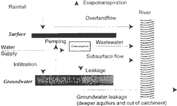
Figure 1 Schematic view of the urban water cycle components
2. Estimationof the Component of the water Cycle
The water balance at the surface can e estimated by,
| ¶St ----- ¶t |
= Rt - Et - Inft (1) |
where S = Surface Storage, R = Rainfall, E = Evaporationand Inf= Infiltration Amount. The subscript l denote either pervious or impervous fraction of the grid. When the surface Storage, S exceeds the maximum storage capacityof the grid Smax1, surface runoff occurs. The amount of direct runoff frompervius and impervious fractions in each grid (Dr1) are then given by,
Dr1 = Smax1 - S1 (2)
To estimate Inf, th infiltration capacity of the soil has to be estimated. This is only relevant for the previous areas as the infiltration capacityof the imprevius areas is zero.For water balance estimation infiltration is approximated by the infiltration capacity of the top soil layer. The infiltration capacity is limited by the maximum infiltrating velocity which is eqivalent to the soil saturated conductivity. When rainfall data resolution is not high enough (i.e. higher than of the order of minutes) the rainfall intensity gets averaged and infiltration capacity tends to get oversged and infiltration capaicity tends to get overrstimated. Therefore an exponential distribution of rainfall is assumed and the infiltration capacity is estimated as,
Rex = Rav Exp (-K0 / Rav) (3)
Where Rex is the rainfall excess, Rex is the average rainfall within the measuring interval and R0 is the saturated conductivity of the soil.
The infiltrating amount of water is then estimated as (1.-imf) x Rex where imf stands for the impervious fraction of the grid. This water then flows as subsurface flow or infiltrates down to the groundwater . The amount of groundwater recharge (Rchg) and subsurface flow (subft) components are estimated as,
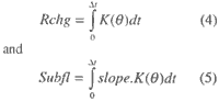
where K (q) is the average conductivity of the top soil layer. These equation (4) and (5) been shown to be good approximates to the more complete estimation to be derived by solution of the Richards equation (Ni et. al., 1993).
For the water supply, the transformation of this input is estimated as,
Qs(T) = I(T)xp (6)
QI(T) =Qs(T) x Lc (7)
Qd(T)=Qs(T) -QI(T) -Qu(T) (8)
Where Qs(T) is the water supply within the period T, I(T) is the per capita water consumption/demand unit, p is the demand density (i.e. population density), Ql is the loss of water during trasmission, Qd is the drainage discharge, and Qu is the water used, or los which does not enter to the drainage network.
3. Data Source for Deriving Attrigutes for the Analysis
Table 2. shows the different information layers that can by used for the estimation of components of the water cycle.
| Information Layer | Attributes to be derived |
| Digital Elevation Model | Catchment Boundaries, Surface gradients, Stream network |
| Landuse Map | Previous and Impervious area
estimation Leaf area inde for evaporation estimation Surface rughness for overland flow computation |
| Soil type distribution | Soil hydraulic properties for infiltration and subsurface flow computation |
| Population distribution | Estimation of water consumption |
| Water supply domains | Estimation water supply and leakage |
| Drainage network | Identification of wastewater routing |
For urban application it is desirable to have these data set in the range of 50 m gird sizes.
4. Case studies
4.1 Water Cycle in an an Urban Catchment in the Suburbs of Tokyo
4.1.1 Description of the Catchment
Stream flow, rainfall, ground water levels climatic variables have been measured in an urban catchment for the past few years. Comprehensive studies on groundwater utilization, catechement is contol and treatment, water supply to the catchment too were carried out. The catchment is control and treatment, water supply to the catchement too were carried out. The catchment is located at the Ebi river basin of Chiba prefecture, Japan. Two stream gauging stations were set up, one at the main stream at a point reprsenting a catchment are of 8.26 km2 and another at a tributary point covering a catchmnt area of 3.25 km2 ( Maehara sub catchment). Fig. 2 shows a sample of discharge measured at the Maehara river. The figure very clearly shows the effect of artificial component, of the urban water cycle. The diurnal of the stream flow on non rainy days represents the discharge to the stream after human water usage.
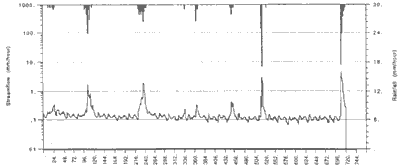
Figure 2 Observed streamflow and rainfall at Maehara Catchment
4.1.2. Topographic Data
The topographic data was obtained from the numerical elevation data sets of Japan Geophysical Survey Institute,. To derive a square data set, re-griding was done to obtain a 50m x 50m data set. To check the validity of the data set, flow directions were estimated from the elevation data set and the rivers were generated. Then this was overlain with the actual river, digitzed. Form this comparison it was seen that the data set has sufficient accuracy to carry out numerical simulation.
4.1.3 Landuse Data
Remote Sensing data were used to drive landuse maps. A SPOT scene (20x20m) was classified using supervised classification methods to obtain the landuse map. To check the accuracy of the classification, aerial photos were digitized and the total landuse areas were compared. The comparison shosed that 20m SHOT data has enough accuracy with deviations less than 3% in different categories. The map obtained was re-girded at 50m resolution to match with the base topographic data.
4.1.4 Previouness and Soil data
For the simulation model, the previous and impervious areas in each grid is required. From the details plans (1:2500 scale) the previous and impervious area ratio for different landuse categories was established. Form the above, pervious fraction was set to 25% for dense residential areas, 40% for residential areas, 0% for water bodies and 100% for other landuse categories. Soil type distraction was digitized using soil distribution maps. The moisture-suction relation for different soils was measured in the laboratory from field soil samples.
4.1.5 Water Supply Data
As the catchment was mainly a residential catchment, the water supply data can be represented well related to the population distribution. A GIS layer for the population distribution was prepared. The water supply data for the catchment was taken from Water Supply Statistics Annual Publication made by the Chiba prefecture office. The per capita demand from this data was estimated as 34 l/person/day, which compared well with random measurements carried out at housing complex. The leakage form the supply lines were to given in the same document at 8% of the total supply. The consumption was estimated by measurements of input and output at housing complex as 15%.
4.1.6 Comparison of Observed and Computed Water Balance value
The computed water balance components with the above datasets are shown in Fig. 3. Annual water balance computed from the observed hydrographic is shown in Fig. 2. Compared with the computed values are shown in table 3.
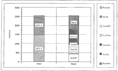
Figure 3 Computed Water Balance Components
| Water supply (mm/yr) | River Discharge (Natural & Leakage)(m/yr) | Artificial Discharge (mm/yr) | |
| Observed | 1076 | 1351 | 839 |
| Computed | 1073 | 1284 | 839 |
While the observed hydrographs cannot be used for detailed decomposition of the water cycle components, the water balance analysis provides a breakdown of the nents and the same time agree with the observed quantities closely.
4.2 Water Balance Components for Colombo, Sir Lanka
A similar study was carried for the total water balance components for Colombo, Sri Lanka. The analysis is only preliminary as complete data sets could not be complied yet. The initial data collected are as follows.
4.2.1. Landuse Map
A Landsat data set was classified to obtain different landuse categories for Colombo area. S there was no other information to validate the areas obtained an attempt was made to generalize the classification procedure so as to obtain a landuse class set that is not subjective to the use of training areas.. Landsat Thermatic Mapper TM data acquired on 1995 January 17 was used of the study. Further, the most recent land cover maps in 1:50,000 were used as reference information for establishing statistical parameters and validating the classified results. Comparison of land cover maps of the area showed that them a in land cover types in the study area can be grouped into three main categories., namely; urban, water bodies and vegetation. These categories can further sub-diveded into different rurban density classes and vegetation categories. Considering the representation of these subdivision in the interest of hydrological modeling it was decided to classify the urban areas into three subdivisions depending on their urban densities, which will help infer the ratio of the pervious and impervious fractions. The main division considered in the vegetating coverage was paddy field and the other two main vegetation categories were homesteads and coconut plantations.
The classification was carried out stepwise, considering specific land cover class at a time, and identifying the best suitable spectral bands to classify it from the others. The result is masked out, and remainingarea was investigated for the next specified class. This procedure was category. Compilation of the final land cover map was carried out by integrating bit mask of each step. The classification is shown in Fig. 4.
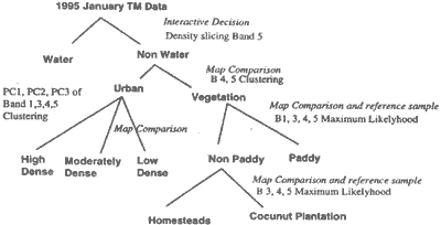
Figure 4 Algorithm used for Landuse classification for Colombo Area
4.2.2 Topographic and Other Data
A DEM was made by digitizing 1:50,000 contur maps for the area. For the water supply, water supply boundaries, and the administrative boundaries were made in to GIS layers. All the data sets were transferred to a single dataset, and polygon data sets were transferred to 50 m grid layers.
4.2.3 Water Supply Data
Water supply production data and metered and un-metered consumption data for 1995, by administrative districts were obtained courtesy of Water Supply and Drainage Board of Sri Lanka, For example, annual supply and estimated consumption data for Kollonawa is shown in Table 4.
| Annual water supply data(m3) | Matered and Estimated Consumption (m3) | Stand Post Consumption (m3) | Unaccounted Water % |
| 3454177 | 1328000 | 1525700 | 45% |
4.3 Hydrologic Cycle Components
Hydrologic cycle components for Kollonnawa area is shown in Fig. 5. For comparison with the previous study, this simulation is carried out for the same meteorologic conditions as for the Tokyo example.
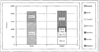
Figure 5 Hydrological Cycle Components for Kollonnawa, Colombo
5. Conclusions
the methodology outlined here is appropriate for a accurate estimation of the water balance of urban catchments. While it was been verified with the monitored catchment, the application to Colombo needs verification together with the refinement of input data and the GIS. Such estimates as described here are useful to establish the proper input land check the avidity of input estimates, prior to detailed counties simulation. Distributed hydrologic models used for catchment simulation are pressure based and require a large amount of computer time. It is practically very difficult to assess the parameter validity using high resolution details inputs in performing repeated computations. The method outlined there uses storages base approach coupled with some transport parameters which require only a small amount of computer time, making it an appropriate preliminary analysis to understand urban water cycle.
References
- Hearth, S., Musiake, and Hironaka, S. (1996) Development and Application of a GIS based Catchment Model for Urban Areas, Proc. 7th International Conference on Urban Storm Drainage, Hannover, Germany, pp. 1 695 -1700.
- Nakamura, S., Saito, M. and Hearth (1996) Development and Application of a Physically Based Distributed Catchment Model in Urban Area, Proc. Int. Conference on Urbn Eng. In Asian Cities, Bangkok, Thailand (to be published in Nov.)
- Ni, G., Herath, S. and Musiake, K(1993) Simulation of Subsurface Flow in a Hillsope, Proc. Annual Conf. Of Soc. Of Water Resources and Hydrology. Pp. 246-247.