| GISdevelopment.net ---> AARS ---> ACRS 1996 ---> GIS |
Combining GIS and Statistical
Analysis for Better Decision Making Local Level Planning
Shyamalie Perera & S.
Sivananthgarajah
P.O. Box 506, Centre for Remote Sensing,
Survey Department, Sri Lanka
Abstract P.O. Box 506, Centre for Remote Sensing,
Survey Department, Sri Lanka
As a developing country Sri. Lanka has tried to keep abreast of technology development as regards resource information generation to support decision making and development of planning activities. Sri Lanka / Swiss Planning Support Project support this objective and it has taken Divisional Secretary area which a basis unit in the planning hierarchy of Sri Lanka for pilot study.
In an attempt for better decision making in planning infrastructure, GIS and socio-economic data has been used in the Divisional Secretary Bulathsinhala for spatial planning.
A problem analysis study was carried out for this administrative unit. It shows the various requirements of the local level people and their problems. These have been categorised into five major groups and given priority to needs of the people. In this study the prority of road development has been analysed as hypothetical case study intergratin the vector adnd Raster GIS and statistical information gives the overall analysis in a more realistic perspective. Finally, this study concludes that developed GIS, has capability of handling planners requirement in a local level planning.
1.0 Background
The Sri Lanka/ Swiss Planning Support project (PSP) emerged as a result o the views of the user community of the already produced maps regarding the usefulness and practical applicability of such data. Project objective is to help the improvement of the quality of the regional and local land planning activities using spatial data and thus contribute towards rational use of natural resource base.
The administrative structure of Sri. Lanka composed of several sub administrative units. Province is in the highest level of the hierarchy, District is in the secondary level and Divisional Secretariat (DS) is the basic planning unit. All these administrative areas are defined by the gazetted notification. The basic unit of the administrative unit, the DS consist of number of Grama Nilandari (GN) divisions.
GN division boundaries are defined by the Divisional Boundaries are defined by the Divisional Secretariat, but not surveyed or legally gazetted. It is a unit for a number of households rather than to particular area. In this study the use of GIS technology was tried out as case study to see how it could help in divisional planning .
In 1992 two DS areas viz Bulathsinhala and Weeraketiya were selected in order to implement the PSP objectives. One of these DS area was in the wet zone while the other was in the dry zone. This paper presents the establishment of pilot GIS for DS area, and the methodlogy that was adopted to use GIS technology or local level planning.
2.0 Project Area
The Bulathsinhala pilot project ara is situated in Kalutara District of Western Province which is about 75 Km away from the capital (figure 1.0)
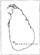
Figure 1 Location of Bulathsinhala DS division
It falls in the wet zone of the agroecological zone. The extent of the Bulathsinhala DS area is 212 sq.Km. It composed of 54 Grama Niladari (GN) divisions. An officer named as the " Grama Niladar" is assigned by the government for each of these divison to look after the administrative needs of the division.
3.0 GIS for Divisional Secretary Area
The main components that considered in establishing a GIS for Bulathsinhala was :
- User requirement Analysis
- Data modeling
- Spatial Analysis
In developing the development planning model, after discussion with officers attached to the division it was decided that there were three necessary inputs required for decision making. Those are
- The views of the government officers working in the DS area
- Views of the people and
- Views of the politicians
These were then analysed and weighted priority matrix was developed to obtain the priority requirements of the GN area. These requirements were then classified in to five groups. Those categorizations were the standard categories that adopted in development planning in Sri. Lanka such as
- Economic infrastructure requirements.
- Income and employment requirement.
- Social infrastructure improvements.
- Agriculture requirements.
- Human settlement requirements.
3.2 Data Model for the GIS
The selected geographic information were classified into classes and features type for structuring in the database. List of descriptors for individual feature type, quality parameter for each class also included in the data model.
As a physical model, ERSI's PC ARC/INFO software was used to establish GIS for pilot area. Topographic information was collected, digitized from the existing topographic maps. The spatial information layers in the GIS include administrative boundaries, roads, contour lines, landuse, soil significant places, powerlines and hydrology features.
All the non-spatial information are based on the GN division. Existing residential population, in terms of religion, ethnic ratio, number of households, level of poverty, level of education, employment status, sanitary and electricity facilities in terms of households are the demographic issues that included in the database.
The established Pilot GIS provides the means of defining area of interest and the particular view of data layers from which the users would like to access information. IDRISI & PC ARCVIEW also used for some functional analysis and querying. Both graphic and attribute information of an area can be retrieved via GN identification number.
3. Spatial Analysis
Road requirement is one of the priority requirement of the local level people in the bulathsinhala DS area. In this study, we have tried to solve this problem along with the spatial and non-spatial data in a GIS. This study was hypothetical and the criteria used was only taken as an exercise to see whether GIS could use in development planning.
In the problem identification study, four Grama Niladari Divisions identified their first priority requirement as the road requirement. Therefore, we have done the spatial analysis to satisfy this requirement. The road requirement of socio-economic, infrastures, landuse, soil and topography as factors.
3.3.1 Analysis Criteria for Route Identification
Population density was computed from the available data. When analyzing these values for identified four divisions, it was clear that to find a solution for their need is essential since these areas are highly populated.
From the Landcover layer cultivated terrain was excluded. But the low weigh was given to the selected cultivations. The selected landuse categories are
| Luse-suit | Landuse categories |
| 1. | Scrub, grass, sparsely used, other crop land |
| 2. | Tea, rubber, coconut open forest other perennial crop |
| 3. | Paddy |
Soil classification of that area was based on the terrain from and hence the suitable units were considered as
| Soil-suit | Soil categories |
| 1 | Flood plain association of mixed
alluvial soils, humic alluvial glay soils, humic alluvial glay soil
and half bog soils. Mountain ridges. Plateaus & valley low ridges association of RYP model Flat mixed alluvial soil. |
| 2 | Mountain ridges, high ridges &
mountain plateaus. Flood plains-erosion remnants. River and streams. |
The contour layer was processed to derive the slope layer for the area. Slope information was derived by importing the contour (vector) data to IDISHI software. The processing using IDRISI was based on raster data format.
Five different slope classes were used in relief classification as
| Slope % | Grid code | Terrain |
| 0-7 | 1 | Flat-undulation |
| 7-13 | 2 | Undulation |
| 13-20 | 3 | Undulation - steep |
| 20-55 | 4 | Steep |
| > 55 | 5 | Very steep |
Reservation area for streams and ela features was excluded from the hydrography layer. Hence, 40m and 15m buffer zones were created for stream and ela respectively. The major and minor roads in the existing road network also used in order to link the proposed road with the present infrastructure.
The study area was extracted including the 4 GN divisions which has their first priority requirement as road requirement. Then the landuse, soil, slope & hydrology layers interested with the study area. Individual layer information were then categories to meet the specification as mentioned above. Finally, the suitable area for road construction was obtained as
| Lusesuit | Soil suit | Gridecone | Suitability |
| 1 | 1 | 1 | 1 |
| 1 | 1 | 2 | 2 |
| 1 | 1 | 3 | 4 |
| 2 | 1 | 1 | 2 |
| 2 | 1 | 2 | 3 |
| 2 | 1 | 3 | 4 |
| 3 | 1 | 1 | 3 |
| Suitability | Description |
| 1 | Most Suitable |
| 2 | Suitable |
| 3 | Less Suitable |
| 4 | Not suitable |
Figure 2.0 shows the spatial analysis process for selection of suitable area for road construction.
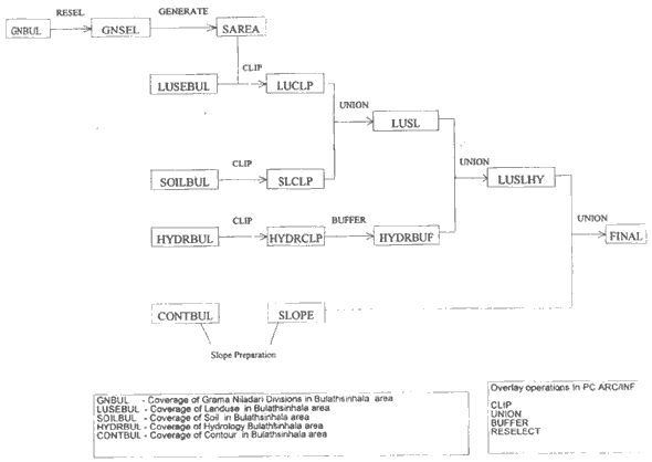
Figure 2 Flow Chart for Spatial Analysis
The suitable area (figure 5.0(a)) were then converted to raster format and friction values were given against the suitability. The starting point for the processed road was selected from the existing road network in order to generate a cost surface where cost is measured as the least effort in moving over the friction surface, and determine the least cost route from the cost surface. Minimum path analysis procedure is shown in figure 3.0.
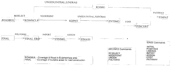
Figure 3 Minimum Path Analysis
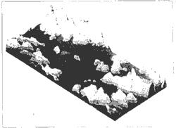
Figure 4 Relief of the study area
4.0 Results and conclusion
Esults of this s tudy shown in figure 5.0(b). It shows that the proposed road is linked with the existing road network and passes through the GN division. The identification of alternate routes also possible in this analysis.
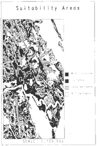
Figure 5.0 (a)

Figure 5.0 (b)
Our approach in implementing the pilot study is to create a database for DS level, develop well structure and organized data collection procedures and most importantly, encourage the planners to use spatial data for decision making. Although the case study is hypothetical, it shows that the capability of handing planers require requirement in a GIS environment. Furthermore, developed database allows more manipulate function through specific application while facilitating rapid decision making.
References :
- PC Arc/Indo Overlay users guide ver 3.4.2d Environmental Systems Research Institute, California
- ISRISI version 4.1, Ronald Eastman, Clark University. USA