| GISdevelopment.net ---> AARS ---> ACRS 1996 ---> Geoscience / DTM |
Assessment of Erosion in
Mountain Regions
Seyed Ahrmad Heydarian
Ministry of Jihad-e-Sazandagi Iran
Seyed Ahrmad Heydarian
Ministry of Jihad-e-Sazandagi Iran
Abstract
Soil erosion by water is one of the major soil degradation Processes in Iran.
Rangeland upland erosion estimation by using erosion and sediment models have been used in Iran since 1970. Common Models for example (PSIAC) developed by the pacific southwest Inter-agency committee, Universal Soil Loss Equation (USLE), Water Erosion Prediction Project (WEPP), Erosion Potential Method (EPM) etc. are used for erosion and sediment estimation.
In this research PSIAC is tested for Latian catchment, without and with the Geographic Information System (GIS). More Than 1700 Polygons are made by GIS instead of 19 subcatchments for 70000(ha) of Latian catchment, which could increase the capability of the model up to 20 percent.
Introduction:
Upland erosion from rangelands may seem relatively small compared to the very high rates reported for cropland areas. Rangeland erosion rates are very critical because of limited soil resource associated with many of the ecosystems involved and various physiographic Factor.
The relative importance of a range of physiongraphic factors influencing sediment yields can usefully by demonstrated by considering a methods of qualitatively rating the sediment yield. Potential of a drainage basin developed by the Pacific southwest Inter-agency Committee (PSIAC) (1968) for application to arid and semi arid areas in the southwestern USA. The rating technique involves nine factors (see Table 1) of which two are essentially concerned with climate and runoff characteristics, one reflects land use, and the remaining six factors introduce measures of geology, soil, vegetation and erosional development, Each of these factors is ratings is used to produce a sediment yield. In terms of individual factors, soils and surface geology are seen to possess similar importance (10 units), but are more important than soils and geology, while the two factors reflecting erosional development and conveyance characteristics assume the greatest importance (25 units).
The work of Johnson and Gebhart (1982) in refining the PSIAC model to provide a numerical basic for calculating the score rutings for individual factors (see table 2) provides a promising development of the PSIAC approach and represents a useful compromise between a regression equation and subjective rating.
Site introduce :
Latian catchment is located between the latitude 35' 45" to 36', 50" North and longitudes 51',22" to 51',51" East, The average annual precipitation throughout the catchment is 629 millimeters. The maximum temperature during Summer range from 38 degrees centigrade and minimum teiperature during the winder months is 23 below freezing points. The Latian catchment is mostly mountain type land ranging from 1500 m to 4000 meters in elevation from see level. All area of catchment drained toward the Latian Dam reservoir. The annual precipitation in the catchment averages 433 million cubic meters, and total annual renewable water resources of catchment are roughly assessed at 322 million cubic meters.
Application :
In this research the development of the PSIAC Model by two different Methods is undertaked. In first Method all physiographic factors are taken without using Remote Sensing and GIS, and overlaying the nine factors have been done by hand. In this case the catchment with 70000 (ha) is divided to 19 subcatchments, Therefore the averages charectristic of each factor are considered within the 19 subcatchments, and for each physiographic factor, average units are used (See table 3, Fig. 1), Hence a lot of mistakes taked into account. In Second Method most of physiographic factors are taken by Remote Sensign and with the aid of GIS, nine layer maps are overlayed. In this case the catchment is divided to 1700 homogenious polygons (with aid of GIS) (see fig. 2) and for each homogenious polygon PSIAC Model is used. With comparsion to real data (Hydrometry Data Analize) Remote sensing and GIS could increase the capability of the Model upto 20 percent.
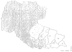
Figure 1: Latian Subcatchment
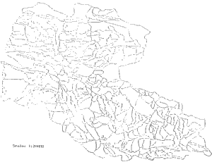
Figure 2: Latian Catchment Polygons
Conclusions
The evaluation of existing erosion and sediment Models in Mountain erase with variety f physigraphic characteristics without using remote sensing technique and GIS, not only is much difficult but also the estimations has no sufficient accuracy.
The Remote sensing with aid of the Geographic Information System (GIS), by creating much more homogenious polygosn, has sufficient accuracy for evaluation of Models.
References
Soil erosion by water is one of the major soil degradation Processes in Iran.
Rangeland upland erosion estimation by using erosion and sediment models have been used in Iran since 1970. Common Models for example (PSIAC) developed by the pacific southwest Inter-agency committee, Universal Soil Loss Equation (USLE), Water Erosion Prediction Project (WEPP), Erosion Potential Method (EPM) etc. are used for erosion and sediment estimation.
In this research PSIAC is tested for Latian catchment, without and with the Geographic Information System (GIS). More Than 1700 Polygons are made by GIS instead of 19 subcatchments for 70000(ha) of Latian catchment, which could increase the capability of the model up to 20 percent.
Introduction:
Upland erosion from rangelands may seem relatively small compared to the very high rates reported for cropland areas. Rangeland erosion rates are very critical because of limited soil resource associated with many of the ecosystems involved and various physiographic Factor.
The relative importance of a range of physiongraphic factors influencing sediment yields can usefully by demonstrated by considering a methods of qualitatively rating the sediment yield. Potential of a drainage basin developed by the Pacific southwest Inter-agency Committee (PSIAC) (1968) for application to arid and semi arid areas in the southwestern USA. The rating technique involves nine factors (see Table 1) of which two are essentially concerned with climate and runoff characteristics, one reflects land use, and the remaining six factors introduce measures of geology, soil, vegetation and erosional development, Each of these factors is ratings is used to produce a sediment yield. In terms of individual factors, soils and surface geology are seen to possess similar importance (10 units), but are more important than soils and geology, while the two factors reflecting erosional development and conveyance characteristics assume the greatest importance (25 units).
The work of Johnson and Gebhart (1982) in refining the PSIAC model to provide a numerical basic for calculating the score rutings for individual factors (see table 2) provides a promising development of the PSIAC approach and represents a useful compromise between a regression equation and subjective rating.
Site introduce :
Latian catchment is located between the latitude 35' 45" to 36', 50" North and longitudes 51',22" to 51',51" East, The average annual precipitation throughout the catchment is 629 millimeters. The maximum temperature during Summer range from 38 degrees centigrade and minimum teiperature during the winder months is 23 below freezing points. The Latian catchment is mostly mountain type land ranging from 1500 m to 4000 meters in elevation from see level. All area of catchment drained toward the Latian Dam reservoir. The annual precipitation in the catchment averages 433 million cubic meters, and total annual renewable water resources of catchment are roughly assessed at 322 million cubic meters.
Application :
In this research the development of the PSIAC Model by two different Methods is undertaked. In first Method all physiographic factors are taken without using Remote Sensing and GIS, and overlaying the nine factors have been done by hand. In this case the catchment with 70000 (ha) is divided to 19 subcatchments, Therefore the averages charectristic of each factor are considered within the 19 subcatchments, and for each physiographic factor, average units are used (See table 3, Fig. 1), Hence a lot of mistakes taked into account. In Second Method most of physiographic factors are taken by Remote Sensign and with the aid of GIS, nine layer maps are overlayed. In this case the catchment is divided to 1700 homogenious polygons (with aid of GIS) (see fig. 2) and for each homogenious polygon PSIAC Model is used. With comparsion to real data (Hydrometry Data Analize) Remote sensing and GIS could increase the capability of the Model upto 20 percent.
Figure 1: Latian Subcatchment
Figure 2: Latian Catchment Polygons
Conclusions
The evaluation of existing erosion and sediment Models in Mountain erase with variety f physigraphic characteristics without using remote sensing technique and GIS, not only is much difficult but also the estimations has no sufficient accuracy.
The Remote sensing with aid of the Geographic Information System (GIS), by creating much more homogenious polygosn, has sufficient accuracy for evaluation of Models.
References
- Bruwer, H.d. Introduction to Geographic Information
- Goldman, Steven J.Katharine Jackson, Taras A. Burxatynsky. PE. Erosion and sediment conrol Hand Book Mcgraw- Hill 1985.
- Hadley, R.F.R Lai; onstad, C.A. Walling, D.E., Yair, A Recent Developments in Erosion and Sediment Yield Studies, Unesco, 1985.
- Hor, John. A Introduction to Aerial photography, ITC Netherlands 1992.
- IAHS, Erosion Debris Flows and Environment in Mountain Regions 1992
- Walling, D.E. Recent Developmen in the Explanation and prediction of Erosion and sediment Yield, IAHS No. 137, 1982.