| GISdevelopment.net ---> AARS ---> ACRS 1996 ---> Geoscience / DTM |
Linear Feature Extraction
From SPOT Panchromatic Imagery
K.D. Parakum Shantha
Surveyor General’s Office
P.O. Box 506, Colombo
Sri Lanka
K.D. Parakum Shantha
Surveyor General’s Office
P.O. Box 506, Colombo
Sri Lanka
1.0 Introduction
Effective utilization of the vast amount of data produced by satellite imaging systems requires the use of automatic methods of image handing. The need for automatic and semi-automatic analysis is becoming acute with the increasing use of images for geology, land resource management, cartographic and military application.
In this context, an important step is image segmentation and identification of features in satellite images . A human interpreter can detect boundaries separating regions of different separating regions of different mean intensity. Automatic method rely on local statistics within some comparatively small mask and boundaries are detected by changes in the local statistics.
Sri Lanka is a developing country and it completed topographic maps at scale of 1:50,000 and map revision is the next task. There is a need for more efficient and cost effective methods for labour intensive map revision tasks particularly change detection. Hence, this study focused on the extraction of liner features in SPOT panchromatic imagery.
Therefore, the mutli-stage approach was established in the way that, enhancement of an image, different filtering techniques to extract linear features, visual detection of linear features from monitor screen and feature classification.
2.0 Data
The test area is located in the southern province of Sri Lanka. The cloud free SPOT pachromatic digital data of the test area was used in this study. The data was pre-processed by SPOT image cooperation. It included radiometric calibration and corrections for systematic geometric distortions.
3.0 Data analysis
The data analysis comprised four steps.
Image enhancement operations improve the appearance or quality of the digital image. Histogrm equalization method in contrast stretching is employed in this particular application.
The method use the image histogram directly in formulating contrast modification function. The purpose of this method is to level the image histogram as far as possible in order to assign equal number pixels to each integer pixel value. The pixel value transformation is taken directly from the cumulative frequency. An equalized image have a good spread of contrast and the enhanced image is shown in figure 1.0.
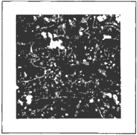
Figure 1 Enhanced Image
3.2 Feature Extraction
Feature extraction means segmentation of an image. Segmentation algorithms for monochrome images generally are based on basic properties of grey-level values: discontinuity. In this approach an image partition is based on abrupt changes in grey level.
There are three type of discontinuities in a digital image : point, line and edges. In this paper, in detection is being discussed.
Line detection means detection of the discontinuities in the digital image. the most common way to look for discontinuities is to run mask through the image. the procedure involves computing the sum of products of the coefficients with grey levels contain in the region encompassed by the mask. That is, the response of the mask at any point in the image is
R = w1z1 + w2z2 +
...... + w9z9 =å
wizi
Where Zi is the grey level of the pixel associated with mask coefficient wi. As usual, the response of the mask is defined with respect to its center location.
Masks which used to detected lines in the image as the first approach and result is shown in figure 2.0.
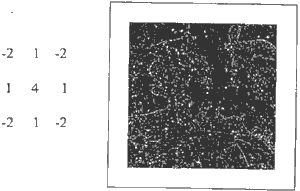
Figure 2 Orthogonal mask (From Frei and Chen, 1977) and resulted image
In the second approach, the following algorithm was applied.
The algorithm is :
BeginFor every (I,j) position on the image Do Take the 3x3 surrounding sub
image; Sort its 9 values in the array in the array Rank; Median = Rank
(5); Final image = Original image – Median; End.
Algorithm 1.0
The resulted image is shown in figure 3.0
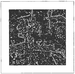
Figure 3 Results from algorithm 1.0
3.0 Visual Detection
Visual detection is the technique used by the image interpreter without applying automatic recognition methods, for the purpose of identifying object and judging their significance.
Visual interpretation of the semantic information are concerned in this issue. In this case, the nature of objects and identification of them is considered. The most fundamental characteristics which helps for that are : tone, texture, pattern, shape, size, shadow and situation. However, one has to bear in mind that is is not sufficient during interpretation. It needs also collateral material and field check.
Visually detected line features are shown in figure 4.0.
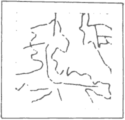
Figure 4 Visually interpreted image
4.0 Feature Classification
The extracted features are then to be classified in to different object types. This classification can be employed as:
(i) Using the specific knowledge about the objects.
This knowledge is generally based on the nature of the object. For example, if the nature of the objects are roads then the specific knowledge abut the roads are
This is generally based on the nature of the task. For an example, if the task is updating, it needs and extra knowledge abut the existing information. It gives,
the work presented here is only for small study area. Due to the time constraint, it was not possible to employ feature classification method as discussed in section 4.0 The result obtained from both algorithms show a similarity. However, results of this experimental work are encouraging and the method used, may be considered for updating of road network and hydrography features with the availability of high spatial resolution satellite images.
References
Effective utilization of the vast amount of data produced by satellite imaging systems requires the use of automatic methods of image handing. The need for automatic and semi-automatic analysis is becoming acute with the increasing use of images for geology, land resource management, cartographic and military application.
In this context, an important step is image segmentation and identification of features in satellite images . A human interpreter can detect boundaries separating regions of different separating regions of different mean intensity. Automatic method rely on local statistics within some comparatively small mask and boundaries are detected by changes in the local statistics.
Sri Lanka is a developing country and it completed topographic maps at scale of 1:50,000 and map revision is the next task. There is a need for more efficient and cost effective methods for labour intensive map revision tasks particularly change detection. Hence, this study focused on the extraction of liner features in SPOT panchromatic imagery.
Therefore, the mutli-stage approach was established in the way that, enhancement of an image, different filtering techniques to extract linear features, visual detection of linear features from monitor screen and feature classification.
2.0 Data
The test area is located in the southern province of Sri Lanka. The cloud free SPOT pachromatic digital data of the test area was used in this study. The data was pre-processed by SPOT image cooperation. It included radiometric calibration and corrections for systematic geometric distortions.
3.0 Data analysis
The data analysis comprised four steps.
- Enhancement of an image.
- Different filtering techniques to extract linear features
- Visual detection of linear features from monitor screen.
- Feature classification.
Image enhancement operations improve the appearance or quality of the digital image. Histogrm equalization method in contrast stretching is employed in this particular application.
The method use the image histogram directly in formulating contrast modification function. The purpose of this method is to level the image histogram as far as possible in order to assign equal number pixels to each integer pixel value. The pixel value transformation is taken directly from the cumulative frequency. An equalized image have a good spread of contrast and the enhanced image is shown in figure 1.0.
Figure 1 Enhanced Image
3.2 Feature Extraction
Feature extraction means segmentation of an image. Segmentation algorithms for monochrome images generally are based on basic properties of grey-level values: discontinuity. In this approach an image partition is based on abrupt changes in grey level.
There are three type of discontinuities in a digital image : point, line and edges. In this paper, in detection is being discussed.
Line detection means detection of the discontinuities in the digital image. the most common way to look for discontinuities is to run mask through the image. the procedure involves computing the sum of products of the coefficients with grey levels contain in the region encompassed by the mask. That is, the response of the mask at any point in the image is
| w1 | w2 | w3 |
| w4 | w5 | w6 |
| w7 | w8 | w9 |
Where Zi is the grey level of the pixel associated with mask coefficient wi. As usual, the response of the mask is defined with respect to its center location.
Masks which used to detected lines in the image as the first approach and result is shown in figure 2.0.
Figure 2 Orthogonal mask (From Frei and Chen, 1977) and resulted image
In the second approach, the following algorithm was applied.
The algorithm is :
Begin
The resulted image is shown in figure 3.0
Figure 3 Results from algorithm 1.0
3.0 Visual Detection
Visual detection is the technique used by the image interpreter without applying automatic recognition methods, for the purpose of identifying object and judging their significance.
Visual interpretation of the semantic information are concerned in this issue. In this case, the nature of objects and identification of them is considered. The most fundamental characteristics which helps for that are : tone, texture, pattern, shape, size, shadow and situation. However, one has to bear in mind that is is not sufficient during interpretation. It needs also collateral material and field check.
Visually detected line features are shown in figure 4.0.
Figure 4 Visually interpreted image
4.0 Feature Classification
The extracted features are then to be classified in to different object types. This classification can be employed as:
(i) Using the specific knowledge about the objects.
This knowledge is generally based on the nature of the object. For example, if the nature of the objects are roads then the specific knowledge abut the roads are
- Elongated objects with restricted and relatively constant width.
- Connected to a form of a network.
- Network consist of nodes and arcs.
This is generally based on the nature of the task. For an example, if the task is updating, it needs and extra knowledge abut the existing information. It gives,
- The location of the old situation.
- Properties of objects.
the work presented here is only for small study area. Due to the time constraint, it was not possible to employ feature classification method as discussed in section 4.0 The result obtained from both algorithms show a similarity. However, results of this experimental work are encouraging and the method used, may be considered for updating of road network and hydrography features with the availability of high spatial resolution satellite images.
References
- Frei, W. and Chen, C.C. (1977). “Fast Boundary Detection: A Generalization and a New Algorithm. “IEEE Transaction Computer, vol. C-26.
- Rafael, C.G. and Richard, E.W., (1992). “Digital Image Processing. “ISBN 0-201-60078-1, Addison –Wesly Publishing Company.
- Bill, S., Jianying Hu, Theo Pavlidis, (1993) “Computer Assisted Tracing Of Fint Roads in Satellite Image.”, ACSM/ASPRS Annual Convention, New LA.