| GISdevelopment.net ---> AARS ---> ACRS 1996 ---> Geoscience / DTM |
Hydrological Investigations
In Gangetic Basin Using Remote Sensing And Basement DEM - A Case Study
Ajay Srivastava, Nitin Kumar Tripathi and K.V.G.K. Gokhale
Department of Civil Engineering
Indian Institute of Technology, Kanpur- 208016, India.
Ajay Srivastava, Nitin Kumar Tripathi and K.V.G.K. Gokhale
Department of Civil Engineering
Indian Institute of Technology, Kanpur- 208016, India.
Abstract
An attempt is made to evolve an integrated approach to groundwater exploration in the Genetic alluvial terrain in terms of aquifer targeting and groundwater quality assessment using remote sensing data one hand and the geological, geomorphological and basement topographic data on the other. The area chosen for a chase study is around Banda (Uttar Pradesh, India). The geological sequence is of clay - sand (and gravel) deposited on an irregular granite basement. Two difference types of basement depressions are present in the study area which affect groundwater potential and quality differently. In the present study the geological, geomorpholocical and structural aspects of the terrain have been worked out based on the digital image processing of IRS-1B LISS II data. Digital elevation model (DEM) of the basement topography has been prepared by conversing set of depth to bedrock contours to another set of contours. An overly of the enhanced image on to the DEM of the basement has clearly brought out the effect of subsurface features on the geomorphological and aquifer geometry. Variation in tone and texture associated with vegetation and geological futures coupled with inferred groundwater migration pattern in the s toddy area have enabled the delineation of the brackish groundwater pockets which are in close agreement with the field investigation.
1.Introduction
A detailed study of the various subdivisions of the morphological units e.g., abandoned channels, flood plains, braided streams, sand bars and varies mapped on the basis of geometric from, nature of boundary and tone, leads to an understanding of the hydrogeological framework of the region. The aim of the present work is to search the sites of buried and abandoned channels and mapping of other geomorphic features in the inter-drainage areas to provide a complete hydromorphic picture of the area.
The application of GIS in the groundwater exploration has yet to be fully exploited. The use of DEM for 3D visualization and terrain draping, thematic map overlays can be very helpful in the interpretation of remotely sensed data. Previously, subsurface geomorphological features such as buried channels have been identified in the Gangetic plain using remotely sensed data (Gautam, 1990). Since most of the geological extend deep down into the Earth, as well as across it, the three dimensional spatial nature of geological features needs special attention. This type of representation is especially useful if the intention is to demonstrate the relationship between basemen topography and surface features to identify the groundwater recharge zones.
Geology and Subsurface Details of the Study Area
The area chosen for the study is located in the Banda district of Uttar Pradesh, India, with an average altitude of 117.5 m adobe mean sea level. The terrain is flat with occasional hillocks. River Ken is the man in drainage flowing in a northerly direction. The lateral extent of aquifers at various depths in the Gangetic Alluvial Terrain is controlled by the palaeo channel trends during Pleistocene-Holocene period. The aquifers, composed of sand silt combination's represent the channel deposits of the ever shifting drainage network with vast flood plains (Bajpai, 1986). The aquifers show a wide variation in their nature and geometry from place to place, which is the result of the variations in the basement topography and localized changes in its depth due to displacements along weak zones. In the study area, a thich sand body (upto 60 m) with its trend parallel to the course of the river Ken has been reported earlier (Bajpai, 1986). This sand body occupies the central part of a graben (maximum dept 89m and designated as 'Ken graben' by earlier workers) and tapers in thickness both n the lateral as wells in the longitudinal directions. The sand body appears to have its recharge from the elevated areas in the sough with hydraulic conductivity restored through intermittent sand lenses at various depths. These bedrock depressions which are very common in this region, were once setting basins for the inflowing water courses. Such buried channel deposits are the potential source of groundwater.
In the southern part, exposures of weathered grantic material are evidenced. Another depression lies between the inter river basin of Ken and Baghain rivers in this region. The depth varies between 20m to 105m in the region and it increase further south (Bhattacharya, 1984). According to Ahmad (1984), this inter river basin possibly was formed due to large scale structural dislocations perhaps in the post Vindhyan period resulting into a 'mini graben'.
3.Methodology
In the present study IRS-1B LISS2 image in 4 bands have been utilized. Several image processing and GIS techniques have been adopted for extracting maximum hydrogeological information. ILWIS 1.41 GIS and Image processing package has been utilized. The FCC of principal components, contrast enhancement, directional edge detection techniques have yielded useful hydro-geomorphic information. These output images were further used for generation of digital elevation model of basement topography (Fig. 1) using GIS tools such as image georeferencing elevation interpolation and image draping. The reference field data of basement elevation has been utilized for the DEM (Ahmad, 1984; Murty and Srivastava, 1990). The mati map for groundwater characterization are prepared on 1:20,000 scale, depicting remote sensing keys. The remote sensing keys used for aquifer detection using satellite image were local and regional relief setting, stream valleys, vegetation indices of moisture anomalies, alluvial plains, flood, plains, alluvial fans, braided and meandering streams related to shallow groundwater levels, braided and meandered plain, channel-fill, orientation of lineaments, fractures, geologic barriers like dykes, drainages network, weathered zones, orientating of ponds and takes use and land cover.
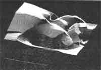
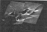
Figure 1 DEM of the basement topography around Banda and Naraini
4.0 Landform Analysis
Regional and local geomorphology is well depicted by satellite images. Based on the remote sensing keys, the area has been divided into five major geomorphic units with their associated landforms.
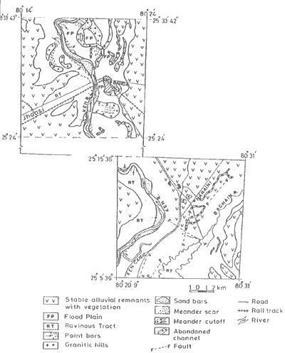
Figure 2 Hydrogeomorphological map of the study area
5.Groundwater Potential
The gemorphological study of the area alongwith the reconstructed palaeosurface topography has shown that the area holds promose for future development of groundwater. ON this basis, following conclusions are made,
6.Conclusions
This study has established that remote sensing and GIS techniques can be successfully applied for the regional investigations of the groundwater recharge zones. It may be indicated that the most remarkable areas of groundwater availability correspond to the commonly occurring depressions in the bedrock. The subsurface morphology of the basin and the tectonics are the factors which influenced the sedimentation pattern and guided the channels of Yamuan rive system. These depressions domed the site of intensive deposition of coarse gravel and coarse sand due to rapid erosion of the material from adjacent regions and subsequent transportation to the favorable sits. The low gradient of near surface water table, thin sand bed beneath a thick clay layer the Banda region and the related discharge from the neighboring areas resulting in an immigration of groundwater and an increased amount of dissolved salts towards the Ken graben area have all contributed to the groundwater salinity in the northern part of the study area. This problem willfurhte aggravate with time as more salt will accumulate with inflow of groundwater in the future. But I n the southern part of the study area the salinity problem is not encountered due to presence of thick sand below the upper clay horizon and a relatively steeper gradient of water table around Naranini 'mini gradben' region.
Acknowledgement
Authors are grateful to the officials of Central Groundwate Board, Northern Region, India, for providing the access to their library for the ground truth and borethole data.
Reference
An attempt is made to evolve an integrated approach to groundwater exploration in the Genetic alluvial terrain in terms of aquifer targeting and groundwater quality assessment using remote sensing data one hand and the geological, geomorphological and basement topographic data on the other. The area chosen for a chase study is around Banda (Uttar Pradesh, India). The geological sequence is of clay - sand (and gravel) deposited on an irregular granite basement. Two difference types of basement depressions are present in the study area which affect groundwater potential and quality differently. In the present study the geological, geomorpholocical and structural aspects of the terrain have been worked out based on the digital image processing of IRS-1B LISS II data. Digital elevation model (DEM) of the basement topography has been prepared by conversing set of depth to bedrock contours to another set of contours. An overly of the enhanced image on to the DEM of the basement has clearly brought out the effect of subsurface features on the geomorphological and aquifer geometry. Variation in tone and texture associated with vegetation and geological futures coupled with inferred groundwater migration pattern in the s toddy area have enabled the delineation of the brackish groundwater pockets which are in close agreement with the field investigation.
1.Introduction
A detailed study of the various subdivisions of the morphological units e.g., abandoned channels, flood plains, braided streams, sand bars and varies mapped on the basis of geometric from, nature of boundary and tone, leads to an understanding of the hydrogeological framework of the region. The aim of the present work is to search the sites of buried and abandoned channels and mapping of other geomorphic features in the inter-drainage areas to provide a complete hydromorphic picture of the area.
The application of GIS in the groundwater exploration has yet to be fully exploited. The use of DEM for 3D visualization and terrain draping, thematic map overlays can be very helpful in the interpretation of remotely sensed data. Previously, subsurface geomorphological features such as buried channels have been identified in the Gangetic plain using remotely sensed data (Gautam, 1990). Since most of the geological extend deep down into the Earth, as well as across it, the three dimensional spatial nature of geological features needs special attention. This type of representation is especially useful if the intention is to demonstrate the relationship between basemen topography and surface features to identify the groundwater recharge zones.
Geology and Subsurface Details of the Study Area
The area chosen for the study is located in the Banda district of Uttar Pradesh, India, with an average altitude of 117.5 m adobe mean sea level. The terrain is flat with occasional hillocks. River Ken is the man in drainage flowing in a northerly direction. The lateral extent of aquifers at various depths in the Gangetic Alluvial Terrain is controlled by the palaeo channel trends during Pleistocene-Holocene period. The aquifers, composed of sand silt combination's represent the channel deposits of the ever shifting drainage network with vast flood plains (Bajpai, 1986). The aquifers show a wide variation in their nature and geometry from place to place, which is the result of the variations in the basement topography and localized changes in its depth due to displacements along weak zones. In the study area, a thich sand body (upto 60 m) with its trend parallel to the course of the river Ken has been reported earlier (Bajpai, 1986). This sand body occupies the central part of a graben (maximum dept 89m and designated as 'Ken graben' by earlier workers) and tapers in thickness both n the lateral as wells in the longitudinal directions. The sand body appears to have its recharge from the elevated areas in the sough with hydraulic conductivity restored through intermittent sand lenses at various depths. These bedrock depressions which are very common in this region, were once setting basins for the inflowing water courses. Such buried channel deposits are the potential source of groundwater.
In the southern part, exposures of weathered grantic material are evidenced. Another depression lies between the inter river basin of Ken and Baghain rivers in this region. The depth varies between 20m to 105m in the region and it increase further south (Bhattacharya, 1984). According to Ahmad (1984), this inter river basin possibly was formed due to large scale structural dislocations perhaps in the post Vindhyan period resulting into a 'mini graben'.
3.Methodology
In the present study IRS-1B LISS2 image in 4 bands have been utilized. Several image processing and GIS techniques have been adopted for extracting maximum hydrogeological information. ILWIS 1.41 GIS and Image processing package has been utilized. The FCC of principal components, contrast enhancement, directional edge detection techniques have yielded useful hydro-geomorphic information. These output images were further used for generation of digital elevation model of basement topography (Fig. 1) using GIS tools such as image georeferencing elevation interpolation and image draping. The reference field data of basement elevation has been utilized for the DEM (Ahmad, 1984; Murty and Srivastava, 1990). The mati map for groundwater characterization are prepared on 1:20,000 scale, depicting remote sensing keys. The remote sensing keys used for aquifer detection using satellite image were local and regional relief setting, stream valleys, vegetation indices of moisture anomalies, alluvial plains, flood, plains, alluvial fans, braided and meandering streams related to shallow groundwater levels, braided and meandered plain, channel-fill, orientation of lineaments, fractures, geologic barriers like dykes, drainages network, weathered zones, orientating of ponds and takes use and land cover.
Figure 1 DEM of the basement topography around Banda and Naraini
4.0 Landform Analysis
Regional and local geomorphology is well depicted by satellite images. Based on the remote sensing keys, the area has been divided into five major geomorphic units with their associated landforms.
- Recent flood plain of Ken and its tributaries containing point bars, channel bars and sand bars.
- Ken alluvial surface comprising of palaeo channels, menader cutoffs, meander scrolls.
- Stable alluvial remnants with dense vegetation.
- Ravinous tract along Ken and its tributaries.
- Low structural-cum denudational hills.
Figure 2 Hydrogeomorphological map of the study area
5.Groundwater Potential
The gemorphological study of the area alongwith the reconstructed palaeosurface topography has shown that the area holds promose for future development of groundwater. ON this basis, following conclusions are made,
- The area is almost plain except some isolated granitic hillocks and the part of natural levees, point bars and flood plain. It is made up of unconsolidated deposits of Indogangetic alluvium of recent age comprising clay, silt, Kankar, sand and their admixtures of various grades.
- About more than one-third of the Banda area is covered by prominent features such as, meander scroll, abandoned channels, natural levee, flood plain, point bar deposits and rest is covered by stable alluvial remnants.
- Alluvial plain area is hydrogeologically a potential region for the development of groundwater resources.
- Point bar area is much better and promising for the development of groundwater works depending upon location and suitability in respect f flood recurrence.
- Although food plain area if self is a highly moistures contained installation of permanent and heavy groundwater structures is not recommended due to frequent flood hazards.
6.Conclusions
This study has established that remote sensing and GIS techniques can be successfully applied for the regional investigations of the groundwater recharge zones. It may be indicated that the most remarkable areas of groundwater availability correspond to the commonly occurring depressions in the bedrock. The subsurface morphology of the basin and the tectonics are the factors which influenced the sedimentation pattern and guided the channels of Yamuan rive system. These depressions domed the site of intensive deposition of coarse gravel and coarse sand due to rapid erosion of the material from adjacent regions and subsequent transportation to the favorable sits. The low gradient of near surface water table, thin sand bed beneath a thick clay layer the Banda region and the related discharge from the neighboring areas resulting in an immigration of groundwater and an increased amount of dissolved salts towards the Ken graben area have all contributed to the groundwater salinity in the northern part of the study area. This problem willfurhte aggravate with time as more salt will accumulate with inflow of groundwater in the future. But I n the southern part of the study area the salinity problem is not encountered due to presence of thick sand below the upper clay horizon and a relatively steeper gradient of water table around Naranini 'mini gradben' region.
Acknowledgement
Authors are grateful to the officials of Central Groundwate Board, Northern Region, India, for providing the access to their library for the ground truth and borethole data.
Reference
- AHMAD, S.M., 1984, Hydrogeological investigation for augmenting water supply in drogutht affected areas of Banda District U.P., India Report of the Central Groundwater Board, India.
- BAJPAI, V.N. and GOKHALE, K.V.G.K., 1986, Hydrogeological characterists of marginal Gangetic alluvial plain in Uttar Pradesh. Journal of Geological Society of India, 28,pp9-20.
- BHATTACHARYA, S.C. 1984, Report on Systematic Hydrogeological Surveys in part of Hamirrpur,, Banda and Fatehpur District of U.P., India. Report of the Central Groundwater Board, India.
- GAUTAM, A.M. 1990, Application of IRS-1A Data for Delineating Buried Channels in Southern Part of Allahabad District of Uttar Pradesh , Journal of the Indian Society of Remote Sensing, Vol. 18, No 3, 1990, pp 52-55.
- MURTY, C.D. and SRIVASTAVA, J.B. 1990, Feasibility report for drilling of tube wells for augmentation of water supply to Banda city, U.P., India Report of the Remote Sensing Application Centre, U.P. India.