| GISdevelopment.net ---> AARS ---> ACRS 1996 ---> Forestry / Vegetation |
The Environmental Remote
Sensing Monitoring and Research of JAINFENG Mountain Country Forest Park
in HAINAN
Li Xuexian
The Bureau of Meteorology of Hainan Province
60 Haifu Road, Haikou, Hainan Province, China
P.C. 57023 Tel: (86)898-5350300
AbstractThe Bureau of Meteorology of Hainan Province
60 Haifu Road, Haikou, Hainan Province, China
P.C. 57023 Tel: (86)898-5350300
Felling much tropical primeval forest exerts a tremendous influence to the ecological environment, and it can't make us optimistic, causes the danger of exhaustion to the tropical forest resources that aren't rich at first. In order to protect the precious heritage and organic gene pool, except that the administration strengthen execution of the law, the timely and precise monitoring of the tropical forest is a very important work, and the high effective work must be finished by remote sensing technology.
1. Introduction
Because of the special geographical environment, the Hainan Island still retains a small number of tropical primeval forest so far. Before 1938, the tropical primeval forest covered 46% of the Hainan Island. Because of being robbed by Japanese during the Second World 46% of the Hainan Islant. Because of being robbed by Japanese during the Second World war and the Chinese faults on the policy of the forestry and the agriculture after the liberation, the massive organic gene pool and headwaters conservation locality decreased by 99.96% in the past half a century and more. According to the interpretive results of the Landsat materials in Feb. 24,1994, there were 12 tropical primeval forests in the island now, about 64,307.64 hectares, covered 1.89% of the island. There were still 8,175.70 hectares' natural primeval forest (including the natural reserve) at the Jianfeng Mountain Country Forest Park renowned at home and abroad by the end of 1994, it had already been less than 18.45% of the whole forest region. It's still crucial to supply the information of monitoring for the government's departments promptly and precisely by the advanced modernized means, although the government have given order to stop any felling to the natural primeval forest geographical coordinates are 18°38'~18°50'N and 108°45'~109°03'E, the whole are is 447.33 km2. The regional landforms are mainly hills, low mountain, middle mountain, the summit of the mountain, the jainfeng Peak is 1412.5 meters above sea level. The river system converges to sea mainly in the shape of radiation, taking the Jainfeng Mountain as the center, the rivers are short, the riverbeds have large drops, the rivers suddenly rise or fall. There are usually 3~5 months of low water period in dry season, the rivers' upper reaches dry u further. There are water flow low only in the parts of the rivers in the primeval forest region throughout the year. Both the ground regulative functions and the bedrock's water-bearing properties are worse in the whole catchments region.
The Jainfeng Mountain belongs to the low latitudes area, tropical monsoon climate, warm or hot throughout the year, the average air temperature of 24.5 a year, the same of 19 in the coolest month, the absolutely lowest air temperature of 2.5 no forest and snow. A year is divided into the dry and wet season, the clear characteristics of rainforest climate, the 80~90% rainfall concentrates in the 5~10 months, specially in 8~10 months. The average rainfall is 1600~2600 mm per year, it's the region that have more rainfall in China.
2. The Technological Routes and the Informational Source
We selected the forest region's American Lansat~5 TM data that had nearly the same temporal in the three years of 1992~1994, conducted the image expansion, the precise geometric correction, the classification, the interpretation, the field verification and other operation. The concrete technological routes are as the figure 1.
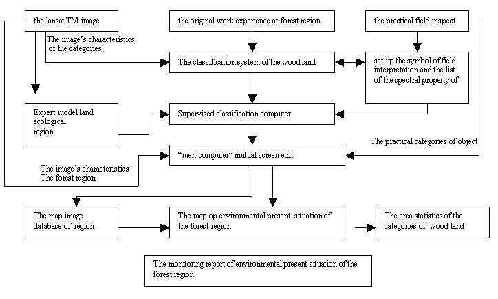
Figure 1. The work's flow diagram of the wood Land's environmental remote sensing monitoring of JianFeng mountain country forest park
The work's informational types consisted of three parts, they were the Landsat TM data, the investigative and verified data about the forest region, the statistic, observational and visitant figures from the Bureau of Forestry of the Jainfeng Mountain and other departments. The TM data source was the informational kernel of the work. The work belonged to the item of environmental dynamic monitoring, the key of success or failure was the historical and up-to-data Landsat data which must have high quality and high resolution at the work. Because it's almost cloudy above hainan Island every day, the margin of selecting the data was so limited (The American Lansat-5 cover frequency is 23 times per year above hainan Island, there is hardly any selective margin if we want to get the data in different years which have the same temporal). We selected American Lansat-5 TM data as the main data source which had no cloud or less cloud on Nov. 1, 1992 (representing 1992), Feb. 24, 1993 (representing 1993) and Dec. 25, 1994 (representing 1994) at the work.
3. The Classificatory Principle by Computer on the Forest land the Analysis of the Spectral property of Object.
1) The Classification Principle and Method
The main purpose was environmental monitoring at the forest region, the main investigative and statistic object was the dynamic change of the every types of wood land and environmental destruction at this work. On these grounds, we divided the objects at the forest region into 15 categories according to the possibility of the remote sensing technology and the system software at present and the assignment and requirement, taking spectral combinative property of object as the main classificatory basis and principle. (As table 1, classification property of object as the main classificatory basis and principle. (As table 1, classification of wood land). In order to set up the nearly unified standard of brightness value.
Table 1
| The table of statistics
and contrast of the present situation's area of wood land's category
at the JianFeng Mountain Country Forest Park of Hainan in 1992/ 1993 and 1994 | |||||||||
| No. | the categories of objects | Nov. 1, 1992 | Feb. 24, 1994 | Dec. 25, 1994 | Compare to 1992 | ||||
| hectares | percentage | hectares | percentage | hectares | percentage | Increase | Decrease | ||
| 1 | Quasi-primeval forest | 9927.93 | 22.41 | 9252.23 | 20.88 | 8175.70 | 18.45 | 3.96 | |
| 2 | Better secondary forest | 8054.51 | 18.19 | 7339.37 | 16.55 | 5770.57 | 13.02 | 5.17 | |
| 3 | Medium secondary forest | 13542.70 | 30.58 | 13045.08 | 29.43 | 10240.23 | 23.11 | 7.47 | |
| 4 | Inferior secondary | 7379.34 | 16.65 | 10224.64 | 23.08 | 11699.63 | 26.41 | 9.76 | |
| 5 | Sparse tree shrubs | 1118.48 | 6.07 | 2644.62 | 5.97 | 5583.94 | 12.60 | 6.53 | |
| 6 | Man-planted forest | 2690.59 | 2.52 | 736.46 | 1.66 | 852.45 | 1.92 | 0.60 | |
| 7 | Grassland | 1118.48 | 0.70 | 63.37 | 0.14 | 561.80 | 1.27 | 0.57 | |
| 8 | From land | 3212.18 | 0.07 | 65.08 | 0.14 | 117.94 | 0.28 | 0.21 | |
| 9 | Heavily fired word land | 386.81 | 0.87 | 312.58 | 0.71 | 489.47 | 1.10 | 0.23 | |
| 10 | Lightly fired wood land | 370.38 | 0.83 | 370.53 | 0.84 | 131.29 | 0.30 | 0.53 | |
| 11 | Heavily naked land | 40.51 | 0.09 | 13.63 | 0.03 | 63.29 | 0.14 | 0.05 | |
| 12 | Lightly naked land | 311..33 | 0.70 | 116.62 | 0.26 | 444.42 | 1.00 | 0.30 | |
| 13 | Quarry | 4.40 | 0.01 | 4.51 | 0.01 | 27.18 | 0.06 | 0.05 | |
| 14 | Water body of humid land | 45.63 | 0.21 | 17.87 | 0.04 | 35.76 | 0.08 | 0.02 | |
| 15 | Settlement | 92.77 | 0.21 | 100.55 | 0.26 | 113.86 | 0.26 | 0.05 | |
| Total | 44307.40 | 100 | 44307.14 | 100 | 44307.44 | 100 | |||
we tried to make the image's brightness value in different years nearly consistent at the operations of image expansion, regarded the nearly unified average spectral brightness value of the years and the combinative property from examination as the main classificatory index. Secondly, we also emphasized the form's formative factors' classificatory principle, the landforms' formative factor's classificatory principle and the environmental background value classificatory principle, making them as one part of the whole classificatory principle and the classificatory index system. For example the natural primeval forest, first we took the Lansat image on dec. 1, 1992 as the consultative original manuscript, set up the expert model according to the classificatory principle, and then set up the unified interpretative standard. There was excessively more difference about the spectral property between the natural primeval forest and the perennial secondary forest, the difference was the former have its specific characteristics in the district, wood land environment and the geometric properties of map spot, we worked out the follow model standard in view of the above.
- Made the interpretative model according to the work experience at the forest region, the spectral combinative properties of the natural primeval forest, geometric properties characters and territorial environmental properties.
- The model's requirement was that the map spots of primeval forest (or the perennial secondary forest) must cover more than 80% of the whole map spots' area.
- The felled traces in the in the map sports were less than 5% (Band combination of TM7, TM4, TM3, spectral radiative values are 60, 156 and 12~60 in proper order), in other world, no clear felled traces.
- The map spots must have a certain standard, the single map spot's area was more that 40 hectares (20 x 20 pixels).
- The map shots, which was not qualified for the primeval forest and had TM7, TM4, TM3 spectral brightness values of 12, 60, 12~60 were all incorporated into the perennial secondary forest that recovered better.
- For the other object categories we set up the train sample area at the known area, made the thematic classificatory map by the method of supervised classification, and conducted the edit, the changing values, and the statistics of merged area consulting the classificatory principle for the classificatory map, then filtered the tiny map spots less than 15 pixels, making the map terse and sprightly.
2) The Analysis of the Spectral Property
All of the objects have their own particular spectral reflecting and radiating properties. The emissive and absorbing actions of material electromagnetic wave are caused by the vibration of atoms, the rotation of molecules and the transitions of energy level of electrons, they all are the least corpuscles that constitute material. The change from the high energy state to low energy state can release energy and radiate certain wavelength's electromagnetic wave, the change from low energy state to high energy state can absorb reflecting electromagnetic wave themselves, and we can recognize the different of spectral property of electromagnetic wave that is received by remote sensing instrument. The work's informational source was lansat-5TM data, we analyzed the spectral properties of the different categories of wood land from TM1 to TM7 and except TM6 (as figure 2). Obviously, the reflecting spectral curves of the different categories of objects changed evidently according to figure 2, especially at TM4 (0.76~0.90mm) the change showed the most outstanding. The spectral reflectance of the quasi-primeval forest(1) and the medium secondary forest(2) were both less than 50% at TM4, that not only represented the spectral properties of the health plant itself, but also represented that it related to higher canopy density of the wood land and higher moisture
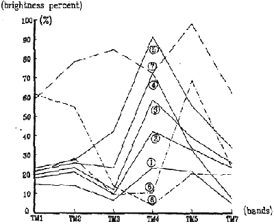
(1)Represent the quasi-primeval forest (2)Represent the medium secondary forest (3) Represent the inferior secondary forest (4) Represent the shrubs (5) Represent the grassland (6) Represent the heavily fired wood land (7) Represent the heavily naked land (8) Represent the water body
Figure 2. The Spectral Reflectance of the Main Objects at the Forest Region at the Jianfen Mountain.
content of plant. The vegetation type transited grassland from wood land along with the increasing spectral reflectance. After researching the reflecting spectral properties of different plant W.D. Billin and R.J. Morris held that the habitat conditions of plant were drier, the reflectance higher. The practice proved that the reflectance of herbaceous herb or broad-leaved herebaceous herb(5) was the highest at TM4 (Not got rid of the influence of naked earth background which had high brightness value), reaching more than 90% the reflectance of the shrubs(4)and the inferior secondary forest (3) (Mainly belonged to broad-leaved forest, 3-5 grades of wood) took the second place between 50~80. Generally, the average reflectance of the deciduous broad-leaved plant group was 50~80% higher than that of the evergreen broad-leaved plant group (including the narrow-leaved plant group) at TM4, the reflectance of big-leaved tree species was higher than that of the narrow-leaved tree species. The naked land, the lightly naked land and the shadow all showed the maximum reflectance and the minimum at the different bands because of no vegetation or being unable to represent the vegetation in them, the reflectance of other objects, such as the water body, the water field and the primeval forest etc., decreased along with increasing moisture content.
The TM3 (0.63~0.63mm) is the strongly absorbed zone of chlorophyll. the chlorophyll in plant body have four formations of a,b,c, and d, the influence of the reflecting spectral curves of the chlorophyll a and b is main and larger considering their quantity and action. In the absorbing action of the chlorophyll a is the most strong at 0.68~0.70mm. When chlorophyll assimilate a molecule of carbon dioxide (CO2), it releases a molecule of oxygen (O2), requiring absorbing 8 light quantum the total absorptive can reach about 90%, so the formation of trough take shape at 0.68~0.70mm. The absorptive to light of plant drop suddenly along with rising wavelength from 0.68mum.
The reflecting spectral curves of plant show low or medium quantity of reflectance at TM7 (2.08~2.35mm), the characteristic relates to the spectral properties of the plant and its moisture content. For example, the water body and forest land were both the land categories of lower reflectance (the reflectance was between 5~34%), according to the law, we arranged the plant species and groups of different moisture content and canopy density again, representing audio-visually combinative characteristics of vegetation type wood land again.
The representation to non-forest land was audio-visual at TM5(1.55~1.75 mm), especially, the reflectance of heavily, lightly fired wood land, heavily, lightly naked land and quarry was more evident than that at TM3, TM4 and TM7.
Through the above-mentioned spectral analysis, after the combinative experiment of the TM5(R), TM4(G), TM3(B) represented classificatory characteristics of vegetation of vegetation in the region best, especially the former combinations. In color composite, we broke the composite scheme of the followed conventional false color scheme of TM4®, TM7(G), TM3(B). The result showed under the premise of no losses of image information, the use of the simulated natural color not only tallied with the visual habit of the men's eyes, but also was very advantageous to classification and interpretation.
The Statistics and Analysis of the Category of the Wood Land
1) The Contract of the Category of the Wood Land
In order to represent the various area quantities of the different categories of the word land, we took the statistics of area, listed the various area quantities of the different categories of wood land and the results of contrast in the different years in the table 1.
The Analysis of the Present Situation of the Wood Land
The primeval forest (except the reserve) remained only at the precipitous area of middle mountain in the north of the forest region before stopping to fell it in 1993, the natural primeval forest was still relatively integrated as a whole although its margin zone had large area of felling spot. The large area of naked land and fired wood land were caused by reclaiming wasteland and opening up a field, burning the forest and hunting or the renewal of artificial slash near the different tree farms and in the margin of the primeval forest. Among them the total area of "the four used land" of the farm land, the fired wood land, the naked land and the quarry reached 1,43,23 hectares.
The felling was stopped at the forest region in 1993. The area generally kept the level of the slightly. But the destruction of margin zone of the forest region intensified obviously, the spots of felling increased double, the natural primeval forest decreased 675.7 hectares uncentrated and opening up a field at the different tree farms in the south of the forest region. the total are of "the four used land" was 882.95 hectares in the forest region.
A large area of fired wood land appeared again except that the felling intensified further in addition, there was also felling activity in varying degrees at the distinct tree farms of the developing the agriculture at the tree farms in the south of the forest (region). In the whole four used land" was 1,273.5 hectares. Moreover, the area of land using for building increased n varying degrees.
The practice proved that monitoring and researching the forest environment by the remote sensing technology was a kind of many, quick, good, sparing advanced mean undoubtedly. the work lasted 4 months (3 months' effective work), we probed and got a whole set of effective work method.
Reference Literature
- Chen Shupeng etc., 1990 < < Geoanalysis of Remote Sensing>>, The Survey and Drawing Publishing House.
- Jiang youxu etc., 1991, < < The Ecosystem of the Tropical Forest at the Jianfeng Mountain in the Hainan Island in China>>, The Science Publishing House
- Lixuegian, 1992, < < The Remote Sensing Working out Map Reparot of Land use Present Situation at the Jianfeng Mountain Region in Hainan Province>>