| GISdevelopment.net ---> AARS ---> ACRS 1996 ---> Forestry / Vegetation |
Classification of
Multi-sensor Data using a combination of Image Analysis
Techniques
Gerrit Huunemna, Lucas
Broekema
International Institute for Aerospace Survey and Earth Sciences (ITC)
Department of Geoinformatics
P.O. Box 6, 7500 AA Enschede, The Netherlands
Tel. +31-53-4874489, Fax. +31-53-4874335
E-mail: HUURNEMAN@ITC.NL
AbstractInternational Institute for Aerospace Survey and Earth Sciences (ITC)
Department of Geoinformatics
P.O. Box 6, 7500 AA Enschede, The Netherlands
Tel. +31-53-4874489, Fax. +31-53-4874335
E-mail: HUURNEMAN@ITC.NL
Most image analysis techniques have both strong and weak aspects. Training a complex neural network of image classification, for example, is a time-consuming process. Using a conventional classifier (e.g. maximum likelihood) in combination with a neural network classifier can reduce processing time while, at the same time, reinforcing the performances of both classifiers..
This paper deals with the classification of an area where the land use is mainly agriculture, with optical and microwave data as input. The optical data is acquired by the SPOT satellite in multi-spectral mode and the microwave data is acquired by the ERS-1 and ERS-2 satellites in single look complex mode. in the first step of the classification, the maximum likelihood classifier is used; the classes that are classified satisfactorily are masked out and the remaining data is classified within a reduced neural network. the results of the classifications of several data combinations are monitored. The influence of the mode in which the microwave data is used in these combinations is especially highlighted (intensity images versus coherence maps).
The coherence map is created based on the correlation of two complex SAR data sets. Indication the level of (de) correlation, this map gives information about the relation between groundcover and temporal changes. For classes that cannot be separated with optical data alone an investigation is made into the use of such (de) correlation as an additional layer.
Introduction
With the launch of every new sensor system for the acquisition of data in the optical and /or the microwave part of the spectrum, ad the development of new sophisticated processing and analyzing techniques lead very often to an exponential increase in processing time. For the recognition and classification of several objects, e.g. a number of crop types. On data source and a powerful classifier such as the maximum likelihood, give acceptable results; therefore, the use of complex algorithms and multi-source datasets is not required.
Our research is aimed at optimal use of : neural network classifier in combination with a maximum likelihood classifier. In the firs pass of the classifier. In the first pass of the classification, the can be classified with acceptable accuracy and reliability by means of the maximum likelihood by means of the maximum likelihood classifier will be excluded from the second pass. The selection of the classes that are thus successfully classified is controlled by means of a threshold. The value of the threshold will be application dependent. In the second pass a neural network classifier is activated for all classes that were not satisfactorily treated in the first pass.
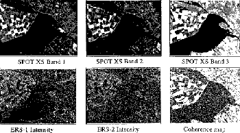
The data sources that are used in the classification are a SPOT-XS and a tandem pair of ERS-1 and ERS-2 SAR data. From the two radar images, which are in the Single Look Complex (SLC) format, a coherence map is created. This map reflects locally the amount of correlation between the two amount of correlation between the two images. The two radar datasets are acquired with a time difference of 24 hours (tandem mode). However, the same object or distributed target on these two radar images will cause a different pattern of intensities due to the appearance of multiplicative noise (speckle). A comparison of the difference of these two images will, therefore, show a large variance. The speckle is the result of the variation in the overall phase and the overall magnitude of cell with equal cover type.
It the two images would be taken from the same position and at the same moment, then the two images would be identical. Differences appear due to changes over time and/or the difference position of the sensors. The time dependent changes are more or less characteristic for the type of land cover and are, as such, a worthwhile feature in the classification process.
2. Data Description
The images were taken of an area in the central part of The Netherlands. It consists of a relatively new polder with large agricultural fields, a wetland put under agricultural fields, a wetland put under agriculture with some Redlands remaining; furthermore an are with small agricultural fields on the "old" land and parcels covered with forest. The old and the new land are separated by a take. In this area there are no relief differences; it is very flat terrain.
In order to classify the images samples supposed to be representatives for the various types of land cover were taken, and, at the same time, another independent set of samples was acquired to check the accuracy and reliability of the classifications. Field data was acquired of the images.
The eight classes that are selected did not change between the acquisition data and the field check.
The following classes were sampled :
- Bare soil (BS),
- Sugar bet (SB),
- Stubble (S),
- Forest (F),
- Maize (M)
- Grass (G),
- Water (W),
- Reed (R).
The datasets were classified with the use of the maximum likelihood classifier of the ILWIS software and the neural network classifier of the PCI software.
Table 1. Maximum Likelihood, SPOT B1, B2, B3
| BS | SB | S | F | M | G | W | R | uncl | | | ACC | ||
|
|
||||||||||||
| BS | | | 189 | 0 | 0 | 0 | 0 | 0 | 0 | 0 | 0 | | | 1.00 |
| SB | | | 0 | 356 | 0 | 0 | 0 | 3 | 0 | 0 | 3 | | | 0.98 |
| S | | | 0 | 0 | 251 | 0 | 0 | 0 | 0 | 0 | 0 | | | 1.00 |
| F | | | 0 | 0 | 0 | 221 | 0 | 0 | 0 | 29 | 3 | | | 0.87 |
| M | | | 0 | 0 | 0 | 0 | 46 | 1 | 0 | 128 | 0 | | | 0.26 |
| G | | | 0 | 1 | 0 | 0 | 114 | 326 | 0 | 47 | 0 | | | 0.67 |
| W | | | 0 | 0 | 0 | 0 | 0 | 0 | 414 | 0 | 0 | | | 1.00 |
| R | | | 0 | 0 | 0 | 0 | 57 | 1 | 0 | 29 | 0 | | | 0.33 |
|
|
||||||||||||
| REL | | | 1.00 | 1.00 | 1.00 | 1.00 | 0.21 | 0.98 | 1.00 | 0.12 | |||
average reliability = 78.98%
overall accuracy = 82.63%
Maximum Likelihood with SPOT data.
For the quality assessment of the classification methods applies for databasets in different methods applied for datasets in different compositions, the classification of the three SPOT XS bands by means of a maximum likelihood classifier was used as a reference. The result of this classification is shown in the confusion matrix in Table. Eerro.
Neural Network with SPOT data
To compare the strength of the neural network classifier in alalysing the same input, a neural net of 3 layers with 3, 8, and input, a neural net of 3 layers with 3,8, and 8 nodes, respectively, was trained in a varying number of iterations (500-2500). This experiment showed that after 500 iterations the network had already been trained. The overall accuracy of the classification using this network was almost identical to that of the maximum likelihood classifier.
average reliability = 77.06%
overall accuracy = 82.68%
The second experiment was executed to investigate the performance of a hybrid classification.
The classes with the highest accuracy were considered to have been sufficiently identified. The pixels belonging to these classes, including the NULL class, were used to create a mask. Next the remaining pixels were consisted of 3 layers with 3 inputs, 4 nodes in the hidden layer and 4 outputs.
The results of this experiment were :
average reliability = 76.07%
overall accuracy = 82.68%
In the following experiments, radar data was included in the classification. We investigated in which mode these data contribute best to the applied classification methods.
Neural Network with SPOT data (3 bands) + ERS1/2 intensity images
The feature space was here increase to a 5-dimensional one. The results of this combination were :
average reliability = 77.95%
overall accuracy = 84.69%
Neural Network with SPOT data (3 bands) + coherence map
The result of this classification is shown in Table 2.
Table 2. Neural Network SPOT B,B2,B3 + Coherence Map
| BS | SB | S | F | M | G | W | R | uncl | | | ACC | ||
|
|
||||||||||||
| BS | | | 189 | 0 | 0 | 0 | 0 | 0 | 0 | 0 | 0 | | | 1.00 |
| SB | | | 0 | 351 | 0 | 0 | 0 | 17 | 0 | 0 | 3 | | | 0.95 |
| S | | | 0 | 0 | 251 | 0 | 0 | 0 | 0 | 0 | 0 | | | 1.00 |
| F | | | 0 | 0 | 0 | 217 | 0 | 0 | 4 | 29 | 3 | | | 0.86 |
| M | | | 0 | 0 | 0 | 0 | 45 | 18 | 0 | 112 | 0 | | | 0.29 |
| G | | | 0 | 0 | 0 | 0 | 61 | 382 | 0 | 45 | 0 | | | 0.78 |
| W | | | 0 | 0 | 0 | 0 | 0 | 0 | 414 | 0 | 0 | | | 1.00 |
| R | | | 0 | 0 | 0 | 0 | 24 | 10 | 0 | 53 | 0 | | | 0.61 |
|
|
||||||||||||
| REL | | | 1.00 | 1.00 | 1.00 | 1.00 | 0.35 | 0.89 | 0.99 | 0.22 | |||
average reliability = 80.66%
overall accuracy = 85.37%
From table 2 it can be concluded that the Coherence map has a positive influence on the classification.To improve the influence of this map, the following classification was executed:
Neural Network with SPOT data (2 bands) + coherence map
The results were:
average reliability=82.58%
overall accuracy=87.12%
Table 3. Maximum Likelihood + Neural Network + SPOT B1,B2 +Coherence Map
| BS | SB | S | F | M | G | W | R | uncl | | | ACC | ||
|
|
||||||||||||
| BS | | | 189 | 0 | 0 | 0 | 0 | 0 | 0 | 0 | 0 | | | 1.00 |
| SB | | | 0 | 356 | 0 | 0 | 0 | 3 | 0 | 0 | 3 | | | 0.98 |
| S | | | 0 | 0 | 251 | 0 | 0 | 0 | 0 | 0 | 0 | | | 1.00 |
| F | | | 0 | 0 | 0 | 231 | 11 | 0 | 0 | 8 | 3 | | | 0.91 |
| M | | | 0 | 0 | 0 | 0 | 120 | 10 | 0 | 45 | 0 | | | 0.69 |
| G | | | 0 | 0 | 0 | 0 | 86 | 360 | 0 | 33 | 0 | | | 0.74 |
| W | | | 0 | 0 | 0 | 0 | 0 | 0 | 414 | 0 | 0 | | | 1.00 |
| R | | | 0 | 0 | 0 | 0 | 26 | 2 | 0 | 59 | 0 | | | 0.68 |
|
|
||||||||||||
| REL | | | 1.00 | 1.00 | 1.00 | 1.00 | 0.49 | 0.96 | 1.00 | 0.41 | |||
average reliability = 85.31%
overall accuracy = 89.27%
Overall accuracy is the highest for the combined classification of optical and microwave data. This holds particularly for those classes that had not been very accurately classified by the maximum likelihood classification of the optical data alone. Improvements were found for the classes maize, grass and reed, which had been poorly classified in the first experiment. Integration of the radar data was the successful in the coherence map format. The reason for this is the large variation homogeneous areas due to speckle, which influence is reduced in the coherence map. Finally, masking several classes that had been classified already with high accuracy, improves overall accuracy because of 1) the logical increase of the reliability in the confusion matrix and 2) the reduction in possible classes in the second pass. Investigations still need to be carried out in more detail as to whether this improvent is consistent for other areas.
References
- Benediktsson , J.A., Swain, P.H., and Ersoy, O.K. 1990. Neural network approaches versus statistical methods in classification of multisource remote sensing data, IEEE Transaction on Geosciences and Remote Sensing, 28, pp 540-551.
- Civo, D.L., 1991. Landsat TM image classification with an artificial neural network. Proceedings ASPRS-ACSM Annual Meeting, Balimore, MD. Vol. 3 pp. 67-77.
- Huurneman, G.C. Gens, R., and Broekema, L., 1996. Vienna, Vol II- p170.
- Schwablisch, M. and Winter, R., 1995, Erzeugung digitaler Gelandermodelle mit Methoden der SAR-Interferometry. DLR Nachrichten, Heft 79 (August 1995), pp 20-24.
- Wegmuller, U. and Werner, C.L., 1994Analysis of interferometer land surface signatures. Proceedings PIERS'94, Noordwijk, The Netherlands, Paper Code 039.
- Zebker, H.A. Werner, C.L., Rosen P.A. and Hensley, S., 1994. Accuracy of Topographic Maps Derived from ERS-1 Interferometric Radar. IEEE Transactions on Geoscience and Remote Sensing, Vol. 32 No 4, July 1994.